1. 29
September
2007
–
Press
release:
GeoGames
Launched
UMC
Medical
Center
in
3D
Google
Earth
(source:
http://visualcuriosity.blogs.com/home/2007/09/little-‐world-‐ne.html)
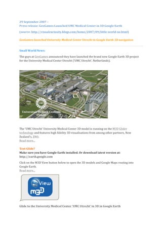
GeoGames
launched
University
Medical
Center
Utrecht
in
Google
Earth
3D
navigation
Small
World
News:
The
guys
at
GeoGames
announced
they
have
launched
the
brand
new
Google
Earth
3D
project
for
the
University
Medical
Center
Utrecht
('UMC
Utrecht',
Netherlands).
The
'UMC
Utrecht'
University
Medical
Center
3D
model
is
running
on
the
M3D
Glider
technology
and
features
high
fidelity
3D
visualisations
from
among
other
partners,
New
Zealand's,
ZNO.
Read
more...
Test-‐Glide?
Make
sure
you
have
Google
Earth
installed.
Or
download
latest
version
at:
http://earth.google.com
Click
on
the
M3D
View
button
below
to
open
the
3D
models
and
Google
Maps
routing
into
Google
Earth.
Read
more...
Glide
to
the
University
Medical
Center
'UMC
Utrecht'
in
3D
in
Google
Earth
2. Case,
Sept.
2007:
'Glide'
to
your
destinations
at
the
University
Medical
Center
Utrecht
in
3D
in
Google
Earth,
in
the
comfort
of
your
home.
Read
more...
The
UMC
Utrecht
client
is
dislayed
in
3D
into
Google
Earth
and
will
enable
1
Million+
visitors
per
year
to
look
up
their
hospital
visits
destinations
in
full
navigation
(Google
Maps),
from
the
comfort
of
their
homes.
The
UMC
Utrecht
organisation
says
this
will
help
reinforce
the
accessibility
of
premises
and
quality
of
services
by
helping
visitors
for
their
orientation
and
routing
inside
the
buildings
as
well,
to
many
polyclinics
and
treament
rooms
locations.
This:
24/7
GeoGames'
s
director
Jerome
Bertrand
says
this
kind
of
internet
3D
solution
is
usefull
for
medium
to
large
(semi-‐)
public
organisations
in
the
future.
In
a
world
getting
smaller
and
less
navigable
by
the
day,
one
will
need
to
get
a
fast
and
correct
spatial
picture
of
one's
destinations,
before,
after
and
during
the
actual
journey
on
site.
The
web
services
are
free.
Read
more
on
GeoGames's
Takeoff,
M3D
Glider
portal...
GIS
Magazine
interview,
September
2007
By
Guido
van
den
Heuvel,
Courtesy
of
GIS
Magazine,
The
Netherlands.
Translation
to
English:
Claudia
van
Lelyveld
Promising
young
start-‐up
company
integrates
GE
and
Virtual
Earth.
Geo-‐simulation
allows
you
to
give
a
stunning
aerial
introduction
to
your
business.
See:
www.geo-‐games.eu
[red.](company
website)
For
the
basic
version,
the
Globe
Glider
(free),
see:http://globeglider.net
The
commercial
version,
M3D
Glider:
www.geo-‐games.eu
([red.]
Glider
portal
GeoGames:
Takeoff.geo-‐games.eu
[red.]
(examples
can
be
viewed
here)
A
comprehensing
pilot
(including
interior
routing
in
3D)
can
be
viewed
in
the
legacy
website
from
GlobeGlider.net:
http://gg3.globeglider.net/takeoff/umcutrecht-‐indoor/
Drawing
inspiration
from
Google
Maps
and
Google
Earth,
GeoGames,
a
young
business
based
in
Utrecht
(Netherlands),
has
developed
the
M3D
Glider.
The
first
orders
have
already
been
received
for
the
web
application,
which
provides
an
advanced
new
way
to
display
business
information
about
a
company
and
about
its
physical
environment
to
a
wide
audience.
It
offers
an
interesting
aerial
‘business
card’
for
visitors,
business
contacts
and
prospective
clients.
Google
Maps
and
Google
Earth
are
by
now
well-‐known
and
highly
popular
applications.
But
Jerome
Bertrand,
director
of
GeoGames,
felt
that
for
the
end
user
they
lack
a
cohesive
element.
Together
with
his
associates
he
developed
the
M3D
Glider,
which
combines
simulations
from
the
gaming
world
with
supplementary
information
on
the
same
screen.
This
allows
the
web
application
to
show
an
organisation’s
clients
precisely
what
they
want
to
know:
how
do
I
get
3. there;
what
does
the
surrounding
area
have
to
offer;
what
will
my
hotel
room
look
like
and
where
can
I
find
a
great
parking
spot?
GeoGames’
objective
is
‘to
use
the
virtual
globe
as
an
accessible
medium
by
way
of
simulation’.
This
may
sound
somewhat
‘airy’,
but
in
this
case
that
is
a
very
positive
aspect.
Before
a
visit
you
swoop
and
soar
over
your
destination
in
flight.
During
the
flight
you
are
offered
relevant
information
about
your
‘target’.
Larger
clients
such
as
Volvo,
the
University
Medical
Centre
inUtrecht
and
Project
Development
Agency
Zuidas
are
already
using
the
GeoGames
Glider
and
its
supplementary
facilities.
Global
Jerome
Bertrand
started
out
as
an
audiovisual
and
graphic
designer.
He
set
up
GeoGames
after
he
saw
the
–
then
still
experimental
-‐
virtual
globe
by
Keyhole.
This
is
the
technique
which
forms
the
technological
basis
for
the
present
Google
Earth.
Jerome
Bertrand:
“It
was
all
still
rather
primitive
at
that
stage,
but
I
immediately
saw
there
was
a
future
in
direct
interactive
3D
visualisation
for
the
internet.”
Now
that
the
M3D
Glider
is
market-‐ready,
it
turns
out
that
public
authorities,
organizations
and
companies
are
all
too
eager
to
display
their
business
information
on
the
internet
in
a
game-‐like
way.
And
those
showing
an
interest
are
not
insubstantial
customers!
For
Amsterdam-‐based
Project
Development
Agency
Zuidas,
GeoGames
built
a
pilot
to
simulate
the
urban
developments
during
the
next
20
years
in
the
Zuidas
area
of
the
city,
in
real-‐time
3D.
Volvo
ordered
an
aerial
presentation
of
the
Volvo
Ocean
Race
2006,
and
the
new
Utrecht
University
Medical
Centre
(a
site
containing
9
buildings)
already
has
access
to
a
web
application
which
allows
visitors
to
fly
around
their
temporary
destination.
The
Glider
effortlessly
points
them
to
the
most
suitable
entrance
and…
parking
space.
Project
Developer
Slavenburg
use
the
Glider
to
display
a
new
waterside
development
on
the
IJ
in
central
Amsterdam.
Although
the
build
is
not
yet
complete,
it
is
already
possible
to
fly
within
and
over
the
building.
Last-‐minute
alterations
by
the
developer
are
retrieved
from
several
current
up-‐to-‐date
databases
during
the
Glide.
GeoGames
also
envisages
developments
for
the
GIS-‐world
in
the
areas
of
environment
and
energy.
The
Glider
would
easily
allow
a
fly-‐over
of
a
threatened
dyke-‐burst.
Most
of
the
examples
mentioned
can
be
found
on
http://takeoff.geo-‐games.eu.
An
up-‐to-‐date
version
of
Google
Earth
is
required
for
this.
M3D
Glider
The
principal
idea
behind
GeoGames
is
‘geo-‐simulated
environments’:
in
other
words
the
visualisation
and
simulation
of
location-‐bound
information.
The
M3D
Glider
makes
it
possible
to
view
3D
models
of
buildings,
urban
environments,
town
planning
designs
and
even
moving
vehicles.
The
web
application
is
called
‘Glider’
because
the
user
can
fly
smoothly
from
one
point
to
another,
whilst
the
software
instantly
retrieves
the
location-‐bound
information
from
the
synchronised
browser.
The
web
application
adds
several
web
functions
to
those
already
in
existence
on
Google
Earth.
GeoGames
developed
the
Glider
with
partner
Bernhard
Sterzbach
of
Globe
Glider
and
works
in
co-‐operation
with
4
partners
located
in
Holland,
Germany,
the
United
States
and
New
Zealand.
To
optimize
visual
presentations,
the
Glider
can
be
linked
to
several
databases.
For
example,
at
this
moment
it
is
possible
to
view
over
900.000
photos
on
Flickr.com
and
Geosnapper.com
via
4. the
server.
These
photos
have
been
‘geotagged’
by
users,
i.e.
linked
to
a
geographical
location,
and
will
appear
depending
upon
the
location
the
user
is
viewing
at
that
moment.
Jerome
Bertrand:
“The
real
added
value
happens
when
you
start
to
filter
and
modify
the
information
to
serve
the
end
user.
For
example,
if
booking
a
holiday
online
an
interactive
map
can
enable
the
user
to
enjoy
a
taste
of
the
area
in
advance.”
Market
Potential
According
to
GeoGames
there
is
a
high
demand
for
advanced
types
of
geo-‐simulation.
Jerome
Bertrand:
“The
same
information,
available
to
everyone,
at
the
same
time,
all
over
the
world
–
was
once
a
revolutionary
idea.
We
are
now
moving
in
the
direction
of
a
spacebound
web
(or
spatial
web)
where
websites,
data
and
information
are
linked
to
degrees
of
latitude
and
longitude.
Businesses
want
user
accessibility.
Using
routing
and
tracking,
we
can
enable
and
expand
this
for
use
in,
for
example,
the
travel
industry,
hospitals,
property
development
and
the
hospitality
business.
Guests
and
customers
can
view
their
destination
in
3D
in
advance
of
their
visit
and
opt
for
the
best
choices.
Moreover,
we
ensure
that
this
information
is
directly
linked
to
possible
transactions
such
as
booking
services
or
online
payment.
Technologically,
we
are
the
only
ones
able
to
effortlessly
combine
location
databases
and
financial
transactions.
We
are
an
independent
provider
and
can
combine
Google
Earth
and
Microsoft’s
Virtual
Earth
in
one
package
without
any
problem.
In
future
we
also
envisage
potential
applications
in
education,
information
services
and
simulation.”
To
Conclude
New
pilots
of
the
Glider
are
currently
under
development
for
travel
booking
and
reservation
systems,
for
publishers
of
sport
and
leisure
magazines
and
for
holiday
resorts.
As
well
as
these,
GeoGames
will
ultimately
also
use
the
Glider
to
develop
games
for
educational
purposes.
It
will
shortly
be
possible
to
download
free
demos
on
http://geo-‐games.eu
and
to
add
(after
registration)
your
own
(3D)
project
to
existing
platforms.
The
M3D
tool
was
realized
with
the
support
of
Syntens
as
part
of
the
LiveWIRE
support
project
for
technically
innovative
businesses.
The
web
application
is
not
for
sale,
and
only
offered
in
combination
with
other
services.
Syntens
support
GeoGames
received
support
from
Syntens.
Syntens-‐consultant
Martijn
van
Groen
on
GeoGames:
“In
2006
Bertrand
knocked
on
our
door
and
asked
for
our
assistance
with
the
final
development
and
marketing
of
the
M3D
Glider.
The
product
was
not
yet
market-‐ready.
As
part
of
the
LiveWIRE
programme
Syntens
arranged
coaching
and
advice
on
sourcing
finance.
Jerome
Bertrand
came
into
contact
with
a
number
of
valuable
partners
as
a
result
of
this.
Syntens
also
helped
to
fine-‐tune
the
business
plan.
You
often
see
starter
companies
who
are
looking
for
finance
but
find
it
difficult
to
approach
the
subject
with
potential
partners.
They
would
rather
escape
into
discussions
about
partnership
possibilities
regarding
the
core
business
activity
itself.
My
advice
in
that
case:
if
no-‐one
knows
you
could
use
some
help,
nobody
will
offer
it.
Just
talk
about
it.”
Author:
Guido
van
den
Heuvel
Translation
to
English:
Thanks
to
Claudia
van
Lelyveld
Copyright
GIS
Magazine,
The
Netherlands,
September
2007.
See:
www.geo-‐games.eu
(company
website)
5.
For
the
basic
version,
the
Globe
Glider
(free),
see:http://globeglider.net
The
commercial
version,
M3D
Glider:
www.geo-‐games.eu
Glider
portal
GeoGames:
Takeoff.geo-‐games.eu(examples
can
be
viewed
here)


For
the
basic
version,
the
Globe
Glider
(free),
see:http://globeglider.net
The
commercial
version,
M3D
Glider:
www.geo-‐games.eu
([red.]
Glider
portal
GeoGames:
Takeoff.geo-‐games.eu
[red.]
(examples
can
be
viewed
here)
A
comprehensing
pilot
(including
interior
routing
in
3D)
can
be
viewed
in
the
legacy
website
from
GlobeGlider.net:
http://gg3.globeglider.net/takeoff/umcutrecht-‐indoor/
Drawing
inspiration
from
Google
Maps
and
Google
Earth,
GeoGames,
a
young
business
based
in
Utrecht
(Netherlands),
has
developed
the
M3D
Glider.
The
first
orders
have
already
been
received
for
the
web
application,
which
provides
an
advanced
new
way
to
display
business
information
about
a
company
and
about
its
physical
environment
to
a
wide
audience.
It
offers
an
interesting
aerial
‘business
card’
for
visitors,
business
contacts
and
prospective
clients.
Google
Maps
and
Google
Earth
are
by
now
well-‐known
and
highly
popular
applications.
But
Jerome
Bertrand,
director
of
GeoGames,
felt
that
for
the
end
user
they
lack
a
cohesive
element.
Together
with
his
associates
he
developed
the
M3D
Glider,
which
combines
simulations
from
the
gaming
world
with
supplementary
information
on
the
same
screen.
This
allows
the
web
application
to
show
an
organisation’s
clients
precisely
what
they
want
to
know:
how
do
I
get](data:image/gif;base64,R0lGODlhAQABAIAAAAAAAP///yH5BAEAAAAALAAAAAABAAEAAAIBRAA7)