Presentation of MSc research at the CAA 2016 - Oslo. Session 20 "Computer vision vs human perception in remote sensing image analysis: Time to move on".
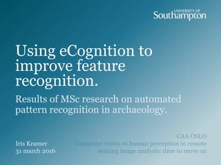
24. Roundbarrow
Mound
Round
has shape
is defined by
…
(varied sizes)
has size
Ditch
possibly
surrounded by
Bank
possibly
surrounded by
Flora
Agriculture
possibly
(partly)
levelled
Fauna
possibly
(partly)
destroyed
has landcover
Barrow Earthworkis type of is type of
is type of
26. Barceló, J. A. 2008. Computational Intelligence in Archaeology, Hershey, New York, IGI.
Blaschke, T., and Strobl, J. 2001. What's wrong with pixels? Some recent developments interfacing
remote sensing and GIS. Geo-Informations-Systeme, 14, 12-17.
van den Eeckhaut, M., Kerle, N., Poesen, J., and Herv‡s, J. 2012. Identification of vegetated landslides
using only a Lidar-based terrain model and derivatives in an object-oriented environment. Proceedings
of the 4th GEOBIA, 211.
Niemeyer, I., Marpu, P. R., and Nussbaum, S. 2008. Change detection using object features. In:
Blaschke, T., Lang, S., and Hay, G. J. (eds.) Object-Based Image Analysis: Spatial Concepts for
Knowledge-Driven Remote Sensing Applications. Verlag: Springer.
TRIMBLE eCognition Developer 9.1
Hinweis der Redaktion
Beginning 20th century - Remote sensing (raster) vs. GIS (predominantly vector)
Hierarchical grouping of smaller segmented image elements based on decision rules
The data used in their research consisted of scanned aerial photography with a 0.25 m ground sample distance of Southampton, England, obtained from the Ordnance Survey of Great Britain (figure 20, left). Most boundaries in remotely sensed images consist of both an intensity and texture boundary. In this case the gradient of each of these images were fused into one image (figure 20, middle) which enabled the segmentation of meaningful objects (figure 20, right). The achieved results were very accurate and outperformed the generally applied Canny gradient operator.
The main problems in rule definition within the archaeological record is that it is almost always incomplete: not all past material things have remained until today or are found destructed. So, in order to replicate an archaeologist it must be able to reconstruct incomplete data for which Barceló— (2008, 49) identified the following key concepts.
Compound features
Geomorphic fingerprint
Separated by principles of vision
Bronze age barrow cemetery, Oxfordshire
by Hamish Fenton 2003
Bronze age barrow cemetery, Oxfordshire
by Hamish Fenton 2003
Bronze age barrow cemetery, Oxfordshire
by Hamish Fenton 2003
Bronze age barrow cemetery, Oxfordshire
by Hamish Fenton 2003
Avebury is a Neolithic henge monument which contains the largest stone circle in Europe.
Discussion platform of eCognition is good, like Stackoverflow
Short term: object based. With real investments we can move towards machine learning and pixel based: good database of features.