Airborne Remote Sensing of Institute for Environmental Solutions
•
4 gefällt mir•679 views

The Institute for Environmental Solutions (IES) is a transdisciplinary research institute that has expertise in applying remote sensing to manage natural resources and the environment. IES operates an Airborne Surveillance and Environmental Monitoring System called ARSENAL that uses various sensors to collect high quality spectral data on ecosystems, landscapes, water resources and other areas. IES conducts projects in areas such as mapping habitats, monitoring the marine environment, detecting oil spills and modeling the impacts of future satellites.

Empfohlen
Empfohlen
Weitere ähnliche Inhalte
Andere mochten auch
Ähnlich wie Airborne Remote Sensing of Institute for Environmental Solutions
Ähnlich wie Airborne Remote Sensing of Institute for Environmental Solutions (20)
Kürzlich hochgeladen
Kürzlich hochgeladen (20)
Airborne Remote Sensing of Institute for Environmental Solutions
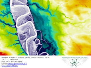
- 1. Address: «Lidlauks», Priekuļi Parish, Priekuļi County, LV-4101 Tel.: +371 64127951 Mob. tel.: + 371 26425688 E-mail: lidlauks@videsinstituts.lv www.videsinstituts.lv Time-lapse of the Gauja River flow
- 2. Science Institutes – Higher Education – NGO – Public Sector Partnership Network Scope of the institute: Science – Technologies – Art – Applied Environmental Solutions
- 3. Institute for Environmental Solutions Digital Surface Model of the Burtnieki Lake IES is transdisciplinary research institute Has strong expertise in the application of advanced remote sensing for management of natural resources and environment Ecosystem processes Cultural heritage Wild animal ecology Forest management Water resources Biodiversity Landscape ecology Land use/ Land cover
- 4. Institute for Environmental Solutions LIDAR laser scanner UVC sensor 280-375 nm SWIR sensor 950-2450 nm MWIR sensor 3000-5000 nm High resolution RGB sensor LWIR sensor 8000-12000 nm IR sensor 3700-4800 nm VIS-NIR sensor 380-1050 nm 100 km²/h 6 – 8h400kg 400-500m IES has developed a unique Airborne Surveillance and Environmental Monitoring System ARSENAL YL-FBI
- 5. Institute for Environmental Solutions Spectral range of Airborne Surveillance and Environmental Monitoring System ARSENAL BeesHumanSnakes
- 6. YL-FBI Freshwater Terrestrial Marine Ecosystem structure Chemical composition Spatial characteristics ARSENAL’s sensors provide a high quality data of:
- 7. Institute for Environmental Solutions Hyperspectral Data Use for the Study of Land R=1632nm; G=1242nm; B=1018nm R=845nm; G=550nm; B=675nm R=650nm; G=550nm; B=465nm
- 8. Institute for Environmental Solutions Hyperspectral Data Use for the Study of the Baltic Sea R=744nm; G=712nm; B=666nm R=650nm; G=560nm; B=485nm
- 9. Fighting poaching Alternative use of grassland biomass Marine monitoring Oil spill detection Simulation of the future satelites Mapping of valuable grasslands Modelling of corn-crake habitats Mapping habitats of the EU importance Restoring the hydrological regime Cultural heritage P R O J E C T S Invasive species detection Survey of fish migration Innovative approach for lake survey Restoration of habitats in coastal lakes Forest habitat restoration
- 10. PECS: Simulation of Future Satellites of European Space Agency Sentinel – 2: improved classification of land use/ land cover; Sentinel – 3: analysis of the Baltic Sea watersImage: ESA
- 11. PECS: Simulation of Future Satellites of European Space Agency Projects The use of airborne remote sensing data for evaluation of grassland biomass.
- 12. «Balex Delta 2014» Training for Oil Spill Detection in the Baltic Sea Parameters of pollution object: ~85m2 Lenght 65m Wide ~ 3m Coverage 30%
- 13. Training for Oil Spill Detection in the Baltic Sea. Visible colour image Thermal image Temperature imageSpectral data image
- 14. Innovative Approaches for Marine Biodiversity Monitoring. Chlorophyll concentration assessment in the Baltic Sea
- 15. Sea is a Constantly Changing Ecosystem. Measuring the same region before and after 1h 20min chlorophyll concentration is different. Institute for Environmental Solutions
- 16. Automatic Identification of Birds Using Aerial Imaging within the Gulf of Riga
- 17. BIRD BIRD BIRD Automatic Identification of Birds Using RGB and Thermal Imaging Thermal imageAerial image Photo: A.Auniņš Photo: A.Auniņš
- 18. New Discoveries within Marine Monitoring Hyperspectral image of sea birds in water. The image shows churned up water (blue line) which follows the path of sea bird (white dot) swimming.
- 19. Mapping Shallow Water Environment and Underwater Habitats in the Baltic Sea Name Color Deep blue Blue Shallow brown Red Shallow yellow Yellow Deep vegetated Green Green areas Cyan Deep water Magenta Medium vegetated Maroon
- 20. We have been worried by the growing tendency of illegal fishing during the spawning seasons in Latvia! Fighting Poaching
- 21. Therefore, we applied Innovative Means for Fighting Poaching By using ARSENAL’s infrared sensors IES can easily notice poacher’s most appreciated fishing places.
- 22. New Discoveries within the Fighting Poaching Project Detected animals using infrared sensors at night time.
- 23. Innovative methods for Mapping the Habitats of European Union (EU) Importance Ground truthing within Tiras bog Ground truthing within Ķirba marsh Ground truthing within Pape sand-dune 14. 26. 19.
- 24. Mapping of Habitats of the European Union (EU) importance Hyperspectral image of highly protected Randu meadows
- 25. Mapping of Habitats of the European Union (EU) Importance False colour image produced using hyperspectral data set highlighting different tree species in a high value biodiversity forest on the banks of the Ogre River oxbows.
- 26. Modelling of Corn-crake Habitats within Natura 2000 Territory «Dviete floodplain» The Corncrake (Crex crex) is a protected species. Dviete floodplain is the breeding ground for approximately one quarter of Europe’s corncrake population (26,000-38,000 pairs).
- 27. Habitat Suitability Map for the Corncrake (Crex crex) within the Dviete Floodplain and Its Surroundings Designation Colour Not suitable Deep blue Poorly suited Turquoise Suboptimal Yellow Optimal Red
- 28. Integrated Planning Tool to Ensure Viability of Grasslands 1 2 3 Hyperspectral image of the oxbows of the Ogre river 1. Cēsis Municipality 2. Farm «Šovītes» 3. Madliena Parish
- 29. Alternative Use of Grassland Biomass 1 2 Hyperspectral image of agricultural grasslands 1. Sigulda Municipality 2. Ludzas Municipality
- 30. Forest Habitat Mapping and Restoration within the Gauja National Park (GNP) Hydrology restoration of Bog woodland. DTM of the Gulbjusala Bog in GNP DSM, Hyerspectral image and DTM of the Gauja River Valley in GNP
- 31. Classification of Tree Species in Gauja National Park
- 32. Digital Terrain Model (DTM) of the Gauja River Valley within the Gauja National Park The Ancient Valley of the Gauja River. DTM, aside ditches and EU protected forests of slopes, screes and ravines (9180*) in the Gauja National Park.
- 33. Development of Methodology for Identification and Biomass Assessment of the Giant Hogweed (Heracelum sosnowskyi) (State Plant Protection Service) The spread of Giant Hogweed in Latvia The highly invasive, fast spreading Giant Hogweed can grow up to 4 meters and its toxic sap causes severe burns and blistering
- 34. Development of Methodology for Identification and Biomass Assessment of the Giant Hogweed (Heracelum sosnowskyi) The Giant Hogweed’s (Heracleum sosnovskyi) biomass ranging from 45-80 tonnes per hectare
- 35. Development of Methodology for Identification and Biomass Assessment of the Giant Hogweed (Heracelum sosnowskyi) 1 tonne of the Giant Hogweed’s (Heracleum sosnovskyi) biomass can be used to extract 30 to 50 litres of biofuel.
- 36. KNP is a wetland national park. Since 2004, it has been a part of the NATURA 2000 network. Restoring the Hydrological Regime of Ķemeri National Park (KNP) Floodplain grasslands Raised Bogs Mineral water forming Coastal lakes Swamp forests Floodplain forests Calcareous fens
- 37. Restoring the Hydrological Regime of Wetland Forests within the Ķemeri National Park DTM and a scheme of the wetland forest habitat restoration plan for the Skudrupīte River DTM with a drainage system in wetland forests
- 38. Restoring the Hydrological Regime of Swamp Forests within the Ķemeri National Park (KNP) DTM with the drainage system and project restoration measures in the wetland forests DTM and the close up of drainage system (open ditch network) within KNP
- 39. Restoration of Bittern Habitats in Coastal Lakes Bittern Botaurus (Botaurus stellaris) Hyperspectral image of the Engure Lake’s coast 1 2 1. Lake Engure 2. Lake Pape
- 40. Innovative Approach for Lake Survey in Latvia 1. 2. 3. 4. 1. 40,07 km2 2. 15,44 km2 3. 0,33 km2 4. 0,58 km2
- 41. Food chain survey Scientific fish sampling Mapping the macrophytes Modelling ecosystem’s processes Expertise of Czech and Finnish partners Holistic Survey of Lake Ecosystem
- 42. Mapping Lake’s Overgrowth using Hyperspectral Sensors Lake Burtnieks Colour Macrophytes Yellow Water-lilies Red Club-rush groves Green Reed beds
- 43. Survey of Fish Migration Projects Fish tracking to survey their migration habits
- 44. In Search for Archaeological Heritage in Agricultural and Grasslands: Case of Koknese Fortress
- 45. In Search for Archeological Heritage in Agricultural and Grasslands: Case of Koknese Fortress Digital Terrain Model reveals a part of the Koknese fortification system.
- 46. In Search for Archeological Heritage in Agricultural and Grasslands: Case of Koknese Fortress Aerial image of agricultural fields in Koknese parish
- 47. In Search for Archaeological Heritage in Agricultural and Grasslands: Case of Koknese Fortress Hyperspectral image of agricultural fields in Koknese parish
- 48. Research of the Medieval Defense System of Straupe Parish Aerial photography of the central part of Straupe parish
- 49. Location of Lielstraupe castle Pond system Brasla River Location of Straupe Harbor Roads and bridges Fortification ditches Research of the Medieval Defense System of Straupe Parish Digital Terrain Model revealing a well-preserved medieval defence system
- 50. Address: «Lidlauks», Priekuļi Parish, Priekuļi County, LV-4101 Tel.: +371 64127951 Mob. tel.: + 371 26425688 E-mail: lidlauks@videsinstituts.lv www.videsinstituts.lv Time-lapse of the Gauja River flow
Hinweis der Redaktion
- Spektra kanāli attēlos: 1.Attēls no kreisās - R=1632nm(sarkans), G=1242nm(zaļš), B=1018nm(zils) 2.Attēls - R=845nm (infrasarkans), G=550nm (zaļš), B=675nm (sarkans) 3.Attēls - R=650nm (sarkans), G=550nm (zaļš), B=465nm (zils)
- Bilde nr.1: R(744nm) G(712nm) B(666nm) Bilde nr.2: R(650nm) G(560nm) B(485nm)