Tropical Mountain Mires and New Geographies of Water in the Santa River Watershed
•
1 gefällt mir•583 views

This document summarizes research on tropical mountain mires in the Santa River watershed in Peru. The mires are situated within a social-ecological system experiencing impacts from glacier recession due to climate change. Analysis of satellite imagery from 2000 to 2011 found that mire extent decreased by 17.2% or 33 hectares in one valley as hydrologic changes altered the landscape. The mires provide important ecosystem services like water storage and filtration and are linked to shifts occurring throughout the watershed from climate impacts on glaciers and human water usage. The research aims to better understand the coupled natural and human dynamics influencing the region's hydrology.
Empfohlen

Empfohlen
Weitere ähnliche Inhalte
Was ist angesagt?
Was ist angesagt? (20)
Ähnlich wie Tropical Mountain Mires and New Geographies of Water in the Santa River Watershed
Ähnlich wie Tropical Mountain Mires and New Geographies of Water in the Santa River Watershed (20)
Mehr von InfoAndina CONDESAN
Mehr von InfoAndina CONDESAN (20)
Tropical Mountain Mires and New Geographies of Water in the Santa River Watershed
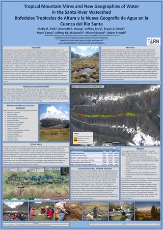
- 1. Tropical Mountain Mires and New Geographies of Water in the Santa River Watershed Bofedales Tropicales de Altura y la Nueva Geografía de Agua en la Cuenca del Río Santa Molly H. Polk1, Kenneth R. Young1, Jeffrey Bury2, Bryan G. Mark3, Mark Carey4, Jeffrey M. McKenzie5, Michel Baraer6, Adam French2 1 Department of Geography and the Environment, University of Texas at Austin, mollypolk@utexas.edu, kryoung@austin.utexas.edu 2 Department of Environmental Studies, University of California, Santa Cruz, jbury@ucsc.edu 3 Department of Geography and Byrd Polar Center, The Ohio State University, mark.9@osu.edu 4 Robert D. Clark Honors College, University of Oregon, carey@uoregon.edu 5 Earth and Planetary Sciences, McGill University, jeffrey.mckenzie@mcgill.ca 6 École de Technologie Supérieure, Université du Québec, michel.baraer@etsmtl.ca ABSTRACT Understanding the consequences of climate change and the complex interactions between biophysical and social components requires novel research approaches. Integrating disciplinary strengths within the framework of social-ecological systems theory is a promising model that can lead to novel insights into the responses of humans and nature. Mountain mires inside Huascarán National Park are situated within a social-ecological system that is experiencing the impacts of glacier recession. These hydrologic disturbances are inducing ecological shifts and related social adaptations. Spatial alterations have been documented and are occurring as regional-scale land use and land cover shift. Changes in mountain mires are a symbol of new geographies of water and climate change within Peru that offer an opportunity to investigate coupled systems. With their high capacity to store water, mires inside the Park are an important link in Santa Basin hydrology, a large watershed that is heavily influenced by glacier recession and pressure created by rapid and water-intensive economic development. Shifting hydrologic regimes caused by climate-induced glacier recession will require assessment tools that consider social and economic needs, biodiversity effects, and other downstream consequences. STUDY AREA Huascarán National Park is located in the department of Ancash, Peru (Figure 1). It was established in 1975 and is home to the world’s highest tropical mountain range, the Cordillera Blanca. It provides habitat for the spectacled bear, vicuña, and Andean condor, among other important animal species and plant communities. The glacial valleys of the study area serve multiple land use goals although they are zoned by Huascaran National Park for protection of native plants and animals. In practice the park is used by local people for livestock grazing, by park visitors for recreation, and by the neighboring city of Huaraz as a source area for the municipal water supply. Glacial melt drains into the Santa River, which runs along the valley bottom of the Callejón de Huaylas and provides water to local communities and agro-industrial interests on the coast. Approximately 267,000 inhabitants live in the region. TROPICAL MOUNTAIN MIRES The tropical alpine wetlands in the study area are mire complexes comprised of fens and bogs, with peaty soils dominated by sedges and rushes. They form along lake and stream margins, in some cases covering valley bottoms where the water table is high or perched. The humid peats consist of decomposing plant materials with high soil porosity and low bulk density. Associated high water storage capacity thus provides environmental buffering during the dry season. Organic material in mire complexes stores vast amounts of carbon and, as a result, there is growing interest in the role of mire systems in global environmental change. RESULTS The change detection from 2000 to 2011 revealed wetland loss in Quilcayhuanca valley by 17.2% or 33 ha (Table 1). Other results are as follows: • The 2006 classified image revealed that most overall loss occurred early in the decade, as there was a slight increase in wetland extent from 2006 to 2011. • Wetland loss from 2000 to 2006 included an increase in habitat fragmentation, with smaller, more numerous, and more clustered wetland patches. • By 2011 there were only 118 wetland patches, because many of the small isolated patches had vanished. The changes illustrated in Figure 2 show that a number of processes were involved. From 2000 to 2011 much of the wetland loss in the valley bottoms was due to contraction, implying less total water moving through valley bottom substrates. The valley sides and higher elevations had the loss of isolated wetlands, implying that springs or small streams once connected to uphill glaciers are drying out. There was some wetland expansion, spatially constrained to valley bottoms and presumably caused by new surface flows to those particular places. Figure 2. Wetland change from 2000 to 2011. RESUMEN Comprender las consecuencias del cambio climático y las interacciones complejas entre los componentes biofísicos y sociales requieren una estrategia novedosa de investigación. La fortaleza de la integración de disciplinas en el marco teórico de sistemas socio-ecológicos es un modelo promisorio que podrá conducir a entendimientos originales de la respuestas del ser humano y la naturaleza. Pantanos montanos (bofedales) en el Parque Nacional Huascarán están ubicados en un sistema socio-ecológico que experiencia los impactos de la recesión glaciar. Estas perturbaciones hidrológicas son inducidas por cambios ecológicos y adaptaciones sociales vinculadas. Los cambios espaciales han sido documentados y están ocurriendo junto a los cambios de escala regional en uso del espacio y cobertura de este. Los cambios en los pantanos de montaña son un símbolo de geografías nuevas de cambio en agua y clima en el Perú que ofrecen una oportunidad para investigar estos sistemas apareados. Dada la alta capacidad de almacenamiento, los pantanos en el Parque son un vínculo importante para la hidrología de la cuenca del Santa; una cuenca altamente influenciada por la recesión glaciar, así como por las presiones creadas por el crecimiento económico rápido y de uso intensivo de agua. Por tanto, los regímenes hidrológicos cambiantes debido a clima y recesión glaciar requerirán instrumentos de evaluación en los que se incluyen consecuencias sociales, necesidades económicas, efecto a la biodiversidad y otras a lo largo de la cuenca. Landscape Metrics 2000 2006 2011 Wetland extent (ha) 191.7 141.93 158.67 Nonwetland extent (ha) 9230 9279.8 9263.1 Number wetland patches 135 141 118 Wetland patch density (per 100 ha) 0.6211 0.6487 0.5429 Mean wetland patch area (ha) 1.42 1.01 1.35 Mean Euclidean nearest neighbor (m) 149.23 122.82 142.9 COUPLED NATURAL HUMAN SYSTEMS Tropical mountain mires are embedded within the hydrologic system of the Cordillera Blanca. As climate change influences regional hydrologic shifts, mountain mires will be impacted by new dynamics. Positioned between the glaciers and their lakes and the downslope environments, wetlands thus provide a way to link shifts in the glacial-hydrological system with the demand for and use of water resources. The results reported in this poster are part of a larger, transdisciplinary research project that is analyzing the complex interactions among global, regional, and local processes of anthropogenic and biophysical drivers of hydrologic change in the Santa River watershed. The project takes an approach that is both collaborative and integrated to empirically examine the effects of recent climatic and social change in the watershed. Using this coupled natural human systems framework, the project will provide new insights about the role of water in shifting and dynamic social-ecological systems. REFERENCES Bury, J., B. G. Mark,M. Carey, K. R. Young, J. McKenzie, M. Baraer, A. French, and M. H. Polk. 2013. New geographies of water and climate change in Peru: coupled natural and social transformations in the Santa River watershed. Annals of the Association of American Geographers 103:363–374. FUNDING Funded by the United States National Science Foundation CNH Award Number 1010132: Hydrologic Transformation and Human Resilience to Climate Change in the Peruvian Andes. MOUNTAIN MIRE ECOSYSTEM SERVICES Numerous ecosystem services have been identified: pasture for grazing carbon storage biodiversity conservation water supply for urban centers power generation temporary water storage groundwater recharge sediment accretion nutrient filtration pollution removal/bioremediation microclimate regulation water purification migratory bird habitat aesthetic value recreation value Table 1. Metrics reporting temporal and spatial wetland change. Figure 1. Study Area.