GI2013 Final Programme+Proceedings
•
1 gefällt mir•5,497 views

GI2013 Final Programme & Proceedings
![GI2013 – GI/GIS/GDI – Forum
GeoINSPIRE’d Cross-border-Interoperability
Grenzüberschreitendes 13. Sächsisches GI/GIS/GDI-Forum am 29./30. April 2013 in Dresden
Sustainability & Security Applications for GEO-Risk-Prevention & ENVIRO-Disaster-Protection
"GeoINSPIRE'd X-border-Interoperability for Digital Europe 2020"
SUSTAINABILITY OF INTER-REGIONAL COLLABORATION
European Commission Support Programme 2007 – 2013 for “Inter-Regional Collaboration” in Free State of Saxony
GI2013 – INTER-REGIONAL PROGRAMME & SCIENTIFIC – COMMITTEE
International Academicians of IEAS & Scientific Programme Members:
CHAIRS: Doz. Dr. F. HOFFMANN (IEAS/DE) & Dr. K. CHARVAT (CCSS/CZ)
Prof. BEHR (HFT/DE), Dir. D. BUONO (CNR/IT), Dr. FURDIK (STUBA/SK), Dir. K. ILIEV (CNSDR /BG),
Dr. K. JANECKA (WBU/CZ), Prof. M. KONECNY (IEAS/MUNI/CZ), Doz. Dr. P. KUBICEK (MUNI/CZ),
Dir. W. MAYER (PROGIS/AT), Dir. J. PAPEZ (FLOOD-NGO/CZ), Dipl.Ing. P. VOHNOUT (CCSS/CZ)
ORGCOM-Members: Dr. G. HOFFMANN (IGN), Prof. S. KLOSS (IGN), Dr. K.-D. MICHAEL (IGN).
ORGANIZER’S INFORMATION & INTERNET REFERENCE URL’S
GI2013-Contact-Address
CCSS-Praha
IGN-Dresden
SOCIAL NETWORKS
[ Mailto:GI2013@IGN-SN.de ]
[ http://www.CCSS.cz ]
[ http://GDI-SN.blogspot.com ]
[ INSPIRE-FORUM ] + [ FACEBOOK ] + [ LINKEDIN ] + [ TWITTER ]
IMPRESSUM:
Herausgegeben von / Published by
( Founding Members of IGN e.V. )
Doz. Dr. Frank HOFFMANN, CSc
IGN – Vorstandsvorsitzender, Dresden
INNOVATION. Grenzüberschreitendes Netzwerk e.V.
Dr. Karel CHARVAT, EU-Project Manager
CCSS – Past President, Praha
Czech Center for Science and Society e.V.
INNOVATION. Grenzüberschreitendes Netzwerk
( Gemeinnütziger e.V. / Non-profit Organization )
c/o IGN-Vorstand, Martin-Andersen-Nexö-Str. 4
D – 01217 DRESDEN / Saxony / Germany
EMAIL:
SKYPE:
INTERNET:
WEBLOG:
TEL/FAX:
[ GI2013@IGN-SN.de | Vorstand@IGN-SN.de ]
[ fh_ign ]
[ http://www.IGN-SN.de ]
[ http://GDI-SN.blogspot.com ]
[ +49-351-403.2729 # FAX: +49-351-401.4260 ]
Copyright © 2013 by CCSS-Praha & IGN-Dresden – All rights reserved.
NNR-Special-Edition-2013
PROCEEDINGS – “GI2013-X-border-GI/GIS/GDI-FORUM” – DRESDEN
ISSN 1801-6480
2](data:image/gif;base64,R0lGODlhAQABAIAAAAAAAP///yH5BAEAAAAALAAAAAABAAEAAAIBRAA7)
Empfohlen
Empfohlen
Weitere ähnliche Inhalte
Was ist angesagt?
Was ist angesagt? (11)
Andere mochten auch
Andere mochten auch (20)
Ähnlich wie GI2013 Final Programme+Proceedings
Ähnlich wie GI2013 Final Programme+Proceedings (20)
Mehr von IGN Vorstand
Mehr von IGN Vorstand (20)
Kürzlich hochgeladen
Kürzlich hochgeladen (20)
GI2013 Final Programme+Proceedings
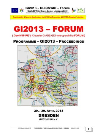
- 1. GI2013 – GI/GIS/GDI – Forum GeoINSPIRE’d Cross-border-Interoperability Grenzüberschreitendes 13. Sächsisches GI/GIS/GDI-Forum am 29./30. April 2013 in Dresden Sustainability & Security Applications for GEO-Risk-Prevention & ENVIRO-Disaster-Protection GI2013 – FORUM ( GeoINSPIRE’d X-border-GI/GIS/GDI-Interoperability-FORUM ) PROGRAMME – GI2013 – PROCEEDINGS EUROPEAN BORDER REGIONS - MAP © COURTESY BY AEBR, 2011 ( Compiled 2007 at IfL ) 29. / 30. APRIL 2013 DRESDEN GI2013 © IGN e.V. NNR-Special-Edition-2013 PROCEEDINGS – “GI2013-X-border-GI/GIS/GDI-FORUM” – DRESDEN ISSN 1801-6480 1
- 2. GI2013 – GI/GIS/GDI – Forum GeoINSPIRE’d Cross-border-Interoperability Grenzüberschreitendes 13. Sächsisches GI/GIS/GDI-Forum am 29./30. April 2013 in Dresden Sustainability & Security Applications for GEO-Risk-Prevention & ENVIRO-Disaster-Protection "GeoINSPIRE'd X-border-Interoperability for Digital Europe 2020" SUSTAINABILITY OF INTER-REGIONAL COLLABORATION European Commission Support Programme 2007 – 2013 for “Inter-Regional Collaboration” in Free State of Saxony GI2013 – INTER-REGIONAL PROGRAMME & SCIENTIFIC – COMMITTEE International Academicians of IEAS & Scientific Programme Members: CHAIRS: Doz. Dr. F. HOFFMANN (IEAS/DE) & Dr. K. CHARVAT (CCSS/CZ) Prof. BEHR (HFT/DE), Dir. D. BUONO (CNR/IT), Dr. FURDIK (STUBA/SK), Dir. K. ILIEV (CNSDR /BG), Dr. K. JANECKA (WBU/CZ), Prof. M. KONECNY (IEAS/MUNI/CZ), Doz. Dr. P. KUBICEK (MUNI/CZ), Dir. W. MAYER (PROGIS/AT), Dir. J. PAPEZ (FLOOD-NGO/CZ), Dipl.Ing. P. VOHNOUT (CCSS/CZ) ORGCOM-Members: Dr. G. HOFFMANN (IGN), Prof. S. KLOSS (IGN), Dr. K.-D. MICHAEL (IGN). ORGANIZER’S INFORMATION & INTERNET REFERENCE URL’S GI2013-Contact-Address CCSS-Praha IGN-Dresden SOCIAL NETWORKS [ Mailto:GI2013@IGN-SN.de ] [ http://www.CCSS.cz ] [ http://GDI-SN.blogspot.com ] [ INSPIRE-FORUM ] + [ FACEBOOK ] + [ LINKEDIN ] + [ TWITTER ] IMPRESSUM: Herausgegeben von / Published by ( Founding Members of IGN e.V. ) Doz. Dr. Frank HOFFMANN, CSc IGN – Vorstandsvorsitzender, Dresden INNOVATION. Grenzüberschreitendes Netzwerk e.V. Dr. Karel CHARVAT, EU-Project Manager CCSS – Past President, Praha Czech Center for Science and Society e.V. INNOVATION. Grenzüberschreitendes Netzwerk ( Gemeinnütziger e.V. / Non-profit Organization ) c/o IGN-Vorstand, Martin-Andersen-Nexö-Str. 4 D – 01217 DRESDEN / Saxony / Germany EMAIL: SKYPE: INTERNET: WEBLOG: TEL/FAX: [ GI2013@IGN-SN.de | Vorstand@IGN-SN.de ] [ fh_ign ] [ http://www.IGN-SN.de ] [ http://GDI-SN.blogspot.com ] [ +49-351-403.2729 # FAX: +49-351-401.4260 ] Copyright © 2013 by CCSS-Praha & IGN-Dresden – All rights reserved. NNR-Special-Edition-2013 PROCEEDINGS – “GI2013-X-border-GI/GIS/GDI-FORUM” – DRESDEN ISSN 1801-6480 2
- 3. GI2013 – GI/GIS/GDI – Forum GeoINSPIRE’d Cross-border-Interoperability Grenzüberschreitendes 13. Sächsisches GI/GIS/GDI-Forum am 29./30. April 2013 in Dresden Sustainability & Security Applications for GEO-Risk-Prevention & ENVIRO-Disaster-Protection GI2013 – GI/GIS/GDI – FORUM Doz. Dr. Frank HOFFMANN, CSc – Academician of International Eurasian Academy of Sciences (IEAS) INTRODUCTION OF CONCEPTION & MOTIVATION FOR GI2013 With the EU DIRECTIVES PSI (2003/98/EC), INSPIRE (2007/02/EC) and FLOOD (2007/60/EC) legal requirements were provided enabling new developments and opportunities for funding of projects until 2013 and beyond 2014 in EUROPE OF REGIONS. However, there is a need for more & better knowledge about new EU policies and strategies like "DIGITAL EUROPE & HORIZON 2020" or "EDUCATION FOR SUSTAINABLE DEVELOPMENT "(ESD) Therefore, these awareness needs require comprehensive information and knowledge and creative, innovative actions for education and training at all levels and an OPEN GI2013 Call For Presentations (OpenCFP) was published in January 2013. The European Commission has positioned itself as an innovative player in the field of multi-purpose use of OPEN GEO DATA (OGD) and PUBLIC SECTOR INFORMATION (PSI). The goal is to develop an open, dynamic GEO industry that refine public data into valuable information and knowledge for ICT experts and user communities: For example, to develop sustainability, security and safety applications for GEORISK AND CRISIS MANAGEMENT, especially in the field of ENVIRONMENTAL AND CIVIL PROTECTION. Examples of such innovative developments including mobile tools already known from different regions of the EU, like Hazards & [ FLOOD ] Analysis by flood forecast maps (Saxony / Czech Republic / Poland), [ GEORISK ] evaluations for Earthquake hazard mapping (Italy), [ Disaster and Civil defense ] (CNSDR, BAS Bulgaria), Environmental Applications for mobile, real-time logistics, traffic and weather information, as well as numerous SAFETY AND SECURITY APPLICATIONS like [ DLR-ZKI | FIRE | GMES SAFER | DENIS.Bund.de | NCUKS.ru ]. The regular exchange of experience between neighboring municipalities, counties and regions and, as well as innovative cross-border applications especially for operational and tactical decision making is necessary for GEORISK prevention, ENVIRO hazards, CIVIL protection and DISASTER relief to meet the challenges of global crisis and disasters not only at a global scale, but also assuming a paradigm shift to the regional and/or local level, and increasingly for cross-border security & sustainability in the extended EUROPE OF REGIONS. Therefore, sustainable decision making requires greater safety awareness and knowledge exchange for economic, ecological and social implications in regions and for preventive civil protection of population and securityrelated critical ICT-Infrastructures. Finally, there is still yet a need for comprehensive information, education and training actions, particularly at local, regional, cross-border and inter-regional levels. However, the most problematic field is the CROSS-BORDER ADAPTATION and SEMANTIC INTEROPERATION of Data, Services and Applications for an effective protection of population, infrastructure and environment! To overcome these interoperability and usability problems by means of the so-called INSPIRE Directive of the EU its realization may not be expected before 2020, however, various EUROPEAN BORDER REGIONS are working already on solutions using GEO & ENVIRO - INFORMATION extensively (as an Example: DE / LU / FR are planning 2013 a GI-based training scenario for Cross-border disaster management assuming that the possible disaster occuring in a Nuclear Powerplant – (see Press Information in these GI2013 Proceedings). Therefore, the GI2013 Forum is intented for inter-regional exchange of experience and information mainly at local, regional and, especially, cross-border levels. The GI2013 program is consequently focused on main topics: "Sustainability & Security Applications for GEO-Risk Prevention & ENVIRO-Disaster Protection" Proposals for presentation, poster and / or workshop demo (title + abstract, max. 250-300 words in German or English or Russian) had to be submitted by 15.03.2013 to allow composing of the actual programme framework draft, while extented Summary texts were due at 15.04.2013 using the DOC templates (available for downloading from Weblog) ! ( Registration Form for Participants has been opened 31.03.2013 – and closed at 23.04.2013 ) ! WELCOME to all Keynoters, Speakers & Participants coming from AT, BG, CZ, DE, GR, NL, PL, SK + remotely: CN, CZ, IT, LV, SK ! NNR-Special-Edition-2013 PROCEEDINGS – “GI2013-X-border-GI/GIS/GDI-FORUM” – DRESDEN ISSN 1801-6480 3
- 4. GI2013 – GI/GIS/GDI – Forum GeoINSPIRE’d Cross-border-Interoperability Grenzüberschreitendes 13. Sächsisches GI/GIS/GDI-Forum am 29./30. April 2013 in Dresden Sustainability & Security Applications for GEO-Risk-Prevention & ENVIRO-Disaster-Protection EXAMPLES OF CROSS-BORDER PROJECTS & GEOPORTALS PPRD EU FP7 programs: Preparedness and Response to Man-made and Natural Disasters in the ENPI East region [ PPRD-EAST ] + [ http://www.enpi-info.eu/maineast.php?id=211&id_type=10 ] SIGNATURA21: (GIS for Disaster Risk Management) [ http://signatura21.wordpress.com/gis-for-disaster-risk-management ] FLOOD-WISE: Multilateral X-border FP7 project (flood management) [ http://FLOODWISE.eu ] DISASTER: Proof of Concept (Border Moore Fire Scenario) [ http://prezi.com/mlhkpptk9xob/disaster-proof-of-concept ] ERRA: GEO-risk ATLAS [ http://ERRA.ccss.cz ] & See also: [ http://www.HABITATS.cz ] + [ http://www.ENVIROGRIDS.net ] D2.0: Web2.0 Project in EU programs (HOME/2010/CIPS/AG/002: Prevention, Preparedness and Response Management of terrorism and other security-related risks) [ http://repository.disaster20.eu/section/Europe ] GIS GRANDE REGION: (Infrastructure Association of 5 Regions from 3 Countries: DE, FR, LU) SIGRS / GISOR: (Cross-border regional network of CG68 and Basel and RPV ORK / see GI2010 CENTROPE: (EU PLAN4ALL project partner with an open data and services infrastructure / a primer for X-GEO-planning) DACH+ (Cross-border open source services infrastructure from 4 regions: AT, CH, LI, BY / see FOSSGIS2012 CxD: (Saxon-Czech cross-data management project of regional planning authorities / internal) DP PLIS: (German-Polish infrastructure planning, MIS Brandenburg authorities / internal) GI2013 – Call For Presentations – TOPICS Protection objectives, analysis, evaluation and mapping of hazards, vulnerabilities and response capacities Methodology of risk analysis and crisis management in civil protection at the local, regional, x-border level Databases and information systems for risk analysis, risk communication, risk awareness and training Risk &hazard maps and atlases in technology and transportation accidents and in earthquakes and wildfires Hazard analysis, hazard prediction and preparation for cross-border natural and environmental disasters Strategies to protect critical infrastructures GeoIT in the supply and disposal industry Open Data and Geographic Information Systems (GIS) for risk analysis and avoidance of hazards and risks Geoportals for risk and disaster management (earthquakes, landslides, avalanches, forest fire, storm,severe weather, etc.) Geoportals for disaster scenarios and training, as well as use of "Social media networks" (GeoWeb2.0 & Crowdsourcing) Management of Cross-border cooperation on security and flood risk planning Neogeography & mapping in insurance sector and security and damage control GI2013 – Call For Presentations – SCHEDULES 01.02.2013: OPEN Call For Presentations (CFP) on weblog site [ http://GDI-SN.blogspot.com ] 01.03.2013: GI2013 Framework Programme and Abstract-/Summary-Templates to be used 15.03.2013: Deadline for submitting presentation/poster/workshop title + abstract (max. 250 words, see Template) 15.04.2013: Deadline for submitting presentation/poster/workshop summary (max. 1 or 3 pages, see Template) 23.04.2013: Deadline for submission presention slides (PPT / duration+discussion: 10+5’ short / 20+10’ long) 28.04. 2013 GI2013-Invitation (18:00) for arrived Keynote speakers & invited VIP’s 29.04. 2013 GI2013 Forum (11:00 - 17:00) # Evening “Get together” program starts 18:30 30.04. 2013 GI2013 Forum (09:00 - 13:00) GI2013 – Contacts & Logistics: Contact by email [ GI2013@IGN-SN.de | info@GDI-SN.de | Vorstand@IGN-SN.de ] GI2013 Participation is FREE OF CHARGE ( ! ) Participants and target groups: Students, PhD Aspirants, Lectures, Professors, GI/GIS/GDI-Developers and Users of Geoportals for Protection of Critical infrastructures at local / regional Governments, Administrations, and Enterprises (Enviro protection, forestry, agriculture, emergency services, security, police, rescue, insurance, utilities, civil protection and crisis management, etc.). Registration deadline was at: 20.04.2013 ! The FINAL PROGRAMME & PROCEEDINGS can be downloaded via links from IGN’s weblog. Further logistics information and updates are published at Weblog [ http://GDI-SN.blogspot.com ] ! NNR-Special-Edition-2013 PROCEEDINGS – “GI2013-X-border-GI/GIS/GDI-FORUM” – DRESDEN ISSN 1801-6480 4
- 5. GI2013 – GI/GIS/GDI – Forum GeoINSPIRE’d Cross-border-Interoperability Grenzüberschreitendes 13. Sächsisches GI/GIS/GDI-Forum am 29./30. April 2013 in Dresden Sustainability & Security Applications for GEO-Risk-Prevention & ENVIRO-Disaster-Protection IGN’s „GEOSPATIAL SAXONY“ WEBLOG STATISTICS AS PER 20. APRIL 2013 distance in which individuals are clustered: Dot sizes: = 1,000+ = 100 - 999 = 10 - 99 = 1 - 9 visits Statistics updated 20. April 2013 @ 08:53 GMT 13.638 visits shown above as from 30 December 2009 until 19 April 2013 Pageviews: today = 52 / yesterday = 187 / last month = 2.829 / all time history = 54.626 As per 28th March 2013 @ 21:06 GMT – Total access counted by Google: 52.290 13.388 visits shown above as from 30th Dec 2007 to 20th Apr 2013 - Previous 24hrs: 187 CLUSTERMAPS © 2013 Access Statistics for IGN’s Weblog URL [ http://GDI-SN.blogspot.com ] IGN e.V. – INNOVATION.Grenzüberschreitendes Netzwerk (X-border Network) – is a non-profit Association ( NGO / gemeinnütziger Verein ) for Education, Development and Knowledge Transfer - founded in 2002 as "GDI-Sachsen" (i.G.) – the final outcome of the "OpenGIS Strategy Seminar" series in GI2000 & GI2002 at "Bildungswerk Ost-West" (BOW), but later on was re-founded as the follow-up "IGN" e.V. at September 2nd, 2003, by Czechia and Saxonia experts of Cartomatics, Cyberlaw, Cybernetics, Geomatics, Economics, Mediamatics, Pedagogics, Regional Development and Spatial Sciences. Its main goals: supporting GEO - ENVIRO - SPATIO – oriented Awareness, Business and Openness in Training, Education and Research on GeoINSPIRE’d Interoperability, Sustainability, and Usability of spatial Data, Services and Applications for X-borderInfrastructures of Spatial Information in EUROPE of REGIONS. IGN has been registered by Dresden City Court officially as a Non-profit Association, October 16th, 2003 [ http://www.IGN-SN.de/Registration.pdf ] - [ Mailto:Vorstand@IGN-SN.de ] [ Copyright © 2003-2013 by IGN e.V. - All rights reserved. ] The CCSS – Czech Center for Science and Society – is an Association of high tech SMEs, the public administration and research organizations. It is an independent, non-profit and non-governmental organisation. It is a type of virtual centre of excellence with the focus on the implementation of new communication and navigation technologies which have potential for sustainable development. The CCSS co-operates with a wide range of institutions and individuals, home and foreign ones. It is focused on research & development activities in the field of international research projects and utilization of modern technologies. CCSS supports cooperation networks of the small and medium business within the framework of regional economies and helds intensive contacts, particularly in Europe, Asia, Africa and South America. CCSS is focused on transfer, analyses and development of the most advanced GI & ICT technologies which are contributing to the growth of productivity not only in industrial enterprises but in the branch of small and medium business as well. CCSS is active in the agriculture, industry, trade and services, predominantly in agricultural regions. The priority of activities of CCSS is Environment protection and Crisis management. In this field CCSS is active in European FP7 research and “best practice” excellence & social networks. [ Copyright © 2013 by CCSS, Praha - All rights reserved. ] NNR-Special-Edition-2013 PROCEEDINGS – “GI2013-X-border-GI/GIS/GDI-FORUM” – DRESDEN ISSN 1801-6480 5
- 6. GI2013 – GI/GIS/GDI – Forum GeoINSPIRE’d Cross-border-Interoperability Grenzüberschreitendes 13. Sächsisches GI/GIS/GDI-Forum am 29./30. April 2013 in Dresden Sustainability & Security Applications for GEO-Risk-Prevention & ENVIRO-Disaster-Protection GI2013 – INTERACTIVE AGENDA: DRESDEN ( 29. / 30. April 2013 ) *) Hinweis: Änderungen vorbehalten (Siehe auch Autorenliste) ! # Comment: Changes may apply (See also List of Authors) ! GI2013-Interregional-GI/GIS/GDI-Forum AGENDA – 1. DAY – 29. April 2013 DATE TIME 28.04.2013 18:00 19:00 Keynote Speakers Arrival & Accomodation @Hotel/Pension Personal Invitation for arrived Keynoters & Invited Guests 29.04.2013 11:00 12:00 Arrival & Registration of Presenters + PARTICIPANTS Logistics INFO see at [ http://GDI-SN.blogspot.com ] | 12:00 | 12:30 13:00 OPENING Day1 of GI2013-GI/GIS/GDI-FORUM – Welcome by HERLITZIUS (TUD) +HOFFMANN (IGN) +CHARVAT (CCSS) Session 1: Keynote by BEHR (DE): Geodata in UN Organisations (OCHA, UNHCR, UNEP, IASC) & Discussion 13:00 13:20 13:40 Session 2: Keynote by ILIEV & NIKOLOVA (BG): Aerospace TTO for Crisis Management & Disaster Resilience VOHNOUT & Team (CZ): EnviroGRIDS: URM Step to GEOSS CHARVAT & Team (CZ): ERRA – Electronic Risk Atlas Moderator HOFFMANN | 14:00-15:00 | Moderator CHARVAT | | | Moderator HOFFMANN | 14:00 15:00 15:00 15:25 15:25 15:45 16:00 16:20 16:30 17:00 17:00 | 17:30 Break for Lunch & Poster Discussions Session 3: Keynote by MAYER (AT): Farmers & Foresters – Management of Natural Disasters & Discussion Session 4: Keynote by CHARVAT & Team (CZ): AgriXchange Strategy for AgriFood Sector LÖWNER (DE): GeoData for Private Transport Questions RAUSCHERT& PÄTZUG (DE): Concept hazardous Transports BUONO (IT): OGC Standards & Monitoring Seismic Events (re) Break for Coffee & Poster Discussions Session 5: Keynote by SCHAAFSMA (NL): Geodata & GISAnalysis fighting Cross-border Criminality & Discussion End of DAY 1 => Accomodating @ Hotel v Pension INFORMATION [ Dresden - City ] ZUSE-Villa (t.b.c.!) [ PRE-INFORMATION ] TU DRESDEN ( ZINT ) AGRI-Campus @ TUD GPS [51°01‘15.52“N |13°43‘44.78“E] [ GMAP ] TU Dresden ZINT Bergstrasse 120 DE - 01069 DRESDEN [ Hotels in Dresden ] [ PensionDresdnerHöhe ] [ Hotel GH Bannewitz ] | | | | | | | | 18:30 | | 19:30 | 20:00 | [ SOCIAL “Get together” EVENT ] ( Registration is needed ! ) Südhöhe 80, 01217 Dresden *** GI2013-BOWGIS-CUP-COMPETITION *** | [ ”Panorama-Tower-Restaurant” @ BOWLING-Arena ] | [ GI2013 - “BOWCUP” ] | [ Tower-Restaurant ] | 29.04.2013 22:30 End proposed… 22:30 | [ BOWLING ARENA @GMAP ] NEXT IMPORTANT DEADLINES 31.03.2013 15.04.2013 20.04.2013 23.04.2013 25.04.2013 Final POSTER Abstract delivery by presenters to be sent to [ GI2013@IGN-SN.de ] Final SUMMARY text delivery by keynoters & presenters to be sent to [ GI2013@IGN-SN.de ] Final REGISTRATION Form delivery by Participants to be sent by EMAIL or FAX ! Final PPTPresentation slides delivery by keynoters & presenters to be sent latest !!! Final PROGRAM Imprimatur (DOC v PPT Interoperability Formats: MSO-2003 v MSO-2007) ! INFORMATION & PROGRAMME UPDATES @ WEBLOG ! IGN [ http://GDI-SN.blogspot.com ] CCSS [ http://www.CCSS.cz | NATURNET | NATURNET-plus | PLAN4ALL | EnviroGRIDS ] IGN @SOCIAL NETWORKS [ INSPIRE-FORUM ] + [ TWITTER ] + [ FACEBOOK ] + [ LINKEDIN ] NNR-Special-Edition-2013 PROCEEDINGS – “GI2013-X-border-GI/GIS/GDI-FORUM” – DRESDEN ISSN 1801-6480 6
- 7. GI2013 – GI/GIS/GDI – Forum GeoINSPIRE’d Cross-border-Interoperability Grenzüberschreitendes 13. Sächsisches GI/GIS/GDI-Forum am 29./30. April 2013 in Dresden Sustainability & Security Applications for GEO-Risk-Prevention & ENVIRO-Disaster-Protection GI2013 – INTERACTIVE AGENDA: DRESDEN ( 29. / 30. April 2013 ) *) Hinweis: Änderungen vorbehalten (Siehe auch Autorenliste) ! # Comment: Changes may apply (See also List of Authors) ! GI2013-Interregional-GI/GIS/GDI-Forum AGENDA – DAY 2 – 30. April 2013 DATE TIME 30.04.2013 08:00 08:45 Arrival & Registration of Presenters + Participants Logistics INFO see at [ http://GDI-SN.blogspot.com ] 08:45 09:00 09:00 09:25 OPENING Day2 of GI2013-GI/GIS/GDI-FORUM Welcome by CHARVAT (CCSS) & HOFFMANN (IGN) Session 1: Keynote by HOFFMANN (DE): GI2013 - Forum: X-border-GDI Review & GeoINSPIRE’d EU<>SN Synopsis 09:25 09:50 10:10 10:20 Session 2: Keynote by CHARVAT (CZ): APPS 4 EUROPE – Supporting of European Open Data Access.& Discussion FURDIK & Team (SK): Analysis of Urban Structure FURDIK & Team (SK): Analysis Sunlight on Vinice (Poster) SHI (CN / IE): Geoprocessing Portals for Disaster (Webcast) | | | | Moderator BEHR | | | | 11:00 – 11:30 Moderator CHARVAT | | Moderator HOFFMANN | 30.04.2013 10:30 | 11:00 11:30 11:30 11:45 12:00 12:10 12:20 12:45 | 13:15 13:30 INFORMATION [ PRE-INFORMATION ] TU DRESDEN ( ZINT ) AGRI-Campus @ TUD Session 3: Keynote by DECEWICZ & Team (PL): Monitoring Landuse Planning in Wroclaw Region & Diskussion [ GMAP ] GPS [51°01‘15.52“N | 13°43‘44.78“E] Break for Coffee & Poster Discussion Session 4: MILDORF & Team (CZ): EU-Project P4B – Integrate & analyze your spatial planning data & Discussion JANECKA & Team (CZ): The 3D Model of Terezin Memorial OFUKANY (SK): The Dunaj FLOOD Projekt (Poster) KOSKOVA (CZ): FLOOD Portal of Liberec Region (Poster) ANDREAPOLOUS (GR): Sustainability Future of ECO-LM FINAL Session 5: Keynote by KAFKA & Team (CZ): INSPIRE in the POCKET & Q+A + Discussion Concluding Final Discussion GI2013 – End of FORUM – DAY 2 TU Dresden – ZINT Bergstrasse 120 DE-01069 DRESDEN GERMAN LAW DOCUMENTS ON SUSTAINABILITY, GEOINFORMATION, RISK ANALYSIS German Bundestag printed paper 17/8721 # 17th Legislature th 15 FEB. 2012 Forwarded by letter of the Chancellery of 15 February (Bundestag printed paper 14/6031) 2012. Information from the Federal Government – "Progress Report 2012 for national sustainable development strategy" German Bundestag printed paper 17/11449 # 17th Legislature th 08 NOV 2012 Forwarded by letter of the Ministry of the Interior of 7 November 2012 in accordance with decision of the German Bundestag of 15th February (Bundestag printed paper 14/5323) 2001. 3rd Geo-Progress Report – Information from the Federal Government - "Third Report of the Federal Government on the progress on the development of various Fields of geoinformation in national, European and international context " th German Bundestag printed paper 17/4178 (Information) + 17/12051 (Report) #17th Legislature 09 DEC 2010 Forwarded by letter of the Ministry of the Interior of 7 December 2010 in accordance with § 18 section 1 sentence 2 of the Law on Civil and Civil Protection of the Federation. Information from the Federal Government. – "Report on the method for risk analysis in the Civil Protection 2010" – th 03 JAN 2013 Unterrichtung durch die Bundesregierung – BMI 21.12. 2012 “Bericht zur RisikoAnalyse im Bevölkerungsschutz 2012“ th German Bundestag printed paper 17/11987 17th # Legislature - 20 DEC 2012 Small request (Created at 2013-01-07) - "Review and renewal of the program Research for Civil Security" NNR-Special-Edition-2013 PROCEEDINGS – “GI2013-X-border-GI/GIS/GDI-FORUM” – DRESDEN ISSN 1801-6480 7
- 8. GI2013 – GI/GIS/GDI – Forum GeoINSPIRE’d Cross-border-Interoperability Grenzüberschreitendes 13. Sächsisches GI/GIS/GDI-Forum am 29./30. April 2013 in Dresden Sustainability & Security Applications for GEO-Risk-Prevention & ENVIRO-Disaster-Protection Inter-Regional & Cross-border Interoperability GI2013 – GI / GIS / GDI – FORUM AUTORENLISTE Dresden 29./30. April 2013 IMPRIMATUR TO PRINT 25. April 2013 Copyright © 2013 – CCSS-Praha & IGN-Dresden – All rights reserved. NNR-Special-Edition-2013 PROCEEDINGS – “GI2013-X-border-GI/GIS/GDI-FORUM” – DRESDEN ISSN 1801-6480 8
- 9. GI2013 – GI/GIS/GDI – Forum GeoINSPIRE’d Cross-border-Interoperability Grenzüberschreitendes 13. Sächsisches GI/GIS/GDI-Forum am 29./30. April 2013 in Dresden Sustainability & Security Applications for GEO-Risk-Prevention & ENVIRO-Disaster-Protection AUTORENLISTE ( Alphabetische Reihenfolge <> Alphabetically sorted ) Seite # Page 11: WELCOME GI2013 @ TU DRESDEN – AGRARSYSTEMTECHNIK Prof. Dr. Ing. Habil. Thomas HERLITZIUS – Agrarsystemtechnik – TU Dresden (DE) 13: THE GI2013 – GI/GIS/GDI – INTEROPERABILITY FORUM WELCOME ADDRESS & INTRODUCTION Doz. Dr. Frank HOFFMANN, CSc – IGN e.V.(NGO) – Dresden (DE) 17: SUSTAINABLE FUTURE ECO-LANDMARKS – PREVENTION IS BETTER THAN CURE; AND PROMOTION IS BETTER THAN PREVENTION ( The extended version is attached as ANNEX pp. 121-124 ) Andreas ANDREOPOULOS & Nikolaos KASKIZIS – METIS & DEMOKRITOS – Dimini/Volos (GR) 18: GEODATA FOR HUMANITARIAN AFFAIRS IN UN ORGANISATIONS ( OCHA, UNHCR, UNEP, IASC ) Prof. Dr. Franz-Josef BEHR – University of Applied Sciences – Stuttgart (DE) 19: GEOMATICS IN THE VIDZEME PLANNING REGION AND SPATIAL INFORMATION SYSTEM OF KOCĒNI MUNICIPALITY Mgr. Inga BERZINA – Technology Development Forum – RIGA (LV) 20: THE OGC STANDARDS AND GEO-PLATFORM BASED WEB APPLICATION MONITORING SEISMIC EVENTS ( WEBDEMO REMOTELY ) Dr. Dimitri D. BUONO – CNR – IMAA (IT) 22: APPS4EUROPE – SUPPORT OF EUROPEAN OPEN DATA ACCESS Dr. Karel CHARVAT – CCSS – Praha (CZ) 23: AGRI.X.CHANGE STRATEGY FOR AGRIFOOD SECTOR Dr. Karel CHARVAT – CCSS (CZ), Sjaak WOLFERT & Henri HOLSTER – LEI (NL), Otto SCHMID – FIBL (CH), Liisa PESONEN – MTT (FI), Sarka HORAKOVA – WRLS (CZ), Daniel Martini & Esther Mietzsch – KTBL (DE) 24: MONITORING LANDUSE PLANNING IN WROCLAW REGION WITH “COMMUNITYVIZ” Jan KAZAK & Szymon SZEWRAŃSKI – Wroclaw / Pawel DECEWICZ – Warsaw – (PL 28: ANALYSIS OF THE NATURAL CONDITIONS FOR SUSTAINABLE DEVELOPMENT OF URBAN STRUCTURE IN BRATISLAVA – RAČA, SK Dr. Juraj FURDÍK , Rostislav ONDRUŠ, Dávid MURÍN, Daniel FURDÍK – STUBA, Bratislava (SK) 34: ANALYSIS OF THE SUNLIGHT RAYS ANGLE FALL ON THE TERRAIN AND RELIEF OBSCURATION – VINICE BRATISLAVA – RAČA, SK ( POSTER ) Dr. Juraj FURDÍK , Rostislav ONDRUŠ, Dávid MURÍN, Daniel FURDÍK – STUBA – Bratislava (SK) 36; SUSTAINABILITY & SECURITY APPLICATIONS FOR INTEROPERABLE AND CROSS-BORDER GEO RISK PREVENTION & ENVIRO DISASTER PROTECTION – ( AN OVERVIEW AND SYNOPSIS OF EU ACTION OF CROSS- BORDER “POWERED BY INSPIRE” & ACTUAL “GEO-ENVIRO-SPATIO-INFORMATIONINFRASTRUCTURE” RELATED DEVELOPMENTS IN SAXONY & SN-ANHALT ) Doz. Dr. Frank HOFFMANN, CSc – IGN e.V.(NGO) – Dresden (DE) NNR-Special-Edition-2013 PROCEEDINGS – “GI2013-X-border-GI/GIS/GDI-FORUM” – DRESDEN ISSN 1801-6480 9
- 10. GI2013 – GI/GIS/GDI – Forum GeoINSPIRE’d Cross-border-Interoperability Grenzüberschreitendes 13. Sächsisches GI/GIS/GDI-Forum am 29./30. April 2013 in Dresden Sustainability & Security Applications for GEO-Risk-Prevention & ENVIRO-Disaster-Protection 37: AERO-SPACE TECHNOLOGY TRANSFER OFFICE (TTO) FOR CRISIS MANAGEMENT AND DISASTER RESILIENCE Kamen ILIEV, Director & Irena NIKOLOVA, PhD – Consortium „RISK-SPACE-TRANSFER” – CNSDR – Sofia (BG) 38: THE 3D MODEL OF THE TEREZIN MEMORIAL Dr. Karel JANECKA; Prof. V. CADA, V.; R FIALA; P. HAJEK, P.; Dr. K. JEDLICKA; J. JEZEK; J. STRYCOVA; M. VICHROVA – University of West Bohemia – Pilsen (CZ) 40: INSPIRE IN POCKET Dr. Štěpán KAFKA – HSRS – Benesov (CZ) / Dr. Karel CHARVAT & Premysl VOHNOUT – CCSS – Praha (CZ) 41: FLOOD PORTAL OF LIBEREC REGION ( POSTER ) Dipl.Ing. Irena KOSKOVA – KULK Liberec (CZ) 43: GEO SPATIAL DATA FOR PRIVATE TRANSPORTATIONAL QUESTIONS Prof. Dr. Marc-O. LÖWNER – Technische Universität Braunschweig – Braunschweig (DE) 44: FARMERS AND FORESTERS AS PART OF ENVIRONMENTAL CARETAKING – MANAGEMENT OF NATURAL RISKS AND SUPPORTING COMMONS Dipl.Ing. Walter H. MAYER, CEO – PROGIS GmbH – Villach (AT) 51: PLAN 4 BUSINESS – INTEGRATE & ANALYSE YOUR SPATIAL PLANNING DATA Tomas MILDORF, Michal KEPKA & Jan JEZEK – UWB – Pilsen (CZ) Jachym CEPICKY, Dr. Stepan KAFKA, Dr. Karel CHARVAT – HSRS – Benešov (CZ) Premysl VOHNOUT & Michal SREDL – CCSS – Prague (CZ) 52: THE TECHNICAL SOLUTION FOR THE ELECTRONIC REGIONAL RISK ATLAS Dr. Karel CHARVAT, Premysl VOHNOUT, Tomas MILDORF – CCSS – Prague (CZ) Jachym CEPICKY, Dr. Stepan KAFKA – HSRS – Benešov (CZ) (CZ) Radovan HILBERT – EPTISA (ES) 53: FLOOD HAZARD AND RISK MAPS OF THE DANUBE RIVER ( POSTER ) MILOSLAV OFÚKANÝ – SWME – BRATISLAVA (SK) 56: CONCEPT OF INTERMODAL TRANSPORT OF HAZARDOUS MATERIALS André RAUSCHERT – Fraunhofer IVI – Dresden (DE) Martin PÄTZUG – Salt Solutions GmbH – Dresden (DE) 58: GEOGRAPHICAL DATA AND GIS ANALYSIS, TO BE USED IN INFRASTRUCTURAL CROSS-BORDER CRIME FIGHTING ( AN OPERATIONAL USE-CASE AGAINST HUMAN TRAFFICKING ) Peter SCHAAFSMA & Johan van SCHAAIK – National Police Agency (NL) 60: POTENTIAL APPLICATION OF GEOPROCESSING SERVICE PORTALS FOR DISASTER RESEARCH Dr. Shaozhong SHI (China), National University of Ireland Maynooth, Ireland (IE) 61: ENVIROGRIDS UNIVERSAL RESOURCE MANAGEMENT STEP TOWARDS GEOSS Premysl VOHNOUT & Dr. Karel CHARVAT – CCSS – Praha (CZ) Tomas MILDORF – West Bohemian University (WBU) – Pilsen (CZ) Update status: [ 17.05.2013 | 22:27:30 ] NNR-Special-Edition-2013 PROCEEDINGS – “GI2013-X-border-GI/GIS/GDI-FORUM” – DRESDEN ISSN 1801-6480 10
- 11. GI2013 – GI/GIS/GDI – Forum GeoINSPIRE’d Cross-border-Interoperability Grenzüberschreitendes 13. Sächsisches GI/GIS/GDI-Forum am 29./30. April 2013 in Dresden Sustainability & Security Applications for GEO-Risk-Prevention & ENVIRO-Disaster-Protection WELCOME GI2013 @ TU-DRESDEN AGRARSYSTEMTECHNIK Seit 1953 werden an der TU Dresden, Fakultät Maschinenwesen, Diplomingenieure in der Fachrichtung Landmaschinen ausgebildet. Die Fachrichtung gehört zur Studienrichtung „Allgemeiner und konstruktiver Maschinenbau“ und baut auf ein breites, während des Studiums vermitteltes Grundlagenwissen des Maschinenbaus auf. In der Vertiefung Mobile Arbeitsmaschinen/Off-road Fahrzeugtechnik (Land und Baumaschinen) können Sie sich auf das Fachgebiet Landmaschinen spezialisieren und die Funktion, die Antriebs- und Steuerelemente sowie den konstruktiven Aufbau der Landmaschinen kennen lernen. Die dazu notwendigen Grundlagen in Konstruktion, Hydraulik/Pneumatik, Antriebstechnik und Elektronik einschließlich der Steuerungs- und Regelungstechnik werden Ihnen an konkreten Maschinen vermittelt. Die enge Zusammenarbeit der Professur für Agrarsystemtechnik mit der Industrie und Landwirtschaft sichert eine praxisnahe Ausbildung, die einen vielfältigen Einsatz (z.B. Industrie, Forschung, Beratungsdienst, Landwirtschaft) im späteren Berufsleben ermöglicht. Die enge Verbindung zur Praxis in Lehre und Forschung hat dazu geführt, dass die Professur für Agrarsystemtechnik nach der Einheit Deutschlands ständig gewachsen ist: heute arbeiten hier 30 Wissenschaftler und 8 Schlosser. Ein Labor und Versuchsfeldverbund unterstützt die Lehre und Forschung. Studierende haben die Möglichkeit, nach dem 2. Studienjahr in der Forschung mitzuarbeiten. Die Bereitstellung von Arbeitsplätzen für Studierende und deren Betreuung wird seitens der Professur gewährleistet. Im Studienplan finden künftige Studenten das Studium in der Vertiefung Mobile Arbeitsmaschinen / Off-road Fahrzeugtechnik. In dieser Vertiefung sind die Fächer für die Spezialisierung Landmaschinen enthalten und können von den Studenten selbst zusammengestellt werden. Es sind vielfältige Kombinationen möglich. Die Mitarbeiter der Professur beraten bei der Auswahl. Die Ausbildung ist so aufgebaut, dass den Anforderungen der Praxis entsprochen wird, und die Studenten nach dem Studium über anwendungsbereites Wissen für deren Arbeit als Diplomingenieur verfügen. Die TU Dresden ist national und international für eine gute Ausbildung bekannt. Ü b e r z e u g e n S i e s i c h s e l b s t von der Ausbildung an der Fakultät Maschinenwesen der TU Dresden, speziell an der Professur für Agrarsystemtechnik. Prof. Dr.-Ing. habil. Thomas Herlitzius Leiter der Professur für Agrarsystemtechnik TU Dresden, Fakultät Maschinenwesen, Professur für Agrarsystemtechnik, D - 01062 Dresden [ info@ast.mw.tu-dresden.de | Tel.: +49 351 463-32777 | Fax: +49 351 463-37133 ] NNR-Special-Edition-2013 PROCEEDINGS – “GI2013-X-border-GI/GIS/GDI-FORUM” – DRESDEN ISSN 1801-6480 11
- 12. GI2013 – GI/GIS/GDI – Forum GeoINSPIRE’d Cross-border-Interoperability Grenzüberschreitendes 13. Sächsisches GI/GIS/GDI-Forum am 29./30. April 2013 in Dresden Sustainability & Security Applications for GEO-Risk-Prevention & ENVIRO-Disaster-Protection AGRARSYSTEMTECHNIK (AST) @ TU-DRESDEN Vermittlung von Methoden und Werkzeugen zur konstruktiven Gestaltung mobiler Arbeitsmaschinen Landmaschinentechnik (Aufbau und Funktion der Landmaschinen) Prozessautomatisierung Experimentelle Analyse (Praktikum) Konstruieren mit CAD-Systemen Forschungsschwerpunkte aktuell Maschinen und Verfahren der Getreideernte, Bodenbearbeitung, Futterernte Werkzeugverschleiß an Landmaschinen, Elektrische Antriebe Nachwachsende Rohstoffe (alternative Energien und Werkstoffe) Konstruktionswerkzeuge für mobile Arbeitsmaschinen Simulation / Modellierung von Prozessen Weiterentwicklung der Forschung Anwendung von Leichtbau- und Multifunktionswerkstoffen in mobilen Arbeitsmaschinen Entwicklung von Konstruktionswerkzeugen für Funktionselemente Projekte im Zentrum Virtueller Maschinenbau (ZVM) Modellierung von Arbeitsprozessen sowie von kinematischen und kinetischen Systemen Simulationen Projekte im Zentrum für integrierte Naturstofftechnik (ZINT) Stoffgewinnung und -aufbereitung während des Ernteprozesses Weiterverarbeitung zum Endprodukt Energiegewinnung aus Biomasse Mobile Arbeitsmaschinen der Zukunft Produktivität und Autonome Systeme Zuverlässigkeit von Maschinen, (Selbst-) Diagnosefähigkeit, Sicherheit Servicedienstleistung in der Prozesskette, Verfahrenstechnik und Fleet Management Alternative (elektrische) Antriebe, Electronic Build, Digital Mock Up, Virtuelle Produktentwicklung. NNR-Special-Edition-2013 PROCEEDINGS – “GI2013-X-border-GI/GIS/GDI-FORUM” – DRESDEN ISSN 1801-6480 12
- 13. GI2013 – GI/GIS/GDI – Forum GeoINSPIRE’d Cross-border-Interoperability Grenzüberschreitendes 13. Sächsisches GI/GIS/GDI-Forum am 29./30. April 2013 in Dresden Sustainability & Security Applications for GEO-Risk-Prevention & ENVIRO-Disaster-Protection GI2013 – GI / GIS / GDI – FORUM WELCOME & INTRODUCTION Doz. Dr. Frank HOFFMANN, CSc – Academician of International Eurasian Academy of Sciences (IEAS) – DRESDEN (DE) ABSTRACT Keywords: 13. Sächsisches GI/GIS/GDI Interoperability-Forum, Awareness, BOWGIS, CCSS, Continuing education, Data, Decision making, Directive, Geoportal, GI2000-Strategy, GI2001-GI2013, IGN e.V., INSPIRE, Network, PSI, WebServices, Welcome address. Content: This WELCOME address describes the Vision of IGN e.V. as a charity organization and its Mission – the sustainable promotion of interoperability, accessibility and usability of open GEO & ENVIRO & SPATIO data, service and application across local, regional and cross-border levels of public administrations – since the [ GI2000-Strategy ] was developed by EC GD III and VIII, the predecessor of PSI (2003/98/EC) and INSPIRE (2007/2/EC) Directives by European Commission. These cross-border initiatives undertaken by IGN e.V. resulted now up to 13 years of GI/GIS/GDI awareness actions in form of seminars, workshops and symposia & 18 postgradual continuing education courses in cooperation with FAA (BOWGIS Academy Dresden), ESRI-Leipzig, INTERGRAPH-Munich & other GIS related SME and GDI Experts like CCSS Prague. However, the most problematic field of INSPIRE is the CROSS-BORDER ADAPTATION and SEMANTIC INTEROPERATION of Data, Services and Applications for an effective protection of population, infrastructure and environment! Therefore, this year the GI2013 - The “13th Sächsisches GI/GIS/GDI Forum – is intented for supporting the inter-regional exchange of experience and information mainly at local, regional and, especially, cross-border levels! Consequently, the GI2013-Forum Programme is focused on main topics: "Sustainability & Security Applications for GEO-Risk Prevention & ENVIRO-Disaster Protection" AUTHOR Doz. Dr. Frank HOFFMANN, CSc – IGN e.V.(NGO) – Dresden (DE) REFERENCES [ http://www.IGN-SN.de ] + [ http://GDI-SN.blogspot.com [ + [ http://www.GDI-SN.de ] [ GI2013-Programme @ SLIDESHARE ] [ GI2012-OpenDataPolicies | GI2011-X-border-GDI/SDI | GI2010-Sustainability of CBC ] [ GI2009 | GI2008-GIS-Awareness | GI2007-X-border-NATURNET | GI2006-X-border-SII ] [ GI2005 | GI2004 | GI2003 | GI2002 | GI2000+GI2002-Strategie-Seminare-CDROM ] [ http://de.slideshare.net/IGN_Vorstand/presentations?order=popular ] CONTACTS IGN – INNOVATION. Grenzüberschreitendes Netzwerk e.V. – DRESDEN (DE) c/o IGN-Vorstand, Martin-Andersen-Nexö-Str. 4, D – 01217 DRESDEN / Sachsen Mobile: +49 170 410.9611 TEL & FAX: +49 351 401.4260 Email [ Vorstand@IGN-SN.de ] NNR-Special-Edition-2013 PROCEEDINGS – “GI2013-X-border-GI/GIS/GDI-FORUM” – DRESDEN ISSN 1801-6480 13
- 14. GI2013 – GI/GIS/GDI – Forum GeoINSPIRE’d Cross-border-Interoperability Grenzüberschreitendes 13. Sächsisches GI/GIS/GDI-Forum am 29./30. April 2013 in Dresden Sustainability & Security Applications for GEO-Risk-Prevention & ENVIRO-Disaster-Protection INTRODUCTION to GI2013 – GI / GIS / GDI – FORUM With the EU DIRECTIVES PSI (2003/98/EC), INSPIRE (2007/02/EC) and FLOOD (2007/60/EC) legal requirements were provided enabling new developments and opportunities for funding of projects until 2013 and beyond 2014 in EUROPE OF REGIONS. However, there is a need for more & better knowledge about new EU policies and strategies like "DIGITAL EUROPE & HORIZON 2020" or "EDUCATION FOR SUSTAINABLE DEVELOPMENT "(ESD) Therefore, these awareness needs require comprehensive information and knowledge and creative, innovative actions for education and training at all levels. The European Commission has positioned itself as an innovative player in the field of multi-purpose use of OPEN GEO DATA (OGD) and PUBLIC SECTOR INFORMATION (PSI). The goal is to develop an open, dynamic GEO industry that refine public data into valuable information and knowledge for ICT experts and user communities: For example, to develop sustainability, security and safety applications for GEORISK AND CRISIS MANAGEMENT, especially in the field of ENVIRONMENTAL AND CIVIL PROTECTION. Examples of such innovative developments including mobile tools already known from different regions of the EU, like Hazards & [ FLOOD ] Analysis by flood forecast maps (Saxony / Czech Republic / Poland), [ GEORISK ] evaluations for Earthquake hazard mapping (Italy), [ Disaster and Civil defense ] (CNSDR, BAS Bulgaria), Environmental Applications for mobile, real-time logistics, traffic and weather information, as well as numerous SAFETY AND SECURITY APPLICATIONS like [ DLR-ZKI | FIRE | GMES SAFER | DENIS.Bund.de | NCUKS.ru ]. The regular exchange of experience between neighboring municipalities, counties and regions and, as well as innovative cross-border applications especially for operational and tactical decision making is necessary for GEORISK prevention, ENVIRO hazards, CIVIL protection and DISASTER relief to meet the challenges of global crisis and disasters not only at a global scale, but also assuming a paradigm shift to the regional and/or local level, and increasingly for cross-border security & sustainability in the extended EUROPE OF REGIONS. Therefore, sustainable decision making requires greater safety awareness and knowledge exchange for economic, ecological and social implications in regions and for preventive civil protection of population and securityrelated critical ICT-Infrastructures. Finally, there is still yet a need for comprehensive information, education and training actions, particularly at local, regional, cross-border and inter-regional levels. However, the most problematic field is the CROSS-BORDER ADAPTATION and SEMANTIC INTEROPERATION of Data, Services and Applications for an effective protection of population, infrastructure and environment! To overcome these interoperability and usability problems by means of the so-called INSPIRE Directive of the EU its realization may not be expected before 2020, however, various EUROPEAN BORDER REGIONS are working already on solutions using GEO & ENVIRO - INFORMATION extensively (as an Example: DE / LU / FR are planning 2013 a GI-based training scenario for Cross-border disaster management assuming that the possible disaster occuring in a Nuclear Powerplant – (see Press Information in these GI2013 Proceedings). Therefore, the GI2013 Forum is intented for inter-regional exchange of experience and information mainly at local, regional and, especially, cross-border levels. The GI2013 program is consequently focused on main topics: "Sustainability & Security Applications for GEO-Risk Prevention & ENVIRO-Disaster Protection" Proposals for presentation, poster and / or workshop demo (title + abstract, max. 250-300 words in German or English or Russian) had to be submitted by 15.03.2013 to allow composing of the actual programme framework draft, while extented Summary texts are due latest at 15.04.2013 using the DOC templates (available for downloading from Weblog) ! ( Registration Form for Participants has been opened – and to be closed latest: 25.04.2013 ) ! WELCOME to the Keynoters, Speakers & Participants coming from AT, BG, CZ, DE, GR, NL, PL, SK, UK + remotely: CN, IT, LV ! NNR-Special-Edition-2013 PROCEEDINGS – “GI2013-X-border-GI/GIS/GDI-FORUM” – DRESDEN ISSN 1801-6480 14
- 15. GI2013 – GI/GIS/GDI – Forum GeoINSPIRE’d Cross-border-Interoperability Grenzüberschreitendes 13. Sächsisches GI/GIS/GDI-Forum am 29./30. April 2013 in Dresden Sustainability & Security Applications for GEO-Risk-Prevention & ENVIRO-Disaster-Protection NNR-Special-Edition-2013 PROCEEDINGS – “GI2013-X-border-GI/GIS/GDI-FORUM” – DRESDEN ISSN 1801-6480 15
- 16. GI2013 – GI/GIS/GDI – Forum GeoINSPIRE’d Cross-border-Interoperability Grenzüberschreitendes 13. Sächsisches GI/GIS/GDI-Forum am 29./30. April 2013 in Dresden Sustainability & Security Applications for GEO-Risk-Prevention & ENVIRO-Disaster-Protection GI2013 PROCEEDINGS Abstracts & Summaries DRESDEN 29./30. April 2013 Edited by IGN e.V. Doz. Dr. Frank HOFFMANN, CSc – IGN Dr. Karel CHARVAT – CCSS (Praha) Dr. Klaus-Dieter MICHAEL – VSBI Dr. Gudrun HOFFMANN – FAA Prof. Dr. Siegmar KLOSS – IGN IMPRIMATUR TO PRINT 25. April 2013 Copyright © 2013 – CCSS-Praha & IGN-Dresden – All rights reserved. NNR-Special-Edition-2013 PROCEEDINGS – “GI2013-X-border-GI/GIS/GDI-FORUM” – DRESDEN ISSN 1801-6480 16
- 17. GI2013 – GI/GIS/GDI – Forum GeoINSPIRE’d Cross-border-Interoperability Grenzüberschreitendes 13. Sächsisches GI/GIS/GDI-Forum am 29./30. April 2013 in Dresden Sustainability & Security Applications for GEO-Risk-Prevention & ENVIRO-Disaster-Protection SUSTAINABLE FUTURE ECO-LANDMARKS ( PREVENTION IS BETTER THAN CURE; AND PROMOTION IS BETTER THAN PREVENTION ) Andreas ANDREOPOULOS – METIS Global Awareness Network – Dimini/Volos (GR) Accredited Observer to UNFCCC ABSTRACT Keywords: sustainable development, global awareness, ICT, urban food industry, economic risks, feasible paradigms, Strategic Agenda, public participation, human environment, protection, solutions Content:. The objective of this paper is to introduce the most effective and reliable way to raise general public awareness regarding sustainable development; by disseminating a global paradigm enhanced by local particularities, based on tangible examples of well known and officially designated locations; last but not least, to ask financial support for developing prototype S/W application. The focus of Sustainable Future Eco-Landmark paradigm is the development in virtual environment (computer) of a sustainability working model of as many as possible European or/and World UNESCO Natural or Cultural Monuments and their surrounding habitat and productive territory; volunteer groups motivated by a series of incentives will work together supported by a collaborative networking software application. Although all 35 human activity areas are included, special focus will be asked on urban food production (aquaponics etc), human environment crucial points protection (water & waste management, energy production), alternative economic models (circular economy, barter systems) taking seriously into consideration current societal trends and priorities. The Sustainable Future Eco-Landmark Agenda defines: all general sustainable development sine-qua-non parameters; local particularities for model customization; current societal trends & priorities enhancing implementation; last but not least, all potential obstacles (from traditional way of thinking to fossil fuel industries resistance) avoided from the way the problem is confronted: a tangible example based on a real location with reliable economy data but well protected by implementation’s virtual environment lurking for local and international impact. The outcome of this on-going procedure in a two-year period is expected to be a dramatic awareness raise on sustainable development due to tangible and measurable indices of a feasible sustainable model. AUTHOR Andreas Andreopoulos, M.Ed. – METIS Global Awareness Network (GR) REFERENCES [ http://www.frogboiled.org ] [ http://www.yatedo.com/p/Andreas+Andreopoulos/normal/4fed6f07fb77badc09d36cd4a6290f9f ] CONTACTS METIS – Global Awareness Network, 10, Hras st, 38500, Dimini, Volos, Greece Phone: +302421062979, Mobile: +306977967491 Email [ mhtiswan@gmail.com ] Comment: An extended co-authored Abstract & Summary version is attached as Annex, pp. 121-123 NNR-Special-Edition-2013 PROCEEDINGS – “GI2013-X-border-GI/GIS/GDI-FORUM” – DRESDEN ISSN 1801-6480 17
- 18. GI2013 – GI/GIS/GDI – Forum GeoINSPIRE’d Cross-border-Interoperability Grenzüberschreitendes 13. Sächsisches GI/GIS/GDI-Forum am 29./30. April 2013 in Dresden Sustainability & Security Applications for GEO-Risk-Prevention & ENVIRO-Disaster-Protection GEODATA FOR HUMANITARIAN AFFAIRS IN UN ORGANISATIONS Prof. Dr. Franz-Josef BEHR – Stuttgart (DE) ABSTRACT Keywords: Crisis Mapping, Crisis Management, UN OCHA, UNHCR, UNEP, IASC, Common Operational Datasets, Fundamental Operational Datasets, interoperability Content: This paper firstly describes the organisational units in the context of the United Nations, i. e. United Nations Office for the Coordination of Humanitarian Affairs (UN OCHA) with different subdivisions, UNHCR, UNEP. In the context humanitarian help, the cluster concept is important. The different clusters support the coordination of humanitarian throughout the disaster management cycle (preparedness, disaster, response, recovery) and comprise the clusters like the Water, Sanitation and Hygiene cluster. The purpose, setup, and responsibility of Common Operational Datasets (CODs) and Fundamental Operational Datasets (FODs) are explained, as well as their operational usage in decision-making in the humanitarian emergency case. In a further part of the paper, the Humanitarian eXchange Language (HXL) is introduced as an example of the linked data approach, to create semantic data. HXL was developed by UN OCHA to refine data management and exchange in the context of disaster response and is part of W3C's community group on emergency information management. Data exchange in this field still happens mostly manually, but should be augmented in the sense of interoperability to improve the information flow for decision makers. The basics of the linked data approach are explained, and the HXL vocabulary is presented, as well as the initial set of tools and services to produce and consume HXL data. AUTHOR Franz-Josef Behr, Stuttgart University of Applied Sciences, Germany REFERENCES Carsten Keßler, Chad Hendrix (2013): The Humanitarian eXchange Language: Coordinating Disaster Response with Semantic Web Technologies. [ http://www.semantic-web-journal.net/system/files/swj448.pdf ] (2013-03-15) CONTACTS Stuttgart University of Applied Sciences, Faculty of Geomatics, Computer Science and Mathematics Schellingstraße 24, 70174 Stuttgart, Germany Fon: +49 711/8926-2693 Fax: +49 711/8926-2556 Mobile: + 49 151 206 18 307 Email [ franz-josef.behr@hft-stuttgart.de ] NNR-Special-Edition-2013 PROCEEDINGS – “GI2013-X-border-GI/GIS/GDI-FORUM” – DRESDEN ISSN 1801-6480 18
- 19. GI2013 – GI/GIS/GDI – Forum GeoINSPIRE’d Cross-border-Interoperability Grenzüberschreitendes 13. Sächsisches GI/GIS/GDI-Forum am 29./30. April 2013 in Dresden Sustainability & Security Applications for GEO-Risk-Prevention & ENVIRO-Disaster-Protection GEOMATICS IN THE VIDZEME PLANNING REGION MSc. Inga BERZINA – Technology Development Forum – RIGA (LV) ABSTRACT Keywords: Transport services; Data set; Modelling system; Spatial information system; Protection zones and risk areas; Land use; Services, Content: This paper describes “best practice” examples of geomatics in Vidzeme planning region for provision of public transport services in the region and Koceni municipality spatial plannings system for land use. 1) OPTIMIZATION OPTIONS OF THE PUBLIC TRANSPORT NETWORKS IN VIDZEME – Regional public transport modelling system The aim of this project is to provide qualitative public transport services for public use, thereby improving accessibility to education, health, public administration and other services and the provision of the defined competences of the Planning region by the Public Transport Law. On the basis of territorial and social economic investigation and using GIS tools the model of local transport system has been developed: The development of a computerized routing system display in real time, showing all existing regional routes; The modelling of available functions: the possibility of re-routing and system ahead of time to assess the impact such changes will have on the overall flow of the public transportation in the region; The review and analysis of available functions: any public transport will be able to change the economic and daily life to justify using a role model to demonstrate the model. 2) THE SPATIAL INFORMATION SYSTEM OF THE KOCĒNI MUNICIPALITY The development of the spatial information system of the Kocēni Municipality is a part of the development of the Spatial Plan and Strategy of the Kocēni Municipality 2014-2025 including: Topographic map (plan) that has been used in the local land use plan preparation; A map (plan) where the current use of the territory is displayed; A map (plan) where the planned (permitted) use of the structure is displayed with the following features (legends): Layout of the planned arterial engineering communications and traffic infrastructure; Protection zones and risk areas displayed in the selected potential map (plan) scale; Areas which have land use plans; Other maps (plans) needed to depict separate planned (permitted) land use type and restriction of the use displaying the boundary of administrative area of municipality. The spatial information system of the Kocēni Municipality will ensure the availability of a map browser about the current and planned (permitted) land use within the territory of the Kocēni Municipality on the web browser and using the Open Geospatial Consortium (OGC) web services. AUTHOR MSc. Inga BERZINA, Technology Development Forum (Riga, Latvia) REFERENCES [ http:// /www.vidzeme.lv ] + [ http://www.kocenunovads.lv ] CONTACTS Technology Development Forum K.Barona 32-7, Rīga, LV-1011, Email [ Inga.Berzina@tdf.lv ] NNR-Special-Edition-2013 PROCEEDINGS – “GI2013-X-border-GI/GIS/GDI-FORUM” – DRESDEN ISSN 1801-6480 19
- 20. GI2013 – GI/GIS/GDI – Forum GeoINSPIRE’d Cross-border-Interoperability Grenzüberschreitendes 13. Sächsisches GI/GIS/GDI-Forum am 29./30. April 2013 in Dresden Sustainability & Security Applications for GEO-Risk-Prevention & ENVIRO-Disaster-Protection THE OGC STANDARDS AND GEO-PLATFORM BASED WEB APPLICATION FOR MONITORING SEISMIC EVENTS Dimitri D. BUONO – CNR – IMAA (IT) ABSTRACT Keywords: Crisis Mapping, Crisis Management, Seismic Events, GEO-PLATFORM, OGC, Monitoring and Early Emergency, interoperability. Content: This paper describes an operational case of application of Open Geospatial Consortium standards in the field of Natural Disaster Monitoring and Early Emergency, thanks to the development of special widgets for the Geo-Platform Framework. Italy is one of the countries with the highest seismic risk in the Mediterranean because of the frequency of earthquakes that have historically affected its territory and the intensity that some of them have achieved, resulting in significant social and economic impact. The National Institute of Geophysics and Volcanology has installed about 300 seismic stations across the country: they are fixed stations, equipped with instruments that detect the slightest movement of the soil. The ability to locate seismic events, to know the location and magnitude of the last earthquake, to overlay layers on infrastructure (roads, utility networks, hospitals, schools, etc.) allow the Civil Protection to have an immediate picture of the situation in the area affected by an earthquake. That's why, through its competence center IMAA CNR, the Italian Civil Protection has set up a OGC-standards-based Spatial Data Infrastructure. The framework Geo-Platform, created for these purposes and used to implement the WebGIS Application for the Italian National Civil Protection, enables the development of specific extensions to perform particular jobs, and this paper shows how some of them have been used during the last events significant seismic, playing crucial role in emergency management. The introduction of mobile tools have also merged into the platform useful information for the postearthquake management, allowing teams of technicians in the area to carry out surveys on the damage to buildings and infrastructures, as well as to assess the impact of the earthquake on the affected territory the practicability of the structures, the need for aid to the population, the planning of interventions of restructuring and rebuilding. AUTHOR Dr. Dimitri Dello BUONO | Institute of Methodologies for Environmental Analysis – National Council of Research - Italy REFERENCES [ http://youtu.be/Pk_4F1VqI3s ] [ http://www.geosdi.org ] [ GCNR-IMAA @ GI2012 – OpenDataPolicies - INSPIRE Forum ] [ http://de.slideshare.net/IGN_Vorstand/gi2012-buonocnrgeoplatform ] CONTACT Institute of Methodologies for Environmental Analysis – National Council of Research C.da S. Loja, Tito Scalo (PZ) , Italy Fon: +39 427 305 Mobile: + 39 329 377 26 63 Email [ dimitri.dellobuono@geosdi.org | sviluppo@geosdi.org ] NNR-Special-Edition-2013 PROCEEDINGS – “GI2013-X-border-GI/GIS/GDI-FORUM” – DRESDEN ISSN 1801-6480 20
- 21. GI2013 – GI/GIS/GDI – Forum GeoINSPIRE’d Cross-border-Interoperability Grenzüberschreitendes 13. Sächsisches GI/GIS/GDI-Forum am 29./30. April 2013 in Dresden Sustainability & Security Applications for GEO-Risk-Prevention & ENVIRO-Disaster-Protection SUMMARY The INSPIRE Directive is intended to regulate the flow of community information to ensure interoperability of persons who, for various reasons, are operating on the territory. The Italian Prime Minister’s Office - Civil Protection Dept. , interested in the INSPIRE for institutional and operational reasons, involved us for implementing the Civil Protection SDI, that is now a best practice and a real instrument in Italy for what concerns the application of standards for geospatial matter. For several years up to now a team of the Italian National Research Council (CNR) in collaboration with various Italian and international agencies, developed and made available an Open Source Framework (GeoPlatform) to realize geoportals ensuring interoperability of geospatial data, the entire life cycle of the data and the information and services needed. Various agencies, including the United Nations, the Italian National Civil Protection Department, the Italian Defence Staff, National Research Council (various Institutes), Regions, Provinces, Basin Authorities and so on, have been using Geo-Platform, that is highly flexible and customizable to each individual purpose, thanks to the Open philosophy. In the network are now available dozens of portals that include our technology and we ourselves have long made available a Geoportal for testing, to provide an example of the possibilities of the framework and the tools available. The 2013 INSPIRE Conference is an excellent opportunity to share our experience, the framework potentials and real cases geoportal of our partners as International, EU and National INSPIRE Best Practices. SOURCE: [ http://www.geosdi.org/index.php/it/blog/item/geosdi-2013-inspire-conference ] D.D. BUONO & Team © Geo-Platform Framework: From the INSPIRE Directive to a Best Practice, from a Best Practice to the Community. [ GeoSDI @ 2013 INSPIRE CONFERENCE ]. NNR-Special-Edition-2013 PROCEEDINGS – “GI2013-X-border-GI/GIS/GDI-FORUM” – DRESDEN ISSN 1801-6480 21
- 22. GI2013 – GI/GIS/GDI – Forum GeoINSPIRE’d Cross-border-Interoperability Grenzüberschreitendes 13. Sächsisches GI/GIS/GDI-Forum am 29./30. April 2013 in Dresden Sustainability & Security Applications for GEO-Risk-Prevention & ENVIRO-Disaster-Protection APPS 4 EUROPE SUPPORT OF EUROPEAN OPEN DATA ACCESS Dr. Karel CHARVAT – CCSS – Praha (CZ) ABSTRACT Keywords: Catalogue, Czech Republic, Dataset, Decision making, Directive, Geoportal, INSPIRE, Map viewer, Metadata, Network, OGC, Registry, Services, WMS. Content: Apps for Europe - turning Data into Business will create a thematic network to organise competitions for using open data, stimulate the winners to start business ventures, and maximise the socio-economic impact and overall benefits of open data challenges. It will contribute to the open data policy of the Commission and stimulate the reuse of public sector information. The project will develop a new, transferable and tested programme, that will increase the business knowledge and potential for success of participants in open data challenges: the Business Lounge. The Business Lounge will educate the developers in terms of developing apps with market potential, setting up businesses, and give them access to a network of local and national funders and incubators, to increase the chance that they will turn their applications into sustainable ventures. The Objective of the Business Lounge programme is to increase the number of projects moving from an app concept or prototype into a successful start-up. Consequently, Business Lounge participants enter their prototype app, including a business model into an annual EU Open Data Challenge. The Categories of this EU open data challenge are: Government Data, Scientific Data and Cultural Heritage Data. The best local and EU contestants are invited to pitch their plans during a Pitch and Prize event for capital investors, incubators, international companies, entrepreneurial non-profits and social investors. AUTHOR Karel CHARVAT – Czech Centre for Science and Society – Praha (CZ) REFERENCES [ http://apps4europe.com/ ] + [ http://www.ccss.cz [ CONTACT Czech Centre for Science and Society Radlicka 28, 150 00 Praha 5, Czech Republic Mobile: +420 605 033 569 Email [ charvat@ccss.cz ] NNR-Special-Edition-2013 PROCEEDINGS – “GI2013-X-border-GI/GIS/GDI-FORUM” – DRESDEN ISSN 1801-6480 22
- 23. GI2013 – GI/GIS/GDI – Forum GeoINSPIRE’d Cross-border-Interoperability Grenzüberschreitendes 13. Sächsisches GI/GIS/GDI-Forum am 29./30. April 2013 in Dresden Sustainability & Security Applications for GEO-Risk-Prevention & ENVIRO-Disaster-Protection AGRI-X-CHANGE STRATEGY FOR AGRIFOOD SECTOR Karel Charvat – CCSS (CZ), Sjaak Wolfert & Henri Holster – LEI (NL), Otto Schmid – FIBL (CH), Liisa Pesonen – MTT (FI), Daniel Martini & Esther Mietzsch – KTBL (DE), Sarka Horakova – WRLS (CZ) ABSTRACT Keywords: ICT, agriculture, agri-food industry, business, challenges, safety, security, standardisation, Strategic Research Agenda Content: The objective of this paper is to presented a Strategic Research Agenda (SRA) of AgriXchange project, which reflects the business demands for utilisation of ICT and exchange of agriculture data, information and knowledge supported by current standardisation, but also by future research in ICT for agri-food industry. It reflects the needs of the agriculture business. The focus of the SRA is on identifying major ICT security challenges related to the utilization of ICT and data, information, knowledge and safety standards in agriculture and agrifood industry sector. The AgriXchange agenda defines not only the necessary ICT standards, but also in a broader view the Research and Technology Development (RTD) areas which will be selected as key priorities in order to achieve the challenges identified. AUTHORS Dr. Karel CHARVAT – Czech Center for Science and Society – PRAGUE (CZ) Dr. Sjaak Wolfert & Henri Holster – Wageningen University & Research Center (LEI) – (NL) Otto Schmid – Forschungsinstitut für biologischen Landbau (FIBL) – (CH) Liisa Pesonen – Agrifood Research (MTT) – (FI) Daniel Martini – Kuratorium T&B in der Landwirtschaft (KTBL) – (DE), Sarka Horakova – Wireless Info (WRLS) – (CZ) REFERENCES [ http://www.agrixchange.org ] + [ http://www.CCSS.cz ] CONTACTS CCSS – Czech Centre for Science and Society Radlicka 28, 15005 Praha 5, Czech Republic Mobile: +420 605 033 596 Email [ charvat@CCSS.cz ] NNR-Special-Edition-2013 PROCEEDINGS – “GI2013-X-border-GI/GIS/GDI-FORUM” – DRESDEN ISSN 1801-6480 23
- 24. GI2013 – GI/GIS/GDI – Forum GeoINSPIRE’d Cross-border-Interoperability Grenzüberschreitendes 13. Sächsisches GI/GIS/GDI-Forum am 29./30. April 2013 in Dresden Sustainability & Security Applications for GEO-Risk-Prevention & ENVIRO-Disaster-Protection MONITORING LANDUSE PLANNING IN WROCLAW REGION WITH “COMMUNITYVIZ” Jan KAZAK & Szymon SZEWRAŃSKI – Wroclaw # Pawel DECEWICZ – Warsaw – (PL) ABSTRACT Keywords: spatial planning, indicator-based assessment, GIS, CommunityViz Content: This paper describe the use of “CommunityViz” for assessment of of Landuse Planning in Wroclaw Region. CommunityViz is an extension of ArcGIS Desktop. That advanced but easy to use GIS system is designed to assist process of decision-making by stakeholders in the planning process. It can be used to carry out experiments with hypothetical scenarios, perform parametric evaluations, modify spatial calculation assumptions, present visual effects of the proposed action, make decisions based on comprehensive information and connect your work with 3D visualization variants Study was taken on local development plans for City of Wroclaw and communes located in the suburbia of Wroclaw: Miekinia, Oborniki Slaskie, Wisznia Mala, Czernica, Dlugoleka, Katy Wroclawskie, Kobierzyce, Siechnice and Zorawina and Kostomloty. Wanting to discuss desirable strategies for development of Wroclaw Region we started with evaluation of impact of current plans. Variety of spatial and non-spatial data including cadastral land-use, environment, changes in population, consumption of natural resources, energy and waste production was integrated. Additionally information about the approximate load of the road network by setting an indicative number of cars and daily trips as well as statistical data, including latest census results, coming from National Statistical Office. The set of indicators was defined within CommunityViz framework for Wroclaw region. Indicators measure accumulated impact of all plans, referencing datasets anywhere in planning scenarios. “CommunityViz” is not operating on integrated urban model like powerful predictive tools in kind of UrbanSim and TRANUS, that can run dynamic analysis of complex urban systems. CommunityViz is rather suitable for “what if”, sketch planning. Yet the models planners can develop with it's open modeling framework can be very sophisticated thanks to dynamic attributes, the unique capability of CommunityViz features. We suggest that such, relatively simple in use planning tool may be very relevant to community planning. CommunityViz is a GIS based tool that builds very well, and is added value on spatial data infrastructure. AUTHORS M.Sc. Jan KAZAK & D.Sc. Szymon SZEWRAŃSKI, WROCLAW UNIVERSITY OF ENVIRONMENTAL AND LIFE SCIENCES, Grunwaldzka 53, Wroclaw, Poland [ jan.kazak@up.wroc.pl ] & [ szymon.szewranski@up.wroc.pl ] M.Sc. Pawel DECEWICZ CENTRE FOR SPATIAL MANAGEMENT, Wiejska 18, Warszawa, Poland, [ pawel@geoportal.pl ] REFERENCES [ http://www.geoportal.pl ] + [ http://placeways.com ] CONTACTS If you want to know more about CommunityViz – GIS Decision Support for Planners Wiejska 18/9, 00490 Warszawa, Poland Mobile: +48 504 273 279 Email [ decev@geoportal.pl ] NNR-Special-Edition-2013 PROCEEDINGS – “GI2013-X-border-GI/GIS/GDI-FORUM” – DRESDEN ISSN 1801-6480 24
- 25. GI2013 – GI/GIS/GDI – Forum GeoINSPIRE’d Cross-border-Interoperability Grenzüberschreitendes 13. Sächsisches GI/GIS/GDI-Forum am 29./30. April 2013 in Dresden Sustainability & Security Applications for GEO-Risk-Prevention & ENVIRO-Disaster-Protection SUMMARY INDICATOR-BASED ASSESSMENT The need of monitoring changes in the environment, as a complementary component of a comprehensive assessment of local development, has been discussed for many years. However local governments are not always able to forecast or monitor impacts of their policies effectively. The lack of consistent and comprehensive system of monitoring the investment processes and space transformation at the local level was found. It is a serious obstacle in the assessment of actual risks arising from land development. Moreover, one of the main conclusions defined in the scientific discussion on the phenomenon of urbanization, is urgent necessity to develop techniques which allow precise and clear as possible assess the scale of the phenomenon of urban sprawl. Indicators used in monitoring, should be simple (one-dimensional), relational and synthesizing (showing wider background of phenomena and relationships with other elements) and context (showing the relationships between different areas or variants of phenomena). System used for assessment of the environmental effects is CommunityViz. It is an extension of ArcGIS Desktop. The two main components of CommunityViz are Scenario360 and Scenario3D. It's designed to assist process of decision-making by stakeholders in the planning process. It helps to evaluate the future traits that define the area and the factors that affect the local community. It can be used to carry out experiments with hypothetical scenarios, perform parametric evaluations, modify spatial calculation assumptions, present visual effects of the proposed action, make decisions based on comprehensive information and connect your work with three-dimensional visualization variants. METHODOLOGY AND RESEARCH AREA The research area includes Wroclaw and rural communes which are located around the city. Wrocław is the historical capital of Silesia and the largest city in western Poland. With over 650000 inhabitants Wroclaw is now the second city after Warsaw in terms of revenue (3.814 billion zł in 2012) and expenses (3.804 billion zł in 2012) budget in Poland. Income per capita is also second only to Warsaw. Research was taken on local development plans for City of Wroclaw and communes located in the suburbia of Wroclaw: Miekinia, Oborniki Slaskie, Wisznia Mala, Czernica, Dlugoleka, Katy Wroclawskie, Kobierzyce, Siechnice and Zorawina and Kostomloty. RESEARCH Wanting to discuss desirable strategies for development of Wroclaw Region we started with evaluation of impact of current plans. Variety of spatial and non-spatial data including cadastral land-use, environment, changes in population, consumption of natural resources, energy and waste production was integrated. Additionally information about the approximate load of the road network by setting an indicative number of cars and daily trips as well as statistical data, including latest census results, come from National Statistical Office. The core dataset prepared for the project was the unified landuse zoning plan for whole region. It was preapared on a base of 11 different landuse plans of communes and the city. Those plans are different in terms of abstraction level (from general to more concrete) as well meaning of definitions of landuse designation (the same designation have different meaning as well as different designation have similar meanings). The horizontaly integrated dataset includes 5748 planned landuse polygons. Polygons were interpreted to common landuse model developed with CommunityViz Version 4.1 and ArcInfo 9.3.1. CommunityViz is not operating on integrated urban model like powerful predictive tools in kind of UrbanSim and TRANUS, that can run dynamic analysis of complex urban systems. CommunityViz is rather suitable for “what if”, a bit static in time, sketch planning. Yet the models planners can develop with it's open modeling framework can be very sophisticated thanks to dynamic attributes, the unique NNR-Special-Edition-2013 PROCEEDINGS – “GI2013-X-border-GI/GIS/GDI-FORUM” – DRESDEN ISSN 1801-6480 25
- 26. GI2013 – GI/GIS/GDI – Forum GeoINSPIRE’d Cross-border-Interoperability Grenzüberschreitendes 13. Sächsisches GI/GIS/GDI-Forum am 29./30. April 2013 in Dresden Sustainability & Security Applications for GEO-Risk-Prevention & ENVIRO-Disaster-Protection capability of CommunityViz features. A dynamic attribute is based of formula that specifies how the attribute is calculated. It's value is automatically updated as any changes are made in the analysis. For example every separate landuse plan unit is reevaluated as it's area, mix of use or distance to nearest infrastructure changes for any scenario. We suggest that such, relatively simple in use planning tool may very relevant to community planning. Fig. 1: Landuse models and planned landuse for Wrolaw Region (2012) Illustration presents list of 27 land-use models predefined for Wroclaw area. Each model is given a name, symbolics and detailed characteristics (set of attributes, many of them dynamic) representing building density, mix of use, resources utilization rates etc. Using Scenario Sketch tools of CommunityViz, a land use is applied to a feature by simply clicing on it on a map or by querying data. The planned landuse polygon takes on all the specified characteristics, and corresponding impacts are calculated automatically. Landuse models reference several regional changable, user-defined assumptions. The set of indicators was defined within CommunityViz framework for Wroclaw region. Indicators measure accumulated impact of all plans, referencing datasets anywhere in the scenario. They provide an overall measurement opposed to landuse model attributes, which are an individual characteristic of polygons on a map. To demonstrate the technical feasibility of CmmunityViz alternative growth scenario was also defined. Concurrent to continuation reflecting development under the current growth plan, the second, more conservative scenario substantially concentrating development was proposed. It's increasing density of development in some areas by transferring growth from others reducing possible, undesirable effects of urban sprawl. Two variants are presented below side-by-side. A more sustainable scenario on the left and current growth on the right. The values of indicators are also shown. The analysis of current growth scenario provided the citizens and leaders of the Region with an understanding of the implications of their planning decisions. Big picture of land management policy conducted by independent communities not suprisingly makes negative impression. Incredible amount of land that was planed for development does not reflect any demographic trends trends and is totally unrealistic. It's hard to find any fit of infrastructure and landuse development. NNR-Special-Edition-2013 PROCEEDINGS – “GI2013-X-border-GI/GIS/GDI-FORUM” – DRESDEN ISSN 1801-6480 26
- 27. GI2013 – GI/GIS/GDI – Forum GeoINSPIRE’d Cross-border-Interoperability Grenzüberschreitendes 13. Sächsisches GI/GIS/GDI-Forum am 29./30. April 2013 in Dresden Sustainability & Security Applications for GEO-Risk-Prevention & ENVIRO-Disaster-Protection Landuse planning system is not linked with budget (planninng) capabilities of communes, it promotes rather than constraines urban sprawl. We present here just preliminary results of the project. In comming months we are going to to determine the suitability of locations for accommodating future land use demands for residential, comercial and other land uses and use it to project possible future land use of Wroclaw region. Fig. 2: Current growth plan (right) vs more conservative plan (left) Conclusions Assessing the impact caused by spatial planning can be carried out by using multiple techniques and tools. One of these instruments is GIS environment with CommunityViz. This system enables the assessment of the effects in parametric values, based on statistical assumptions. On the basis of the availability of local variables, the system can reliably and efficiently support the forecast, assessment and monitoring spatial transformations. CommunityViz is an understandable tool for participants, clearly outlining the results of the planned activities. The scenarios can illustrate alternative to current spatial polices and plans and their impact on the eco-capacity of the space before making a final decision on changes to the functional areas. The system allows to estimate the future potential media consumption, waste production, estimated load of the road network and many other features of the freely-defined demographic trends. A major advantage of the system is possibility to dynamically construct and analyze impacts of many scenarios with indicators based on any combination of geoinformation and user-defined assumptions. Very important fact is that all calculations and resulting visualizations react „on the fly”, nearly at the same time when assumptions are modified. That is why CommunityViz can be useful not only during time-consuming research but also in discussion with society. Authors recommend CommunityViz as powerful educational tool for the decision-makers, planners and the citizens giving a better understanding of the complexities and impacts of land-use decisions. NNR-Special-Edition-2013 PROCEEDINGS – “GI2013-X-border-GI/GIS/GDI-FORUM” – DRESDEN ISSN 1801-6480 27
- 28. GI2013 – GI/GIS/GDI – Forum GeoINSPIRE’d Cross-border-Interoperability Grenzüberschreitendes 13. Sächsisches GI/GIS/GDI-Forum am 29./30. April 2013 in Dresden Sustainability & Security Applications for GEO-Risk-Prevention & ENVIRO-Disaster-Protection ANALYSIS OF THE NATURAL CONDITIONS FOR SUSTAINABLE DEVELOPMENT OF URBAN STRUCTURE IN BRATISLAVA – RAČA, SK Juraj FURDÍK , Rostislav ONDRUŠ, Dávid MURÍN, Daniel FURDÍK – STUBA, Bratislava (SK) ABSTRACT Keywords: Sustainable development of urban structure, Protection of vineyards, Analysis of the natural conditions, 3D model of landscape structure, Landscape protection, Geodata integration, Open source GIS technologies – Quantum GIS, Grass. Content: Development of urban structure gives to natural structure the strong interventions, which are more sensitible – expressive in the territory of original vineyards, which they have formed the landscape image of suburban landscape in Bratislava – Rača for centuries. Consistent GIS analysis, which is using standard digital data (cadastral map, orthophoto map, infraphoto map and 3D model) creates objective basis for the design of landscape structure in order to harmonize the counterparts of vineyards and urban structure. Analysis of physical natural elements, using a 3D digital terrain model with implementation of GIS technologies (Open Source – Quantum GIS, Grass) gives the basic conditions for the subsequent creative processes in territory. On the one hand, it concerns the protection of vineyards with the selection of the most suitable areas in terms of “terroir” and on the other hand, it concerns the sustainable development of urban structure in close contact with existing structure of Bratislava without distraction of settlements in a wider region of Bratislava. AUTHORS Juraj FURDÍK, Rostislav ONDRUŠ, Dávid MURÍN, Daniel FURDÍK REFERENCES Project LUDA (Large Urban Distressed Areas) Rača, 2005 [ http://www.luda-project.net/pdf/LUDA_D12_Bratislava2.pdf ] Urban and Landscape Study “Vinice – MČ Rača” MobEx 2010 [ http://www.a-atc.sk/MobEx/ ] MobEx 2011–2012. Water and City [ http://www.a-atc.sk/MobEx2011/ ] CONTACTS Faculty of Architecture, Slovak University of Technology in Bratislava [ http://www.fa.stuba.sk/ ] Námestie slobody 19 812 45 Bratislava, Slovak republic Mobile: +421 918 665 034 Email [ furdik@fa.stuba.sk ] NNR-Special-Edition-2013 PROCEEDINGS – “GI2013-X-border-GI/GIS/GDI-FORUM” – DRESDEN ISSN 1801-6480 28
- 29. GI2013 – GI/GIS/GDI – Forum GeoINSPIRE’d Cross-border-Interoperability Grenzüberschreitendes 13. Sächsisches GI/GIS/GDI-Forum am 29./30. April 2013 in Dresden Sustainability & Security Applications for GEO-Risk-Prevention & ENVIRO-Disaster-Protection ANALYSIS OF THE NATURAL CONDITIONS FOR SUSTAINABLE DEVELOPMENT OF URBAN STRUCTURE IN BRATISLAVA - RAČA, SK Juraj Furdík, Rostislav Ondruš, Dávid Murín, Daniel Furdík LECTURE <> SUMMARY Keywords: Sustainable development of urban structure, Protection of vineyards, Analysis of the natural conditions, 3D model of landscape structure, Landscape protection, Geodata integration, Open source GIS technologies - Quantum GIS, Grass. Content: Analysis of the natural conditions forms an essential part of the urban and landscape study "Vineyard - City District Bratislava - Rača", which on the order of the Local Authority city district Bratislava - Rača is compiled by a team of authors led by prof. Ing. arch. P. Gal, PhD. and Ing. arch. J. Furdík, PhD. Faculty of Architecture, STU in Bratislava was coordinator for project of this analysis. The social order was based on the role of mutually contradictory pressures on the territory of Rača vineyards, where on the one side are the defenders of the interests of the vineyard and on the other, the interests of owners and developers. Broader relationship NNR-Special-Edition-2013 PROCEEDINGS – “GI2013-X-border-GI/GIS/GDI-FORUM” – DRESDEN ISSN 1801-6480 29
- 30. GI2013 – GI/GIS/GDI – Forum GeoINSPIRE’d Cross-border-Interoperability Grenzüberschreitendes 13. Sächsisches GI/GIS/GDI-Forum am 29./30. April 2013 in Dresden Sustainability & Security Applications for GEO-Risk-Prevention & ENVIRO-Disaster-Protection Delimitation of the area was given by city districts and was designed by current borders of vineyards in the Master plan of Bratislava despite the fact that, even now, are functional and promising area of vineyards outside these borders, it means, that he was not interested in solving this problem with a comprehensive review of all the available areas in the cadastral territory of the city district Bratislava - Rača. Solved territory consists of five compact sectors with a total area of 251.7 hectares. Analysis of the natural conditions (in her summary of terroir) should provide an objective basis, which would determine the most suitable localities for the maintenance of vineyards in the solution area. Of course, this analysis of the vineyards in Rača is not sufficient. The next steps must be completion of urban studies and planning scheme of a particular legal system and support mechanisms that make real the existence of a specific viniculture in immediate contact with the urban structure of Bratislava. Analysis of the natural conditions, with emphasis on the analysis of the spatial characteristics of the territory, using a digital terrain model (Eurosense Ltd.) becomes the model initial analysis project vineyards in Slovakia, which expresses the terroir key features affecting the quality of wine production. Processed Units of quality class and soil-ecology create the basic framework for determining the quality of terroir in terms of natural conditions, but their complexity and scale are in light of the analysis of natural conditions different vineyards in scale 1:5000 or 1: 1000 inappropriate and inadequate. NNR-Special-Edition-2013 PROCEEDINGS – “GI2013-X-border-GI/GIS/GDI-FORUM” – DRESDEN ISSN 1801-6480 30
- 31. GI2013 – GI/GIS/GDI – Forum GeoINSPIRE’d Cross-border-Interoperability Grenzüberschreitendes 13. Sächsisches GI/GIS/GDI-Forum am 29./30. April 2013 in Dresden Sustainability & Security Applications for GEO-Risk-Prevention & ENVIRO-Disaster-Protection “The best funcionality seems to provide the GIS (Geographical Information System), as the geoinformation and geospatial analytical tool, which is integrated with the 3D models of mass structures, DTM (Digital Terrain Model), geobrowsers (Google Earth, Google Maps) and GPS (Global Positioning Systems)” [Jokl 01]. “Multimedia design of the urban structures can increase the assessment process of the design. The benefits of using multimedia design tools embrace the more objective evaluation of the design proposals and online public participation in the town planning process” [Mec_Jokl 02]. Digital terrain model (DTM) technology with geographical information systems GRASS and Quantum GIS provide the basic framework for spatial analysis of natural conditions in the Rača area of vineyards. From the full range of GIS analysis options of the DTM in processing were selected those, which appear to be the most important in light of terroir and we must say, that they are clearly legible and understandable at this stage of the process. 1. Height grades legibly reflect the altitude, which affects the climate of individual plots, in the valleys it is a longer period of fogs, at higher altitudes is a difference of 1 ° C per 100 meters of height. 2. The declination of relief in direction of the catchment curve in relation to the orientation to the cardinal points has a basic influence on the amount of energy incident on the individual vineyard plots and economy working of vineyard. The suitability of declination is from 5 ° to 25 °, optimally from 5 ° to 15 °. The projection of declination in vineyard plots, which have been formed historically, determines their suitability and orientation to choose the type of grape. 3. Orientation to the cardinal points of the relief together with declination determine the appropriateness of the choice of vineyards plot in the solution area. The shading by horizon is important too, because the proximity of the forest and the Small Carpathian Mountains. Most favorable orientation is in the order of 1) south, southwest, 2) southeast, west. Analysis of declination and orientation of the relief highlighted in Rača vineyards of the wide variety of values, which reduces the possibility of larger solid-area uniform quality and one terroir. 4. The sunlight rays angle fall and the shading of relief. Comprehensive view on the appropriate vineyard areas provides analysis of the sunlight rays angle fall and the shading of relief. Given the growing season vine in the analysis singled out three key days (20.3, 21.6, 23.9) and three breakthrough times - times of the day (2 h after sunrise, noon, 2 h before sunset). The average of the sunlight rays angle falls and sumof shadows created a complex output determining the most appropriate locations for growing vines. 5. Analysis of direct sunlight. Direct sunlight in its summary reflects the sum of suitable properties from previous orographic factors analyzed area Rača vineyards. Direct sunlight (abstracted - without taking into account the impact of cloud and other dynamic components of weather) is expressed in hours of glare and average daily total solar radiation Wh/m2/deň. Given the representativeness of the factor analysis was carried out of direct sunlight in five key days (20.03, 05.05, 21.06, 07.08, 23.09) which is higher optimization analysis result. NNR-Special-Edition-2013 PROCEEDINGS – “GI2013-X-border-GI/GIS/GDI-FORUM” – DRESDEN ISSN 1801-6480 31
- 32. GI2013 – GI/GIS/GDI – Forum GeoINSPIRE’d Cross-border-Interoperability Grenzüberschreitendes 13. Sächsisches GI/GIS/GDI-Forum am 29./30. April 2013 in Dresden Sustainability & Security Applications for GEO-Risk-Prevention & ENVIRO-Disaster-Protection 6. Forms of georelief. A separate part of the analysis was to analyze the forms of georelief, which is a strong orographic factor, but its expression in our GIS analysis was highly structured without opportunity of examination for impact of georelief forms to quality of vineyard. Sample introductory analysis of spatial natural conditions Rača vineyard was limited time and financial possibilities of the project, but nevertheless becomes a useful tool to protect vineyards and sustainable development of urban structures in contact with the existing buildings of the city. Usage of analysis in favor harmony of two conflicting functions generates the perspective of optimalized settlement structure with the agricultural landscape of vineyards. An obvious prerequisite for the wine business becomes integrated production with optimal protection of the natural environment. The use of GIS technology in the Slovak wine-growing areas opens new possibilities for evaluating the quality wine areas and creates a precise definition of the conditions for quality classes of vineyards and their precise spatial destination. Obvious completion methodology implied waiting for social order. “With the application of adequate technologies, methods and tools there are the possibilities to create interactive digital environment, which offers very accurate and actual details, and which are readable so as for experts, as for laicuses. It provides the four dimension information about existing or proposed structures. The fourth dimension – time – represents the permanent actualization of digital informations and the creation of the database of the urban structures.” [Bar_Jokl 03]. NNR-Special-Edition-2013 PROCEEDINGS – “GI2013-X-border-GI/GIS/GDI-FORUM” – DRESDEN ISSN 1801-6480 32
- 33. GI2013 – GI/GIS/GDI – Forum GeoINSPIRE’d Cross-border-Interoperability Grenzüberschreitendes 13. Sächsisches GI/GIS/GDI-Forum am 29./30. April 2013 in Dresden Sustainability & Security Applications for GEO-Risk-Prevention & ENVIRO-Disaster-Protection 2.1. The declination of relief in direction of the catchment curve 2.2. The declination of relief in direction of the catchment curve projection to the vineyard plots Literature: Furdík, J., Gál. P. a kol.: UKŠ Vinice - MČ Rača. Bratislava, 2012. Pospíšilová, D. a kol.: Ampelografia Slovenska. Bratislava, 2005 NNR-Special-Edition-2013 PROCEEDINGS – “GI2013-X-border-GI/GIS/GDI-FORUM” – DRESDEN ISSN 1801-6480 33
- 34. GI2013 – GI/GIS/GDI – Forum GeoINSPIRE’d Cross-border-Interoperability Grenzüberschreitendes 13. Sächsisches GI/GIS/GDI-Forum am 29./30. April 2013 in Dresden Sustainability & Security Applications for GEO-Risk-Prevention & ENVIRO-Disaster-Protection ANALYSIS OF THE SUNLIGHT RAYS ANGLE FALL ON THE TERRAIN AND RELIEF OBSCURATION VINICE BRATISLAVA – RAČA, SK Juraj FURDÍK , Rostislav ONDRUŠ, Dávid MURÍN, Daniel FURDÍK – Bratislava (SK) POSTER <> ABSTRACT Keywords: Sunlight rays angle, Relief obscuration, Natural conditions, Open source GIS technologies – Quantum GIS, GRASS GIS., 3D model, Terroir, Vegetation period, Solar radiation Content: Analysis of the sunlight rays angle fall on the terrain and relief obscuration was part of many more analyses of natural conditions on foundation of 3D model, which was analysed by GIS technologies, open source software Quantum GIS, GRASS GIS in Vinice Bratislava. GRASS GIS software was used for calculations based on 3D model, from which we could define the best possible locations for vineyards. Some of other analyses that we made were slope of the terrain, orientation of the terrain considering cardinal points, form of georelief, The analysis of the sunlight rays angle fall on the terrain together with obscuration are one of the most important and unchangeable natural conditions, that are determining for the quality of terroir in vineyards. Our analyses were made from observation of days 20th of March (solstice), 21st of June (equinox) and 23rd of September (solstice). In each day we were considering three main day times, namely two hours after sunrise, midday and two hours before sunset. The days were chosen because they represent important sample of days, and day times during vegetation period. Solar radiation, that hits the surface, is depending on complex interaction between atmosphere and surface of Earth. Its amount depends on many factors, such as latitude, cloudiness, height, slope of the terrain, orientation towards cardinal points, but also from the shape of the surface, and shape of the surface in the vicinity that can also effect the amount of solar radiation, depending on if it is reflecting radiation or obstructing the radiation from hitting the surface. AUTHORS Juraj FURDÍK, Rostislav ONDRUŠ, Dávid MURÍN, Daniel FURDÍK REFERENCES FURDÍK, J. – GÁL, P.: Urban and Landscape Study “Vinice – MČ Rača”. Bratislava 2012 CONTACTS Faculty of Architecture, Slovak University of Technology in Bratislava [ http://www.fa.stuba.sk/ ] Námestie slobody 19 812 45 Bratislava, Slovak republic Mobile: +421 918 665 034 Email [ furdik@fa.stuba.sk ] NNR-Special-Edition-2013 PROCEEDINGS – “GI2013-X-border-GI/GIS/GDI-FORUM” – DRESDEN ISSN 1801-6480 34
- 35. GI2013 – GI/GIS/GDI – Forum GeoINSPIRE’d Cross-border-Interoperability Grenzüberschreitendes 13. Sächsisches GI/GIS/GDI-Forum am 29./30. April 2013 in Dresden Sustainability & Security Applications for GEO-Risk-Prevention & ENVIRO-Disaster-Protection NNR-Special-Edition-2013 PROCEEDINGS – “GI2013-X-border-GI/GIS/GDI-FORUM” – DRESDEN ISSN 1801-6480 35
- 36. GI2013 – GI/GIS/GDI – Forum GeoINSPIRE’d Cross-border-Interoperability Grenzüberschreitendes 13. Sächsisches GI/GIS/GDI-Forum am 29./30. April 2013 in Dresden Sustainability & Security Applications for GEO-Risk-Prevention & ENVIRO-Disaster-Protection SUSTAINABILITY & SECURITY APPLICATIONS FOR INTEROPERABLE AND CROSS-BORDER GEO RISK PREVENTION & ENVIRO DISASTER PROTECTION– ( AN OVERVIEW AND SYNOPSIS OF EUROPEAN “POWERED BY INSPIRE” & RELATED “GEO-ENVIRO-SPATIO-INFORMATION INFRASTRUCTURE” DEVELOPMENTS IN SAXONY ) Doz. Dr. Frank HOFFMANN, CSc – IGN e.V. (NGO) – Dresden (DE) ABSTRACT Keywords: Analysis, cross-border, cross-data, Dataset, Decision making, Directive, Disaster, Europe, GDI, GeoApplication, Geodata, Geoportal, Geoservice, GI2000, GI2013, GIS, IGN, Infrastructure, INSPIRE, Interoperability, Metadata, Network, OGC, Georisk, Safety, Security, Sustainability, Services, WMS, X-border-GDI. Content: The goal of GI2013, the 13th Saxonian GI/GIS/GDI – Forum, is to focus on experiences and lessons learnt since the big Saxonian flood disaster 10 years ago which changed the way to promote more awareness for Sustainability, Safety and Security, especially for better use and re-use of public Geodata, Geoservices and GeoApplications supporting GEO risk analysis and FLOOD prevention, as well as the Geo’INSPIRE’d development of ENVIRO disaster protection based on interoperable solutions of harmonizing, edge-matching and generalization of geodata & joining geoservices from OPEN national cadastral, topographic, statistic and thematic “Data silos” across local/regional/national borders in EUROPE OF REGIONS. "Sustainability & Security Applications for GEO-Risk Prevention & ENVIRO-Disaster Protection" Therefore, this presentation reviews in short the activities of IGN e.V. as a charity NGO, supporting since 13 years now the VISION OF CROSS-BORDER GI2000 initiatives - created nearly 20 years ago - through different formats of GI strategy seminars, educational GIS workshops, scientific GDI symposia and, last but not least, by inter-regional X-border-SDI Interoperability Forums like now the GI2013-GI/GIS/GDI-Forum. Summarizing up, the paper gives an overview and synopsis of actual scientific and practical conferences held only since last two months in Cross-border Europe and in two saxonian ‘Bundesländer’: [ POWERED by INSPIRE ], “Safety, Mobility, Sustainability” [ EU-Conference ] Brussel: 04./5.03, 2013 [ GIS-Forum ] organized by [ GDI-Initiative-Saxony ], Dresden. 01.02.2013 [ GEO-Fachtag ] organized by [ Netzwerk | GIS Sachsen-Anhalt ], Dessau: 13.02.2013 [ GEO-Forum ] organized by [ Geo-MV ] Warnemünde: 15./16.04.2013 [ UMWELT-Symposium ] organized by [ IDU GmbH ], Bautzen/Schmochtitz: 16./17.04.2013 [ CROSS-DATA ] Final Goal3 Conference organized by [ SaxMoI-R45 ] Dresden: 24.04.2013 AUTHOR Doz. Dr. Frank HOFFMANN, CSc – IGN e.V. – Dresden (DE) REFERENCES [ GI2013 @ SLIDESHARE ] [ http://www.IGN-SN.de ] + [ http://GDI-SN.blogspot.com [ + [ http://www.GDI-SN.de ] [ http://de.slideshare.net/IGN_Vorstand/presentations?order=popular ] CONTACTS IGN – INNOVATION. Grenzüberschreitendes Netzwerk e.V. – DRESDEN (DE) c/o IGN-Vorstand, Martin-Andersen-Nexö-Str. 4, D – 01217 DRESDEN / Sachsen Mobile: +49 170 410.9611 / Tel & Fax: +49 351 401.4260 Email [ Vorstand@IGN-SN.de | info@GDI-SN.de ] NNR-Special-Edition-2013 PROCEEDINGS – “GI2013-X-border-GI/GIS/GDI-FORUM” – DRESDEN ISSN 1801-6480 36
- 37. GI2013 – GI/GIS/GDI – Forum GeoINSPIRE’d Cross-border-Interoperability Grenzüberschreitendes 13. Sächsisches GI/GIS/GDI-Forum am 29./30. April 2013 in Dresden Sustainability & Security Applications for GEO-Risk-Prevention & ENVIRO-Disaster-Protection AERO-SPACE TECHNOLOGY TRANSFER OFFICE FOR CRISIS MANAGEMENT AND DISASTER RESILIENCE Kamen ILIEV – Consortium „RISK-SPACE-TRANSFER” – Sofia (BG) Irena NIKOLOVA, PhD - Consortium „RISK-SPACE-TRANSFER” – Sofia (BG) ABSTRACT Keywords: Academy of Sciences, Aerospace, Bulgaria, CNSDR, Cooperation, Crisis management, Disaster Resilience, Innovations, SRTI, Monitoring, Network, Protection, Scientific research, Technology Transfer Office, TTO. Content: This paper describes the main activities of the Technology Transfer Office (TTO) as a special unit in the process of transferring results of scientific research from the laboratory to the marketplace and society. It focuses mainly on scientific researches and capacity building based on multilateral cooperation at national and international levels. Technology and Knowledge transfer are the key drivers and catalysts which will bring growth, added value and improvement of productivity to the national, regional and world economies. The " Aero-space Technology Transfer Office for Crisis Management and Disaster resilience" project has started in 2012 and aims on development and deployment of an innovation system prototype for monitoring and protection of public health during disasters and crises with advanced services and technologies. The Technology Transfer Office assumes and requires integration between the specific aspect of the transfer, equipment, management system and knowledge base with ongoing training, potential local production opportunities, job creation and economic development. The combined efforts by the Space Research and Technology Institute (SRTI) and the Center for National Security and Defense Research (CNSDR) at Bulgarian Academy of Sciences extend the benefits of scientific researches, innovation and technology transfer and provide experience, expertise and competence with advanced satellite-based technology. This project deliverables are focus on effectively transfer aero-space technologies to the market as well as generating benefits for R&D organizations, the civil society, the public and business sectors. Based on the Comprehensive approach concept it aims encouragement, facilitation, and implementation of knowledge and technologies by establishing a TTO network, relying on the three core development pillars - promote, support and implementation. AUTHORS Kamen Iliev – Consortium „RISK-SPACE-TRANSFER” (BG) Irena Nikolova, PhD - Consortium „RISK-SPACE-TRANSFER” (BG) REFERENCES [ http://www.rst-tto.com/cnsdr ] CONTACTS Consortium „RISK-SPACE-TRANSFER” Bl. 29 “Acad. G. Bonchev” Str., Sofia 1113, Bulgaria e-mail: [ kiliev@cnsdr.bas.bg ] tel: + 359 2 979- 5236 / + 359 2 979 5214; fax: + 359 2 981-72-62 ( Extended ANNEX: Consortium Risk-Space-Transfer – Fact Sheets at pp. 124-126 ) NNR-Special-Edition-2013 PROCEEDINGS – “GI2013-X-border-GI/GIS/GDI-FORUM” – DRESDEN ISSN 1801-6480 37