Axa Assurance Maroc - Insurer Innovation Award 2024
IkeGPS Plant City Case Study
1. Surveylab Case Study
Industry: State, City and Parks – Asset management
ikeGPS solution: ikeGPS205
User: Engineering Department, City of Plant City, Florida, USA
Plant City doubles the productivity of field staff with ikeGPS
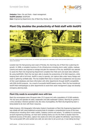
Daniel Bass, Engineering Inspector and Zlatko Knezevic, GIS Coordinator (right) capturing storm water outlets, roadway culverts and sewer locations from a
distance with ikeGPS205.
Located near the fast-growing west coast of Florida, the charming city of Plant City is planning for
growth. In 2008, a complete inventory of city infrastructure including storm water outlets, roadway
culverts and sewers was required to manage and plan the extension of the city. ikeGPS205 was selected
to assist the Plant City Engineering Department complete their field work and asset data collection.
By using ikeGPS205, Plant City has been able to double the productivity of its field inspectors, while
keeping them safe at all times. ikeGPS is easy to operate, can capture data under heavy foliage and
assist in gathering verifiable data. This has enabled Plant City to increase the completeness and accuracy
of their asset databases and share information with other departments through ikeGPS compatibility
with ESRI ArcGIS products. As a result of successful ikeGPS-based surveys, Plant City has transferred
ikeGPS field methodologies to other departments to assist their asset management usage and develop
emergency planning tools.
Plant City needs to accomplish more with less
Plant City encompasses some 28 square miles (72.5 square km) with a population of 33,500 residents.
The city owns and operates its water, wastewater and solid wastewater systems. Planning for growth is
a time and labour intensive operation and, like many municipalities, the Plant City Engineering team is
being tasked to do more with fewer resources.
Zlatko Knezevic, GIS (Geographic Information System) Coordinator at Plant City Engineering Department
was initially left with using traditional surveying tools to complete a comprehensive survey of the town
infrastructure including storm water outlets, roadway culverts and sewers. “In addition to converting
as-built engineering drawings, we have been sending teams out into the field to double-check the
positional accuracy of the plans, capture new assets and verify and update the attributes,” says Knezevic.
“Our survey-grade GPS units worked very well, but were slow to set up and use. It was taking too long.”
ikeGPS website - CS Plant City Final Ex Comments 1|4 January 2011
2. Surveylab Case Study
Knezevic also said that although the GPS handheld units used at Plant City were of high positional accuracy,
this feature wasn’t needed for the survey at hand. Additionally, these devices lost the GPS signal under the
trees. “So we were looking for a faster data capture solution that would satisfy our requirements without
breaking the bank”, acknowledged Knezevic. The new solution also had to be compatible with ESRI’s
ArcGIS products to facilitate the integration of field data in the Plant City GIS databases.
At the 2008 ESRI user conference, City Engineer Brett Gocka P.E. and Knezevic discovered the ikeGPS
products at the Surveylab booth. They were fascinated. “From what we saw,” continues Knezevic, “the
ikeGPS205 was in a class of its own. In fact we didn’t see any other GPS units with those capabilities at
the show... or since. We liked the size, the ease-of-use, features, knowledgeable staff and especially the
integration with ESRI’s ArcPad software. To us, there are conventional GPS [data] collectors and then
there is ikeGPS.” The decision was easy to make and an ikeGSP205 unit was purchased immediately
at the conference.
Doubling the productivity with consistent data capture quality
With Surveylab’s ikeGPS205 handheld data collection system, the Engineering Department of Plant City
has now doubled the productivity of field inspectors.
“Only one inspector is needed to operate the ikeGPS205 unit in the field, whereas with the other tools
at our disposal at least two people were required”, proudly confirms Knezevic. “Now we have twice the
productivity without any decrease in the quality of data capture. In fact, because ikeGPS205 can be used
to capture multiple assets from a single location using the laser range finder, one single inspector can
work more than twice as fast than a two-man team with tripod-based GPS.”
Plant City field surveys are completed faster while their database completeness and accuracy
proportionally increased. All this with less material and human resources required for the work at hand.
Safe and verifiable field data capture from a remote location
“Not only does the ikeGPS help us capture more data in a shorter timeframe, but it is much safer for
our team,” adds Knezevic. “With ikeGPS’s unique laser range finder, our field inspectors can stay by the
roadside or in an open area and capture asset data without having to stand in a busy street, wade in
storm water drainage ditches or climb steep banks”.
In addition, Plant City contains extensive woodlands with heavy foliage that, in the past, have made GPS
reception problematic. “But with the ikeGPS unit, we can stand in an open area, point the ikeGPS at an
asset located under the trees and capture the attributes quickly and easily,” supports Knezevic.
Easy to use integrated ikeGPS units
Knezevic confirms that setting up the ikeGPS205 unit for required data collection was extremely easy.
“We created a basic shapefile layer in ArcGIS and then loaded it into the ikeGPS205. We then created
a basic form with ArcPad and sent our inspectors out into the field to collect data and fill out the
form with some basic information and notes [on the assets targeted]. Once they were back at the
office we downloaded the data directly into the workstation.” This methodology makes it simple and
ikeGPS website - CS Plant City Final Ex Comments 2|4 January 2011
3. Surveylab Case Study
straightforward to double-check the positional accuracy of engineering plans, capture new assets and
verify and update the attributes stored in a main database.
The unit set-up was so easy, in fact, that it took only a half-hour to show the inspectors how to use the
ikeGPS205. “Our inspectors are very knowledgeable about the assets in the field and the attributes that
we were trying to capture,” continues Knezevic, “but they are not GIS people. So having very simple to
operate field units was a definite bonus”.
Knezevic is also impressed with the ikeGPS205’s robustness. “We take it out in the wind and rain,
and even drop it on occasion,” he says. “But through all that, it works without any issues whatsoever.
When you send a unit out into the field, you want to be able to rely on it. The ikeGPS delivers.”
Multi-divisional, data sharing and emergency management potential
As of July 2010, the Plant City Engineering Department was nearing completion of their initial asset
capture exercise. “Right now we’re almost finished with the storm water outlets, roadway culverts and
sewers,” says Knezevic, “and are trialling ikeGPS systems for creating inventories and re-establishing
records for streetlights, signposts, traffic signals and intersection signage. The Traffic Department has
also expressed an interest in using our ikeGPS205 to help them complete their inventories.”
The data captured by the ikeGPS205 unit is being made available to taxpayers and property owners
in Plant City. “One of our initiatives,” concludes Knezevic, “is to open our datasets to the public via
the internet. This will help people see exactly where the assets are in their neighborhoods.”
“We have also been using the data in our on-going negotiations with the Federal Emergency Management
Agency (FEMA) to help develop more accurate flood plain maps. In this case, placing land parcels in the
wrong flood plain designation can result in unnecessary flood insurance that can significantly lower land
values, cost homeowners extra and, ultimately, reduce Plant City revenues. But with ikeGPS, we can
capture accurate and up-to-date
information quickly and feed
it directly into our mapping
systems. ikeGPS is clearly
in a class by itself,”
confirms Knezevic.
Geo-positional information and photos of
a Plant City culvert (a), storm water drain
(b) and bridge (c) are validating the state (a) (b)
and condition of Plant City storm water
infrastructures. The data is subsequently
imported in the Plant City ArcGIS mapping
system and shown in a city map along with
other engineering data layers (d) for further
analysis and cataloguing.
(c) (d)
ikeGPS website - CS Plant City Final Ex Comments 3|4 January 2011
4. Surveylab Case Study
AT A GLANCE
Key reasons Plant City selected the ikeGPS205 unit
• Fast data capture solution that could capture data under foliage
• Ease-of-use and integrated features into a single handheld rugged device
• Laser rangefinder allowing data capture from a distance
• Compatibility with ESRI’s ArcGIS and ArcPad
• Knowledgeable staff and expert support
Key benefits for Plant City
• Fast data collection system: at least doubles productivity for field inspection staff
• Much safer and easier to operate in the field than traditional tripod-based GPS units
• Verifiable data capture to quickly cross-check information, increase completeness and accuracy
of their other mapping databases
• Robust device that can be used under heavy foliage
• Cross-functional and multi-divisional uses across Plant City departments
Technology used
• ikeGPS205 series GPS data collection unit from Surveylab
• ArcGIS 9.5 (or ArcGIS 10)
• ArcPad Mobile GIS software
Customer quote:
“Because the ike205 can be used to capture multiple assets from a single location using the laser
rangefinder, one single inspector can work more than twice as fast as a two-man team with tri-pod
based GPS.”.
- Zlatko Knezevic GIS Coordinator for the Engineering Division at Plant City
For more information please contact:
Richard Taylor
Vice President - ikeGPS Americas
richard.taylor@ikegps.com
office: (281) 681 0356
fax: (281) 681 9252
www.ikeGPS.com
ikeGPS website - CS Plant City Final Ex Comments 4|4 January 2011

![Surveylab Case Study
Knezevic also said that although the GPS handheld units used at Plant City were of high positional accuracy,
this feature wasn’t needed for the survey at hand. Additionally, these devices lost the GPS signal under the
trees. “So we were looking for a faster data capture solution that would satisfy our requirements without
breaking the bank”, acknowledged Knezevic. The new solution also had to be compatible with ESRI’s
ArcGIS products to facilitate the integration of field data in the Plant City GIS databases.
At the 2008 ESRI user conference, City Engineer Brett Gocka P.E. and Knezevic discovered the ikeGPS
products at the Surveylab booth. They were fascinated. “From what we saw,” continues Knezevic, “the
ikeGPS205 was in a class of its own. In fact we didn’t see any other GPS units with those capabilities at
the show... or since. We liked the size, the ease-of-use, features, knowledgeable staff and especially the
integration with ESRI’s ArcPad software. To us, there are conventional GPS [data] collectors and then
there is ikeGPS.” The decision was easy to make and an ikeGSP205 unit was purchased immediately
at the conference.
Doubling the productivity with consistent data capture quality
With Surveylab’s ikeGPS205 handheld data collection system, the Engineering Department of Plant City
has now doubled the productivity of field inspectors.
“Only one inspector is needed to operate the ikeGPS205 unit in the field, whereas with the other tools
at our disposal at least two people were required”, proudly confirms Knezevic. “Now we have twice the
productivity without any decrease in the quality of data capture. In fact, because ikeGPS205 can be used
to capture multiple assets from a single location using the laser range finder, one single inspector can
work more than twice as fast than a two-man team with tripod-based GPS.”
Plant City field surveys are completed faster while their database completeness and accuracy
proportionally increased. All this with less material and human resources required for the work at hand.
Safe and verifiable field data capture from a remote location
“Not only does the ikeGPS help us capture more data in a shorter timeframe, but it is much safer for
our team,” adds Knezevic. “With ikeGPS’s unique laser range finder, our field inspectors can stay by the
roadside or in an open area and capture asset data without having to stand in a busy street, wade in
storm water drainage ditches or climb steep banks”.
In addition, Plant City contains extensive woodlands with heavy foliage that, in the past, have made GPS
reception problematic. “But with the ikeGPS unit, we can stand in an open area, point the ikeGPS at an
asset located under the trees and capture the attributes quickly and easily,” supports Knezevic.
Easy to use integrated ikeGPS units
Knezevic confirms that setting up the ikeGPS205 unit for required data collection was extremely easy.
“We created a basic shapefile layer in ArcGIS and then loaded it into the ikeGPS205. We then created
a basic form with ArcPad and sent our inspectors out into the field to collect data and fill out the
form with some basic information and notes [on the assets targeted]. Once they were back at the
office we downloaded the data directly into the workstation.” This methodology makes it simple and
ikeGPS website - CS Plant City Final Ex Comments 2|4 January 2011](data:image/gif;base64,R0lGODlhAQABAIAAAAAAAP///yH5BAEAAAAALAAAAAABAAEAAAIBRAA7)