Desert Locust Information System
•
0 gefällt mir•36 views

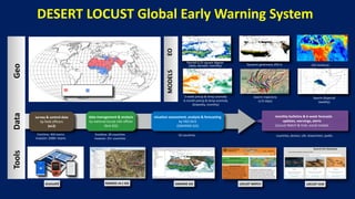
The document describes the Desert Locust Global Early Warning System which uses Rv4 GIS software and SWARMS GIS to collect and analyze locust survey and control data from over 50 countries. The system provides monthly bulletins, 6-week forecasts, updates, warnings and alerts. It utilizes data on rainfall, greenness, precipitation anomalies, temperature anomalies and soil moisture from various sources. Models in the eLocust3 platform analyze the data to generate 15-day swarm trajectory forecasts and weekly swarm dispersal forecasts. Over 400 teams monitor locust activities during recessions and over 2000 teams respond during invasions.
Empfohlen

Empfohlen
Weitere ähnliche Inhalte
Ähnlich wie Desert Locust Information System
Ähnlich wie Desert Locust Information System (20)
Mehr von Global Landscapes Forum (GLF)
Mehr von Global Landscapes Forum (GLF) (20)
Kürzlich hochgeladen
Kürzlich hochgeladen (20)
Desert Locust Information System
- 1. 1988 1954 RAMSES v4.1 GIS SWARMS GIS data management & analysis by national locust info officer (Rv4 GIS) monthly bulletins & 6-week forecasts updates, warnings, alerts (Locust Watch & Hub; social media) frontline: 400 teams invasion: 2000+ teams frontline: 20 countries invasion: 25+ countries 50 countries countries, donors, UN, researchers, public Data Tools Geo Rainfall 0.25 square degree (daily, decadal, monthly) Dynamic greenness 250 m (decadal) 2-week precip & temp anomaly 6-month precip & temp anomaly (biweekly, monthly) eLocust3 MODELS EO survey & control data by field officers (eL3) Swarm trajectory (±15 days) Swarm dispersal (weekly) Soil moisture (decadal) LOCUST HUB LOCUST WATCH DESERT LOCUST Global Early Warning System situation assessment, analysis & forecasting by FAO DLIS (SWARMS GIS)