2015 FOSS4G Track: Developing, Exploring, and Utilizing a National Web-Based Forest Carbon Application by Ian Hanou

The USFS Forest Inventory and Analysis (FIA) program provides a systematic protocol for forest field data collection to serve as the census for forest information and support proper management. This wealth of data has been analyzed to provide wall-to-wall spatial GIS coverage of forest carbon estimates across the lower 48 U.S. states to support Greenhouse Gas (GHG) inventory. Through a research agreement and collaboration with the University of Minnesota (UMN), this project provided a 21st century “digital experience and distribution” of the Forest Carbon Estimation in the FIA program rather than static maps and tables by developing an online, mobile/web browser map application (app). This web and mobile software tool enables the public to learn about carbon and how much is stored in a nearby forest. The data is presented to the user interactively on a map along with charts, graphs, and links to related resources. The intended audience is anyone interested in exploring forest carbon information. The tool is a web browser map application for smartphones, tablets, and desktop use. It primarily works online but also offline with simplified functionality. This provides any range of users with access to the carbon summaries in the field and at the desk. The app also provides education links to NFS carbon assessment whitepapers and FIA protocols. Join this session to learn about the development of this exciting new database and app and how to explore carbon in forests near you or nationally.

Empfohlen
Empfohlen
Weitere ähnliche Inhalte
Was ist angesagt?
Was ist angesagt? (20)
Andere mochten auch
Andere mochten auch (16)
Ähnlich wie 2015 FOSS4G Track: Developing, Exploring, and Utilizing a National Web-Based Forest Carbon Application by Ian Hanou
Ähnlich wie 2015 FOSS4G Track: Developing, Exploring, and Utilizing a National Web-Based Forest Carbon Application by Ian Hanou (20)
Mehr von GIS in the Rockies
Mehr von GIS in the Rockies (20)
Kürzlich hochgeladen
Kürzlich hochgeladen (20)
2015 FOSS4G Track: Developing, Exploring, and Utilizing a National Web-Based Forest Carbon Application by Ian Hanou
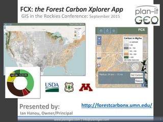
- 1. FCX: the Forest Carbon Xplorer App GIS in the Rockies Conference: September 2015 1 Ian Hanou, Owner/Principal Presented by: www.planitgeo.com | info@planitgeo.com 1 http://forestcarbonx.umn.edu/
- 2. Tree Plotter® Canopy Planner® Park Plotter® Work Order Management® Native Apps Browser-based for tablets or desktop No GIS or GPS software needed; hosted solution Real-time, multi-user data entry on-the-cloud Custom Apps 2www.planitgeo.com | info@planitgeo.com Agenda Meet our Staff Our Services and Projects Project Understand ing Project Approach Timeline / Milestones Questions AgendaIntroduction Background Technologies Get Carbon Reports & Values What’s Next? Questions & Credits Introduction Plan-It Geo Software Overview
- 3. Funding from USFS and Univ. of Minnesota A simple app for smartphones, tablets, and desktop use to explore the extent and value of the nation’s forest carbon, a 21st Century “Digital Experience” Methods: by GPS location, by county (in map), by county (in tables), and by radius (draw in map) Outputs: charts, graphs, and tables of carbon pools (tonnes/$s) Resources: Forestry Research: http://www.cbmjournal.com/content/8/1/1 Data: http://www.fs.usda.gov/rds/archive/Product/RDS-2013-0004 EPA GHG Equivalencies Calculator Interagency Working Group on Social Cost of Carbon (2013) State of CA Air Resources Board http://www.fia.fs.fed.us/ 3www.planitgeo.com | info@planitgeo.com Agenda Meet our Staff Our Services and Projects Project Understand ing Project Approach Timeline / Milestones Questions Agenda Introduction Background Technologies Get Carbon Reports & Values What’s Next? Questions & Credits Background Project Background
- 4. USFS Forest Inventory and Analysis (FIA): systematic inventory of forests for primary source of national statistics and supports informed forest management Data analyzed to provide wall-to-wall spatial GIS rasters of forest carbon estimates by pool (lower 48 states) 4www.planitgeo.com | info@planitgeo.com Agenda Meet our Staff Our Services and Projects Project Understand ing Project Approach Timeline / Milestones Questions Agenda Introduction Background Technologies Get Carbon Reports & Values What’s Next? Questions & Credits Background About the Data
- 5. 6 individual carbon “pools” and total (7 rasters), 250m res. 5www.planitgeo.com | info@planitgeo.com Agenda Meet our Staff Our Services and Projects Project Understand ing Project Approach Timeline / Milestones Questions Agenda Introduction Background Technologies Get Carbon Reports & Values What’s Next? Questions & Credits Background About the Data
- 6. Technologies and Requirements •Web browser-based Web connection required Some offline capability No download/install • Technologies: Open Layers API PostgreSQL / PostGIS GeoServer Responsive JS libraries Red Hat Linux HTML5, CSS, etc. www.planitgeo.com | info@planitgeo.com 6 Agenda Meet our Staff Our Services and Projects Project Understand ing Project Approach Timeline / Milestones Questions Agenda Introduction Background Technologies Get Carbon Reports & Values What’s Next? Questions & Credits Technologies
- 7. “Get Carbon” •Methods: Wizard By GPS location By county (in map) By county (in tables) By radius (draw in map) www.planitgeo.com | info@planitgeo.com 7 Agenda Meet our Staff Our Services and Projects Project Understand ing Project Approach Timeline / Milestones Questions Agenda Introduction Background Technologies Get Carbon Reports & Values What’s Next? Questions & Credits Get Carbon
- 8. “Get Carbon” (via the Wizard) www.planitgeo.com | info@planitgeo.com 8 Agenda Meet our Staff Our Services and Projects Project Understand ing Project Approach Timeline / Milestones Questions Agenda Introduction Background Technologies Get Carbon Reports & Values What’s Next? Questions & Credits Get Carbon
- 9. “Get Carbon” (by GPS location) www.planitgeo.com | info@planitgeo.com 9 Agenda Meet our Staff Our Services and Projects Project Understand ing Project Approach Timeline / Milestones Questions Agenda Introduction Background Technologies Get Carbon Reports & Values What’s Next? Questions & Credits Get Carbon
- 10. “Get Carbon” (by County in map) www.planitgeo.com | info@planitgeo.com 10 Agenda Meet our Staff Our Services and Projects Project Understand ing Project Approach Timeline / Milestones Questions Agenda Introduction Background Technologies Get Carbon Reports & Values What’s Next? Questions & Credits Get Carbon
- 11. “Get Carbon” (draw radius in map) www.planitgeo.com | info@planitgeo.com 11 Agenda Meet our Staff Our Services and Projects Project Understand ing Project Approach Timeline / Milestones Questions Agenda Introduction Background Technologies Get Carbon Reports & Values What’s Next? Questions & Credits Get Carbon
- 12. Reported Carbon Values ($) www.planitgeo.com | info@planitgeo.com 12 Agenda Meet our Staff Our Services and Projects Project Understand ing Project Approach Timeline / Milestones Questions Agenda Introduction Background Technologies Get Carbon Reports & Values What’s Next? Questions & Credits Reports & Values
- 13. Reported Carbon Values ($) www.planitgeo.com | info@planitgeo.com 13 Agenda Meet our Staff Our Services and Projects Project Understand ing Project Approach Timeline / Milestones Questions Agenda Introduction Background Technologies Get Carbon Reports & Values What’s Next? Questions & Credits Reports & Values
- 14. Reported Carbon Values (“Equivalents”) www.planitgeo.com | info@planitgeo.com 14 Agenda Meet our Staff Our Services and Projects Project Understand ing Project Approach Timeline / Milestones Questions Agenda Introduction Background Technologies Get Carbon Reports & Values What’s Next? Questions & Credits Reports & Values
- 15. Where to Now? • Export/save/print forest carbon reports • Separate rasters for each carbon pool • Many other forest metrics from FIA could be in focused apps • NASA Carbon Monitoring System Workshop, JPL, Pasadena, CA (Nov. 2015) • Xplore … Go “Get Carbon”! www.planitgeo.com | info@planitgeo.com 15 Agenda Meet our Staff Our Services and Projects Project Understand ing Project Approach Timeline / Milestones Questions Agenda Introduction Background Technologies Get Carbon Reports & Values What’s Next? Questions & Credits What’s Next?
- 16. Questions & Acknowledgements www.planitgeo.com | info@planitgeo.com 16 Agenda Meet our Staff Our Services and Projects Project Understand ing Project Approach Timeline / Milestones Questions Agenda Introduction Background Technologies Get Carbon Reports & Values What’s Next? Questions & Credits Q’s and Credits Questions? Credits: Chris Woodall, Research Forester, US Forest Service R&D (651) 649-5141 | cwoodall@fs.fed.us Matt Russell, University of Minnesota (612) 626 4280| russellm@umn.edu
- 17. Thank you! Ian Hanou, Owner and Director, Business Development (303) 503-4846 | IanHanou@PlanItGeo.com A geospatial analysis, technology consulting, and planning firm specializing in urban natural resource management. Info@PlanItGeo.com www.planitgeo.com 17