GEOtop-GEOFRAMEPosterAtCHyMP meeting 2009
•
0 gefällt mir•165 views

Poster presented at the CHyMP meeting of Memphis, March31- April 1 2009
Empfohlen

Empfohlen
Weitere ähnliche Inhalte
Andere mochten auch
Mehr von Riccardo Rigon
Mehr von Riccardo Rigon (20)
Kürzlich hochgeladen
Kürzlich hochgeladen (20)
GEOtop-GEOFRAMEPosterAtCHyMP meeting 2009
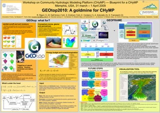
- 1. Workshop on Community Hydrologic Modeling Platform (CHyMP) — Blueprint for a CHyMP Memphis, USA, 31 march – 1 April 2009 GEOtop2010: A goldmine for CHyMP R. Rigon (1), M. Dall’Amico (1)(2), S. Endrizzi (1)(4), E. Cordano (1), A. Antonello (3), S. Franceschi (3) Università di Trento, Via Mesiano77, Trento (Italy) (riccardo.rigon@ing.unitn.it), (2) Mountain-eering s.r.l., via Siemens 19, Bolzano (Italy), (3) HydroloGIS s.r.l., via Siemens 19, Bolzano (Italy), (4) Centre of Hydrology, University of Saskatchewan, Saskatoon, Canada GEOFRAME GEOtop: what for? + rainfall-runoff and soil moisture Cryosphere (snow, glacier + and permafrost) - GEOtop (www.geotop.org) is a distributed and physically- based model which runs on a 3D grid built on complex -GEOtop snow model works with a multilayer + topography scheme, capable of describing snow = metamorphism and water circulation and - computes the energy budget and the 3D water balance refreezing in the snowpack; originating from snow and ice melt, infiltration, soil moisture evolution and matric suction within a basin - soil freezing/thawing is accounted and + + allows to simulate permafrost areas. + • Development and extension of the JConsole engine for automatic OpenMI based model linking and execution within the framework of Jgrass. • Development of a set of tools to load external models based on the OpenMI courtesy of Stephan Gruber standards without any additional programming into the running JGrass application and further execution of the model; • Design and implementation of a graphical user interface for enhanced and user- friendly import and linking of models, based on the Graphical Editing Framework Energy budget and evapotranspiration and possibly Eclipse Modeling Framework technologies. • Creation and packaging of a customized integrated development environment Effect of ET elevation based on the Eclipse IDE extended with GIS capabilities and OpenMI extension points, that should support project partners that are interested in model migration Effect of aspect to get started in OpenMI besed development N/S Effect of soil thickness Effect of Centralized archival of environmental data, both spatial and non spatial, retrieval of all involved data from remote and local data sources, validation topographic of the incoming data, temporal interpolation for filling gaps of missing data, exposure of a service towards modeling applications (JGrass), spatial convergence Triggering of natural data analysis through an embedded subset of the JGrass framework (wetland) hazards (shallow 84 96 108 120 W/m2 0 12 24 36 48 60 72 FUTURE STEPS Effect of land use landslides and debris VISUALIZATION TOOL (lake) Rn + P − H − L − G = 0 flow) First Steps into GEOFRAME: First Componentization 3D visualization module in JGrass based on Nasa World Wind dedicated to the visualization of suitable input and output data of the models Meteo Energy Water - Stability analysis incorporates the dynamic description of soil - GEOtop calculates the radiation forcing Rn and solves the turbolence in I/O + + + moisture and tackles the heterogeneity of soil mechanical properties Forcing budget Budget the ABL to calculate the heat gained or lost by the soil; through a probabilistic approach; - H and L are calculated according to the vegetation type and fraction in a - one can map the failure probability for a given area, and also pixel, in order to derive the evapotranspiration in the catchment € estimate sediment volume available for failure. First Steps into GEOFRAME: Second Componentization What’s under the hood Input Meteo Water Energy I/O + + + Forcing Budget budget Point (profiles) and distributed (maps) : Temperature, water content, ice CT ∂T − ρi Lf ∂θi + ρw cw Jw (ψT ) • T+ • G + Sen = 0 content, pore water pressure, snow height, snow density, glacier height, ∂t ∂t (2) glacier density, surface energy fluxes (G, H, L, TE, Rn), water discharge Further splitting will follow at an outlet θw (ψT ) ρi ∂θi + + • Jw (ψT ) + Sw = 0 ∂t ρw ∂t Data Subsurface Surface Output I/O Assimilation Flows Flows Maps: DTM, land use map, topographical features, channel network, drainage directions, soil type Snow / Vegetation I/O Radiation Parameters: soil hydraulic properties,thermal proprties, geothermal heat glacier flux, surface properties, vegetation Meteo: Rainfall, Wind Speed, Air Temperature, Relative Humidity, SW References Bertoldi, G., R. Rigon & T. M. Over, Impact of watershed geomorphic characteristics on the energy and water budgets, Jour. of Hydromet., Vol. 7, No. 3, p. 371- 388. Vol. 7, No. 3, pages 389 - 394, 2006. Beam and Diffusive Radiation, Lapse Rate Bertoldi G., Dietrich W.E., Miller N. L., Rigon R.. Bedrock and soil contribution to the formation of sub-surface runoff by saturation in headwater catchments: observations and simulation using a distributed hydrological model, Atti del XXIX Convegno di Idraulica e Costruzioni Idrauliche, Trento, Settembre 2004. A detailed descrition of necessary input data of GEOtop is available in the Bertoldi G., Notarnicola C., Leitinger G., Zebisch M., and Tappeiner U. (in preparation) Morphological and eco-hydrological controls on land surface temperature in an Alpine catchment Bertoldi G., Wohlfahrt G., Della Chiesa S.,Tappeiner U., Endrizzi S. (in preparation): Biotic and a-biotic controls on energy and water partitioning in a mountain grassland documentation page at www.geotop.org. Further input meteorological Lanni C., Tarantino A., Cordano E., Rigon R., 2009: Analysis of the effect of normal and lateral subsurface water flow on the triggering of shallow landslides with a distributed hydrological modelquot; - International Conference quot;Landslides Processesquot; ,Strasbourg, France data can be requested if GEOtop is coupled with MicroMet. Rigon R., Bertoldi G e T. M. Over, GEOtop: A distributed hydrological model with coupled water and energy budgets, Jour. of Hydromet., Vol. 7, No. 3, pages 371- 388., Vol. 7, No. 3, pages 371-388. Simoni, S., F. Zanotti, G. Bertoldi and R. Rigon, Modelling the probability of occurrence of shallow landslides and channelized debris flows using GEOtop-FS, accepted for Hydrol. Proc., published on-line, Dec 2007 Zanotti F, Endrizzi S, Bertoldi G, Rigon R. 2004. The GEOTOP snow module. Hydrological Processes 18: 3667–3679. DOI:10/1002/hyp.5794.