SlideShare ist ein Scribd-Unternehmen logo
1 von 36
Downloaden Sie, um offline zu lesen
Up-to-date observations of water quality conditions in Puget Sound and coastal bays
Surface Conditions Report: March 16, 2020
Eyes Over Puget Sound
Publication No. 20-03-071
Summary Stories Diving & critters Climate & streams Combined factors Marine water Aerial photos Info
Critter of the month: The humpback shrimp
The kelp Humpback shrimp p. 4
The kelp humpback shrimp is a master of camouflage.
Water visibility for divers p. 5
Now would be the time to go diving, the water is clear.
Climate & streams p. 6-10
After a wet January, precipitation currently is low. Most of the
winter has been normal but currently its cooler. As a result rivers
presently run lower than expected. Rivers in general have been
flowing low since last year.
Water temperature and food web p. 12
While low temperatures allow herring to spawn, we are now in
March approaching the survival threshold for anchovies, around 8
°C.
Aerial photography p. 13-29
First spring blooms develop in response to sunnier conditions and
stain the water of finger inlets in South Sound green. Jellyfish
patches are numerous only in Eld Inlet. Herring are reported to be
spawning in the northern regions of Puget Sound, but not yet in
South Sound. Northerly winds and waves resuspended sediment in
exposed north-facing beaches of South Sound.
LONG-TERM
MARINE
ITORING
UNIT
Editorial assistance provided by: Elisa Rauschl, Julianne Ruffner, Valerie Partridge.
Summary conditions at a glance
Summary Stories Diving & critters Climate & streams Combined factors Marine water Aerial photos Info
Skip Albertson
Dr. Christopher
Krembs (Editor)
Tyler Burks
Jeff Marti
Dany Burgess
Angela Eagleston
Above: I sort invertebrates into phyla
Below: I filter water samples for chlorophyll-a
My name is Tyler Ransier, and I am the marine monitoring intern for the year of 2020. Although I’ve only been a part of
the MMU team for five months now, I have gotten the opportunity to assist with a huge variety of exceptional projects,
programs and people. Here is a snapshot of some of the awesome work I’ve been helping out with so far!
Above: I help collect water samples using a CTD
Below: We also collect CTD data via float plane
My Experience so far as the Marine Monitoring Intern with the MMU
Tyler Ransier – Washington Conservation Corps Intern
Personal Field Impression
Summary Stories Diving & critters Climate & streams Combined factors Marine water Aerial photos Info
Personal Field Impression 3-16-2020
Critter of the month – The Kelp Humpback Shrimp
Dany Burgess
Marine Sediment monitoring Team
Kelp Humpback Shrimp Facts
• Important food source for
juvenile rockfish and other
predators
• May be distinguished from similar
species by counting the tiny
points at the end of its “snout”
Hippolytes clarki
The kelp humpback shrimp is a
master of camouflage – with its
green or brown color, it blends in
perfectly with its eelgrass (or kelp)
home. It may be tiny, but it is a big
player in the Puget Sound food web!
Image by Dave Cowles,
wallawalla.edu
Image by Aaron Baldwin,
Alaska Dept of Fish and Game
Summary Stories Diving & critters Climate & streams Combined factors Marine water Aerial photos Info
Eyes Under Puget Sound 3-16-2020
Learn more about the kelp humpback shrimp and other critters on Ecology’s EcoConnect blog here
Best and poor horizontal visibility
at corresponding vertical depth
Good Poor
Visibility
(only best visibility shown)
Find depths with high/low
visibility
• Best visibility occurred in Hood
Canal near Octopus Hole
(location 11), with almost 40 ft
visibility at about 90 ft depth.
• Poor visibility (no diver icon)
occurred near the surface in
Mukilteo (location 6) and in
Oakland Bay near Shelton
(location 14).
• Explaination: “Underwater
Visibility Maps — a Tool for Scuba
Divers,” is available here.
February: Imagine you can better
see the diver underwater water at
good visibility, darker contour.
Location
Best Visibility Worst Visibility
Horizontal
Distance
(ft.)
Vertical
Depth
(ft.)
Horizontal
Distance
(ft.)
Vertical
Depth
(ft.)
1 15 49 14 5
2 11 44 7 7
3 -2 3 15 34
4 22 38 10 5
5 16 3 16 97
6 20 46 5 3
7 18 46 7 11
8 21 95 13 8
9 22 39 11 5
10 17 10 11 48
11 37 90 13 11
12 22 69 19 20
13 22 98 10 11
14 5 5 5 23
15 12 43 8 7
16 13 7 10 44
17 12 21 8 51
What was the water visibility like for divers?
Personal Field Impression
Summary Stories Diving & critters Climate & streams Combined factors Marine water Aerial photos Info
What can you find underwater?
How much water did we get and what can we expect?
Summary Stories Diving & critters Climate & streams Combined factors Marine water Aerial photos Info
In March, Puget Sound air temperatures were below normal while precipitation was near to below
normal (A). Nearing the seasonal peak of snowpack accumulation, watersheds that drain to Puget Sound
hold near-normal volumes (B). Monitoring snowmelt rates and timing will be critical as we transition to
spring and summer. Will trends in early snowmelt runoff peaks continue?
A. Northwest Climate Toolbox B. Washington SNOTEL, USDA/NRCS
Temperature Anomaly
from historical mean daily
ranged from +1 to -4 °F in
the Puget Sound region
during the past 30 days.
Precipitation Anomaly
from historical mean
ranged from 0 to -12 inches
in the Puget Sound region
during the past 30 days.
Snow water equivalent percent of median for watersheds
draining to Puget Sound are just above normal. Nearing
the typical peak of seasonal snowpack accumulation,
April 1st, snow water equivalents are at 109% of the
historical median.
March 26th, 2020
Temperature Precipitation
Daily
average
discharge,
in
cubic
feet
per
second
Select Puget Sound Streamflow Trends
Daily
average
discharge,
in
cubic
feet
per
second
Current Streamflow Conditions as of 3/26/2020
Current conditions: CLICK HERE!
USGS WaterWatch: CLICK HERE!
Skagit River near Mt. Vernon
(12200500)
Snohomish River near roe
(12150800)
How much water flows into Puget Sound?
Summary Stories Diving & critters Climate & streams Combined factors Marine water Aerial photos Info
Cool and dry conditions during March have resulted in below normal flows in larger, snow-dominated
watersheds (see trend charts). Most stream gages are reporting normal to far-below-normal flows,
especially those that are in rain-dominated watersheds (see map). With a normal snowpack this year,
temperature will be the main driver of a sustained freshwater supply to Puget Sound.
How much water did we get and what can we expect?
Summary Stories Diving & critters Climate & streams Combined factors Marine water Aerial photos Info
Statewide snowpack measured 109 percent of normal on April 1st. This is a tremendous
comeback from where it was on January 1st: 50 percent of normal. Ample snowpack at higher
elevations means that mainstream rivers like the Skagit, Nooksack, Snohomish, Stillaguamish in
snowpack-dominated basins are forecasted to experience normal to above normal runoff from
April through September.
Snowpack fed basins are in good
shape, but lower elevation
basins and non-snowpack fed
tributaries need precipitation.
Many rain-dominated, lower-
elevation basins – like the
Chehalis -- are forecasted to
experience below-normal runoff
from April to September. This
includes the Samish, Deschutes,
Skokomish, Dungeness, Elwha
and Wynoochee Rivers.
Climate :How wellis the Salish Sea exchanging its water?
The Fraser River is the major driver of
estuarine circulation and water
exchange between the Salish Sea and
the ocean. The Fraser River has
regained expected levels. The
Canadian snow basin index for the
Fraser River is at 117%, predicting a
strong freshet — click here
Historically, the peaks of coastal upwelling and the freshet are in sync. In early 2020 Fraser R. flows are expected.
NPGO
(x10)
PDO/Upwelling
Index
How do ocean boundary conditions
affect the quality of water we
exchange with the ocean?
Recent years’ warm water is mostly
gone (PDO). Upwelling (Upwelling
Index anomaly) is relative expected.
NPGO, which reflects the surface
productivity along the coast, has not
been updated since July 2019.
Pacific Decadal Oscillation Index (PDO, temperature, explanation). Upwelling Index (anomalies) (Upwelling, low
oxygen, explanation). North Pacific Gyre Oscillation Index (NPGO, productivity, explanation).
Three-year running average of PDO, Upwelling, and NPGO Indices
Summary Stories Diving & critters Climate & streams Combined factors Marine water Aerial photos Info
Fraser River (at midnight)
Higher than normal
Lower than normal
Expected
Climate: How wellis Puget Sound exchanging its water?
The Skagit River freshet is no longer
clearly pronounced, because it is a
regulated system. However, drought
years and low flows can be seen in the
river’s discharge data. Freshwater is an
important component determining the
stratification of surface water in Puget
Sound. Drought years weaken the
extent of stratification.
The Skagit River is the largest freshwater source for Puget Sound. It is a river that is regulated.
Summary Stries Diving & critters Climate & streams Combined factors Marine water Aerial photos Info
River flows and upwelling in the summer influence our water quality.
Rivers strengthen estuarine
circulation in the Salish Sea. This is
important in the summer.
Upwelled ocean water provides cool,
nutrient-rich water.
For that to happen, we need
northerly winds and good river flows
(a good snowpack) during periods of
water exchange through Admiralty
Reach (neap tides).
Normal river flows
drive “natural”
nutrient inputs and
keep the water
cool.
Low river flows
change the nutrient
balance and makes
water warmer.
Skagit River (at midnight)
Higher than normal
Lower than normal
Expected
higher No data
lower
expected
*Upwelling/downwelling Anomalies (PFEL)
PDO = Pacific Decadal Oscillation
ENSO = El Niño Southern Oscillation
All data are from public sources: UW GRAYSKIES; river
flows from USGS and Environment Canada; indices from
NOAA & UW (PDO).
2017 2018
What influences Puget Sound’s water quality?
Summary Stories Diving & critters Climate & streams Combined factors Marine water Aerial photos Info
In the anomaly plot, we want to connect different factors influencing water quality in the
context of space and time. Air temperatures in the past year have generally been warmer,
and the overall amount of rain has been low (note anomalies relative to a baseline in summer
over-emphasize a weak summer rain). 2020 fortunately started out with high precipitation,
and rivers are responding. For recent river and stream inflow, see pages 6-7.
Conditions leading up to March:
Air temperatures have been warmer
this winter, with a cold period only in
October.
Precipitation for fall was low, but
January was the 4th-wettest on record.
Sunshine (opposite of cloud cover) has
been cycling between higher and lower
values.
River flows have mostly been low since
last year, June 2018, but now regained
strength in some places.
Upwelling started to be less
predictable, as in the previous year.
Summary Stories Diving & critters Climate & streams Combined factors Marine water Aerial photos Info
Water temperature affects ecosystem performance
Warmer than expected
Cooler than expected
Expected 18-year average
Legend:
Can organisms
thrive and survive?
The life cycles of organisms
respond to temperature. To
be successful, the timing of
early life stages must line up
with good growth conditions.
Temperature is important for
growth, but also dictates if
certain organisms can
overwinter in Puget Sound
(e.g., northern anchovy).
* Help us get these right. We scoured the
literature for temperatures important to
the success and survival of marine
organisms.
Lifecycles
Temperature
Climate
In February, average surface water (0 – 30 m) temperatures were still slightly above
the baseline (1999 – 2018) across many regions. Water temperatures were in ranges
for spawning for herring, but gradually approaching the minimum survival
temperature for anchovies of about 8.2 °C. Coldest water temperatures currently
occur in Puget Sound right now, in March (data not available yet). Temperatures do
not reflect nearshore conditions that can be quite different.
Optimal temperatures for
Puget Sound organisms*
What are the conditions at the surface?
Start here
Bloom
Debris
Front
Plume
Narrow Hammersley Inlet connecting Oakland Bay
Mixing and fronts:
Tidal eddy off McNeil Island nicely visible through resuspended
nearshore sediment.
Debris:
Low levels restricted in South Sound to only Dana Passage.
Visible blooms:
First signs of a spring bloom developing in all Finger Inlets of
South Sound.
Jellyfish:
Numerous only in Eld Inlet but present in Totten and Budd
Inlets in few and small patches.
Suspended sediment:
Sediment suspended by waves on many beaches facing north.
Both ship traffic and shellfish-harvesting create local sediment
disturbances.
Summary Stories Diving & critters Climate & streams Combined factors Marine water Aerial photos Info
Large ships come all the way into South Sound.
The de Havilland Beaver float plane, a great workhorse.
Watch video
First spring blooms develop in response to sunnier conditions and stain the water of finger inlets in
South Sound green. Jellyfish patches are numerous only in Eld Inlet. Herring are reported to be
spawning in the northern regions of Puget Sound (click here), but not yet in South Sound. Northerly
winds and waves re-suspended sediment in exposed north-facing beaches of South Sound.
Flight
Strait of
Juan de Fuca
San Juan Islands
Main Basin
Hood Canal
Whidbey Basin
Sunny and hazy, moderate wind
south of Tacoma Narrows, >20 knots
winds out of the North past the
Tacoma Narrows.
Note: Flight route was changed due
to strong winds north of the Tacoma
Narrows.
Flight Observations
Aerial navigation guide
South Sound
Summary Stories Diving & critters Climate & streams Combined factors Marine water Aerial photos Info
Padilla Bay
Tide data from 3/16/2020 (Seattle):
Time Pred (ft) High/Low
05:11 AM 7.02 L
10:28 AM 10.26 H
05:37 PM 0.24 L
7
8
5
15
14
2
6
10 11
12
13
1 3
4
9
Strong
wind
No wind at the Port of Olympia. Little did we know that winds would pick up past the Tacoma Narrows.
Location: Port of Olympia, Budd Inlet (South Sound), 11:26 AM
1 Aerial photography 3-16-2020 Navigate
Summary Stories Diving & critters Climate & streams Combined factors Marine water Aerial photos Info
West Bay
Large ship approaching the Port of Olympia and stirring up sediment.
Location: Budd Inlet (South Sound), 11:27 AM
2 Navigate
Summary Stories Diving & critters Climate & streams Combined factors Marine water Aerial photos Info
Aerial photography 3-16-2020
ship
sediment
Priest Point Park
Water flowing past Boston Harbor reveals a spring bloom in Budd Inlet.
Location: Dana Passage (South Sound), 11:20 AM
3 Navigate
Summary Stories Diving & critters Climate & streams Combined factors Marine water Aerial photos Info
Aerial photography 3-16-2020
Bloom
Dofflemyer Point
Dover Point
Brisco Point
boat
South Sound has beautiful islands and waterways.
Location: Squaxin Island (South Sound), 11:22 AM
4 Navigate
Summary Stories Diving & critters Climate & streams Combined factors Marine water Aerial photos Info
Aerial photography 3-16-2020
Patches of jellyfish are present in Eld Inlet, but otherwise almost absent in other South Sound Inlets.
Location: Eld Inlet (South Sound), 11:32 AM
5 Navigate
Summary Stories Diving & critters Climate & streams Combined factors Marine water Aerial photos Info
Aerial photography 3-16-2020
jellyfish jellyfish
jellyfish
Sunrise Beach
Surface water in finger inlets of South Sound are stratified. A boat mixing the surface layer in Oyster Bay.
Location: Totten Inlet (South Sound), 11:35 AM
6 Navigate
Summary Stories Diving & critters Climate & streams Combined factors Marine water Aerial photos Info
Aerial photography 3-16-2020
Hurley Cove
boat
pens
plane shadow
7 Navigate
Summary Stories Diving & critters Climate & streams Combined factors Marine water Aerial photos Info
Aerial photography 3-16-2020
All finger inlets of South Sound have river inputs; like the Skookum Creek, most currently carry little sediment.
Location: Little Skookum Inlet (South Sound), 11:37 AM
Skookum River
Sediment resuspension by underwater shellfish extraction (see boat) and at wave-exposed beaches.
Location: McMciken Island, Case Inlet (South Sound), 11:47 AM
8 Navigate
Summary Stories Diving & critters Climate & streams Combined factors Marine water Aerial photos Info
Aerial photography 3-16-2020
Herron Island
boat
sediment
sediment
McMicken
Island
Sediment resuspension on wave-exposed beaches.
Location: Harstine Island, Case Inlet (South Sound), 11:48 AM
9 Navigate
Summary Stories Diving & critters Climate & streams Combined factors Marine water Aerial photos Info
Aerial photography 3-16-2020
Herron Island
sediment
sediment boat
Clear freshwater of the Skokomish entering Hood Canal at Union.
Location: Union (Hood Canal), 12:02 PM
10 Navigate
Summary Stories Diving & critters Climate & streams Combined factors Marine water Aerial photos Info
Aerial photography 3-16-2020
SkokomishRiver
Strong winds meet tidal current passing the Tacoma Narrows in opposite direction, causing high waves.
Location: Point Defiance (Central Sound), 12:20 PM
11 Navigate
Summary Stories Diving & critters Climate & streams Combined factors Marine water Aerial photos Info
Aerial photography 3-16-2020
Vashon Island
Point Defiance
Strong northerly winds cause sediment resuspension on wave-exposed north-facing beaches.
Location: Carr Inlet (South Sound), 12:25 PM
12 Navigate
Summary Stories Diving & critters Climate & streams Combined factors Marine water Aerial photos Info
Aerial photography 3-16-2020
South
Head
sediment
Resuspended sediment can travel along shore to be redeposited elsewhere.
Location: Carr Inlet (South Sound), 12:26 PM
13 Navigate
Summary Stories Diving & critters Climate & streams Combined factors Marine water Aerial photos Info
Aerial photography 3-16-2020
sediment
sediment
Resuspended sediment makes nearshore tidal eddies visible. A. looking north, B. looking south.
Location: Pitt Passage, McNeil Island Carr Inlet (South Sound), 12:28 PM
A. B.
14 Navigate
Summary Stories Diving & critters Climate & streams Combined factors Marine water Aerial photos Info
Aerial photography 3-16-2020
sediment
sediment
eddy
eddy
plane shadow
Spring bloom in Henderson Inlet has started. A. Looking West, B. Flowing into Dana Passage. C. Looking south.
Location: Henderson Inlet (South Sound) 12:32 PM
A. B.
C.
15 Navigate
Summary Stories Diving & critters Climate & streams Combined factors Marine water Aerial photos Info
Aerial photography 3-16-2020
Harstine Island
Bloom
Bloom
Bloom
Woodard Bay
Johnson
Point
Johnson
Point
Contact:
Dr. Christopher Krembs
Christopher.Krembs@ecy.wa.gov
Marine itoring Unit
Environmental Assessment Program
Washington State
Department of Ecology
Subscribe to the Eyes Over
Puget Sound email listserv.
Many thanks to our business partners:
Shannon Point Marine Lab (WWU), Swantown
Marina, and Kenmore Air.
Find past editions of EOPS on the next pages
Summary Stories Diving & critters Climate & streams Combined factors Marine water Aerial photos Info
We have published 86 editions!
Recommended Citation (example for September 2018 edition):
Washington State Department of Ecology. 2018. Eyes Over Puget Sound: Surface Conditions
Report, September 17, 2018. Publication No. 18-03-075. Olympia, WA.
https://fortress.wa.gov/ecy/publications/documents/1803075.pdf.
Find all previous Eyes Over Puget Sound editions at the end of this document.
Month_date_year,
Publication No. 20-03-07X
Month_date_year,
Publication No. 20-03-07X
Month_date_year,
Publication No. 20-03-07X
Month_date_year,
Publication No. 20-03-07X
March_16_2020,
Publication No. 20-03-071
Jan_10_2020,
Publication No. 20-03-070
October_30_2019,
Publication No. 19-03-076
September_12_2019,
Publication No. 19-03-075
July_29_2019
Publication No. 19-03-074
June_4_2019,
Publication No. 19-03-073
March_26_2019,
Publication No. 19-03-072
February_21_2019,
Publication No. 19-03-071
January_10_2019,
Publication No. 19-03-070
November_6_2018,
Publication No. 18-03-075
September_17_2018,
Publication No. 18-03-074
July_16_2018,
Publication No. 18-03-073
June_28_2018,
Publication No. 18-03-072
May_22_2018,
Publication No. 18-03-025
April_19_2018,
Publication No. 18-03-071
Winter_2018,
Publication No. 18-03-070
October_31_2017,
Publication No. 17-03-073
August_28_2017,
Publication No. 17-03-072
July_24_2017,
Publication No. 17-03-071
June_6_2017,
Publication No. 17-03-070
December_31_2016,
Publication No. 16-03-079
November_22_2016,
Publication No. 16-03-078
September_26_2016,
Publication No. 16-03-077
August_24_2016,
Publication No. 16-03-076
July_20_2016,
Publication No. 16-03-075
June_27_2016,
Publication No. 16-03-074
May_2_2016,
Publication No. 16-03-073
April_6_2016,
Publication No. 16-03-072
March_16_2016,
Publication No. 16-03-071
February_8_2016,
Publication No. 16-03-070
December_30_2015,
Publication No. 15-03-080
December_14_2015,
Publication No. 15-03-079
October_6_2015,
Publication No. 15-03-078
September_21_2015,
Publication No. 15-03-077
August_8_2015,
Publication No. 15-03-076
July_6_2015,
Publication No. 15-03-075
June_8_2015,
Publication No. 15-03-074
April_29_2015,
Publication No. 15-03-073
March_24_2015,
Publication No. 15-03-072
February_17_2015,
Publication No. 15-03-071
January_28_2015,
Publication No. 15-03-070
December_30_2014,
Publication No. 14-03-080
November_17_2014,
Publication No. 14-03-079
October_29_2014,
Publication No. 14-03-078
September_16_2014,
Publication No. 14-03-077
August_18_2014,
Publication No. 14-03-076
July_28_2014,
Publication No. 14-03-075
June_23_2014,
Publication No. 14-03-074
May_12_2014,
Publication No. 14-03-073
April_21_2014,
Publication No. 14-03-072
March_24_2014,
Publication No. 14-03-071
February_4_2014,
Publication No. 14-03-070
December_31_2013,
Publication No. 13-03-081
November_21_2013,
Publication No. 13-03-080
October_28_2013,
Publication No. 13-03-079
September_11_2013,
Publication No. 13-03-078
August_21_2013,
Publication No. 13-03-077
July_15_2013,
Publication No. 13-03-076
June_17_2013,
Publication No. 13-03-075
May_20_2013,
Publication No. 13-03-074
April_8_2013,
Publication No. 13-03-073
Mar_25_2013,
Publication No. 13-03-072
February_26_2013,
Publication No. 13-03-071
January_15_2013,
Publication No. 13-03-070
December_13_2012,
Publication No. 12-03-081
November_8_2012,
Publication No. 12-03-080
October_8_2012,
Publication No. 12-03-079
September_11_2012,
Publication No. 12-03-078
August_27_2012,
Publication No. 12-03-077
July_31_2012,
Publication No. 12-03-076
June_12_2012,
Publication No. 12-03-075
May_14_2012,
Publication No. 12-03-074
April_23_2012,
Publication No. 12-03-073
March_19_2012,
Publication No. 12-03-072
February_27_2012,
Publication No. 12-03-071
January_30_2012,
Publication No. 12-03-070
December_5_2011,
Publication No. 11-03-082
November_15_2011,
Publication No. 11-03-081
October_17_2011,
Publication No. 11-03-080
September_12_2011,
Publication No. 11-03-079
August_8_2011,
Publication No. 11-03-078
July_6_2011,
Publication No. 11-03-077
June_20_2011,
Publication No. 11-03-076
June_6_2011,
Publication No. 11-03-075
May_4_2011,
Publication No. 11-03-074
April_27_2011,
Publication No. 11-03-073
EOPS_2020_03_16.pdf

Más contenido relacionado

Ähnlich wie EOPS_2020_03_16.pdf

EOPS_2018_09_17.pdf
EOPS_2018_09_17.pdfEOPS_2018_09_17.pdf
EOPS_2018_09_17.pdfEOPS EOPS
 
EOPS_2018_06_28.pdf
EOPS_2018_06_28.pdfEOPS_2018_06_28.pdf
EOPS_2018_06_28.pdfEOPS EOPS
 
EOPS_2021_03_11.pdf
EOPS_2021_03_11.pdfEOPS_2021_03_11.pdf
EOPS_2021_03_11.pdfEOPS EOPS
 
EOPS_2019_09_12.pdf
EOPS_2019_09_12.pdfEOPS_2019_09_12.pdf
EOPS_2019_09_12.pdfEOPS EOPS
 
Eops 2017 10_31
Eops 2017 10_31Eops 2017 10_31
Eops 2017 10_31EOPS EOPS
 
EOPS_2019_07_29.pdf
EOPS_2019_07_29.pdfEOPS_2019_07_29.pdf
EOPS_2019_07_29.pdfEOPS EOPS
 
Eops 2016 05_02
Eops 2016 05_02Eops 2016 05_02
Eops 2016 05_02EOPS EOPS
 
Eops 2017 6_5
Eops 2017 6_5Eops 2017 6_5
Eops 2017 6_5EOPS EOPS
 
The Blob, El Nino and the Drought in Puget Sound
The Blob, El Nino and the Drought in Puget SoundThe Blob, El Nino and the Drought in Puget Sound
The Blob, El Nino and the Drought in Puget SoundNisqually River Council
 
Eops 2016 11_22
Eops 2016 11_22Eops 2016 11_22
Eops 2016 11_22EOPS EOPS
 
Eops 2017 7_24
Eops 2017 7_24Eops 2017 7_24
Eops 2017 7_24EOPS EOPS
 
Eops 2016 09_26
Eops 2016 09_26Eops 2016 09_26
Eops 2016 09_26EOPS EOPS
 
Eops 2016 04_06
Eops 2016 04_06Eops 2016 04_06
Eops 2016 04_06EOPS EOPS
 
Eops 2017 8_28
Eops 2017 8_28Eops 2017 8_28
Eops 2017 8_28EOPS EOPS
 
Eops 2016 03_16
Eops 2016 03_16Eops 2016 03_16
Eops 2016 03_16EOPS EOPS
 
Eops 2016 02_08
Eops 2016 02_08Eops 2016 02_08
Eops 2016 02_08EOPS EOPS
 
Eops 2015 10_6
Eops 2015 10_6Eops 2015 10_6
Eops 2015 10_6EOPS EOPS
 

Ähnlich wie EOPS_2020_03_16.pdf (20)

EOPS_2018_09_17.pdf
EOPS_2018_09_17.pdfEOPS_2018_09_17.pdf
EOPS_2018_09_17.pdf
 
EOPS_2018_06_28.pdf
EOPS_2018_06_28.pdfEOPS_2018_06_28.pdf
EOPS_2018_06_28.pdf
 
EOPS_2021_03_11.pdf
EOPS_2021_03_11.pdfEOPS_2021_03_11.pdf
EOPS_2021_03_11.pdf
 
EOPS_2019_09_12.pdf
EOPS_2019_09_12.pdfEOPS_2019_09_12.pdf
EOPS_2019_09_12.pdf
 
Eops 2017 10_31
Eops 2017 10_31Eops 2017 10_31
Eops 2017 10_31
 
EOPS_2019_07_29.pdf
EOPS_2019_07_29.pdfEOPS_2019_07_29.pdf
EOPS_2019_07_29.pdf
 
Eops 2016 05_02
Eops 2016 05_02Eops 2016 05_02
Eops 2016 05_02
 
Eops 2017 6_5
Eops 2017 6_5Eops 2017 6_5
Eops 2017 6_5
 
Eops 2015 2_17
Eops 2015 2_17Eops 2015 2_17
Eops 2015 2_17
 
The Blob, El Nino and the Drought in Puget Sound
The Blob, El Nino and the Drought in Puget SoundThe Blob, El Nino and the Drought in Puget Sound
The Blob, El Nino and the Drought in Puget Sound
 
Eops 2016 11_22
Eops 2016 11_22Eops 2016 11_22
Eops 2016 11_22
 
Eops 2017 7_24
Eops 2017 7_24Eops 2017 7_24
Eops 2017 7_24
 
Eops 2015 8_4
Eops 2015 8_4Eops 2015 8_4
Eops 2015 8_4
 
Eops 2016 09_26
Eops 2016 09_26Eops 2016 09_26
Eops 2016 09_26
 
Eops 2016 04_06
Eops 2016 04_06Eops 2016 04_06
Eops 2016 04_06
 
Eops 2017 8_28
Eops 2017 8_28Eops 2017 8_28
Eops 2017 8_28
 
Eops 2016 03_16
Eops 2016 03_16Eops 2016 03_16
Eops 2016 03_16
 
Eops 2016 02_08
Eops 2016 02_08Eops 2016 02_08
Eops 2016 02_08
 
Eops 2015 10_6
Eops 2015 10_6Eops 2015 10_6
Eops 2015 10_6
 
Eops 2015 10_6
Eops 2015 10_6Eops 2015 10_6
Eops 2015 10_6
 

Mehr von EOPS EOPS

EOPS_2021_01_14.pdf
EOPS_2021_01_14.pdfEOPS_2021_01_14.pdf
EOPS_2021_01_14.pdfEOPS EOPS
 
EOPS_2021_04_01.pdf
EOPS_2021_04_01.pdfEOPS_2021_04_01.pdf
EOPS_2021_04_01.pdfEOPS EOPS
 
EOPS_04_01_2021.pdf
EOPS_04_01_2021.pdfEOPS_04_01_2021.pdf
EOPS_04_01_2021.pdfEOPS EOPS
 
EOPS_21_01_14.pdf
EOPS_21_01_14.pdfEOPS_21_01_14.pdf
EOPS_21_01_14.pdfEOPS EOPS
 
EOPS_2011_05_04.pdf
EOPS_2011_05_04.pdfEOPS_2011_05_04.pdf
EOPS_2011_05_04.pdfEOPS EOPS
 
EOPS_2012_01_30.pdf
EOPS_2012_01_30.pdfEOPS_2012_01_30.pdf
EOPS_2012_01_30.pdfEOPS EOPS
 
EOPS_2011_04_15.pdf
EOPS_2011_04_15.pdfEOPS_2011_04_15.pdf
EOPS_2011_04_15.pdfEOPS EOPS
 
EOPS_2011_08_08.pdf
EOPS_2011_08_08.pdfEOPS_2011_08_08.pdf
EOPS_2011_08_08.pdfEOPS EOPS
 
EOPS_2012_03_19.pdf
EOPS_2012_03_19.pdfEOPS_2012_03_19.pdf
EOPS_2012_03_19.pdfEOPS EOPS
 
EOPS_2012_02_27.pdf
EOPS_2012_02_27.pdfEOPS_2012_02_27.pdf
EOPS_2012_02_27.pdfEOPS EOPS
 
EOPS_2011_07_06.pdf
EOPS_2011_07_06.pdfEOPS_2011_07_06.pdf
EOPS_2011_07_06.pdfEOPS EOPS
 
EOPS_2011_06_20.pdf
EOPS_2011_06_20.pdfEOPS_2011_06_20.pdf
EOPS_2011_06_20.pdfEOPS EOPS
 
EOPS_2011_06_06.pdf
EOPS_2011_06_06.pdfEOPS_2011_06_06.pdf
EOPS_2011_06_06.pdfEOPS EOPS
 
EOPS_2011_11_15.pdf
EOPS_2011_11_15.pdfEOPS_2011_11_15.pdf
EOPS_2011_11_15.pdfEOPS EOPS
 
EOPS_2011_09_12.pdf
EOPS_2011_09_12.pdfEOPS_2011_09_12.pdf
EOPS_2011_09_12.pdfEOPS EOPS
 
EOPS_2011_10_17.pdf
EOPS_2011_10_17.pdfEOPS_2011_10_17.pdf
EOPS_2011_10_17.pdfEOPS EOPS
 
EOPS_2011_12_05.pdf
EOPS_2011_12_05.pdfEOPS_2011_12_05.pdf
EOPS_2011_12_05.pdfEOPS EOPS
 

Mehr von EOPS EOPS (17)

EOPS_2021_01_14.pdf
EOPS_2021_01_14.pdfEOPS_2021_01_14.pdf
EOPS_2021_01_14.pdf
 
EOPS_2021_04_01.pdf
EOPS_2021_04_01.pdfEOPS_2021_04_01.pdf
EOPS_2021_04_01.pdf
 
EOPS_04_01_2021.pdf
EOPS_04_01_2021.pdfEOPS_04_01_2021.pdf
EOPS_04_01_2021.pdf
 
EOPS_21_01_14.pdf
EOPS_21_01_14.pdfEOPS_21_01_14.pdf
EOPS_21_01_14.pdf
 
EOPS_2011_05_04.pdf
EOPS_2011_05_04.pdfEOPS_2011_05_04.pdf
EOPS_2011_05_04.pdf
 
EOPS_2012_01_30.pdf
EOPS_2012_01_30.pdfEOPS_2012_01_30.pdf
EOPS_2012_01_30.pdf
 
EOPS_2011_04_15.pdf
EOPS_2011_04_15.pdfEOPS_2011_04_15.pdf
EOPS_2011_04_15.pdf
 
EOPS_2011_08_08.pdf
EOPS_2011_08_08.pdfEOPS_2011_08_08.pdf
EOPS_2011_08_08.pdf
 
EOPS_2012_03_19.pdf
EOPS_2012_03_19.pdfEOPS_2012_03_19.pdf
EOPS_2012_03_19.pdf
 
EOPS_2012_02_27.pdf
EOPS_2012_02_27.pdfEOPS_2012_02_27.pdf
EOPS_2012_02_27.pdf
 
EOPS_2011_07_06.pdf
EOPS_2011_07_06.pdfEOPS_2011_07_06.pdf
EOPS_2011_07_06.pdf
 
EOPS_2011_06_20.pdf
EOPS_2011_06_20.pdfEOPS_2011_06_20.pdf
EOPS_2011_06_20.pdf
 
EOPS_2011_06_06.pdf
EOPS_2011_06_06.pdfEOPS_2011_06_06.pdf
EOPS_2011_06_06.pdf
 
EOPS_2011_11_15.pdf
EOPS_2011_11_15.pdfEOPS_2011_11_15.pdf
EOPS_2011_11_15.pdf
 
EOPS_2011_09_12.pdf
EOPS_2011_09_12.pdfEOPS_2011_09_12.pdf
EOPS_2011_09_12.pdf
 
EOPS_2011_10_17.pdf
EOPS_2011_10_17.pdfEOPS_2011_10_17.pdf
EOPS_2011_10_17.pdf
 
EOPS_2011_12_05.pdf
EOPS_2011_12_05.pdfEOPS_2011_12_05.pdf
EOPS_2011_12_05.pdf
 

Último

What's So Special About the Deathstalker Scorpion_.pdf
What's So Special About the Deathstalker Scorpion_.pdfWhat's So Special About the Deathstalker Scorpion_.pdf
What's So Special About the Deathstalker Scorpion_.pdfexoticpetvenom
 
Resources & Development & types of soil.
Resources & Development & types of soil.Resources & Development & types of soil.
Resources & Development & types of soil.dhaduknevil1
 
Toxicity of metallic species, Aresenic.pdf
Toxicity of  metallic species, Aresenic.pdfToxicity of  metallic species, Aresenic.pdf
Toxicity of metallic species, Aresenic.pdfVikasThakur896480
 
Pakistan's First Ever National Dialogues on SDGs
Pakistan's First Ever National Dialogues on SDGsPakistan's First Ever National Dialogues on SDGs
Pakistan's First Ever National Dialogues on SDGsHafiz Jawad Sohail
 
The Challenges of Building a Sustainable Eco Resort 2024 version.pdf
The Challenges of Building a Sustainable Eco Resort 2024 version.pdfThe Challenges of Building a Sustainable Eco Resort 2024 version.pdf
The Challenges of Building a Sustainable Eco Resort 2024 version.pdfRobert Scales
 
GFW_Deforestation Exposed Using High Resolution Satellite Imagery to Investig...
GFW_Deforestation Exposed Using High Resolution Satellite Imagery to Investig...GFW_Deforestation Exposed Using High Resolution Satellite Imagery to Investig...
GFW_Deforestation Exposed Using High Resolution Satellite Imagery to Investig...Global Forest Watch
 
CONCEPT OF POVERTY AND ENVIRONMENTAL POLLUTION Presentation.pdf Umesha Jayasena
CONCEPT OF POVERTY AND ENVIRONMENTAL POLLUTION Presentation.pdf Umesha JayasenaCONCEPT OF POVERTY AND ENVIRONMENTAL POLLUTION Presentation.pdf Umesha Jayasena
CONCEPT OF POVERTY AND ENVIRONMENTAL POLLUTION Presentation.pdf Umesha JayasenaThe Open University of Sri Lanka
 
Chinese Lesson 1 (Sample) - Forest Pack.pdf
Chinese Lesson 1 (Sample) - Forest Pack.pdfChinese Lesson 1 (Sample) - Forest Pack.pdf
Chinese Lesson 1 (Sample) - Forest Pack.pdfUla Academics
 
Environmental Stewardship and Sustainability
Environmental Stewardship and SustainabilityEnvironmental Stewardship and Sustainability
Environmental Stewardship and SustainabilityMark Lyttleton
 
About USGBC | U.S. Green Building Council
About USGBC | U.S. Green Building CouncilAbout USGBC | U.S. Green Building Council
About USGBC | U.S. Green Building CouncilUSGBC
 
FAIRMAT - Impact report 2023 by Slidor v2 GS.pdf
FAIRMAT - Impact report 2023 by Slidor v2 GS.pdfFAIRMAT - Impact report 2023 by Slidor v2 GS.pdf
FAIRMAT - Impact report 2023 by Slidor v2 GS.pdfanne249861
 
Featherlite journey towards Sustainability
Featherlite journey towards SustainabilityFeatherlite journey towards Sustainability
Featherlite journey towards SustainabilityFeatherlite Furniture
 
Featherlite journey towards Sustainability
Featherlite journey towards SustainabilityFeatherlite journey towards Sustainability
Featherlite journey towards Sustainabilityharshan90
 
Understanding Ecological Literacies .pptx
Understanding Ecological Literacies .pptxUnderstanding Ecological Literacies .pptx
Understanding Ecological Literacies .pptxromelinequitara
 
case studies of various types of indian gardens
case studies of various types of indian gardenscase studies of various types of indian gardens
case studies of various types of indian gardensDevenJesani1
 
Toxicity of Metallic species of LEAD.pdf
Toxicity  of Metallic species  of LEAD.pdfToxicity  of Metallic species  of LEAD.pdf
Toxicity of Metallic species of LEAD.pdfVikasThakur896480
 
Application of Biotechnology.
Application of Biotechnology. Application of Biotechnology.
Application of Biotechnology. SahilParmar43
 
ArtificiaI Intelligence And Sustainability.pptx
ArtificiaI Intelligence And Sustainability.pptxArtificiaI Intelligence And Sustainability.pptx
ArtificiaI Intelligence And Sustainability.pptxNeoV2
 

Último (20)

What's So Special About the Deathstalker Scorpion_.pdf
What's So Special About the Deathstalker Scorpion_.pdfWhat's So Special About the Deathstalker Scorpion_.pdf
What's So Special About the Deathstalker Scorpion_.pdf
 
Resources & Development & types of soil.
Resources & Development & types of soil.Resources & Development & types of soil.
Resources & Development & types of soil.
 
Toxicity of metallic species, Aresenic.pdf
Toxicity of  metallic species, Aresenic.pdfToxicity of  metallic species, Aresenic.pdf
Toxicity of metallic species, Aresenic.pdf
 
Pakistan's First Ever National Dialogues on SDGs
Pakistan's First Ever National Dialogues on SDGsPakistan's First Ever National Dialogues on SDGs
Pakistan's First Ever National Dialogues on SDGs
 
The Challenges of Building a Sustainable Eco Resort 2024 version.pdf
The Challenges of Building a Sustainable Eco Resort 2024 version.pdfThe Challenges of Building a Sustainable Eco Resort 2024 version.pdf
The Challenges of Building a Sustainable Eco Resort 2024 version.pdf
 
GFW_Deforestation Exposed Using High Resolution Satellite Imagery to Investig...
GFW_Deforestation Exposed Using High Resolution Satellite Imagery to Investig...GFW_Deforestation Exposed Using High Resolution Satellite Imagery to Investig...
GFW_Deforestation Exposed Using High Resolution Satellite Imagery to Investig...
 
CONCEPT OF POVERTY AND ENVIRONMENTAL POLLUTION Presentation.pdf Umesha Jayasena
CONCEPT OF POVERTY AND ENVIRONMENTAL POLLUTION Presentation.pdf Umesha JayasenaCONCEPT OF POVERTY AND ENVIRONMENTAL POLLUTION Presentation.pdf Umesha Jayasena
CONCEPT OF POVERTY AND ENVIRONMENTAL POLLUTION Presentation.pdf Umesha Jayasena
 
Chinese Lesson 1 (Sample) - Forest Pack.pdf
Chinese Lesson 1 (Sample) - Forest Pack.pdfChinese Lesson 1 (Sample) - Forest Pack.pdf
Chinese Lesson 1 (Sample) - Forest Pack.pdf
 
Environmental Stewardship and Sustainability
Environmental Stewardship and SustainabilityEnvironmental Stewardship and Sustainability
Environmental Stewardship and Sustainability
 
About USGBC | U.S. Green Building Council
About USGBC | U.S. Green Building CouncilAbout USGBC | U.S. Green Building Council
About USGBC | U.S. Green Building Council
 
FAIRMAT - Impact report 2023 by Slidor v2 GS.pdf
FAIRMAT - Impact report 2023 by Slidor v2 GS.pdfFAIRMAT - Impact report 2023 by Slidor v2 GS.pdf
FAIRMAT - Impact report 2023 by Slidor v2 GS.pdf
 
ASI Complaints Data 2023
ASI Complaints Data 2023ASI Complaints Data 2023
ASI Complaints Data 2023
 
Featherlite journey towards Sustainability
Featherlite journey towards SustainabilityFeatherlite journey towards Sustainability
Featherlite journey towards Sustainability
 
Featherlite journey towards Sustainability
Featherlite journey towards SustainabilityFeatherlite journey towards Sustainability
Featherlite journey towards Sustainability
 
Understanding Ecological Literacies .pptx
Understanding Ecological Literacies .pptxUnderstanding Ecological Literacies .pptx
Understanding Ecological Literacies .pptx
 
case studies of various types of indian gardens
case studies of various types of indian gardenscase studies of various types of indian gardens
case studies of various types of indian gardens
 
Toxicity of Metallic species of LEAD.pdf
Toxicity  of Metallic species  of LEAD.pdfToxicity  of Metallic species  of LEAD.pdf
Toxicity of Metallic species of LEAD.pdf
 
Application of Biotechnology.
Application of Biotechnology. Application of Biotechnology.
Application of Biotechnology.
 
ASI Complaints Process
ASI Complaints ProcessASI Complaints Process
ASI Complaints Process
 
ArtificiaI Intelligence And Sustainability.pptx
ArtificiaI Intelligence And Sustainability.pptxArtificiaI Intelligence And Sustainability.pptx
ArtificiaI Intelligence And Sustainability.pptx
 

EOPS_2020_03_16.pdf

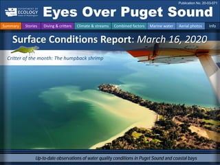
  • 1. Up-to-date observations of water quality conditions in Puget Sound and coastal bays Surface Conditions Report: March 16, 2020 Eyes Over Puget Sound Publication No. 20-03-071 Summary Stories Diving & critters Climate & streams Combined factors Marine water Aerial photos Info Critter of the month: The humpback shrimp
  • 2. The kelp Humpback shrimp p. 4 The kelp humpback shrimp is a master of camouflage. Water visibility for divers p. 5 Now would be the time to go diving, the water is clear. Climate & streams p. 6-10 After a wet January, precipitation currently is low. Most of the winter has been normal but currently its cooler. As a result rivers presently run lower than expected. Rivers in general have been flowing low since last year. Water temperature and food web p. 12 While low temperatures allow herring to spawn, we are now in March approaching the survival threshold for anchovies, around 8 °C. Aerial photography p. 13-29 First spring blooms develop in response to sunnier conditions and stain the water of finger inlets in South Sound green. Jellyfish patches are numerous only in Eld Inlet. Herring are reported to be spawning in the northern regions of Puget Sound, but not yet in South Sound. Northerly winds and waves resuspended sediment in exposed north-facing beaches of South Sound. LONG-TERM MARINE ITORING UNIT Editorial assistance provided by: Elisa Rauschl, Julianne Ruffner, Valerie Partridge. Summary conditions at a glance Summary Stories Diving & critters Climate & streams Combined factors Marine water Aerial photos Info Skip Albertson Dr. Christopher Krembs (Editor) Tyler Burks Jeff Marti Dany Burgess Angela Eagleston
  • 3. Above: I sort invertebrates into phyla Below: I filter water samples for chlorophyll-a My name is Tyler Ransier, and I am the marine monitoring intern for the year of 2020. Although I’ve only been a part of the MMU team for five months now, I have gotten the opportunity to assist with a huge variety of exceptional projects, programs and people. Here is a snapshot of some of the awesome work I’ve been helping out with so far! Above: I help collect water samples using a CTD Below: We also collect CTD data via float plane My Experience so far as the Marine Monitoring Intern with the MMU Tyler Ransier – Washington Conservation Corps Intern Personal Field Impression Summary Stories Diving & critters Climate & streams Combined factors Marine water Aerial photos Info Personal Field Impression 3-16-2020
  • 4. Critter of the month – The Kelp Humpback Shrimp Dany Burgess Marine Sediment monitoring Team Kelp Humpback Shrimp Facts • Important food source for juvenile rockfish and other predators • May be distinguished from similar species by counting the tiny points at the end of its “snout” Hippolytes clarki The kelp humpback shrimp is a master of camouflage – with its green or brown color, it blends in perfectly with its eelgrass (or kelp) home. It may be tiny, but it is a big player in the Puget Sound food web! Image by Dave Cowles, wallawalla.edu Image by Aaron Baldwin, Alaska Dept of Fish and Game Summary Stories Diving & critters Climate & streams Combined factors Marine water Aerial photos Info Eyes Under Puget Sound 3-16-2020 Learn more about the kelp humpback shrimp and other critters on Ecology’s EcoConnect blog here
  • 5. Best and poor horizontal visibility at corresponding vertical depth Good Poor Visibility (only best visibility shown) Find depths with high/low visibility • Best visibility occurred in Hood Canal near Octopus Hole (location 11), with almost 40 ft visibility at about 90 ft depth. • Poor visibility (no diver icon) occurred near the surface in Mukilteo (location 6) and in Oakland Bay near Shelton (location 14). • Explaination: “Underwater Visibility Maps — a Tool for Scuba Divers,” is available here. February: Imagine you can better see the diver underwater water at good visibility, darker contour. Location Best Visibility Worst Visibility Horizontal Distance (ft.) Vertical Depth (ft.) Horizontal Distance (ft.) Vertical Depth (ft.) 1 15 49 14 5 2 11 44 7 7 3 -2 3 15 34 4 22 38 10 5 5 16 3 16 97 6 20 46 5 3 7 18 46 7 11 8 21 95 13 8 9 22 39 11 5 10 17 10 11 48 11 37 90 13 11 12 22 69 19 20 13 22 98 10 11 14 5 5 5 23 15 12 43 8 7 16 13 7 10 44 17 12 21 8 51 What was the water visibility like for divers? Personal Field Impression Summary Stories Diving & critters Climate & streams Combined factors Marine water Aerial photos Info What can you find underwater?
  • 6. How much water did we get and what can we expect? Summary Stories Diving & critters Climate & streams Combined factors Marine water Aerial photos Info In March, Puget Sound air temperatures were below normal while precipitation was near to below normal (A). Nearing the seasonal peak of snowpack accumulation, watersheds that drain to Puget Sound hold near-normal volumes (B). Monitoring snowmelt rates and timing will be critical as we transition to spring and summer. Will trends in early snowmelt runoff peaks continue? A. Northwest Climate Toolbox B. Washington SNOTEL, USDA/NRCS Temperature Anomaly from historical mean daily ranged from +1 to -4 °F in the Puget Sound region during the past 30 days. Precipitation Anomaly from historical mean ranged from 0 to -12 inches in the Puget Sound region during the past 30 days. Snow water equivalent percent of median for watersheds draining to Puget Sound are just above normal. Nearing the typical peak of seasonal snowpack accumulation, April 1st, snow water equivalents are at 109% of the historical median. March 26th, 2020 Temperature Precipitation
  • 7. Daily average discharge, in cubic feet per second Select Puget Sound Streamflow Trends Daily average discharge, in cubic feet per second Current Streamflow Conditions as of 3/26/2020 Current conditions: CLICK HERE! USGS WaterWatch: CLICK HERE! Skagit River near Mt. Vernon (12200500) Snohomish River near roe (12150800) How much water flows into Puget Sound? Summary Stories Diving & critters Climate & streams Combined factors Marine water Aerial photos Info Cool and dry conditions during March have resulted in below normal flows in larger, snow-dominated watersheds (see trend charts). Most stream gages are reporting normal to far-below-normal flows, especially those that are in rain-dominated watersheds (see map). With a normal snowpack this year, temperature will be the main driver of a sustained freshwater supply to Puget Sound.
  • 8. How much water did we get and what can we expect? Summary Stories Diving & critters Climate & streams Combined factors Marine water Aerial photos Info Statewide snowpack measured 109 percent of normal on April 1st. This is a tremendous comeback from where it was on January 1st: 50 percent of normal. Ample snowpack at higher elevations means that mainstream rivers like the Skagit, Nooksack, Snohomish, Stillaguamish in snowpack-dominated basins are forecasted to experience normal to above normal runoff from April through September. Snowpack fed basins are in good shape, but lower elevation basins and non-snowpack fed tributaries need precipitation. Many rain-dominated, lower- elevation basins – like the Chehalis -- are forecasted to experience below-normal runoff from April to September. This includes the Samish, Deschutes, Skokomish, Dungeness, Elwha and Wynoochee Rivers.
  • 9. Climate :How wellis the Salish Sea exchanging its water? The Fraser River is the major driver of estuarine circulation and water exchange between the Salish Sea and the ocean. The Fraser River has regained expected levels. The Canadian snow basin index for the Fraser River is at 117%, predicting a strong freshet — click here Historically, the peaks of coastal upwelling and the freshet are in sync. In early 2020 Fraser R. flows are expected. NPGO (x10) PDO/Upwelling Index How do ocean boundary conditions affect the quality of water we exchange with the ocean? Recent years’ warm water is mostly gone (PDO). Upwelling (Upwelling Index anomaly) is relative expected. NPGO, which reflects the surface productivity along the coast, has not been updated since July 2019. Pacific Decadal Oscillation Index (PDO, temperature, explanation). Upwelling Index (anomalies) (Upwelling, low oxygen, explanation). North Pacific Gyre Oscillation Index (NPGO, productivity, explanation). Three-year running average of PDO, Upwelling, and NPGO Indices Summary Stories Diving & critters Climate & streams Combined factors Marine water Aerial photos Info Fraser River (at midnight) Higher than normal Lower than normal Expected
  • 10. Climate: How wellis Puget Sound exchanging its water? The Skagit River freshet is no longer clearly pronounced, because it is a regulated system. However, drought years and low flows can be seen in the river’s discharge data. Freshwater is an important component determining the stratification of surface water in Puget Sound. Drought years weaken the extent of stratification. The Skagit River is the largest freshwater source for Puget Sound. It is a river that is regulated. Summary Stries Diving & critters Climate & streams Combined factors Marine water Aerial photos Info River flows and upwelling in the summer influence our water quality. Rivers strengthen estuarine circulation in the Salish Sea. This is important in the summer. Upwelled ocean water provides cool, nutrient-rich water. For that to happen, we need northerly winds and good river flows (a good snowpack) during periods of water exchange through Admiralty Reach (neap tides). Normal river flows drive “natural” nutrient inputs and keep the water cool. Low river flows change the nutrient balance and makes water warmer. Skagit River (at midnight) Higher than normal Lower than normal Expected
  • 11. higher No data lower expected *Upwelling/downwelling Anomalies (PFEL) PDO = Pacific Decadal Oscillation ENSO = El Niño Southern Oscillation All data are from public sources: UW GRAYSKIES; river flows from USGS and Environment Canada; indices from NOAA & UW (PDO). 2017 2018 What influences Puget Sound’s water quality? Summary Stories Diving & critters Climate & streams Combined factors Marine water Aerial photos Info In the anomaly plot, we want to connect different factors influencing water quality in the context of space and time. Air temperatures in the past year have generally been warmer, and the overall amount of rain has been low (note anomalies relative to a baseline in summer over-emphasize a weak summer rain). 2020 fortunately started out with high precipitation, and rivers are responding. For recent river and stream inflow, see pages 6-7. Conditions leading up to March: Air temperatures have been warmer this winter, with a cold period only in October. Precipitation for fall was low, but January was the 4th-wettest on record. Sunshine (opposite of cloud cover) has been cycling between higher and lower values. River flows have mostly been low since last year, June 2018, but now regained strength in some places. Upwelling started to be less predictable, as in the previous year.
  • 12. Summary Stories Diving & critters Climate & streams Combined factors Marine water Aerial photos Info Water temperature affects ecosystem performance Warmer than expected Cooler than expected Expected 18-year average Legend: Can organisms thrive and survive? The life cycles of organisms respond to temperature. To be successful, the timing of early life stages must line up with good growth conditions. Temperature is important for growth, but also dictates if certain organisms can overwinter in Puget Sound (e.g., northern anchovy). * Help us get these right. We scoured the literature for temperatures important to the success and survival of marine organisms. Lifecycles Temperature Climate In February, average surface water (0 – 30 m) temperatures were still slightly above the baseline (1999 – 2018) across many regions. Water temperatures were in ranges for spawning for herring, but gradually approaching the minimum survival temperature for anchovies of about 8.2 °C. Coldest water temperatures currently occur in Puget Sound right now, in March (data not available yet). Temperatures do not reflect nearshore conditions that can be quite different. Optimal temperatures for Puget Sound organisms*
  • 13. What are the conditions at the surface? Start here Bloom Debris Front Plume Narrow Hammersley Inlet connecting Oakland Bay Mixing and fronts: Tidal eddy off McNeil Island nicely visible through resuspended nearshore sediment. Debris: Low levels restricted in South Sound to only Dana Passage. Visible blooms: First signs of a spring bloom developing in all Finger Inlets of South Sound. Jellyfish: Numerous only in Eld Inlet but present in Totten and Budd Inlets in few and small patches. Suspended sediment: Sediment suspended by waves on many beaches facing north. Both ship traffic and shellfish-harvesting create local sediment disturbances. Summary Stories Diving & critters Climate & streams Combined factors Marine water Aerial photos Info Large ships come all the way into South Sound. The de Havilland Beaver float plane, a great workhorse. Watch video First spring blooms develop in response to sunnier conditions and stain the water of finger inlets in South Sound green. Jellyfish patches are numerous only in Eld Inlet. Herring are reported to be spawning in the northern regions of Puget Sound (click here), but not yet in South Sound. Northerly winds and waves re-suspended sediment in exposed north-facing beaches of South Sound.
  • 14. Flight Strait of Juan de Fuca San Juan Islands Main Basin Hood Canal Whidbey Basin Sunny and hazy, moderate wind south of Tacoma Narrows, >20 knots winds out of the North past the Tacoma Narrows. Note: Flight route was changed due to strong winds north of the Tacoma Narrows. Flight Observations Aerial navigation guide South Sound Summary Stories Diving & critters Climate & streams Combined factors Marine water Aerial photos Info Padilla Bay Tide data from 3/16/2020 (Seattle): Time Pred (ft) High/Low 05:11 AM 7.02 L 10:28 AM 10.26 H 05:37 PM 0.24 L 7 8 5 15 14 2 6 10 11 12 13 1 3 4 9 Strong wind
  • 15. No wind at the Port of Olympia. Little did we know that winds would pick up past the Tacoma Narrows. Location: Port of Olympia, Budd Inlet (South Sound), 11:26 AM 1 Aerial photography 3-16-2020 Navigate Summary Stories Diving & critters Climate & streams Combined factors Marine water Aerial photos Info West Bay
  • 16. Large ship approaching the Port of Olympia and stirring up sediment. Location: Budd Inlet (South Sound), 11:27 AM 2 Navigate Summary Stories Diving & critters Climate & streams Combined factors Marine water Aerial photos Info Aerial photography 3-16-2020 ship sediment Priest Point Park
  • 17. Water flowing past Boston Harbor reveals a spring bloom in Budd Inlet. Location: Dana Passage (South Sound), 11:20 AM 3 Navigate Summary Stories Diving & critters Climate & streams Combined factors Marine water Aerial photos Info Aerial photography 3-16-2020 Bloom Dofflemyer Point Dover Point Brisco Point boat
  • 18. South Sound has beautiful islands and waterways. Location: Squaxin Island (South Sound), 11:22 AM 4 Navigate Summary Stories Diving & critters Climate & streams Combined factors Marine water Aerial photos Info Aerial photography 3-16-2020
  • 19. Patches of jellyfish are present in Eld Inlet, but otherwise almost absent in other South Sound Inlets. Location: Eld Inlet (South Sound), 11:32 AM 5 Navigate Summary Stories Diving & critters Climate & streams Combined factors Marine water Aerial photos Info Aerial photography 3-16-2020 jellyfish jellyfish jellyfish Sunrise Beach
  • 20. Surface water in finger inlets of South Sound are stratified. A boat mixing the surface layer in Oyster Bay. Location: Totten Inlet (South Sound), 11:35 AM 6 Navigate Summary Stories Diving & critters Climate & streams Combined factors Marine water Aerial photos Info Aerial photography 3-16-2020 Hurley Cove boat pens plane shadow
  • 21. 7 Navigate Summary Stories Diving & critters Climate & streams Combined factors Marine water Aerial photos Info Aerial photography 3-16-2020 All finger inlets of South Sound have river inputs; like the Skookum Creek, most currently carry little sediment. Location: Little Skookum Inlet (South Sound), 11:37 AM Skookum River
  • 22. Sediment resuspension by underwater shellfish extraction (see boat) and at wave-exposed beaches. Location: McMciken Island, Case Inlet (South Sound), 11:47 AM 8 Navigate Summary Stories Diving & critters Climate & streams Combined factors Marine water Aerial photos Info Aerial photography 3-16-2020 Herron Island boat sediment sediment McMicken Island
  • 23. Sediment resuspension on wave-exposed beaches. Location: Harstine Island, Case Inlet (South Sound), 11:48 AM 9 Navigate Summary Stories Diving & critters Climate & streams Combined factors Marine water Aerial photos Info Aerial photography 3-16-2020 Herron Island sediment sediment boat
  • 24. Clear freshwater of the Skokomish entering Hood Canal at Union. Location: Union (Hood Canal), 12:02 PM 10 Navigate Summary Stories Diving & critters Climate & streams Combined factors Marine water Aerial photos Info Aerial photography 3-16-2020 SkokomishRiver
  • 25. Strong winds meet tidal current passing the Tacoma Narrows in opposite direction, causing high waves. Location: Point Defiance (Central Sound), 12:20 PM 11 Navigate Summary Stories Diving & critters Climate & streams Combined factors Marine water Aerial photos Info Aerial photography 3-16-2020 Vashon Island Point Defiance
  • 26. Strong northerly winds cause sediment resuspension on wave-exposed north-facing beaches. Location: Carr Inlet (South Sound), 12:25 PM 12 Navigate Summary Stories Diving & critters Climate & streams Combined factors Marine water Aerial photos Info Aerial photography 3-16-2020 South Head sediment
  • 27. Resuspended sediment can travel along shore to be redeposited elsewhere. Location: Carr Inlet (South Sound), 12:26 PM 13 Navigate Summary Stories Diving & critters Climate & streams Combined factors Marine water Aerial photos Info Aerial photography 3-16-2020 sediment sediment
  • 28. Resuspended sediment makes nearshore tidal eddies visible. A. looking north, B. looking south. Location: Pitt Passage, McNeil Island Carr Inlet (South Sound), 12:28 PM A. B. 14 Navigate Summary Stories Diving & critters Climate & streams Combined factors Marine water Aerial photos Info Aerial photography 3-16-2020 sediment sediment eddy eddy plane shadow
  • 29. Spring bloom in Henderson Inlet has started. A. Looking West, B. Flowing into Dana Passage. C. Looking south. Location: Henderson Inlet (South Sound) 12:32 PM A. B. C. 15 Navigate Summary Stories Diving & critters Climate & streams Combined factors Marine water Aerial photos Info Aerial photography 3-16-2020 Harstine Island Bloom Bloom Bloom Woodard Bay Johnson Point Johnson Point
  • 30. Contact: Dr. Christopher Krembs Christopher.Krembs@ecy.wa.gov Marine itoring Unit Environmental Assessment Program Washington State Department of Ecology Subscribe to the Eyes Over Puget Sound email listserv. Many thanks to our business partners: Shannon Point Marine Lab (WWU), Swantown Marina, and Kenmore Air. Find past editions of EOPS on the next pages Summary Stories Diving & critters Climate & streams Combined factors Marine water Aerial photos Info We have published 86 editions! Recommended Citation (example for September 2018 edition): Washington State Department of Ecology. 2018. Eyes Over Puget Sound: Surface Conditions Report, September 17, 2018. Publication No. 18-03-075. Olympia, WA. https://fortress.wa.gov/ecy/publications/documents/1803075.pdf. Find all previous Eyes Over Puget Sound editions at the end of this document.
  • 31. Month_date_year, Publication No. 20-03-07X Month_date_year, Publication No. 20-03-07X Month_date_year, Publication No. 20-03-07X Month_date_year, Publication No. 20-03-07X March_16_2020, Publication No. 20-03-071 Jan_10_2020, Publication No. 20-03-070 October_30_2019, Publication No. 19-03-076 September_12_2019, Publication No. 19-03-075 July_29_2019 Publication No. 19-03-074 June_4_2019, Publication No. 19-03-073 March_26_2019, Publication No. 19-03-072 February_21_2019, Publication No. 19-03-071 January_10_2019, Publication No. 19-03-070 November_6_2018, Publication No. 18-03-075 September_17_2018, Publication No. 18-03-074 July_16_2018, Publication No. 18-03-073 June_28_2018, Publication No. 18-03-072 May_22_2018, Publication No. 18-03-025 April_19_2018, Publication No. 18-03-071 Winter_2018, Publication No. 18-03-070
  • 32. October_31_2017, Publication No. 17-03-073 August_28_2017, Publication No. 17-03-072 July_24_2017, Publication No. 17-03-071 June_6_2017, Publication No. 17-03-070 December_31_2016, Publication No. 16-03-079 November_22_2016, Publication No. 16-03-078 September_26_2016, Publication No. 16-03-077 August_24_2016, Publication No. 16-03-076 July_20_2016, Publication No. 16-03-075 June_27_2016, Publication No. 16-03-074 May_2_2016, Publication No. 16-03-073 April_6_2016, Publication No. 16-03-072 March_16_2016, Publication No. 16-03-071 February_8_2016, Publication No. 16-03-070 December_30_2015, Publication No. 15-03-080 December_14_2015, Publication No. 15-03-079 October_6_2015, Publication No. 15-03-078 September_21_2015, Publication No. 15-03-077 August_8_2015, Publication No. 15-03-076 July_6_2015, Publication No. 15-03-075
  • 33. June_8_2015, Publication No. 15-03-074 April_29_2015, Publication No. 15-03-073 March_24_2015, Publication No. 15-03-072 February_17_2015, Publication No. 15-03-071 January_28_2015, Publication No. 15-03-070 December_30_2014, Publication No. 14-03-080 November_17_2014, Publication No. 14-03-079 October_29_2014, Publication No. 14-03-078 September_16_2014, Publication No. 14-03-077 August_18_2014, Publication No. 14-03-076 July_28_2014, Publication No. 14-03-075 June_23_2014, Publication No. 14-03-074 May_12_2014, Publication No. 14-03-073 April_21_2014, Publication No. 14-03-072 March_24_2014, Publication No. 14-03-071 February_4_2014, Publication No. 14-03-070 December_31_2013, Publication No. 13-03-081 November_21_2013, Publication No. 13-03-080 October_28_2013, Publication No. 13-03-079 September_11_2013, Publication No. 13-03-078
  • 34. August_21_2013, Publication No. 13-03-077 July_15_2013, Publication No. 13-03-076 June_17_2013, Publication No. 13-03-075 May_20_2013, Publication No. 13-03-074 April_8_2013, Publication No. 13-03-073 Mar_25_2013, Publication No. 13-03-072 February_26_2013, Publication No. 13-03-071 January_15_2013, Publication No. 13-03-070 December_13_2012, Publication No. 12-03-081 November_8_2012, Publication No. 12-03-080 October_8_2012, Publication No. 12-03-079 September_11_2012, Publication No. 12-03-078 August_27_2012, Publication No. 12-03-077 July_31_2012, Publication No. 12-03-076 June_12_2012, Publication No. 12-03-075 May_14_2012, Publication No. 12-03-074 April_23_2012, Publication No. 12-03-073 March_19_2012, Publication No. 12-03-072 February_27_2012, Publication No. 12-03-071 January_30_2012, Publication No. 12-03-070
  • 35. December_5_2011, Publication No. 11-03-082 November_15_2011, Publication No. 11-03-081 October_17_2011, Publication No. 11-03-080 September_12_2011, Publication No. 11-03-079 August_8_2011, Publication No. 11-03-078 July_6_2011, Publication No. 11-03-077 June_20_2011, Publication No. 11-03-076 June_6_2011, Publication No. 11-03-075 May_4_2011, Publication No. 11-03-074 April_27_2011, Publication No. 11-03-073