North Park Offices - Old Sastech building.ppt
•Als PPT, PDF herunterladen•
0 gefällt mir•2 views
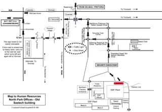
This document contains a map with directions between locations in and around Evander, South Africa. It provides 12 directions between mines, towns, and roads, noting street names, alternate routes if roads are closed, and landmarks like reservoirs. It also labels the route from Delmas and Pretoria on the N17 and R77 highways from Johannesburg.
Melden
Teilen
Melden
Teilen
Empfohlen
Empfohlen
+971581248768>> SAFE AND ORIGINAL ABORTION PILLS FOR SALE IN DUBAI AND ABUDHABI}}+971581248768in dubai+971581248768_)whatsapp*abortion pills in dubai/buy cytotec misoprostol and mifepristone in dubai
More arrow_drop_down
WHATSAPP +971581248768 ABORTION PILLS IN DUBAI,MISOPROSTOL IN DUBAI,@CYTOTEC TABLETS IN DUBAI/cytotec in abu dhabi/abortion pills in sharjah/MIFEPRISTONE IN DUBAI/misoprostol in ajman/@abortion pills in ras al khaimah@mifepristone in sharjah>mifepristone in abu dhabi>ABORTION PILLS FOR SALE IN ABU DHABI,KUWAIT,AJMAN,SHARJAH,RAS AL KHAIMAHSALMIYA,AL WAKRAH,JOHANNESBURG,AL AIN,CYTOTEC IN DUBAI+971581248768 cytotec price in dubai,abu dhabi.al ain,ajman,sharjah,,OTTAWA,ALBERTA,CALGARY,TORONTO,IDAHO,OHIO, Midrand ,Sandton,Hyde Park,Johannesburg,New Hampshire,South Dakota,North Dakota,how how can i get abortion pills in dubai ,abu dhabi,,riyadh.oman.muscat,Arkansas ,Kansas,West Virginia, abortion pills in for sale in dubai.abu dhabi+971581248768 Oklahoma,Nebraska,Vermont,Idaho,South Carolina,Wisconsin ~ misoprostol price in dubai.ajman.al ain.kuwaitcity,Alabama,Maine,New Mexico, soweto+971581248768,cytotec pills in kuwait,sharjah,ajman,ras al khaimahMissouri,, un wanted kit in dubai, Victoria, Sydney, ajman, Botswana ,misoprostol in abu dhabi.sharjah.dubai Alabama,get abortion pills in ras al khaimah,al ain,ajman,abu dhabi.sharjah,kuwaitcity,al satwa,deira. Charlotte,Austin,San Francisco,New York,Seattle,farwaniyah,cytotec pills for sale in al ain ,ajman,dubai,Washington,misoprostol tablets available +971581248768 in dubai,abu dhabi,sharjah,al ain,deira,ajman) abortion pills in abu dhabi,sharjah,dubai,fujairah,jumeirah,ras al khaimah,Rockhampton,Toowoomba,Coffs Harbour,J!~+971581248768>> SAFE AND ORIGINAL ABORTION PILLS FOR SALE IN DUBAI AND ABUD...
!~+971581248768>> SAFE AND ORIGINAL ABORTION PILLS FOR SALE IN DUBAI AND ABUD...DUBAI (+971)581248768 BUY ABORTION PILLS IN ABU dhabi...Qatar
Saudi Arabia [ Abortion pills) Jeddah/riaydh/dammam/++918133066128☎️] cytotec tablets uses abortion pills 💊💊 How effective is the abortion pill? 💊💊 +918133066128) "Abortion pills in Jeddah" how to get cytotec tablets in Riyadh " Abortion pills in dammam*💊💊 The abortion pill is very effective. If you’re taking mifepristone and misoprostol, it depends on how far along the pregnancy is, and how many doses of medicine you take:💊💊 +918133066128) how to buy cytotec pills
At 8 weeks pregnant or less, it works about 94-98% of the time. +918133066128[ 💊💊💊 At 8-9 weeks pregnant, it works about 94-96% of the time. +918133066128) At 9-10 weeks pregnant, it works about 91-93% of the time. +918133066128)💊💊 If you take an extra dose of misoprostol, it works about 99% of the time. At 10-11 weeks pregnant, it works about 87% of the time. +918133066128) If you take an extra dose of misoprostol, it works about 98% of the time. In general, taking both mifepristone and+918133066128 misoprostol works a bit better than taking misoprostol only. +918133066128 Taking misoprostol alone works to end the+918133066128 pregnancy about 85-95% of the time — depending on how far along the+918133066128 pregnancy is and how you take the medicine. +918133066128 The abortion pill usually works, but if it doesn’t, you can take more medicine or have an in-clinic abortion. +918133066128 When can I take the abortion pill?+918133066128 In general, you can have a medication abortion up to 77 days (11 weeks)+918133066128 after the first day of your last period. If it’s been 78 days or more since the first day of your last+918133066128 period, you can have an in-clinic abortion to end your pregnancy.+918133066128
Why do people choose the abortion pill? Which kind of abortion you choose all depends on your personal+918133066128 preference and situation. With+918133066128 medication+918133066128 abortion, some people like that you don’t need to have a procedure in a doctor’s office. You can have your medication abortion on your own+918133066128 schedule, at home or in another comfortable place that you choose.+918133066128 You get to decide who you want to be with during your abortion, or you can go it alone. Because+918133066128 medication abortion is similar to a miscarriage, many people feel like it’s more “natural” and less invasive. And some+918133066128 people may not have an in-clinic abortion provider close by, so abortion pills are more available to+918133066128 them. +918133066128 Your doctor, nurse, or health center staff can help you decide which kind of abortion is best for you. +918133066128 More questions from patients: Saudi Arabia+918133066128 CYTOTEC Misoprostol Tablets. Misoprostol is a medication that can prevent stomach ulcers if you also take NSAID medications. It reduces the amount of acid in your stomach, which protects your stomach lining. The brand name of this medication is Cytotec®.+918133066128) Unwanted Kit is a combination of two medicines, ounwanted pregnancy Kit [+918133066128] Abortion Pills IN Dubai UAE Abudhabi
unwanted pregnancy Kit [+918133066128] Abortion Pills IN Dubai UAE AbudhabiAbortion pills in Kuwait Cytotec pills in Kuwait
Weitere ähnliche Inhalte
Kürzlich hochgeladen
+971581248768>> SAFE AND ORIGINAL ABORTION PILLS FOR SALE IN DUBAI AND ABUDHABI}}+971581248768in dubai+971581248768_)whatsapp*abortion pills in dubai/buy cytotec misoprostol and mifepristone in dubai
More arrow_drop_down
WHATSAPP +971581248768 ABORTION PILLS IN DUBAI,MISOPROSTOL IN DUBAI,@CYTOTEC TABLETS IN DUBAI/cytotec in abu dhabi/abortion pills in sharjah/MIFEPRISTONE IN DUBAI/misoprostol in ajman/@abortion pills in ras al khaimah@mifepristone in sharjah>mifepristone in abu dhabi>ABORTION PILLS FOR SALE IN ABU DHABI,KUWAIT,AJMAN,SHARJAH,RAS AL KHAIMAHSALMIYA,AL WAKRAH,JOHANNESBURG,AL AIN,CYTOTEC IN DUBAI+971581248768 cytotec price in dubai,abu dhabi.al ain,ajman,sharjah,,OTTAWA,ALBERTA,CALGARY,TORONTO,IDAHO,OHIO, Midrand ,Sandton,Hyde Park,Johannesburg,New Hampshire,South Dakota,North Dakota,how how can i get abortion pills in dubai ,abu dhabi,,riyadh.oman.muscat,Arkansas ,Kansas,West Virginia, abortion pills in for sale in dubai.abu dhabi+971581248768 Oklahoma,Nebraska,Vermont,Idaho,South Carolina,Wisconsin ~ misoprostol price in dubai.ajman.al ain.kuwaitcity,Alabama,Maine,New Mexico, soweto+971581248768,cytotec pills in kuwait,sharjah,ajman,ras al khaimahMissouri,, un wanted kit in dubai, Victoria, Sydney, ajman, Botswana ,misoprostol in abu dhabi.sharjah.dubai Alabama,get abortion pills in ras al khaimah,al ain,ajman,abu dhabi.sharjah,kuwaitcity,al satwa,deira. Charlotte,Austin,San Francisco,New York,Seattle,farwaniyah,cytotec pills for sale in al ain ,ajman,dubai,Washington,misoprostol tablets available +971581248768 in dubai,abu dhabi,sharjah,al ain,deira,ajman) abortion pills in abu dhabi,sharjah,dubai,fujairah,jumeirah,ras al khaimah,Rockhampton,Toowoomba,Coffs Harbour,J!~+971581248768>> SAFE AND ORIGINAL ABORTION PILLS FOR SALE IN DUBAI AND ABUD...
!~+971581248768>> SAFE AND ORIGINAL ABORTION PILLS FOR SALE IN DUBAI AND ABUD...DUBAI (+971)581248768 BUY ABORTION PILLS IN ABU dhabi...Qatar
Saudi Arabia [ Abortion pills) Jeddah/riaydh/dammam/++918133066128☎️] cytotec tablets uses abortion pills 💊💊 How effective is the abortion pill? 💊💊 +918133066128) "Abortion pills in Jeddah" how to get cytotec tablets in Riyadh " Abortion pills in dammam*💊💊 The abortion pill is very effective. If you’re taking mifepristone and misoprostol, it depends on how far along the pregnancy is, and how many doses of medicine you take:💊💊 +918133066128) how to buy cytotec pills
At 8 weeks pregnant or less, it works about 94-98% of the time. +918133066128[ 💊💊💊 At 8-9 weeks pregnant, it works about 94-96% of the time. +918133066128) At 9-10 weeks pregnant, it works about 91-93% of the time. +918133066128)💊💊 If you take an extra dose of misoprostol, it works about 99% of the time. At 10-11 weeks pregnant, it works about 87% of the time. +918133066128) If you take an extra dose of misoprostol, it works about 98% of the time. In general, taking both mifepristone and+918133066128 misoprostol works a bit better than taking misoprostol only. +918133066128 Taking misoprostol alone works to end the+918133066128 pregnancy about 85-95% of the time — depending on how far along the+918133066128 pregnancy is and how you take the medicine. +918133066128 The abortion pill usually works, but if it doesn’t, you can take more medicine or have an in-clinic abortion. +918133066128 When can I take the abortion pill?+918133066128 In general, you can have a medication abortion up to 77 days (11 weeks)+918133066128 after the first day of your last period. If it’s been 78 days or more since the first day of your last+918133066128 period, you can have an in-clinic abortion to end your pregnancy.+918133066128
Why do people choose the abortion pill? Which kind of abortion you choose all depends on your personal+918133066128 preference and situation. With+918133066128 medication+918133066128 abortion, some people like that you don’t need to have a procedure in a doctor’s office. You can have your medication abortion on your own+918133066128 schedule, at home or in another comfortable place that you choose.+918133066128 You get to decide who you want to be with during your abortion, or you can go it alone. Because+918133066128 medication abortion is similar to a miscarriage, many people feel like it’s more “natural” and less invasive. And some+918133066128 people may not have an in-clinic abortion provider close by, so abortion pills are more available to+918133066128 them. +918133066128 Your doctor, nurse, or health center staff can help you decide which kind of abortion is best for you. +918133066128 More questions from patients: Saudi Arabia+918133066128 CYTOTEC Misoprostol Tablets. Misoprostol is a medication that can prevent stomach ulcers if you also take NSAID medications. It reduces the amount of acid in your stomach, which protects your stomach lining. The brand name of this medication is Cytotec®.+918133066128) Unwanted Kit is a combination of two medicines, ounwanted pregnancy Kit [+918133066128] Abortion Pills IN Dubai UAE Abudhabi
unwanted pregnancy Kit [+918133066128] Abortion Pills IN Dubai UAE AbudhabiAbortion pills in Kuwait Cytotec pills in Kuwait
Kürzlich hochgeladen (20)
Al Mizhar Dubai Escorts +971561403006 Escorts Service In Al Mizhar
Al Mizhar Dubai Escorts +971561403006 Escorts Service In Al Mizhar
Pre Engineered Building Manufacturers Hyderabad.pptx
Pre Engineered Building Manufacturers Hyderabad.pptx
Rice Manufacturers in India | Shree Krishna Exports
Rice Manufacturers in India | Shree Krishna Exports
Uneak White's Personal Brand Exploration Presentation
Uneak White's Personal Brand Exploration Presentation
Over the Top (OTT) Market Size & Growth Outlook 2024-2030
Over the Top (OTT) Market Size & Growth Outlook 2024-2030
joint cost.pptx COST ACCOUNTING Sixteenth Edition ...
joint cost.pptx COST ACCOUNTING Sixteenth Edition ...
Lucknow Housewife Escorts by Sexy Bhabhi Service 8250092165
Lucknow Housewife Escorts by Sexy Bhabhi Service 8250092165
Getting Real with AI - Columbus DAW - May 2024 - Nick Woo from AlignAI
Getting Real with AI - Columbus DAW - May 2024 - Nick Woo from AlignAI
Marel Q1 2024 Investor Presentation from May 8, 2024
Marel Q1 2024 Investor Presentation from May 8, 2024
Jual Obat Aborsi ( Asli No.1 ) 085657271886 Obat Penggugur Kandungan Cytotec
Jual Obat Aborsi ( Asli No.1 ) 085657271886 Obat Penggugur Kandungan Cytotec
Falcon Invoice Discounting: Unlock Your Business Potential
Falcon Invoice Discounting: Unlock Your Business Potential
!~+971581248768>> SAFE AND ORIGINAL ABORTION PILLS FOR SALE IN DUBAI AND ABUD...
!~+971581248768>> SAFE AND ORIGINAL ABORTION PILLS FOR SALE IN DUBAI AND ABUD...
unwanted pregnancy Kit [+918133066128] Abortion Pills IN Dubai UAE Abudhabi
unwanted pregnancy Kit [+918133066128] Abortion Pills IN Dubai UAE Abudhabi
TVB_The Vietnam Believer Newsletter_May 6th, 2024_ENVol. 006.pdf
TVB_The Vietnam Believer Newsletter_May 6th, 2024_ENVol. 006.pdf
Falcon's Invoice Discounting: Your Path to Prosperity
Falcon's Invoice Discounting: Your Path to Prosperity
Empfohlen
More than Just Lines on a Map: Best Practices for U.S Bike Routes
This session highlights best practices and lessons learned for U.S. Bike Route System designation, as well as how and why these routes should be integrated into bicycle planning at the local and regional level.
Presenters:
Presenter: Kevin Luecke Toole Design Group
Co-Presenter: Virginia Sullivan Adventure Cycling AssociationMore than Just Lines on a Map: Best Practices for U.S Bike Routes
More than Just Lines on a Map: Best Practices for U.S Bike RoutesProject for Public Spaces & National Center for Biking and Walking
Empfohlen (20)
How to Prepare For a Successful Job Search for 2024
How to Prepare For a Successful Job Search for 2024
Social Media Marketing Trends 2024 // The Global Indie Insights
Social Media Marketing Trends 2024 // The Global Indie Insights
Trends In Paid Search: Navigating The Digital Landscape In 2024
Trends In Paid Search: Navigating The Digital Landscape In 2024
5 Public speaking tips from TED - Visualized summary
5 Public speaking tips from TED - Visualized summary
Google's Just Not That Into You: Understanding Core Updates & Search Intent
Google's Just Not That Into You: Understanding Core Updates & Search Intent
The six step guide to practical project management
The six step guide to practical project management
Beginners Guide to TikTok for Search - Rachel Pearson - We are Tilt __ Bright...
Beginners Guide to TikTok for Search - Rachel Pearson - We are Tilt __ Bright...
Unlocking the Power of ChatGPT and AI in Testing - A Real-World Look, present...
Unlocking the Power of ChatGPT and AI in Testing - A Real-World Look, present...
More than Just Lines on a Map: Best Practices for U.S Bike Routes
More than Just Lines on a Map: Best Practices for U.S Bike Routes
Ride the Storm: Navigating Through Unstable Periods / Katerina Rudko (Belka G...
Ride the Storm: Navigating Through Unstable Periods / Katerina Rudko (Belka G...
Good Stuff Happens in 1:1 Meetings: Why you need them and how to do them well
Good Stuff Happens in 1:1 Meetings: Why you need them and how to do them well
North Park Offices - Old Sastech building.ppt
- 1. Brendon village Evander Gold Mines No’s 1-10 Shafts Leandra To Standerton 12 km Evander Kinross To Trichardt = Traffic Light = Stop Street Marthinus Pretorius Str/ Helen Joseph Drive Ettienne Rossouw Str/ Oliver Thambo Drive President Swart Str/ Nelson Mandela Drive SECURITY CHECK POINT Sasol Technology Visitors’ Parking Secunda Town Centre SSF Plant Map to Human Resources North Park Offices - Old Sastech building Paul Kruger Str/ Walter Sisulu Drive Frans du Toit Str/ PDP Kruger Railway Line Alternate Route Reservoirs This sign board is not easily noticeable. If this road is closed due to heavy rains, carry on to the next tar road which turns left and again left to ‘Kinross’ Alternate: To Kinross SSF Plant Oban Kromdraai Stream Sasol Townhouse Northern Factory Entrance SSF offices Parking Public Relations Sasol Club To Secunda R50 R546 R29 To Standerton C:mydocsAToSasolClub.ppt/ek/29.09.1998 To Trichardt FROM DELMAS / PRETORIA N17 / R77 from JOHANNESBURG Block F Visitors’ Parking Block G North Park