Empfohlen

Empfohlen
Weitere ähnliche Inhalte
Empfohlen
Empfohlen (20)
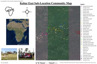
AfricaMapHandDugWell
- 1. #* #* #*^_ !( !( !( !(!( !( #* !( !( !( !( !( XY #*#* #* !( ") !( !( !( !( !( !( !( #*!( !( !( !( !(!( #* !(!( !( !( !( ") #* #* #* #*^_ ! ! ## # #* ®v !(!(!( !(!( !( !( !( !(!(!( !( !( !(!( !( !( ") ") #* !? nn"u"u !( !( !( !( !( !( !( !(!( !( !( !( #* #* #*") !( !( !( !( !( !( #* #* #* !( !( !( !( !( !( Source: Esri, DigitalGlobe, GeoEye, Earthstar Geographics, CNES/Airbus DS, USDA, USGS, AEX, Getmapping, Aerogrid, IGN, IGP, swisstopo, and the GIS User Community ² 0 0.85 1.7 2.55 3.40.425 Kilometers Legend !( Omuga B Hand Dug Well #* Omuga A Church !( Omuga A Hand Dug Well ") Kodindo School #* Kodindo Church !( Kodindo Hand Dug Well "u Masaogo Sub-District Hospital n Chief's Office !? Adegra Hand Dug Well #* Amilo A Church ") Amilo A School !( Amilo A Hand Dug Well ®v Miranga Dispensary #* Gem Kabar Church # Miranga Church ! Miranga Hand Dug Well ^_ Omanyi Market #* Omanyi Church ") Omanyi School !( Omanyi Hand Dug Well #* Nyakoko ACK Church !( Nyakoko Hand Dug Well #* Minyange B Church !( Minyange B Hand Dug Well !( Gem Kabar Hand Dug Well ") Minyange A Primary School & Well !( Nyando River #* Adegra Church #* Olasi Church XY Olasi ECD !( Olasi Hand Dug Well #* Kanyinyang' Church !( Kanyinyang' Hand Dug Well ^_ Omuga B Market Center #* Omuga B Church #*#*#*^_!(!(!(!(!(!(#*#*!(!(!(!(!(XY#*#*#*#*!(XY!(!(!(!(!(!(!(#*!(!(!(!(!(!(#*!(!(!(!(!(")#*#*#*#*^_!!####*"u!(!(!(!(!(!(!(!(!(!(!(!(!(!(!(!(!(")")#*!(aa"u"u!(!(!(!(!(!(!(!(!(!(!(!(#*#*#*#*")!(!(!( !( !(!(!(#*#*#*!(!(!(!(!(!( Source: Esri, DigitalGlobe, GeoEye, Earthstar Geographics, CNES/Airbus DS, USDA, USGS, AEX, Getmapping, Aerogrid, IGN, IGP, swisstopo, and the GIS User Community Kabar East Sub-Location Community Map By: Cody Wilhelm In accreditation to Alice Visionary Foundation Project 2015 This Map is symbolizing Schools, Water-Points, Churches, and Markets for Kabar East Sub-Location, Kenya.