Dale City, VA Retrofit Strategy
•Als PPT, PDF herunterladen•
1 gefällt mir•647 views

An AIA Sustainable Design Assessment Team produced a suburban retrofit strategy for the Dale Blvd corridor in Dale City, VA, following a 3-day community process.

Empfohlen
Empfohlen
Weitere ähnliche Inhalte
Was ist angesagt?
Was ist angesagt? (14)
Ähnlich wie Dale City, VA Retrofit Strategy
Ähnlich wie Dale City, VA Retrofit Strategy (20)
Mehr von American Institute of Architects
Mehr von American Institute of Architects (20)
Kürzlich hochgeladen
Kürzlich hochgeladen (20)
Dale City, VA Retrofit Strategy
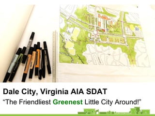
- 1. Dale City, Virginia AIA SDAT “The Friendliest Greenest Little City Around!”
- 2. Presentation Outline 1. Process: Reframing the Challenges 2. Changing the Economic Model 3. Street Character / Connectivity / Mobility 4. A Vision for Walkable Downtown Dale City 5. Implementation Strategies
- 4. The Challenge: Re-energize Dale Blvd “West Gateway” (@ Hoadley) “Mapledale” (@ Ridgefield)
- 5. “Minnieville” (@ Dale Blvd) “East Gateway” (@ Gideon) The Challenge: Re-energize Dale Blvd
- 6. AIA SDAT Process • We came – 3 days with 6 professionals from across the country – June (NY), Ed (OR), Cheryl (AL), Pat (CA), David (WA) and Ken (MA) • We saw – Toured Dale Boulevard • We listened – 1 day of stakeholder meetings & town hall meeting • We planned – 2 days of intensive brainstorming, research, diagramming & sketching
- 7. We saw… touring Dale City Kmart “ghostbox” Center Plaza Bus shelter Neabsco Greenway
- 8. We saw… touring Dale City
- 9. We listened… stakeholder sessions
- 10. What we heard • Placemaking / Community – Lack of “destination” places and places for neighbors to gather – Desire for walkability – Shopping centers are tired and unappealing • Transportation / Streetscape – Road “improvements” make traffic worse – Lack of bike infrastructure – Loss of median trees • Land Use / Economic Development – Deteriorated sites, buildings and services – New commercial development bypassed Dale City – Outdated approvals process
- 11. We listened… town hall meeting
- 12. What we heard • GOOD STUFF – Greenery and open space – Diversity of residents – Good neighborhoods – Affordability of housing – Access to services – Easy to get out of town • NEEDS TO CHANGE – Placelessness – Traffic congestion – Lack of sidewalks and bike paths – Rundown properties – Jobs/housing imbalance
- 13. We planned… for a better Dale City • First steps: redefine the challenge of suburban corridor retrofit: • Why these four nodes? • Too many? Too few? How big? • Dale City needs a center: where? • What would/could “revitalization” look like? • Which tools to use to make it happen?
- 14. Dale City: Vision Framework • New tagline: “The Friendliest Greenest Little City Around” • What do we mean by Greenest? – Physical: trails, trees and parks – Cultural: authentically diverse suburbia – Ecology: walking and cycling, not only car – Wellness: community supports a healthy lifestyle for families and aging residents
- 15. “West Gateway” (@ Hoadley Road) • Not an significant node for community gathering • Low priority: don’t incentivize development here
- 16. “Mapledale” (@ Ridgefield) • Focus on health, wellness, and community gathering • Shift circle to center around a place • Connect people to the landscape and parks and back to people
- 17. “Minnieville” (@ Dale Blvd) • Focus on a local mix of uses and mini-grid of streets • Leverage commuter lot and farmers market assets • Add network of new plazas and civic places for a reason to linger and hang out
- 18. “East Gateway” (@ Gideon) • Shift circle to center around vacant lot • Not really part of Dale City – but existing businesses need support • Not a priority node – but Kmart lot could be cleared and prepped for future potential
- 19. Downtown Dale City: “planets & moons” Focus effort on the HEART of Dale City: two centers and the linking section of Dale Boulevard between, also the mostly completed link of the Neabsco Greenway.
- 20. Downtown Dale City: “conjoined twins” Mapledale Plaza Streets at Minnieville & Dale Neabsco Greenway Refined Dale Blvd
- 21. Reframing the Challenges Retrofit the physical framework from: •passive to active community interaction •inconvenient to convenient facilities •congested single access to multiple access •low utility dispersed retail to higher utility aggregated •generic places to authentically local and vital Dale City: “The Friendliest Greenest Little City Around!”
- 22. Changing the Economic Model For the Heart of Dale City
- 23. Is there a Market? Demand for: •±3 million SF office-flex in 10 years •± $590 million retail $$ not captured here •need for senior housing increasing •need for multifamily increasing •existing single units for young families
- 24. 20 Year Demographic Trends Millennials, retirees and seniors want: •Walkable, bikable neighborhoods, streets •Amenities, work in walking radius •Smaller houses or units at lower cost •Urban street environment •Access to transit •Access to nature and recreation •Strong sense of community
- 25. Roads and Retail Big road capture model means: •big setbacks •wide frontages •large signage •inconvenient for walking or biking
- 26. Roads and Retail Big road capture model means: •high speed -- many cars = low capture •lower sales per square foot •lower property values Low Utility + Generic Places = Boredom = Low Sales and Low Values
- 27. What If Nothing Changes Downward spiral: •lower sales •inability to maintain assets •Inability to upgrade assets •lower property values •continued loss of business
- 28. Placemaking and Capture Walkable centers with high auto traffic: •respond to demographic trends •have higher capture •have rents sometimes twice as high •have much higher sales •have higher property values
- 29. A Possible Solution Build on your assets: •reinforce the heart of Dale City; and, •fix the boulevard for the destination
- 30. East: Gideon and Dale Boulevard Competition at Kmart: •sales within 5 minutes ± $580 million greater than demand •poor access •poor visibility •obsolete single-use building devalues site Preferred use: office or residential, veteran’s center, minor services and retail
- 31. The Heart of Dale City At Mapledale and Minnieville: •± $275 million surplus demand •± $22 million restaurant surplus demand •development at centers needs reframing for success •access and road needs walkability •two modes of capture will increase sales
- 32. West: Dale and Hoadly • Too small for significant aggregation • Lower traffic counts • At edge of residential density • Lower nearby residential density • Difficult to design walkable access Preferred use: residential, minor services to support heart of Dale City
- 33. Placemaking in the Heart of Dale City • Will allow aggregation and utility • Can become an attractor for employment • Can increase local values • Can add convenience and amenity • Can add genuine community space • Will help make Dale City a destination
- 34. Street Character/Connectivity/Mobility How do you get there?
- 35. Existing Street Character • Does it say “You’re in Dale City”? • Does it need to function the same along the entire length? • Does it have to look the same? How can it better serve / represent Dale City and implement the vision?
- 36. Existing Conditions East 30,000-40,000+ ADT Middle 22,000 ADT 35 mph West 12,000 – 20,000 ADT
- 37. Differences Houses with driveways 35 mph 1.8 mi. 2.6 mi. 2.9 mi.
- 38. Differences East - freeway Middle - boulevard West – rural hwy.
- 39. Downtown Blvd.: Existing Midblock In 35 mph zone ℗ ℗ 5 3 10 12 12 24 12 12 10 3 5 108 8 92 8
- 40. Downtown Blvd.: Existing at Turn Lanes ℗ ℗ 5 3 10 12 12 13 11 12 12 10 3 5 108 8 92 8
- 41. Challenges • High volumes and congestion at the east end. • High speeds through downtown and west. • Capacity improvements have unintentionally attracts more traffic/congestion. • Signals favor through volume over local access • Incomplete pedestrian/bike/transit connections make driving the only option.
- 42. Recommendations: Traffic Operations • Emphasize local access and non-auto options over through volume capacity improvements. • Prioritize safety – esp. pedestrian safety. • Increase capacity by managing travel speed and signal operations. • Take a pro-active role in VDOT signal operations. • Expand level of service standards to include vehicle queuing, pedestrian/bicycle capacity, connectivity. • Apply the Urban Boulevard Road Standard to Dale Boulevard.
- 43. • Extend 35 mph zone • Bikeable/walkable residential boulevard • Greenway system • Permeability to neighborhoods Recommendations: Walking/Biking
- 44. ℗ ℗ 5 3 5 3 8 11 11 16 11 11 8 3 5 3 5 108 8 892 Downtown – Bikable / Walkable Using County’s New Urban Center Blvd. Standard ℗ ℗ 5 3 10 12 12 24 12 12 10 3 5 108 8 92 8
- 45. ℗ ℗ 5 3 5 3 8 11 11 16 11 11 8 3 5 3 5 108 8 892 Downtown Potential Midblock
- 46. ℗ ℗ 5 3 5 3 8 11 12 5 10 11 11 8 3 5 3 5 108 8 892 Downtown Potential at Turn Lanes
- 48. Greenway System
- 49. Greenway System
- 50. Some Things Needed on Entire Street Functional: •Complete Sidewalks •Safer Crossings •Safety & Lighting •Bus Stop Improvements •Other Furniture •Street ParksCommunity Identity: •Landscaping •Gateway Elements •Wayfinding
- 51. Complete Sidewalks on Both Sides Missing Sidewalks
- 52. Complete Sidewalks 1. At all bus stops 2. South side 3. North side
- 53. Improve Crossing Conditions • 1 crosswalk across Dale Blvd. at most marked crosswalks. • 2 in Streets at Minnieville and Mapledale Plaza. • High-visibility marking (Continental). • Consider removing slip lanes in Downtown.
- 56. High Visibility Crosswalks Improve Crossing Conditions
- 57. Transit • Increase Omni-Ride routes/frequency from Minnieville Commuter Lot • Capture park & riders before east end • Encourage more SLUGing • Consider jitney service along Dale Blvd. • Consider HOV/right turn lanes east of Benita Fitzgerald
- 58. Transit Stops • Sidewalks • Far side • Bus pull out where possible • Lighting • New distinctive shelters
- 59. Bus Stops
- 60. Safety and Lighting • Establish signature street lighting Downtown • Add street lighting leading in/out • Add pedestrian lighting along Downtown Blvd. and in Centers • Compliment benches and transit shelters with pedestrian lighting • Add street lighting at all signalized intersections. • Add missing pedestrian signals at intersections.
- 61. Historic replicas Modified historic Modern Traditional
- 63. Landscaping • Maintain/replace medians trees between left- turn lanes • Big trees where 25’ or wider; small where less than 25’ in 45 mph zones • Big trees Downtown (35 mph zone) • Complementary median planting at left-turn lanes, incl. flowering small trees and shrubs, e,g, Crape Myrtle. • Add trees in parkways with adoption of Urban Boulevard standard.
- 64. Medians Where Big Trees Fit 45 mph zone 35 mph zone
- 65. Community Identity Signs Dale City Minnieville- Mapledale Neighborhoods
- 67. Wayfinding for People… Driving Walking/biking/hiking
- 68. Highlights 1. Manage traffic to •Increase safety •Reduce delay 2.Enhance transit •Far side bus stops •Improve Omni Ride service •Encourage HOV Access 3.Apply Urban Blvd. standard to add •Walking/biking facilities •Street trees, landscaping, lighting • Improve local access • Increase capacity
- 69. 4. Improve local access •Complete the pedestrian/bike systems •Enhance neighborhood connections •Improve crossing experience 5. Reinforce community identity •Landscaped medians and parkways •Lighting and furnishings •Gateway/identity elements •Wayfinding
- 70. A Vision for Walkable (& Bikable!) Downtown Dale City
- 71. Downtown Dale City: “conjoined twins” Mapledale Plaza Streets at Minnieville & Dale Neabsco Greenway Refined Dale Blvd
- 72. Streets at Minnieville & Dale
- 73. Streets at Minnieville & Dale
- 74. Good places to come together
- 75. Good places to linger
- 76. Places for kids
- 77. Good places to engage: Science Ctr.
- 78. Streets at Minnieville & Dale A local mix of uses and places to linger and hang out: •Retrofit with street grids & new intersection •“Main Street” retail across Dale Boulevard •Structured parking at park & ride lot •Shade structures & plaza for farmers market •Small liner shops at commuter bus stop •New apartments with amenity stormwater park •Science/ecology center civic anchor
- 79. Mapledale Plaza
- 80. Mapledale Plaza
- 82. Good places to gather
- 83. Good places to learn Library Birding Tower
- 84. Energizers of public places
- 85. Good places to live Aging in Community
- 86. Mapledale Plaza Places & spaces for community gathering, supporting wellness & health: •Amphitheater & flowering trees •Relocated public library •55+ housing: cottage courts •55+ supportive housing: Green House concept •Spa: adaptive reuse of gas station •Infill office buildings •Trail and bike connections
- 87. In the meantime…
- 89. Game Changers Change the perceptions of: The value of property The cost of doing business Change the regulatory environment: Reduce risk Establish partnerships
- 91. Reinvestment
- 93. Master Planned Development Master Plan Development Entitlement Process • Create a master planning process for approval of projects • Require master plan process for projects above a certain size
- 94. Master Planned Development Provide Flexibility and Developer Involvement • Decide on baseline minimum/ maximum standards • Negotiate all other standards in the Master Plan • Base on a conceptual plan
- 95. Master Planned Development Step 1: Master Plan Approval •Approve Master Plan of Development based on a Conceptual Plan, •Agree on design and performance standards to include
- 96. Master Planned Development Step 2: Zoning Approval [Sec. 32-200.12.] •Based on approved Master Plan and the design and performance standards •Approve plans for construction
- 97. Master Planned Development Criteria: for developer •Min and max height or number of stories •Provide a mix of uses •Design for pedestrians and bicycles as well as cars, with multiple pathways •Include civic and gathering places as focal points •Provide densities that promote efficient use of land •Include ‘green’ design elements
- 98. Master Planned Development Criteria: for government •Provide available information •Expedited process – decisions within 180 days
- 99. Implementation Strategies Element Actor/Agency Timing Revision to Master Zoning Plan County Near-term Add Master Plan Process County Near-term Adopt Design Guidelines County Near-term Design Public Infrastructure Elements County, State Near-term Infrastructure Construction County, State Long-term
- 100. Implementation Strategies Financial Resources Supporting Private Fundraising Museum Proffers Parks/Open Space, Library, Fire & Rescue, Transportation, Schools Special Districts / Community Development Authorities Infrastructure VA Housing Authority Mixed Income Housing Tax Credits Employment centers, Housing, Historic, New Market, Renewable Energy
- 101. Questions? Downtown Dale City: “The Friendliest Greenest Little City Around” www.aia.org/liv_sdat
Hinweis der Redaktion
- Zooming in: our concept for the heart of Downtown Dale City: twinned walkable centers connected by an enhanced and refined section of residential Dale Boulevard in between.
- High volumes and congestion compound driver frustration High speeds preclude/reduce accessibility.
- But there are some things that need to be done along the entire boulevard.
- Improves traffic flow
- Improves traffic flow
- Zooming in: our concept for the heart of Downtown Dale City: twinned walkable centers connected by an enhanced and refined section of residential Dale Boulevard in between.