World Class Streets Gehl 08
•
19 gefällt mir•2,578 views

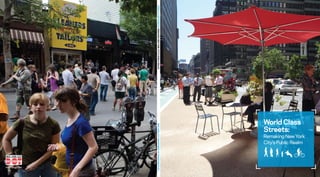
The document summarizes a report by the New York City Department of Transportation on improving New York City's public spaces and streets. It discusses trends in other world-class cities that have improved public spaces to encourage walking, biking, and use of public transportation. It also summarizes a public life survey conducted by Gehl Architects that examined how New Yorkers use public spaces. The goal is to make New York's streets among the most attractive in the world for walking, biking, and spending time outdoors.

Empfohlen
Empfohlen
Weitere ähnliche Inhalte
Andere mochten auch
Andere mochten auch (13)
Ähnlich wie World Class Streets Gehl 08
Ähnlich wie World Class Streets Gehl 08 (20)
Mehr von Glenn Klith Andersen
Mehr von Glenn Klith Andersen (20)
Kürzlich hochgeladen
Kürzlich hochgeladen (20)
World Class Streets Gehl 08
- 1. WORLD CLASS STREETS: REMAKING NEW YORK CITY’S PUBLIC REALM World Class Streets: Remaking New York City’s Public Realm World Class Streets: Remaking New York City’s Public Realm World Class NEW YORK CITY DEPARTMENT OF TRANSPORTATION Streets: Remaking New York City’s Public Realm www.nyc.gov/dot 2 3
- 2. World Class Streets: Remaking New York City’s Public Realm CONTENTS 2 Letter from the Mayor 3 Letter from Commissioner 6 World Class Streets: Remaking New York City's Public Realm 14 How Do People Use New York Streets? 36 New York City's World Class Streets Program 53 Acknowledgments 54 Additional Resources and Contacts 4 1
- 3. World Class Streets: Remaking New York City’s Public Realm World Class Streets: Remaking New York City’s Public Realm LETTER FROM ThE MAYOR LETTER FROM ThE COMMISSIONER Dear Friends: Dear fellow New Yorkers: In 2007, our Administration launched PlaNYC, our long Finally, it’s no accident that New York City’s merchant Famous images of New York nearly all emphasize the In this report, findings from a Public Space/Public Life term plan to create a greener, greater New York. One of communities focus heavily on streetscape quality city’s skyline—the high rise metropolis seen from a mile Survey conducted by the world-renowned Gehl the challenges PlaNYC poses to city agencies is to through their local Business Improvement Districts, distant or 5,000 feet up. Few who attempt to capture Architects/Urban Quality Consultants in Fall, 2007 “re-imagine the City’s public realm”— to develop an urban which we have worked hard to expand and support. For the city’s uniqueness or character in a single frame seek provide the starting point. Following Gehl’s analysis, we environment that transforms our streets and squares storefront businesses, welcoming, attractive streets can it from the most basic human point of view—that of the lay out the wide range of ambitious programs that into more people-friendly places. spell the difference between growth and just getting by. pedestrian walking down the street. NYCDOT has set in motion to change the city’s approach With 6,000 miles of City streets under its manage- Today, our Administration is dramatically extending the Why is this? In a look at Paris, for instance, the and that will allow us to build on New York City’s ment, the Department of Transportation is on the front streetscape improvements that many organizations have streetscapes of the Champs-Elysees and its central tremendous and ever-present potential. line of this effort— and it is succeeding in spectacular been able to create locally. pedestrian precincts will surely be featured. A view of fashion. New York has the most famous streets in the world. Barcelona will inevitably include a street-level Sincerely, Through new initiatives such as Broadway Boulevard, Now, we’re working to make them the most attractive perspective on Las Ramblas and of its new and re-made the Public Plaza Program, Coordinated Street Furniture, streets in the world for walking and cycling —and that public squares. and Summer Streets, we are finding creative new ways other great New York sport, people-watching. Until now, the City has not embraced a broad strategy to make our streets more attractive to pedestrians and for developing and caring for the public realm—the space cyclists—and those who wish to sit and relax and soak in Sincerely, between buildings—as an important element of public the City. This report outlines the challenges we face and policy. Indeed, despite so much change for the better Janette Sadik-Khan describes the many programs underway that are de- during the city’s renaissance of the past several decades, Commissioner signed to bring even more life to our World Class Streets. our streetscape remains broadly utilitarian, with little The business and environmental cases for improving change in appearance or feel from the 1970s. the quality of our public realm are clear. Streets that help World Class Streets amplifies the look at street design create and strengthen communities and businesses, in Michael R. Bloomberg in NYCDOT’s Sustainable Streets strategic plan, and will addition to connecting neighborhoods to one another, are Mayor serve as a companion volume to the new New York City an essential component of the City’s overall sustainabil- Street Design Manual we will issue in early 2009. ity strategy. Quality of life policies will enable the City to continue to grow its economy and retain more residents as they raise families and grow older, and it will even lead New Yorkers to spend more of the leisure time in the city. By attracting and retaining more residents, we will also help fight climate change. Mass transit- and pedestrian- oriented cities like New York help reduce suburban sprawl and the higher levels of carbon emissions that come with it. 2 3
- 4. World Class Streets: Remaking New York City’s Public Realm World Class Streets: Remaking New York City’s Public Realm 4 5
- 5. World Class Streets: Remaking New York City’s Public Realm World Class Streets: Remaking New York City’s Public Realm Public Realm/ World Class Street Strategies World Class Streets: — Plaza Program — New streetscape Remaking New York City’s materials — World class boulevards — Coordinated street — Complete streets furniture program Public Realm projects and design standards — Weekend pedestrian and cycling streets — Public art program This report is part of an ambitious and far reaching effort to place New Long Range New Transportation York at the forefront of urban development. It builds on two previous Sustainability Plan Policy & Priorities plans: PlaNYC, Mayor Bloomberg’s comprehensive sustainability plan, and Sustainable Streets, NYCDOT’s strategic plan. While the previous reports were comprehensive in scope, this document focuses solely on the NYCDOT public realm strategies listed at right. 6 7
- 6. World Class Streets: Remaking New York City’s Public Realm World Class Streets: Remaking New York City’s Public Realm Reimagining the city Cities are becoming greener and people-oriented Many cities today are using their public spaces in ways they haven’t in decades. During the twentieth century, many cities redesigned their central areas to better accommodate vehicular traffic and commuters who had moved to the suburbs. Today, however, many cities Place des Terreaux, Lyon. Ice skating at Sommerset House, London. Place del Paisos Catalans, Barcelona. Strøget, pedestrian priority street, Copenhagen. Federation Square, Melbourne. have rediscovered the advantages of their dense historic forms. In many, public life is being carefully supported through COPENHAGEN, DENMARK MELBOURNE, AUSTRALIA LYON, FRANCE LONDON, ENGLAND BARCELONA, SPAIN pedestrian, bicycling and public space improvements. People in all parts of the A better city, step by step Unified policy for vital, high- Coordinated public space policy Reducing traffic and generating Visionary thinking and world have responded enthusiastically to Copenhagen’s old main street was quality public streets The city of Lyon formulated a comprehensive revenue for the 100 public pioneering public space policy these new opportunities to celebrate the pedestrianized in 1962, marking the start public realm. In its street pattern and building mix, policy in 1989 to create more space for spaces program For the past two decades, Barcelona has of an extensive city renovation. Over the Melbourne is similar to other large cities. people. City planners created a large number When London introduced congestion pricing been the leading source of inspiration for next four decades, many of the streets and However, over the last few decades, while of parking spaces under newly renovated in 2003, it was one of the first steps towards architects, landscape architects, urban squares in the inner city were gradually other cities redesigned their streets to city squares, thus making efficient use of a more sustainable and people-friendly city. planners, and politicians who work with transformed into wholly or partially car-free accommodate the automobile and developed space and hiding a visually unappealing Traffic in the city center was reduced by public spaces. Nowhere in the world can so spaces. This created excellent conditions indoor shopping malls, Melbourne invited land use. In addition, the city has created a 15–20%, and revenue was generated for many examples of parks and squares be seen for walking and urban recreation in the city people to celebrate streets as the city’s design palette to be used in new projects. mass transit and public realm improvements. in one place. center. In addition, the gradual reduction most important public spaces. The city The renovation of the city’s main streets and At this time, London also created a plan Barcelona has been very imaginative in of parking has substantially reduced car renovated its pavements and street furniture squares was extended to the suburbs, where to become the world’s leading pedestrian implementing its public space policy. In the traffic in the city center. At the same time, a and developed a policy for active building several hundred urban improvement projects city. A key component is the goal to improve last decade, several hundred new parks, targeted policy to create better conditions facades to make walking an enjoyable have taken place. 100 public spaces. Other initiatives squares, and promenades have been created for bicycling has sustained a high level of experience. included planting one million new trees, by tearing down dilapidated apartment personal mobility. These renovations had tangible results: the development of a new streetscape buildings, warehouses and factories, and by from 1995 to 2005, Melbourne experienced renovating existing squares and regulating design manual, and several smaller scale a 40% increase in pedestrian traffic. The traffic to benefit pedestrians. interventions to improve the quality of the economic vitality of the city has improved pedestrian experience. proportionally—as evidenced by the increase in jobs, tax revenues, and property values. 8 8 9
- 7. 1 2 World Class Streets: Remaking New York City’s Public Realm World Class Streets: Remaking New York City’s Public Realm World Class Streets: Remaking New York City’s Public Realm New York’s huge potential New York streets are spacious enough to accommodate many users—cars, pedestrians, cyclists, delivery vehicles, buses and more. Traditionally, however, the streets have been designed primarily for motor vehicle traffic. This policy attracted an increasing number of vehicles, with negative effects on congestion and the overall quality of the public realm. But New York is a vibrant walking city with hundreds of major attractions. New Yorkers will take naturally to additional COMPACT LIVELY AND DIVERSE public spaces and well-designed, people- oriented streets. — High density — A vibrant city — Fine grained public transport — Cultural melting pot of the world network — A multitude of street parades, Trends in Public 3 4 — High volumes of pedestrians markets, fairs, etc — Efficient street grid — Millions of people on the street Space Activities in — High level of creativity the 21st century 1 Increased interest in sports and an active, healthy life style 2 Increased interest in participation in cultural events 3 Increased interest in amenities offered in the city like the waterfront, nature and fresh air 4 Increased interest in year-round outdoor activity FIRST CLASS PARKS ATTRACTIVE WATERWAYS — New Yorkers cherish their retreats — 600 miles of coastline from a hectic life — High quality river promenades — Central Park — Washington Square Park — Prospect Park and many more 10 11
- 8. World Class Streets: Remaking New York City’s Public Realm World Class Streets: Remaking New York City’s Public Realm A Walking (and Bicycling) City New Yorkers spend a lot of time in the public realm as a result of the city’s density, which promotes walking, public transit riding and, increasingly, bicycling. Improving walking conditions will benefit everyone in New York City, create more pleasant links between 10 min 20 min destinations and provide an environment that is enjoyable as well as functional. 5 min 10 min Most New Yorkers are never more than a 20 minute walk away from a subway or train station. 10 min 20 min 3 miles/h 10 min 20 min Pedestrian traffic New York has some of the highest volumes of 400 m 800 m 1200 m 1600 m 0,25 mile 0,5 mile 0,75 mile 1,0 mile pedestrians in the world., and New Yorkers flock to inviting public spaces, such as the hudson River Greenway, the car-free parks on weekends and the new public spaces that NYCDOT created along 5 min 10 min Broadway in Midtown Manhattan during 2008. 10 min 20 min 10 and 20 min walking catchment area to subway and train stations. 3 miles/h ca 9 miles/h 10 min 20 min 10 min 0m 400 m 800 m 1200 m 1600 m 0 mile 0.25 mile 0.5 mile 0.75 mile 1.0 mile 0m 400 m 800 m 1200 m 1600 m 2000 m 2400 m 0 mile 0.25 mile 0.5 mile 0.75 mile 1.0 mile 1.25 mile 1.5 mile Calculated Manhattan walking distances shown in minutes. Calculated Manhattan cycling distances shown in minutes. 12 13
- 9. World Class Streets: Remaking New York City’s Public Realm World Class Streets: Remaking New York City’s Public Realm How Do People Use New York Streets? Public Life Survey In 2007, New York City DOT contracted with Gehl Architects to conduct public life surveys of selected sites around the city. Gehl Architects/Urban Quality Consultants is an internationally renowned urban planning and design firm, and is credited with helping to turn Copenhagen into one of the most walkable and bikeable cities in the world. Gehl Architects has developed a unique field survey technique that quantifies how people use places in cities. For example, the company uses pedestrian count and stationary activity surveys to examine detailed information on where people walk and what they do when stationary, either as part of daily activities or for recreational purposes. Gehl’s data collectors also assess the quality and condition of outdoor seating, the quality of paving materials, construction-related impacts and other qualitative factors that affect the public realm. Results from the public life survey helped formulate much of the city’s strategy for improving streets as public spaces, and can serve as a baseline against which future surveys can be compared. 14 15
- 10. World Class Streets: Remaking New York City’s Public Realm World Class Streets: Remaking New York City’s Public Realm Method for measuring Survey Areas pedestrian traffic Selection of public life and public space survey areas This part of the study provides information on how much—and where—people walk, sit, stand or carry out The vast size and diversity of New York various stationary activities in the city. These are a City’s five boroughs and numerous good indicator of the quality of an urban space. neighborhoods make it impractical to A high number of pedestrians walking in a city survey the entire city in detail. Instead does not necessarily indicate a high-quality walking DOT suggested survey areas that are experience. however, if a large number of people centers of activity along key multi- choose to engage in voluntary activities (having an modal corridors. By studying these very outdoor lunch, playing, or sunbathing) then a city most different but vibrant centers of city likely has an excellent public realm. life, this survey provides snap shots of NYCDOT and Transportation Alternatives recruited the potentials and challenges found Broadway, Manhattan. East Fordham Road, Bronx. over 40 volunteers to assist the Gehl staff with data in the public realm of New York City collection in Fall 2007. NYCDOT and Gehl Architects today. The study team gained an overall conducted thorough volunteer orientation sessions understanding of pedestrian activities to ensure data was collected in accordance with the along key corridors in Brooklyn, the Bronx, methodology employed by Gehl Architects in cities Manhattan and Queens. These insights around the world. form part of the basis for NYCDOT's Gehl and NYCDOT are presently coordinating the public realm programs. training and transfer of the Public Space/Public Life survey methology to NYC agencies. Data Collection Locations/Conditions Gehl chose specific locations near key Gehl has used its method in intersections and major destinations. studies in London, Sydney, They were chosen to investigate special conditions in each neighborhood as well Perth, Adelaide, Melbourne, as typical conditions that can be applied to much of each borough. Data was Wellington, Rotterdam, Dublin, collected from 8am–8pm during a series Flatbush Ave, Brooklyn. 34th Street, Manhattan. Riga, Stockholm, Oslo and of weekdays in October under good weather conditions. Copenhagen. Surveyors counted pedestrians on streets for 10 minutes every hour between 8 a.m. and 8 p.m. Soho, Spring Street, Manhattan. Main Street, Flushing. 16 17
- 11. World Class Streets: Remaking New York City’s Public Realm World Class Streets: Remaking New York City’s Public Realm Comparison of weekday pedestrian traffic between 8 am–8 pm New York City is a world-class walking city. Pedestrian volumes on major streets in New York exceed those found in cities like London, Sydney, and Copenhagen. Moreover, high pedestrian volumes are found throughout the city, not just in Manhattan. One of the most striking findings of this survey is that some main streets in Queens and the Bronx have greater numbers of pedestrians than the centers of major European cities. For example, pedestrian volumes on Flushing’s Main Street are about 70% higher than those found on Regent Street in Central London. Pedestrian volumes PEDESTRIAN TRAFFIC COMPARISON on Flushing’s Main TIMES SqUARE, 2007 EAST FORDHAM ROAD, BRONx, 2007 FLUSHING MAIN ST, qUEENS, 2007 Street are about INTERNATIONAL 118,000 80,570 97,290 Sydney, George St 54,600 2007 70% higher than Total length surveyed: 3.4 miles Total length surveyed: 1.1 miles Total length surveyed: 0.8 miles Melbourne, Swanston St (south) 51,580 2004 those found on Street width: 69–102 feet Street width: 99 feet Street width: 100 feet Stockholm, Drottninggatan 55,830 2005 Regent Street in Footpath width: 14–20 feet Footpath width: 19 feet Footpath width: 15–16.5 feet Copenhagen, Strøget 58,500 2005 Central London. Status: Shopping and entertainment Status: Shopping street and main public Status: Shopping street and main public street and a north-south vehicular link transportation and vehicular link transportation and vehicular link London, Regent St 57,320 2002 London, Oxford St 129,840 2002 NEW YORK Times Square 118,000 2007 (Broadway & 7th Ave at 44th St) 8th Ave btw 33rd & 34th St 100,740 2007 34th St near 6th Ave 94,730 2007 5th Ave btw 21st and 22nd 31,850 2007 14th St btw 5th Ave & University Place 51,580 2007 Broadway btw Prince and Spring 48,940 2007 Flatbush Ave, Brooklyn 12,520 2007 East Fordham Road, Bronx 80,570 2007 Flushing Main St, Queens 97,290 2007 0 25,000 50,000 75,000 100,000 125,000 150,000 SYDNEY, GEORGE STREET, 2007 LONDON, OxFORD STREET, 2007 COPENHAGEN, STRøGET, 2005 Major streets in other cities New York 54,600 129,830 58,500 Weekday pedestrian traffic between 8 am–8 pm Weekday pedestrian traffic between 8 am–8 pm Total length: 1.6 miles Total length: 0.30 miles Total length: 0.75 miles Street width: 72–98 feet Street width: 56–92 feet Street width: 33–39 feet Footpath width: 16–20 feet Footpath width: 10–39 feet Footpath width: 33–39 feet Status: Main shopping street with Status: Shopping street with large Status: Main street dominated by heavy traffic numbers of pedestrians and vehicles shopping, cafes and restaurants 18 19
- 12. World Class Streets: Remaking New York City’s Public Realm World Class Streets: Remaking New York City’s Public Realm Congested Sidewalks The sidewalks on Gehl Architects’ studies from around the world Flushing Main St. SignS of crowded SidewalkS suggest that the maximum volume for comfortable are overcrowded pedestrian movement is 12 people per minute per yard of sidewalk width. Anything above this 83% of the day level is considered to be overcrowding. (Other methodologies assess crowding according to the number of people that a street can carry—however such methodologies deal only with capacity and not quality). When Copenhagen’s main street, Strøget, Problems with reaches the level of 12 persons per minute per yard overcrowded sidewalks people start finding alternative routes. This has been the case for the last 30 years. Despite the fact that sidewalk widths are Crowding is generally: generous in some parts of the city, key sections BAD FOR COMMERCE of street simply do not accommodate the volume since people have difficulty stopping/ of pedestrian traffic. In New York, people walking looking at window displays. compete for space with those waiting at bus stops, and with the many physical items on sidewalks. BAD FOR SAFETY Flushing Main Street. since fast walking pedestrians will move out onto the road or people will accidentally be pushed into the road. BAD FOR THOSE WITH SPECIAL NEEDS Overcrowded crosswalk. since those in wheelchairs, parents with strollers, people with disabilities, children and the elderly Crowding is a sign of low generally need more space for walking than that available on a crowded footpath. These groups can walking quality. When be deterred from walking under such conditions. crowding occurs, walking BAD FOR ENCOURAGING PEOPLE TO WALK turns into a fight to get since people will avoid walking if it is unpleasant to do so. from one point to another. The sidewalks on East Fordham Road are overcrowded 54% of the day East Fordham Road. People do not have space to wait at crossings. 20 21
- 13. World Class Streets: Remaking New York City’s Public Realm World Class Streets: Remaking New York City’s Public Realm VOLUMES ON FLUSHING MAIN STREET In cases such as Flushing Main St, the number of pedestrians is nearly twice that of vehicle passengers, yet pedestrians are provided less than one third the space. SPACE ON FLUSHING MAIN STREET FLUSHING MAIN STREET, QUEENS bETWEEN ROOSEvELT AND 41ST AvE Pedestrians are pushed into the road when waiting for a green light. East sidewalk West sidewalk In some locations, only 50% of the sidewalk on Broadway is possible to use for walking. Sidewalk 16’ 0 Obstacles on Sidewalks Sidewalk 16’ 11’ 11’ 11’ 11’ 11’ 11’ 200cm 400cm 600cm effective effective The effective width for walking is width 13’ width 13’ sometimes 50% of the sidewalk Pedestrians The numerous obstacles found on New York City 46,140 56,000 51,150 sidewalks further contribute to crowding and hurt the Vehicular passengers quality of the pedestrian experience. Vendors and street pedestrians / motorists and bus pedestrians / 8 am–8 pm passengers a day utilize 8 am–8 pm furniture play a key role in the public life of the City, but effective width 13’ the roadway, effective effective width 13’ often unregulated vendors and poorly placed or planned On very crowded sidewalks, street vendors may cause further problems. width 65 feet furniture restrict pedestrian access. Often the most crowded areas (such as sidewalks near subway stops and street corners) are the places where the most obstacles exist. At some street corners, multiple trash cans or newsboxes force people into traffic. Cluttered sidewalks SIDEWALK 16’ 11’ 11’ 11’ 11’ 11’ SIDEWALK 16’ not only impede access but also negatively affect the 13’ visual environment. 22 23
- 14. World Class Streets: Remaking New York City’s Public Realm World Class Streets: Remaking New York City’s Public Realm Crowding on Broadway when students are waiting for the bus. No protection against unpleasant weather makes the time waiting uncomfortable. Sidewalk Crowding Affects Public Transit Streets without seats It is sometimes hard to get Nowhere to rest to the subway or bus There are very few places for people to New York City has one of the world’s best public sit and rest, meet and interact or people- transit systems. Unfortunately, the well-used system watch along the streets of New York City. is not accessible to all city residents and visitors. At A vastly disproportionate amount of space some locations, sidewalks are not broad enough to is allocated to parking cars than to public accomodate the flow in and out of busy subway stops. Limited space for access to and from public transportation.. seating spaces. While New York City The few public seating opportunities in the streets are of poor quality and exposed to traffic. At others, those waiting for the bus must wait in the provides some of the best urban scenery sun or rain because of a lack of shelters. In addition, at in the world, there are simply very few some outer locations, busy bus stops lack sidewalks, places to stop, enjoy and soak in the unique thus making access difficult, if not impossible, for the atmosphere. disabled, elderly, and those pushing strollers. Few resting opportunities while waiting for public transportation excludes some user groups. People find alternative seating where nothing else is provided. 24 25
- 15. C Central Park World Class Streets: Remaking New York City’s Public Realm Columbus Circle 57th Stree t ue 8 Th Aven More scaffolding than seating 7th Avenue Paramount Plaza Scaffolding is left up for too long, while street cafes are few and far between Times Square 6th Avenue New York is falling behind other cities in the provision Grand Central of outdoor seating opportunities. Research from around Station Bryant Park the world indicates that there is incredible demand for café seating. For example, in London, Copenhagen, 42nd Stree t and Melbourne, restaurants have found that increased Golda Mayer outdoor seating options leads to increased business. The Place positive effects of providing café seating go beyond the benefits to individual restaurant owners, as café seating Herald contributes to an improved public realm, and increased Square economic vitality for a city. It is a cause for concern that 34th Stree the three- mile stretch of Broadway from Columbus Circle Penn t Station Greeley Square to houston Street, one of the City’s leading thoroughfares, has only 6 outdoor cafes. While the city suffers from a shortage of outdoor seating, it is a global leader in scaffolding. The amount 5th Avenue NUMBER OF CAFE SEATS PER 1000 YD of building and renovation underway makes scaffolding a necessity to protect pedestrians. An unintended Copenhagen, Strøget 444 consequence of recent legislation designed to protect people from building façades with potential problems has Melbourne, Swanston St Worth Madison 353 Square Square Park been the vast proliferation of long-duration scaffolding that narrows, darkens and uglifies potentially vibrant London, Regent St 23rd Stree 137 t sidewalks.Although scaffolding is a necessity to protect pedestrians from construction activities, in some cases New York, Broadway 15 it is put up far in advance of actual work, or left standing ue long after it is necessary. For example, scaffolding covers 0 100 200 300 400 500 Park Aven 30% of the buildings along the three miles of Broadway from Columbus Circle to houston Street. Union Square 14th Stree Café outdoor seating on the street curb side t Café outdoor seating in public space 30% of Broadway buildings There are only 6 curb side Public seating in the street between Columbus Circle outdoor cafés on Broadway Public seating in public space Washington Astor Place and Houston St are covered between Columbus Circle Square with scaffolding. and Soho. Houston Street Prince and Spring Street 26 27
- 16. World Class Streets: Remaking New York City’s Public Realm World Class Streets: Remaking New York City’s Public Realm Few Opportunities to Stop EXAMPLES OF ACTIvITIES Allocation of space for things PRINCE ST BETWEEN WEST BROADWAY AND LAFAYETTE at rest on Prince Street: 73% for cars 3% for people PRINCE AND 24% for bicycles SPRING STREET Prince St ay roadw West B er St e St Woost Green r St Sitting on café chairs. Sitting on secondary seating. Merce way Broad y St Crosb Parking Spaces Parked Bicycles Public Seating Parking Spaces 64 Commercial activities. Standing. Parked Bicycles 21 With the exception of Flushing Main Street,the areas surveyed in The type of stationary activities found in New York’s streets are New York have a significantly lower ratio of stationary activities very different than those found in other world cities. A majority of per 100 yards of street compared to other capital cities. Sitting the stationary activities recorded on Flushing’s Main Street are Public Seating Spaces 1 activities are especially few in New York. commercial activities associated with street vendors. The majority 0 20 40 60 80 of the stationary activities recorded along Swanston Street in Melbourne, by contrast, are associated with people window shopping or relaxing in public benches, café chairs and/or secondary seating. 28 29
- 17. World Class Streets: Remaking New York City’s Public Realm World Class Streets: Remaking New York City’s Public Realm Few children and % OF PEDESTRIANS % OF PEDESTRIANS elderly in the street UNDER 14 OvER 65 Who uses New York streets? 4% 2% Overcrowded or otherwise unattractive sidewalks and walking environments are not only less pleasant broadway places to be, they in fact discourage some groups from walking or being on a public street altogether. Only 10% of pedestrians identified at our survey sites were children or seniors 6% 0% (under 14 or over 65 years old), although these groups account for a combined Flatbush Ave 30% of New York’s population The elderly and young are SURvEY AREA rarely seen in the street environment in places 12% 2% where streets are traffic East Fordham Road dominated and are not perceived as safe. 5% 10% Flushing Main St 30 31
- 18. W 48 St World Class Streets: Remaking New York City’s Public Realm World Class Streets: Remaking New York City’s Public Realm W 48 St 7th Ave W 47 St Times Square W 47 St consists of 89% road space Broadway 11% people space W 46 St Times Square Total area: 183,000 sq ft Little Braz il Street Pedestrian area: 20,200 sq ft Few people ever visit the plaza around the arch in Brooklyn’s Grand Army Plaza. Many Public Spaces are Hard to Get to W 45 St Many public spaces do not interact with streets and surrounding buildings W 45 St New Yorkers rarely experience the joy of coming across a break in the streetscape- an inviting public space along their journey from Point A to Point B. Instead, they are forced to make a deliberate decision to reach an island of public Broadway 7th Ave space- and to get to that island, they often need to negotiate complicated and busy crossings. W 44 St Once there, they find none of the opportunities to interact herald Square is a hidden oasis in the middle of traffic. with the indoor environment that a building edge provides. W 44 St Indoor activities are not allowed to spill into the public realm (and vice versa) because so few public spaces are actually Times Square at night. People are crowded on a narrow traffic bordered by a building. Instead, the only influence at the island in a traffic dominated space. Recent NYCDOT projects to border of a public space is often a street full of traffic. create more space for people in Madison Square and on Broadway herald and Greeley Squares are a classic example of this north of 34th Street (see pages 39 and 40) may have future phenomenon. In an effort to protect them from adjacent application along Broadway north of 42nd Street. traffic, planners have surrounded each square with trees, W 43 St hedges, and walls. As a result, the plazas are visually and physically detached from the pedestrian flow on the W 43 St sidewalks. The vitality of one space does nothing to feed the other. The lack of visual connections and natural pedestrian flow through the spaces makes them more unsafe at night, and as a result these spaces, and many like them across the City, are closed after dark. Additionally, most of the actual space in herald Square is active street space for motor vehicles. 82% of the'square' is taken up by busy through streets. Similar conditions are W 42 St found in Times Square. 32 W 42 St 33