SlideShare ist ein Scribd-Unternehmen logo
1 von 20
SHANNON PARK REDEVELOPMENT PLAN
REMODELING WITH ESRI CITYENGINE
presented by JING YAN
CENTRE OF GEOGRAPHIC SCIENCES CAPSTONE PROJECT
Table of Contents
 Background
 Goals and Objectives
 Esri CityEngine Essentials
 Project Stages
1. Data Preparation
2. 3D Community Auto-generation Scenarios
3. Redevelopment Plan Remodeling
4. Web Scene Publishing
 Discussion
(Image Source: www.smarterbettercities.ch)
Background
 Shannon Park, Dartmouth, NS
 42 hectare
 Abandoned military community
 Ownerships
 Significant potentials
 2010 Redevelopment Proposal
 Urban planning school project
 2D and 3D products
Shannon
Park
Dartmouth
Shannon Park Boundary
(Source: 2015 DigitalGlobe)
SketchUp Model
2010 Shannon Park
Redevelopment Proposal
2D and 3D Products
Goals and Objectives
 The project has a two-fold goal: 1)
to explore 3D GIS application in
urban planning and community design,
and 2) to explore Esri CityEngine as
a powerful tool of building 3D
communities.
 To achieve this, the stage-by-stage
objectives aim at converting the 2010
redevelopment plan into a realistic
3D model with Esri CityEngine.
Top View
2015 Shannon Park CityEngine Model
Esri CityEngine Essentials
 Dynamic City Layouts
 Interactive street networks
 Geometries updated on the fly
 Grammar-based Modeling
 Procedural modeling vs. Hand crafting
 Computer Generated Architecture(CGA)
 Basic Workflow inside CityEngine
Geographical &
control maps
• Import
Street network
(centerlines)
• Generate
• Draw
• Import
• Edit
Lots
• Generate
• Import
• Edit
Buildings
• Generate
• Import
• Polygonal
Modeling
Street
Furniture
• Generate
• Import
Final Products
• Web Scene
Model
• Report
• Geodatabase
CGA Simple Sample
Project Stage 1
Data Preparation
Data Format Post-processed Product
Raster
Height Map (DEM) Contours 1m, Spot Heights DWG Georeferenced TIFF
Texture ArcGIS Imagery Basemap Raster Georeferenced TIFF
Obstacle Map Black and White Imagery Raster Georeferenced TIFF
2D
Vector
Streets Street Centerlines DWG Line Feature Class
Parcels Property Lines DWG Polygon Feature Class
Building Footprints Building Polygons DWG Polygon Feature Class
Trees Tree Points DWG Point Feature Class
Boundary Shannon Park Property Line Feature Class Polygon Feature Class
3D Mesh Buildings Raw Building Models SketchUp File DAE Files
Images
Facade
Photographs, CityEngine
Library
JPEG, PNG JPEG, PNG
Pavement
Web Images, CityEngine
Library
JPEG, PNG JPEG, PNG
Shannon Park School
Facade Samples
Project Stage 2
3D Community Auto-generation Scenarios
 Levels of Import/Auto-Generation
 Import Height Map, Texture, and Obstacle Map
 Plus Streets, and Lots
 Plus Building footprints
 CGA Generated Scenes
 International
 Sci-fi
 Map Layer Usage
 With Height Control Map
 Without
Height Map, Texture, and Obstacle Map (from left to right)
CGA Generated Scene - International
CGA Generated Scene - Sci-Fi
Height Control Example
CGA Generated Scene - Schematic
Height Map
CGA Generated Scene - Schematic
SHORE
SHORE
SHORE
Project Stage 3
Redevelopment Plan Remodeling
 Work with Streets
 Import street centerlines; align to terrain
 Edit layer attributes (widths, types, sidewalks, etc.)
 Apply CGA rules
 Modify streets (nodes, curves, etc.)
Import Height
Map and
Texture Image
Work with
Streets
Work with Lots
Work with
Buildings
Work with
Street Texture
and Furniture
Workflow
Streets Colored by
Type
 Work with Lots
 Import lot polygons
 Align to terrain and streets
 Edit layer attributes (types)
 Apply CGA rules
Import Height
Map and
Texture Image
Work with
Streets
Work with Lots
Work with
Buildings
Work with
Street Texture
and Furniture
Workflow
Lots with Texture
 Work with Buildings
 Import building footprint polygons
 Edit layer attributes (types and heights)
 Apply CGA rules
 Polygonal modeling (Shannon Park School, and Townhouses)
Import Height
Map and
Texture Image
Work with
Streets
Work with Lots
Work with
Buildings
Work with
Street Texture
and Furniture
Workflow
Buildings by Rules and Modeling
Shannon Park School
Townhouses
 Work with Street Texture and Furniture
 Apply CGA rules to each street type
 General, Transit, Bikeway, and Walkway
 Adjust street attributes based on street types
Import Height
Map and
Texture Image
Work with
Streets
Work with Lots
Work with
Buildings
Work with
Street Texture
and Furniture
Workflow
Transit Route
Bikeway
Project Stage 4
Web Scene Publishing
 Three Steps
 Prepare scene (bookmarks, cameras, scene light, etc.)
 Export to model (groups, layer visibility, metadata, etc.)
 Publish to ArcGIS Online
 Web Scene User Interface
 Map Control
 Layer control (turn on/off, swipe)
 Search by attributes
 Scene settings
 Comments and Information
Published Web Scene
http://arcg.is/1PFXhYW
Discussion
 3D GIS in Urban Planning and Community Design
 Software
 Autodesk Products, SketchUp, MicroStation
 ArcScene, ArcGlobe, ArcGIS Pro
 Esri CityEngine
 3D City Models
 Google Earth landmarks
 Toronto 3D Massing open data ►►►
 Urban Planning Applications
 Zoning
 Development proposal in context
 Auto-generated reports
Toronto in 3D with Height Zoning
(Source: www.geoplanit.co.uk/?p=2779)
THANK YOU!

Weitere ähnliche Inhalte

Was ist angesagt?

Integrating Virtual Environment and GIS for 3D Virtual City.ppt
Integrating Virtual Environment and GIS for 3D Virtual City.pptIntegrating Virtual Environment and GIS for 3D Virtual City.ppt
Integrating Virtual Environment and GIS for 3D Virtual City.pptgrssieee
 
Use of CityGML standard in the context of Smart City
Use of CityGML standard in the context of Smart CityUse of CityGML standard in the context of Smart City
Use of CityGML standard in the context of Smart Cityi-SCOPE Project
 
Enabling numerical Simulations in semantic 3D City Models using CityGML
Enabling  numerical Simulations in  semantic 3D City Models using CityGMLEnabling  numerical Simulations in  semantic 3D City Models using CityGML
Enabling numerical Simulations in semantic 3D City Models using CityGMLvirtualcitySYSTEMS GmbH
 
3D enabling Smart Cities
3D enabling Smart Cities3D enabling Smart Cities
3D enabling Smart Citiesi-SCOPE Project
 
3D Web Services And Models For The Web: Where Do We Stand?
3D Web Services And Models For The Web: Where Do We Stand?3D Web Services And Models For The Web: Where Do We Stand?
3D Web Services And Models For The Web: Where Do We Stand?Camptocamp
 
UI/UX for Indoor/Outdoor Seamless Navigation?
UI/UX for Indoor/Outdoor Seamless Navigation?UI/UX for Indoor/Outdoor Seamless Navigation?
UI/UX for Indoor/Outdoor Seamless Navigation?SANGHEE SHIN
 
GeoVisualization of My Home Neighborhood
GeoVisualization of My Home NeighborhoodGeoVisualization of My Home Neighborhood
GeoVisualization of My Home NeighborhoodMatthew Mittler
 
Embedding user generated content into oblique airborne photogrammetry based 3...
Embedding user generated content into oblique airborne photogrammetry based 3...Embedding user generated content into oblique airborne photogrammetry based 3...
Embedding user generated content into oblique airborne photogrammetry based 3...Jianming Liang
 
Current State of mago3D, an Open Source Based Digital Twin Platform
Current State of mago3D, an Open Source Based Digital Twin PlatformCurrent State of mago3D, an Open Source Based Digital Twin Platform
Current State of mago3D, an Open Source Based Digital Twin PlatformSANGHEE SHIN
 
mago3D, A Brand-New Web Based Open Source GeoBIM Platform
mago3D, A Brand-New Web Based Open Source GeoBIM Platformmago3D, A Brand-New Web Based Open Source GeoBIM Platform
mago3D, A Brand-New Web Based Open Source GeoBIM PlatformSANGHEE SHIN
 
Introduction to mago3D: A Web Based Open Source GeoBIM Platform
Introduction to mago3D: A Web Based Open Source GeoBIM PlatformIntroduction to mago3D: A Web Based Open Source GeoBIM Platform
Introduction to mago3D: A Web Based Open Source GeoBIM PlatformSANGHEE SHIN
 
Let's integrate CAD/BIM/GIS on the same platform: A practical approach in rea...
Let's integrate CAD/BIM/GIS on the same platform: A practical approach in rea...Let's integrate CAD/BIM/GIS on the same platform: A practical approach in rea...
Let's integrate CAD/BIM/GIS on the same platform: A practical approach in rea...SANGHEE SHIN
 
City of Vancouver CAD - GIS - 3D Integration A Dimension Too Far?
City of Vancouver CAD - GIS - 3D Integration A Dimension Too Far?City of Vancouver CAD - GIS - 3D Integration A Dimension Too Far?
City of Vancouver CAD - GIS - 3D Integration A Dimension Too Far?Andrew Bashfield
 
State of mago3D, An Open Source Based Digital Twin Platform
State of mago3D, An Open Source Based Digital Twin PlatformState of mago3D, An Open Source Based Digital Twin Platform
State of mago3D, An Open Source Based Digital Twin PlatformSANGHEE SHIN
 
Unified Geometry Modelling for Pervasive Design and Fabrication
Unified Geometry Modelling for Pervasive Design and FabricationUnified Geometry Modelling for Pervasive Design and Fabrication
Unified Geometry Modelling for Pervasive Design and FabricationLiu PeiLing
 
Making Beautiful Maps: Oct 5 2011
Making Beautiful Maps: Oct 5 2011Making Beautiful Maps: Oct 5 2011
Making Beautiful Maps: Oct 5 2011Jake Levitas
 
What I've learned from implementing GeoBIM in real cases
What I've learned from implementing GeoBIM in real casesWhat I've learned from implementing GeoBIM in real cases
What I've learned from implementing GeoBIM in real casesSANGHEE SHIN
 
What is 3d rendering
What is 3d renderingWhat is 3d rendering
What is 3d renderingSandeep Kumar
 

Was ist angesagt? (20)

Integrating Virtual Environment and GIS for 3D Virtual City.ppt
Integrating Virtual Environment and GIS for 3D Virtual City.pptIntegrating Virtual Environment and GIS for 3D Virtual City.ppt
Integrating Virtual Environment and GIS for 3D Virtual City.ppt
 
Use of CityGML standard in the context of Smart City
Use of CityGML standard in the context of Smart CityUse of CityGML standard in the context of Smart City
Use of CityGML standard in the context of Smart City
 
Enabling numerical Simulations in semantic 3D City Models using CityGML
Enabling  numerical Simulations in  semantic 3D City Models using CityGMLEnabling  numerical Simulations in  semantic 3D City Models using CityGML
Enabling numerical Simulations in semantic 3D City Models using CityGML
 
3D enabling Smart Cities
3D enabling Smart Cities3D enabling Smart Cities
3D enabling Smart Cities
 
3D Web Services And Models For The Web: Where Do We Stand?
3D Web Services And Models For The Web: Where Do We Stand?3D Web Services And Models For The Web: Where Do We Stand?
3D Web Services And Models For The Web: Where Do We Stand?
 
UI/UX for Indoor/Outdoor Seamless Navigation?
UI/UX for Indoor/Outdoor Seamless Navigation?UI/UX for Indoor/Outdoor Seamless Navigation?
UI/UX for Indoor/Outdoor Seamless Navigation?
 
GeoVisualization of My Home Neighborhood
GeoVisualization of My Home NeighborhoodGeoVisualization of My Home Neighborhood
GeoVisualization of My Home Neighborhood
 
Embedding user generated content into oblique airborne photogrammetry based 3...
Embedding user generated content into oblique airborne photogrammetry based 3...Embedding user generated content into oblique airborne photogrammetry based 3...
Embedding user generated content into oblique airborne photogrammetry based 3...
 
Current State of mago3D, an Open Source Based Digital Twin Platform
Current State of mago3D, an Open Source Based Digital Twin PlatformCurrent State of mago3D, an Open Source Based Digital Twin Platform
Current State of mago3D, an Open Source Based Digital Twin Platform
 
mago3D, A Brand-New Web Based Open Source GeoBIM Platform
mago3D, A Brand-New Web Based Open Source GeoBIM Platformmago3D, A Brand-New Web Based Open Source GeoBIM Platform
mago3D, A Brand-New Web Based Open Source GeoBIM Platform
 
Introduction to mago3D: A Web Based Open Source GeoBIM Platform
Introduction to mago3D: A Web Based Open Source GeoBIM PlatformIntroduction to mago3D: A Web Based Open Source GeoBIM Platform
Introduction to mago3D: A Web Based Open Source GeoBIM Platform
 
Reviewer in com graphics
Reviewer in com graphicsReviewer in com graphics
Reviewer in com graphics
 
Let's integrate CAD/BIM/GIS on the same platform: A practical approach in rea...
Let's integrate CAD/BIM/GIS on the same platform: A practical approach in rea...Let's integrate CAD/BIM/GIS on the same platform: A practical approach in rea...
Let's integrate CAD/BIM/GIS on the same platform: A practical approach in rea...
 
City of Vancouver CAD - GIS - 3D Integration A Dimension Too Far?
City of Vancouver CAD - GIS - 3D Integration A Dimension Too Far?City of Vancouver CAD - GIS - 3D Integration A Dimension Too Far?
City of Vancouver CAD - GIS - 3D Integration A Dimension Too Far?
 
State of mago3D, An Open Source Based Digital Twin Platform
State of mago3D, An Open Source Based Digital Twin PlatformState of mago3D, An Open Source Based Digital Twin Platform
State of mago3D, An Open Source Based Digital Twin Platform
 
Unified Geometry Modelling for Pervasive Design and Fabrication
Unified Geometry Modelling for Pervasive Design and FabricationUnified Geometry Modelling for Pervasive Design and Fabrication
Unified Geometry Modelling for Pervasive Design and Fabrication
 
3D Plan
3D Plan3D Plan
3D Plan
 
Making Beautiful Maps: Oct 5 2011
Making Beautiful Maps: Oct 5 2011Making Beautiful Maps: Oct 5 2011
Making Beautiful Maps: Oct 5 2011
 
What I've learned from implementing GeoBIM in real cases
What I've learned from implementing GeoBIM in real casesWhat I've learned from implementing GeoBIM in real cases
What I've learned from implementing GeoBIM in real cases
 
What is 3d rendering
What is 3d renderingWhat is 3d rendering
What is 3d rendering
 

Andere mochten auch

FInal Project MGMT 404
FInal Project MGMT 404FInal Project MGMT 404
FInal Project MGMT 404Steven Quenzel
 
North Street Park Grant Application LCF
North Street Park Grant Application LCFNorth Street Park Grant Application LCF
North Street Park Grant Application LCFRichard J. Lott
 
New Eyes on the Old World
New Eyes on the Old WorldNew Eyes on the Old World
New Eyes on the Old WorldEsri
 
Esriuk_track2_garsdale_design_mindthegap
Esriuk_track2_garsdale_design_mindthegapEsriuk_track2_garsdale_design_mindthegap
Esriuk_track2_garsdale_design_mindthegapEsri UK
 
SOLAR FINAL DOC (3)
SOLAR FINAL DOC (3)SOLAR FINAL DOC (3)
SOLAR FINAL DOC (3)Wes Shaffer
 
0809 Presentation Startupday.02
0809 Presentation Startupday.020809 Presentation Startupday.02
0809 Presentation Startupday.02dtarolli
 
From Flat to Stacked - Alicia C Newberry - City of Milton
From Flat to Stacked - Alicia C Newberry - City of MiltonFrom Flat to Stacked - Alicia C Newberry - City of Milton
From Flat to Stacked - Alicia C Newberry - City of MiltonAlicia Newberry
 
Application of integrated System Dynamics, GIS and 3D visualization system in...
Application of integrated System Dynamics, GIS and 3D visualization system in...Application of integrated System Dynamics, GIS and 3D visualization system in...
Application of integrated System Dynamics, GIS and 3D visualization system in...Beniamino Murgante
 
A New Dimension
A New DimensionA New Dimension
A New DimensionEsri
 
Towards the development of a virtual 3D city model: Dundalk, Ireland
Towards the development of a virtual 3D city model: Dundalk, IrelandTowards the development of a virtual 3D city model: Dundalk, Ireland
Towards the development of a virtual 3D city model: Dundalk, Ireland IES VE
 
Alpha Case Study - Project Management Plan Sample
Alpha Case Study - Project Management Plan SampleAlpha Case Study - Project Management Plan Sample
Alpha Case Study - Project Management Plan SampleAgatha Maia Duarte de Assis
 
BIM - Esri UK Annual Conference 2016
BIM - Esri UK Annual Conference 2016BIM - Esri UK Annual Conference 2016
BIM - Esri UK Annual Conference 2016Esri UK
 
Leveraging ArcGIS Platform & CityEngine for GIS based Master Plans
Leveraging ArcGIS Platform & CityEngine for GIS based Master PlansLeveraging ArcGIS Platform & CityEngine for GIS based Master Plans
Leveraging ArcGIS Platform & CityEngine for GIS based Master PlansEsri India
 

Andere mochten auch (20)

FInal Project MGMT 404
FInal Project MGMT 404FInal Project MGMT 404
FInal Project MGMT 404
 
North Street Park Grant Application LCF
North Street Park Grant Application LCFNorth Street Park Grant Application LCF
North Street Park Grant Application LCF
 
8. project risk management
8. project risk management8. project risk management
8. project risk management
 
New Eyes on the Old World
New Eyes on the Old WorldNew Eyes on the Old World
New Eyes on the Old World
 
Esriuk_track2_garsdale_design_mindthegap
Esriuk_track2_garsdale_design_mindthegapEsriuk_track2_garsdale_design_mindthegap
Esriuk_track2_garsdale_design_mindthegap
 
Project ViCiTiS
Project ViCiTiSProject ViCiTiS
Project ViCiTiS
 
SOLAR FINAL DOC (3)
SOLAR FINAL DOC (3)SOLAR FINAL DOC (3)
SOLAR FINAL DOC (3)
 
0809 Presentation Startupday.02
0809 Presentation Startupday.020809 Presentation Startupday.02
0809 Presentation Startupday.02
 
From Flat to Stacked - Alicia C Newberry - City of Milton
From Flat to Stacked - Alicia C Newberry - City of MiltonFrom Flat to Stacked - Alicia C Newberry - City of Milton
From Flat to Stacked - Alicia C Newberry - City of Milton
 
Application of integrated System Dynamics, GIS and 3D visualization system in...
Application of integrated System Dynamics, GIS and 3D visualization system in...Application of integrated System Dynamics, GIS and 3D visualization system in...
Application of integrated System Dynamics, GIS and 3D visualization system in...
 
Petro 3D Cartoon
Petro 3D CartoonPetro 3D Cartoon
Petro 3D Cartoon
 
Oil&gas projects
Oil&gas projectsOil&gas projects
Oil&gas projects
 
Urban Design Simulation with utilizing CityEngine and SiteOps
Urban Design Simulation with utilizing CityEngine and SiteOpsUrban Design Simulation with utilizing CityEngine and SiteOps
Urban Design Simulation with utilizing CityEngine and SiteOps
 
A New Dimension
A New DimensionA New Dimension
A New Dimension
 
Towards the development of a virtual 3D city model: Dundalk, Ireland
Towards the development of a virtual 3D city model: Dundalk, IrelandTowards the development of a virtual 3D city model: Dundalk, Ireland
Towards the development of a virtual 3D city model: Dundalk, Ireland
 
Master Planning Cities (with the help of CityEngine) (Elliot Hartley, Garsdal...
Master Planning Cities (with the help of CityEngine) (Elliot Hartley, Garsdal...Master Planning Cities (with the help of CityEngine) (Elliot Hartley, Garsdal...
Master Planning Cities (with the help of CityEngine) (Elliot Hartley, Garsdal...
 
MGMT_404 PROJECT FINAL
MGMT_404 PROJECT FINALMGMT_404 PROJECT FINAL
MGMT_404 PROJECT FINAL
 
Alpha Case Study - Project Management Plan Sample
Alpha Case Study - Project Management Plan SampleAlpha Case Study - Project Management Plan Sample
Alpha Case Study - Project Management Plan Sample
 
BIM - Esri UK Annual Conference 2016
BIM - Esri UK Annual Conference 2016BIM - Esri UK Annual Conference 2016
BIM - Esri UK Annual Conference 2016
 
Leveraging ArcGIS Platform & CityEngine for GIS based Master Plans
Leveraging ArcGIS Platform & CityEngine for GIS based Master PlansLeveraging ArcGIS Platform & CityEngine for GIS based Master Plans
Leveraging ArcGIS Platform & CityEngine for GIS based Master Plans
 

Ähnlich wie Shannon Park Redevelopment Plan Remodeling with Esri CityEngine

Engineering Art at Autodesk University 2013
Engineering Art at Autodesk University 2013 Engineering Art at Autodesk University 2013
Engineering Art at Autodesk University 2013 TheDewberryWay
 
City focus: A web-based interactive 2D and 3D GIS application to find the bes...
City focus: A web-based interactive 2D and 3D GIS application to find the bes...City focus: A web-based interactive 2D and 3D GIS application to find the bes...
City focus: A web-based interactive 2D and 3D GIS application to find the bes...Carolina Arias Muñoz
 
3D Visualization in ArcGIS Pro
3D Visualization in ArcGIS Pro3D Visualization in ArcGIS Pro
3D Visualization in ArcGIS Prothangqd
 
Feature Analyst Extraction of Lockheed Martin building using ArcGIS
Feature Analyst Extraction of Lockheed Martin building using ArcGISFeature Analyst Extraction of Lockheed Martin building using ArcGIS
Feature Analyst Extraction of Lockheed Martin building using ArcGISAriez Reyes
 
3D Visibility with Vector GIS Data
3D Visibility with Vector GIS Data3D Visibility with Vector GIS Data
3D Visibility with Vector GIS DataWassim Suleiman
 
Icaros Photogrammetric Suite (IPS) Module Overview
Icaros Photogrammetric Suite (IPS) Module OverviewIcaros Photogrammetric Suite (IPS) Module Overview
Icaros Photogrammetric Suite (IPS) Module OverviewIcarosMapping
 
Mago3D - An innovative AEC/GIS integration platform that can service millions...
Mago3D - An innovative AEC/GIS integration platform that can service millions...Mago3D - An innovative AEC/GIS integration platform that can service millions...
Mago3D - An innovative AEC/GIS integration platform that can service millions...SANGHEE SHIN
 
20101015 bogota siggraph
20101015 bogota siggraph20101015 bogota siggraph
20101015 bogota siggraphcvanegas
 
Introduction to mago3D, an Open Source Based Digital Twin Platform
Introduction to mago3D, an Open Source Based Digital Twin PlatformIntroduction to mago3D, an Open Source Based Digital Twin Platform
Introduction to mago3D, an Open Source Based Digital Twin PlatformSANGHEE SHIN
 
Rich User Interaction with SVG
Rich User Interaction with SVGRich User Interaction with SVG
Rich User Interaction with SVGstsire
 
Visualizing a New Christchurch
Visualizing a New ChristchurchVisualizing a New Christchurch
Visualizing a New ChristchurchMark Billinghurst
 
GISenabledUrbanDesignAGSEPaper.pdf
GISenabledUrbanDesignAGSEPaper.pdfGISenabledUrbanDesignAGSEPaper.pdf
GISenabledUrbanDesignAGSEPaper.pdfSurenAdithyaaRA19112
 
The Gorbals in Relief: Experiments in OpenStreetMap and Architectural Practic...
The Gorbals in Relief: Experiments in OpenStreetMap and Architectural Practic...The Gorbals in Relief: Experiments in OpenStreetMap and Architectural Practic...
The Gorbals in Relief: Experiments in OpenStreetMap and Architectural Practic...duncanbain
 
3-Phase Recognition Approach to Pseudo 3D Building Generation from 2D Floor P...
3-Phase Recognition Approach to Pseudo 3D Building Generation from 2D Floor P...3-Phase Recognition Approach to Pseudo 3D Building Generation from 2D Floor P...
3-Phase Recognition Approach to Pseudo 3D Building Generation from 2D Floor P...ijcga
 
ED CONNOR RESUME 2013
ED CONNOR RESUME 2013ED CONNOR RESUME 2013
ED CONNOR RESUME 2013Edward Connor
 
Case Study about BIM on GIS platform development project with the standard model
Case Study about BIM on GIS platform development project with the standard modelCase Study about BIM on GIS platform development project with the standard model
Case Study about BIM on GIS platform development project with the standard modelTae wook kang
 
Urban Data Fusion
Urban Data Fusion Urban Data Fusion
Urban Data Fusion Umit Isikdag
 

Ähnlich wie Shannon Park Redevelopment Plan Remodeling with Esri CityEngine (20)

Engineering Art at Autodesk University 2013
Engineering Art at Autodesk University 2013 Engineering Art at Autodesk University 2013
Engineering Art at Autodesk University 2013
 
City focus: A web-based interactive 2D and 3D GIS application to find the bes...
City focus: A web-based interactive 2D and 3D GIS application to find the bes...City focus: A web-based interactive 2D and 3D GIS application to find the bes...
City focus: A web-based interactive 2D and 3D GIS application to find the bes...
 
3D Visualization in ArcGIS Pro
3D Visualization in ArcGIS Pro3D Visualization in ArcGIS Pro
3D Visualization in ArcGIS Pro
 
Feature Analyst Extraction of Lockheed Martin building using ArcGIS
Feature Analyst Extraction of Lockheed Martin building using ArcGISFeature Analyst Extraction of Lockheed Martin building using ArcGIS
Feature Analyst Extraction of Lockheed Martin building using ArcGIS
 
3D Visibility with Vector GIS Data
3D Visibility with Vector GIS Data3D Visibility with Vector GIS Data
3D Visibility with Vector GIS Data
 
Icaros Photogrammetric Suite (IPS) Module Overview
Icaros Photogrammetric Suite (IPS) Module OverviewIcaros Photogrammetric Suite (IPS) Module Overview
Icaros Photogrammetric Suite (IPS) Module Overview
 
Mago3D - An innovative AEC/GIS integration platform that can service millions...
Mago3D - An innovative AEC/GIS integration platform that can service millions...Mago3D - An innovative AEC/GIS integration platform that can service millions...
Mago3D - An innovative AEC/GIS integration platform that can service millions...
 
20101015 bogota siggraph
20101015 bogota siggraph20101015 bogota siggraph
20101015 bogota siggraph
 
Introduction to mago3D, an Open Source Based Digital Twin Platform
Introduction to mago3D, an Open Source Based Digital Twin PlatformIntroduction to mago3D, an Open Source Based Digital Twin Platform
Introduction to mago3D, an Open Source Based Digital Twin Platform
 
Rich User Interaction with SVG
Rich User Interaction with SVGRich User Interaction with SVG
Rich User Interaction with SVG
 
Visualizing a New Christchurch
Visualizing a New ChristchurchVisualizing a New Christchurch
Visualizing a New Christchurch
 
newappsonbaseinnovtions
newappsonbaseinnovtionsnewappsonbaseinnovtions
newappsonbaseinnovtions
 
GISenabledUrbanDesignAGSEPaper.pdf
GISenabledUrbanDesignAGSEPaper.pdfGISenabledUrbanDesignAGSEPaper.pdf
GISenabledUrbanDesignAGSEPaper.pdf
 
The Gorbals in Relief: Experiments in OpenStreetMap and Architectural Practic...
The Gorbals in Relief: Experiments in OpenStreetMap and Architectural Practic...The Gorbals in Relief: Experiments in OpenStreetMap and Architectural Practic...
The Gorbals in Relief: Experiments in OpenStreetMap and Architectural Practic...
 
Ananth Mohan
Ananth MohanAnanth Mohan
Ananth Mohan
 
3-Phase Recognition Approach to Pseudo 3D Building Generation from 2D Floor P...
3-Phase Recognition Approach to Pseudo 3D Building Generation from 2D Floor P...3-Phase Recognition Approach to Pseudo 3D Building Generation from 2D Floor P...
3-Phase Recognition Approach to Pseudo 3D Building Generation from 2D Floor P...
 
Mahendran
MahendranMahendran
Mahendran
 
ED CONNOR RESUME 2013
ED CONNOR RESUME 2013ED CONNOR RESUME 2013
ED CONNOR RESUME 2013
 
Case Study about BIM on GIS platform development project with the standard model
Case Study about BIM on GIS platform development project with the standard modelCase Study about BIM on GIS platform development project with the standard model
Case Study about BIM on GIS platform development project with the standard model
 
Urban Data Fusion
Urban Data Fusion Urban Data Fusion
Urban Data Fusion
 

Mehr von COGS Presentations

Base mapping of the St.Mary's District
Base mapping of the St.Mary's DistrictBase mapping of the St.Mary's District
Base mapping of the St.Mary's DistrictCOGS Presentations
 
Interactive Web Map of New Zealand Earthquakes
Interactive Web Map of New Zealand EarthquakesInteractive Web Map of New Zealand Earthquakes
Interactive Web Map of New Zealand EarthquakesCOGS Presentations
 
Exploring Halifax Attractions using the Esri Runtime SDK for Android
Exploring Halifax Attractions using the Esri Runtime SDK for AndroidExploring Halifax Attractions using the Esri Runtime SDK for Android
Exploring Halifax Attractions using the Esri Runtime SDK for AndroidCOGS Presentations
 
The Processing of the 1920's Survey Sheets of the City of Saint John, NB for ...
The Processing of the 1920's Survey Sheets of the City of Saint John, NB for ...The Processing of the 1920's Survey Sheets of the City of Saint John, NB for ...
The Processing of the 1920's Survey Sheets of the City of Saint John, NB for ...COGS Presentations
 
Southwest mongolia multispectral program title
Southwest mongolia multispectral program titleSouthwest mongolia multispectral program title
Southwest mongolia multispectral program titleCOGS Presentations
 
Model for Prioritizing Catchments for Terrestrial Liming in NS
Model for Prioritizing Catchments for Terrestrial Liming in NSModel for Prioritizing Catchments for Terrestrial Liming in NS
Model for Prioritizing Catchments for Terrestrial Liming in NSCOGS Presentations
 
Remote Sensing Field Camp 2016
Remote Sensing Field Camp 2016 Remote Sensing Field Camp 2016
Remote Sensing Field Camp 2016 COGS Presentations
 
Trying to decipher fort beausejour
Trying to decipher fort beausejourTrying to decipher fort beausejour
Trying to decipher fort beausejourCOGS Presentations
 
Using ArcMap’s Network Analyst to Model Emergency Service Response Routes Dur...
Using ArcMap’s Network Analyst to Model Emergency Service Response Routes Dur...Using ArcMap’s Network Analyst to Model Emergency Service Response Routes Dur...
Using ArcMap’s Network Analyst to Model Emergency Service Response Routes Dur...COGS Presentations
 
The essentials for life at cogs
The essentials for life at cogsThe essentials for life at cogs
The essentials for life at cogsCOGS Presentations
 
Automated change detection in grass gis
Automated change detection in grass gisAutomated change detection in grass gis
Automated change detection in grass gisCOGS Presentations
 
Online Mapping Support - Age Advantage Association
Online Mapping Support - Age Advantage AssociationOnline Mapping Support - Age Advantage Association
Online Mapping Support - Age Advantage AssociationCOGS Presentations
 

Mehr von COGS Presentations (20)

Karman vortices
Karman vorticesKarman vortices
Karman vortices
 
Adams Hunt Lawrence May 2016
Adams Hunt Lawrence May 2016Adams Hunt Lawrence May 2016
Adams Hunt Lawrence May 2016
 
Presentation: Fee & Brigley
Presentation: Fee & BrigleyPresentation: Fee & Brigley
Presentation: Fee & Brigley
 
Presentation Brake & Scott
Presentation Brake & ScottPresentation Brake & Scott
Presentation Brake & Scott
 
Sutherland final presentation
Sutherland final presentationSutherland final presentation
Sutherland final presentation
 
Base mapping of the St.Mary's District
Base mapping of the St.Mary's DistrictBase mapping of the St.Mary's District
Base mapping of the St.Mary's District
 
Interactive Web Map of New Zealand Earthquakes
Interactive Web Map of New Zealand EarthquakesInteractive Web Map of New Zealand Earthquakes
Interactive Web Map of New Zealand Earthquakes
 
Exploring Halifax Attractions using the Esri Runtime SDK for Android
Exploring Halifax Attractions using the Esri Runtime SDK for AndroidExploring Halifax Attractions using the Esri Runtime SDK for Android
Exploring Halifax Attractions using the Esri Runtime SDK for Android
 
The Processing of the 1920's Survey Sheets of the City of Saint John, NB for ...
The Processing of the 1920's Survey Sheets of the City of Saint John, NB for ...The Processing of the 1920's Survey Sheets of the City of Saint John, NB for ...
The Processing of the 1920's Survey Sheets of the City of Saint John, NB for ...
 
Coastal erosion
Coastal erosionCoastal erosion
Coastal erosion
 
Various frontslides2016
Various frontslides2016Various frontslides2016
Various frontslides2016
 
Southwest mongolia multispectral program title
Southwest mongolia multispectral program titleSouthwest mongolia multispectral program title
Southwest mongolia multispectral program title
 
Model for Prioritizing Catchments for Terrestrial Liming in NS
Model for Prioritizing Catchments for Terrestrial Liming in NSModel for Prioritizing Catchments for Terrestrial Liming in NS
Model for Prioritizing Catchments for Terrestrial Liming in NS
 
Remote Sensing Field Camp 2016
Remote Sensing Field Camp 2016 Remote Sensing Field Camp 2016
Remote Sensing Field Camp 2016
 
Trying to decipher fort beausejour
Trying to decipher fort beausejourTrying to decipher fort beausejour
Trying to decipher fort beausejour
 
Test2016
Test2016Test2016
Test2016
 
Using ArcMap’s Network Analyst to Model Emergency Service Response Routes Dur...
Using ArcMap’s Network Analyst to Model Emergency Service Response Routes Dur...Using ArcMap’s Network Analyst to Model Emergency Service Response Routes Dur...
Using ArcMap’s Network Analyst to Model Emergency Service Response Routes Dur...
 
The essentials for life at cogs
The essentials for life at cogsThe essentials for life at cogs
The essentials for life at cogs
 
Automated change detection in grass gis
Automated change detection in grass gisAutomated change detection in grass gis
Automated change detection in grass gis
 
Online Mapping Support - Age Advantage Association
Online Mapping Support - Age Advantage AssociationOnline Mapping Support - Age Advantage Association
Online Mapping Support - Age Advantage Association
 

Kürzlich hochgeladen

How to Make a Pirate ship Primary Education.pptx
How to Make a Pirate ship Primary Education.pptxHow to Make a Pirate ship Primary Education.pptx
How to Make a Pirate ship Primary Education.pptxmanuelaromero2013
 
Mastering the Unannounced Regulatory Inspection
Mastering the Unannounced Regulatory InspectionMastering the Unannounced Regulatory Inspection
Mastering the Unannounced Regulatory InspectionSafetyChain Software
 
Privatization and Disinvestment - Meaning, Objectives, Advantages and Disadva...
Privatization and Disinvestment - Meaning, Objectives, Advantages and Disadva...Privatization and Disinvestment - Meaning, Objectives, Advantages and Disadva...
Privatization and Disinvestment - Meaning, Objectives, Advantages and Disadva...RKavithamani
 
Organic Name Reactions for the students and aspirants of Chemistry12th.pptx
Organic Name Reactions  for the students and aspirants of Chemistry12th.pptxOrganic Name Reactions  for the students and aspirants of Chemistry12th.pptx
Organic Name Reactions for the students and aspirants of Chemistry12th.pptxVS Mahajan Coaching Centre
 
Interactive Powerpoint_How to Master effective communication
Interactive Powerpoint_How to Master effective communicationInteractive Powerpoint_How to Master effective communication
Interactive Powerpoint_How to Master effective communicationnomboosow
 
Presentation by Andreas Schleicher Tackling the School Absenteeism Crisis 30 ...
Presentation by Andreas Schleicher Tackling the School Absenteeism Crisis 30 ...Presentation by Andreas Schleicher Tackling the School Absenteeism Crisis 30 ...
Presentation by Andreas Schleicher Tackling the School Absenteeism Crisis 30 ...EduSkills OECD
 
Paris 2024 Olympic Geographies - an activity
Paris 2024 Olympic Geographies - an activityParis 2024 Olympic Geographies - an activity
Paris 2024 Olympic Geographies - an activityGeoBlogs
 
The basics of sentences session 2pptx copy.pptx
The basics of sentences session 2pptx copy.pptxThe basics of sentences session 2pptx copy.pptx
The basics of sentences session 2pptx copy.pptxheathfieldcps1
 
Advanced Views - Calendar View in Odoo 17
Advanced Views - Calendar View in Odoo 17Advanced Views - Calendar View in Odoo 17
Advanced Views - Calendar View in Odoo 17Celine George
 
Activity 01 - Artificial Culture (1).pdf
Activity 01 - Artificial Culture (1).pdfActivity 01 - Artificial Culture (1).pdf
Activity 01 - Artificial Culture (1).pdfciinovamais
 
SOCIAL AND HISTORICAL CONTEXT - LFTVD.pptx
SOCIAL AND HISTORICAL CONTEXT - LFTVD.pptxSOCIAL AND HISTORICAL CONTEXT - LFTVD.pptx
SOCIAL AND HISTORICAL CONTEXT - LFTVD.pptxiammrhaywood
 
The Most Excellent Way | 1 Corinthians 13
The Most Excellent Way | 1 Corinthians 13The Most Excellent Way | 1 Corinthians 13
The Most Excellent Way | 1 Corinthians 13Steve Thomason
 
Software Engineering Methodologies (overview)
Software Engineering Methodologies (overview)Software Engineering Methodologies (overview)
Software Engineering Methodologies (overview)eniolaolutunde
 
mini mental status format.docx
mini    mental       status     format.docxmini    mental       status     format.docx
mini mental status format.docxPoojaSen20
 
Hybridoma Technology ( Production , Purification , and Application )
Hybridoma Technology  ( Production , Purification , and Application  ) Hybridoma Technology  ( Production , Purification , and Application  )
Hybridoma Technology ( Production , Purification , and Application ) Sakshi Ghasle
 
Measures of Central Tendency: Mean, Median and Mode
Measures of Central Tendency: Mean, Median and ModeMeasures of Central Tendency: Mean, Median and Mode
Measures of Central Tendency: Mean, Median and ModeThiyagu K
 
Kisan Call Centre - To harness potential of ICT in Agriculture by answer farm...
Kisan Call Centre - To harness potential of ICT in Agriculture by answer farm...Kisan Call Centre - To harness potential of ICT in Agriculture by answer farm...
Kisan Call Centre - To harness potential of ICT in Agriculture by answer farm...Krashi Coaching
 
Introduction to ArtificiaI Intelligence in Higher Education
Introduction to ArtificiaI Intelligence in Higher EducationIntroduction to ArtificiaI Intelligence in Higher Education
Introduction to ArtificiaI Intelligence in Higher Educationpboyjonauth
 

Kürzlich hochgeladen (20)

Código Creativo y Arte de Software | Unidad 1
Código Creativo y Arte de Software | Unidad 1Código Creativo y Arte de Software | Unidad 1
Código Creativo y Arte de Software | Unidad 1
 
How to Make a Pirate ship Primary Education.pptx
How to Make a Pirate ship Primary Education.pptxHow to Make a Pirate ship Primary Education.pptx
How to Make a Pirate ship Primary Education.pptx
 
Mastering the Unannounced Regulatory Inspection
Mastering the Unannounced Regulatory InspectionMastering the Unannounced Regulatory Inspection
Mastering the Unannounced Regulatory Inspection
 
Privatization and Disinvestment - Meaning, Objectives, Advantages and Disadva...
Privatization and Disinvestment - Meaning, Objectives, Advantages and Disadva...Privatization and Disinvestment - Meaning, Objectives, Advantages and Disadva...
Privatization and Disinvestment - Meaning, Objectives, Advantages and Disadva...
 
Organic Name Reactions for the students and aspirants of Chemistry12th.pptx
Organic Name Reactions  for the students and aspirants of Chemistry12th.pptxOrganic Name Reactions  for the students and aspirants of Chemistry12th.pptx
Organic Name Reactions for the students and aspirants of Chemistry12th.pptx
 
Interactive Powerpoint_How to Master effective communication
Interactive Powerpoint_How to Master effective communicationInteractive Powerpoint_How to Master effective communication
Interactive Powerpoint_How to Master effective communication
 
Presentation by Andreas Schleicher Tackling the School Absenteeism Crisis 30 ...
Presentation by Andreas Schleicher Tackling the School Absenteeism Crisis 30 ...Presentation by Andreas Schleicher Tackling the School Absenteeism Crisis 30 ...
Presentation by Andreas Schleicher Tackling the School Absenteeism Crisis 30 ...
 
Paris 2024 Olympic Geographies - an activity
Paris 2024 Olympic Geographies - an activityParis 2024 Olympic Geographies - an activity
Paris 2024 Olympic Geographies - an activity
 
The basics of sentences session 2pptx copy.pptx
The basics of sentences session 2pptx copy.pptxThe basics of sentences session 2pptx copy.pptx
The basics of sentences session 2pptx copy.pptx
 
Advanced Views - Calendar View in Odoo 17
Advanced Views - Calendar View in Odoo 17Advanced Views - Calendar View in Odoo 17
Advanced Views - Calendar View in Odoo 17
 
Activity 01 - Artificial Culture (1).pdf
Activity 01 - Artificial Culture (1).pdfActivity 01 - Artificial Culture (1).pdf
Activity 01 - Artificial Culture (1).pdf
 
SOCIAL AND HISTORICAL CONTEXT - LFTVD.pptx
SOCIAL AND HISTORICAL CONTEXT - LFTVD.pptxSOCIAL AND HISTORICAL CONTEXT - LFTVD.pptx
SOCIAL AND HISTORICAL CONTEXT - LFTVD.pptx
 
The Most Excellent Way | 1 Corinthians 13
The Most Excellent Way | 1 Corinthians 13The Most Excellent Way | 1 Corinthians 13
The Most Excellent Way | 1 Corinthians 13
 
Software Engineering Methodologies (overview)
Software Engineering Methodologies (overview)Software Engineering Methodologies (overview)
Software Engineering Methodologies (overview)
 
mini mental status format.docx
mini    mental       status     format.docxmini    mental       status     format.docx
mini mental status format.docx
 
Hybridoma Technology ( Production , Purification , and Application )
Hybridoma Technology  ( Production , Purification , and Application  ) Hybridoma Technology  ( Production , Purification , and Application  )
Hybridoma Technology ( Production , Purification , and Application )
 
Measures of Central Tendency: Mean, Median and Mode
Measures of Central Tendency: Mean, Median and ModeMeasures of Central Tendency: Mean, Median and Mode
Measures of Central Tendency: Mean, Median and Mode
 
TataKelola dan KamSiber Kecerdasan Buatan v022.pdf
TataKelola dan KamSiber Kecerdasan Buatan v022.pdfTataKelola dan KamSiber Kecerdasan Buatan v022.pdf
TataKelola dan KamSiber Kecerdasan Buatan v022.pdf
 
Kisan Call Centre - To harness potential of ICT in Agriculture by answer farm...
Kisan Call Centre - To harness potential of ICT in Agriculture by answer farm...Kisan Call Centre - To harness potential of ICT in Agriculture by answer farm...
Kisan Call Centre - To harness potential of ICT in Agriculture by answer farm...
 
Introduction to ArtificiaI Intelligence in Higher Education
Introduction to ArtificiaI Intelligence in Higher EducationIntroduction to ArtificiaI Intelligence in Higher Education
Introduction to ArtificiaI Intelligence in Higher Education
 

Shannon Park Redevelopment Plan Remodeling with Esri CityEngine

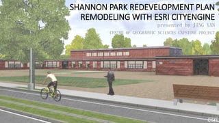
  • 1. SHANNON PARK REDEVELOPMENT PLAN REMODELING WITH ESRI CITYENGINE presented by JING YAN CENTRE OF GEOGRAPHIC SCIENCES CAPSTONE PROJECT
  • 2. Table of Contents  Background  Goals and Objectives  Esri CityEngine Essentials  Project Stages 1. Data Preparation 2. 3D Community Auto-generation Scenarios 3. Redevelopment Plan Remodeling 4. Web Scene Publishing  Discussion (Image Source: www.smarterbettercities.ch)
  • 3. Background  Shannon Park, Dartmouth, NS  42 hectare  Abandoned military community  Ownerships  Significant potentials  2010 Redevelopment Proposal  Urban planning school project  2D and 3D products Shannon Park Dartmouth Shannon Park Boundary (Source: 2015 DigitalGlobe)
  • 4. SketchUp Model 2010 Shannon Park Redevelopment Proposal 2D and 3D Products
  • 5. Goals and Objectives  The project has a two-fold goal: 1) to explore 3D GIS application in urban planning and community design, and 2) to explore Esri CityEngine as a powerful tool of building 3D communities.  To achieve this, the stage-by-stage objectives aim at converting the 2010 redevelopment plan into a realistic 3D model with Esri CityEngine. Top View 2015 Shannon Park CityEngine Model
  • 6. Esri CityEngine Essentials  Dynamic City Layouts  Interactive street networks  Geometries updated on the fly  Grammar-based Modeling  Procedural modeling vs. Hand crafting  Computer Generated Architecture(CGA)  Basic Workflow inside CityEngine Geographical & control maps • Import Street network (centerlines) • Generate • Draw • Import • Edit Lots • Generate • Import • Edit Buildings • Generate • Import • Polygonal Modeling Street Furniture • Generate • Import Final Products • Web Scene Model • Report • Geodatabase CGA Simple Sample
  • 7. Project Stage 1 Data Preparation Data Format Post-processed Product Raster Height Map (DEM) Contours 1m, Spot Heights DWG Georeferenced TIFF Texture ArcGIS Imagery Basemap Raster Georeferenced TIFF Obstacle Map Black and White Imagery Raster Georeferenced TIFF 2D Vector Streets Street Centerlines DWG Line Feature Class Parcels Property Lines DWG Polygon Feature Class Building Footprints Building Polygons DWG Polygon Feature Class Trees Tree Points DWG Point Feature Class Boundary Shannon Park Property Line Feature Class Polygon Feature Class 3D Mesh Buildings Raw Building Models SketchUp File DAE Files Images Facade Photographs, CityEngine Library JPEG, PNG JPEG, PNG Pavement Web Images, CityEngine Library JPEG, PNG JPEG, PNG
  • 9. Project Stage 2 3D Community Auto-generation Scenarios  Levels of Import/Auto-Generation  Import Height Map, Texture, and Obstacle Map  Plus Streets, and Lots  Plus Building footprints  CGA Generated Scenes  International  Sci-fi  Map Layer Usage  With Height Control Map  Without Height Map, Texture, and Obstacle Map (from left to right)
  • 10. CGA Generated Scene - International CGA Generated Scene - Sci-Fi
  • 11. Height Control Example CGA Generated Scene - Schematic Height Map CGA Generated Scene - Schematic SHORE SHORE SHORE
  • 12. Project Stage 3 Redevelopment Plan Remodeling  Work with Streets  Import street centerlines; align to terrain  Edit layer attributes (widths, types, sidewalks, etc.)  Apply CGA rules  Modify streets (nodes, curves, etc.) Import Height Map and Texture Image Work with Streets Work with Lots Work with Buildings Work with Street Texture and Furniture Workflow Streets Colored by Type
  • 13.  Work with Lots  Import lot polygons  Align to terrain and streets  Edit layer attributes (types)  Apply CGA rules Import Height Map and Texture Image Work with Streets Work with Lots Work with Buildings Work with Street Texture and Furniture Workflow Lots with Texture
  • 14.  Work with Buildings  Import building footprint polygons  Edit layer attributes (types and heights)  Apply CGA rules  Polygonal modeling (Shannon Park School, and Townhouses) Import Height Map and Texture Image Work with Streets Work with Lots Work with Buildings Work with Street Texture and Furniture Workflow Buildings by Rules and Modeling
  • 16.  Work with Street Texture and Furniture  Apply CGA rules to each street type  General, Transit, Bikeway, and Walkway  Adjust street attributes based on street types Import Height Map and Texture Image Work with Streets Work with Lots Work with Buildings Work with Street Texture and Furniture Workflow Transit Route Bikeway
  • 17. Project Stage 4 Web Scene Publishing  Three Steps  Prepare scene (bookmarks, cameras, scene light, etc.)  Export to model (groups, layer visibility, metadata, etc.)  Publish to ArcGIS Online  Web Scene User Interface  Map Control  Layer control (turn on/off, swipe)  Search by attributes  Scene settings  Comments and Information
  • 19. Discussion  3D GIS in Urban Planning and Community Design  Software  Autodesk Products, SketchUp, MicroStation  ArcScene, ArcGlobe, ArcGIS Pro  Esri CityEngine  3D City Models  Google Earth landmarks  Toronto 3D Massing open data ►►►  Urban Planning Applications  Zoning  Development proposal in context  Auto-generated reports Toronto in 3D with Height Zoning (Source: www.geoplanit.co.uk/?p=2779)