1. LANDSCAPE ECOLOGY OF THE RED-TAILED HAWK:
WITH APPLICATIONS FOR LAND-USE PLANNING AND EDUCATION
by
William E. Stout
A dissertation submitted in partial fulfillment of
the requirements for the degree of
Doctor of Philosophy
(Land Resources)
at the
UNIVERSITY OF WISCONSIN-MADISON
2004
4. i
For the Birds and Other Wildlife Around Us,
That They May Continue to Enrich Our Lives.
5. ii
LANDSCAPE ECOLOGY OF THE RED-TAILED HAWK:
WITH APPLICATIONS FOR LAND-USE PLANNING AND EDUCATION
Abstract
I used a multi-scale approach to describe land-cover patterns surrounding focal
points (Red-tailed Hawk nests), and to determine which scale or scales are most appropriate
to describe habitat for the species. Based on variations in land-cover composition
surrounding Red-tailed Hawk nests, one to three scales (a 100m-radius circular plot: nest
area; a 250m-radius circular plot: macrohabitat; and a 1000m-radius circular plot:
landscape) adequately describe landscape-scale habitat features.
Red-tailed Hawk reproductive success for this 14-yr study averaged 80.1% nest
success and 1.36 young per active nest. Productivity for 1994 was significantly greater than
other years. Red-tailed Hawk productivity, an index of habitat quality, varied with habitat
composition surrounding nest sites. Wetland area was significantly greater for low
productivity sites, indicating that wetlands are not beneficial for Red-tailed Hawk
productivity. The area of roads and high-density urban habitat were greater for high
productivity sites, and the landscape consisted of smaller habitat patches, indicating that
urban/suburban locations provide high-quality habitat for Red-tailed Hawks. Higher
productivity in high-density urban areas suggests that urban Red-tailed Hawk populations
may be source, not sink, populations. Increased nesting on human-made structures in urban
locations and enhanced reproductive success for these nests reinforce this hypothesis, and
suggest that Red-tailed Hawks are adapting to urban environments.
The Red-tailed Hawk population in southeast Wisconsin is increasing in density and
expanding its range into developed areas as it adapts to the urban environment. It doesn’t
6. iii
appear that the population is approaching limits within the urban study area at this time.
While productivity did not vary significantly with density for this study, the predicted trend
(i.e., reduced productivity at higher densities) exists. Detecting density-dependence may be
difficult because of wide annual variations due to density-independent factors such as
weather. While space, and nest site and prey availability may ultimately be the major
limiting factors for this population, my study suggests that their effects are not yet
detectable in this urban environment.
Suitable Red-tailed Hawk habitat in urban/suburban Milwaukee includes a
significant amount of grassland and other herbaceous cover types (e.g., freeways and
freeway intersections, parks, golf courses, cemeteries). With Red-tailed Hawks nesting on
and hunting from human-made structures in urban areas, the amount of woodland area may
be less important in urban than rural locations. Hunting habitat and wetlands are
consistently present in urban, suburban and rural habitat within 100m of nests, and
therefore, may constitute important habitat components. Consistent Red-tailed Hawk
habitat components (i.e., hunting habitat and wetlands) and nesting habitat (i.e., woodlands)
can be used to measure performance of land-use planning models.
7. iv
ACKNOWLEDGMENTS
Stanley Temple (Beers-Bascom Professor in Conservation, Professor of Wildlife
Ecology and Professor of Environmental Studies, University of Wisconsin - Madison), my
graduate advisor, provided continual support and direction for this project. His guidance
and recommendations along the way provided the framework for quality research in all
aspects: design, analysis and final presentations (e.g., this dissertation). I greatly appreciate
his accepting me as a graduate student.
I greatly appreciate the expertise and time given by my graduate committee
members Scott Craven (Chair, Department of Wildlife Ecology, Extension Wildlife
Specialist and Professor of Wildlife Ecology, University of Wisconsin - Madison), Nancy
Mathews (Associate Professor of Wildlife Ecology and Environmental Studies, University
of Wisconsin - Madison), Lisa Naughton (Assistant Professor of Geography, University of
Wisconsin - Madison) and James Stewart (Professor of Education, University of Wisconsin
- Madison). Certainly, any time that they spent with me and my research project was time
that they could have spent working on their own projects. Nancy Mathews offered
numerous additional and constructive suggestions regarding landscape analyses, and Jim
Stewart provided editorial assistance on the educational unit. John Cary (Senior
Information Processing Consultant, Department of Wildlife Ecology, University of
Wisconsin - Madison) provided invaluable assistance with statistical analyses and
modeling.
Numerous individuals provided assistance with fieldwork and the logistics of my
research for a project that has run for over 15 years. In a very special way, I thank Joe
Papp, wildlife field biologist, friend and colleague, for his continued help with fieldwork
8. v
for over 15 years, and for our thought provoking discussions along the way. Sergej
Postupalsky has graciously allowed me to work as a subpermittee under his master banding
permit issued through the U.S. Geological Survey, Bird Banding Laboratory. Several other
individuals, notably Bill Holton and Diane Visty Hebbert, have given countless hours, days
and months over several years of this study to help with the fieldwork. I also greatly
appreciate the cooperation of the many landowners that have graciously allowed access to
their private lands, in my mind, the ultimate treasure: where Red-tailed Hawks soar, hunt
and nest.
This research has been supported in part by a grant from the U.S. Environmental
Protection Agency (EPA). The grant was a part of EPA’s National Center for
Environmental Research and their Science to Achieve Results (STAR) Graduate Fellowship
Program. Although the research described in this dissertation has been funded in part by
the EPA's STAR program through grant U915758, it has not been subjected to any EPA
review and therefore does not necessarily reflect the views of the Agency, and no official
endorsement should be inferred.
The Zoological Society of Milwaukee provided partial funding through the Wildlife
Conservation Grants for Graduate Student Research program. This funding was secured
with the assistance and collaboration of the Wisconsin Society for Ornithology (WSO). In a
very special way, I thank the deceased Alex Kailing, past WSO Treasurer and new, lost
friend, for all his help with grant writing and application processing for this project and
others.
My Wife, Vicki, daughter, Jennifer, and sons, Tim and Matt provided continual
support, patience and assistance in all areas of this project. I sincerely apologize to my
9. vi
family for being unavailable for Christmas and other family gatherings throughout this
research project, most notably, for the 2003 holiday season; I was writing this dissertation.
10. vii
TABLE OF CONTENTS
DEDICATION......................................................................................................................... i
ABSTRACT............................................................................................................................ ii
ACKNOWLEDGMENTS ..................................................................................................... iv
LIST OF TABLES............................................................................................................... xiii
LIST OF FIGURES ...............................................................................................................xv
LIST OF APPENDICES..................................................................................................... xvii
GENERAL INTRODUCTION................................................................................................1
CHAPTER
I. WHAT IS THE APPROPRIATE SCALE FOR DESCRIBING
HABITAT OF RED-TAILED HAWKS?..............................................................2
Introduction......................................................................................................2
Methods............................................................................................................3
Study Area ...........................................................................................3
Nest Surveys ........................................................................................4
GIS.......................................................................................................4
Statistical Analyses..............................................................................6
Results/Discussion...........................................................................................6
Conclusion .....................................................................................................10
Acknowledgements........................................................................................11
Literature Cited..............................................................................................11
11. viii
II. LANDSCAPE CORRELATES OF REPRODUCTIVE SUCCESS
FOR AN URBAN/SUBURBAN RED-TAILED HAWK
POPULATION. ...................................................................................................23
Introduction....................................................................................................23
Methods..........................................................................................................24
Study Area .........................................................................................24
Nest Surveys ......................................................................................25
Breeding Areas...................................................................................25
Productivity Comparisons and GIS ...................................................27
Statistical Analyses............................................................................28
Results............................................................................................................29
Reproductive Success ........................................................................29
High and Low Productivity................................................................29
Discriminant Function Analysis ........................................................30
Human-Made Nest Structures............................................................31
Discussion......................................................................................................31
Reproductive Success ........................................................................31
High and Low Productivity, and Habitat Quality..............................32
Discriminant Function Analysis ........................................................34
Human-Made Nest Structures............................................................34
Conclusion .....................................................................................................35
Acknowledgements........................................................................................35
Literature Cited..............................................................................................36
12. ix
III. DYNAMICS OF A RED-TAILED HAWK POPULATION IN
AN URBAN ENVIRONMENT. .......................................................................49
Introduction....................................................................................................49
Methods..........................................................................................................50
Study Area .........................................................................................50
Population Surveys ............................................................................51
GIS.....................................................................................................52
Density Correlations and Dispersion Patterns ...................................52
Habitat Expansion..............................................................................53
Statistical Analyses............................................................................53
Results............................................................................................................54
Density...............................................................................................54
Density and Productivity....................................................................55
Density, Percentage of Sites Active and Breeding
Area Re-Use...........................................................................55
Dispersion Patterns ............................................................................56
Habitat Expansion..............................................................................56
Discussion......................................................................................................56
Population Density.............................................................................56
Population Growth.............................................................................57
Density and Productivity....................................................................58
Future Densities .................................................................................59
13. x
Density, Percentage of Sites Active and Breeding
Area Re-Use...........................................................................60
Dispersion Patterns ............................................................................61
Habitat Expansion..............................................................................62
Conclusion .....................................................................................................63
Acknowledgements........................................................................................63
Literature Cited..............................................................................................64
IV. HOW LANDSCAPE FEATURES AFFECT RED-TAILED
HAWK HABITAT SELECTION......................................................................81
Introduction....................................................................................................81
Methods..........................................................................................................82
Study Area .........................................................................................82
Nest Surveys ......................................................................................82
Urban/suburban Habitat and GIS.......................................................83
Habitat Model and Hexagon Predictions...........................................84
Statistical Analyses............................................................................84
Results............................................................................................................85
Urban/suburban Habitat.....................................................................85
Habitat: Use and Non-Use Comparisons...........................................85
Habitat Model and Predictions...........................................................86
Discussion......................................................................................................86
Urban/suburban Habitat.....................................................................86
Habitat: Use and Non-Use Comparisons...........................................87
14. xi
Habitat Model and Predictions...........................................................88
Conclusion .....................................................................................................88
Acknowledgements........................................................................................89
Literature Cited..............................................................................................89
V. CONSISTENT FEATURES OF RED-TAILED HAWK
HABITAT ACROSS RURAL, SUBURBAN AND URBAN
LANDSCAPES....................................................................................................98
Introduction....................................................................................................98
Methods..........................................................................................................99
Study Area .........................................................................................99
Nest Surveys ......................................................................................99
Urban, Suburban and Rural Comparisons, and GIS ........................100
Statistical Analyses..........................................................................102
Results..........................................................................................................102
Discussion....................................................................................................103
Urban, Suburban and Rural Comparisons .......................................103
An Application for Land-Use Planning...........................................105
Conclusion ...................................................................................................107
Acknowledgements......................................................................................107
Literature Cited............................................................................................108
VI. WHERE IN THE CITY ARE RED-TAILED HAWKS? THE
CONCEPTUAL BASIS FOR A GIS EDUCATION UNIT............................119
Introduction..................................................................................................119
15. xii
The GIS Education Unit...............................................................................121
National Science Education Standards ............................................124
Wisconsin Model Academic Standards ...........................................125
ArcView GIS Instructions................................................................126
Acknowledgements......................................................................................133
Literature Cited............................................................................................133
16. xiii
LIST OF TABLES
CHAPTER I
Table 1. Area frequencies for each of the 12 land-cover classes within the
indicated concentric buffers (50m- to 2000m-radius). ..........................................15
Table 2. Perimeter frequencies for each of the 12 land-cover classes within
the indicated concentric buffers (50m- to 2000m-radius)......................................16
Table 3. Patch count frequencies for each of the 12 land-cover classes within
the indicated concentric buffers (50m- to 2000m-radius)......................................17
CHAPTER II
Table 1. Red-tailed Hawk reproductive success over a 14-year period, 1989
through 2002..........................................................................................................40
Table 2. Matrix of pairwise comparisons using the Tukey Multiple
Comparisons Test...................................................................................................41
Table 3. Comparison of habitat surrounding high productivity Red-tailed
Hawk breeding areas (N=24) and low productivity breeding areas
(N=24). Values for area and perimeter are ha and m, respectively. .....................42
Table 4. Summary of stepwise discriminant function analysis for high
productivity and low productivity breeding areas. ................................................44
Table 5. Classification results for the stepwise discriminant function analysis. ..................45
CHAPTER III
Table 1. Red-tailed Hawk population density (minimum estimates) for
occupied sites and active sites in the MMSA and two townships
within this area from 1988 to 2002........................................................................70
Table 2. Dispersion patterns (uniform, random or clumped) for active Red-
tailed Hawk nest sites in the MMSA and two townships within this
area from 1988 to 2002..........................................................................................71
Table 3. Comparison of Red-tailed Hawk habitat cover types for three 5-yr
periods. MPS (Mean Patch Size), PSSD (Patch Size Standard
Deviation), Minimum and Maximum values are in hectare. .................................72
17. xiv
CHAPTER IV
Table 1. Red-tailed Hawk use areas were compared to non-use areas at the
landscape scale (1000-m radius). Land-cover type area (ha),
perimeter (m), patch counts and FRAGSTAT metrics are reported......................93
CHAPTER V
Table 1. Comparison of Red-tailed Hawk habitat for urban, suburban and
rural locations at the landscape scale (1000m-radius buffer). Values
are for percent area...............................................................................................111
Table 2. Comparison of Red-tailed Hawk habitat for urban, suburban and
rural locations at the macrohabitat scale (250m-radius buffer).
Values are for percent area. .................................................................................112
Table 3. Comparison of Red-tailed Hawk habitat for urban, suburban and
rural locations at the nest area scale (100m-radius buffer). Values
are for percent area...............................................................................................113
18. xv
LIST OF FIGURES
CHAPTER I
Figure 1. Southeast Wisconsin Study Area...........................................................................18
Figure 2. Southeast Wisconsin Study Area. The Southeast Wisconsin
Regional Planning Commission (SEWRPC) data set was combined
into the above 12 land-cover classes......................................................................19
Figure 3. Land cover area (%) for 12 classes at varying scales surrounding
Red-tailed Hawk nest sites.....................................................................................20
Figure 4. Land cover perimeter (%) for 12 classes at varying scales
surrounding Red-tailed Hawk nest sites. ...............................................................21
Figure 5. Land cover patch count (%) for 12 classes at varying scales
surrounding Red-tailed Hawk nest sites. ...............................................................22
CHAPTER II
Figure 1. Southeast Wisconsin Study Area showing active (i.e., eggs laid)
Red-tailed Hawk nests from 1989 through 2002...................................................46
Figure 2. Red-tailed Hawk productivity over a 14-year period, 1989 through
2002. ......................................................................................................................47
Figure 3. High and low productivity Red-tailed Hawk breeding areas. ...............................48
CHAPTER III
Figure 1. Metropolitan Milwaukee Study Area. ...................................................................73
Figure 2. Red-tailed Hawk population size for the MMSA..................................................74
Figure 3. Red-tailed Hawk population size for the township of Brookfield.........................75
Figure 4. Red-tailed Hawk population size for the township of Granville...........................76
Figure 5. Red-tailed Hawk breeding density and productivity. ............................................77
Figure 6. Red-tailed Hawk breeding density and percentage of sites active. .......................78
Figure 7. Red-tailed Hawk breeding density and breeding area re-use................................79
19. xvi
Figure 8. Metropolitan Milwaukee Study Area: Urban Red-Tailed Hawk
habitat expansion. The maps include a slightly larger area than the
MMSA. ..................................................................................................................80
CHAPTER IV
Figure 1. Metropolitan Milwaukee Study Area: Red-tailed Hawk use and non-
use areas.................................................................................................................95
Figure 2. Land-cover composition for Red-tailed Hawk use areas and non-use
areas. ......................................................................................................................96
Figure 3. Predictions of the Red-tailed Hawk habitat model................................................97
CHAPTER V
Figure 1. Southeast Wisconsin Study Area (SWSA). The Southeast
Wisconsin Regional Planning Commission (SEWRPC) data set was
combined into the above 12 land-cover classes...................................................114
Figure 2. Landscape-scale buffers (1000-m radius) around urban, suburban
and rural nests in the Southeast Wisconsin Study Area.......................................115
Figure 3. Landscape (1000m buffer area) composition (%) around urban,
suburban and rural Red-tailed Hawk nests in the Southeast
Wisconsin Study Area. ........................................................................................116
Figure 4. Macrohabitat (250m buffer area) composition (%) around urban,
suburban and rural Red-tailed Hawk nests in the Southeast
Wisconsin Study Area. ........................................................................................117
Figure 5. Nest area (100m buffer area) composition (%) around urban,
suburban and rural Red-tailed Hawk nests in the Southeast
Wisconsin Study Area. ........................................................................................118
CHAPTER VI
Figure 1. Map of Red-tailed Hawk Habitat for Milwaukee County. ..................................136
20. xvii
LIST OF APPENDICES
Appendix A. Southeast Wisconsin Regional Planning Commission
(SEWRPC) 1995 Land-use (Land-cover) Codes and
Descriptions and the corresponding land-cover classes for this
project (and the legend color used for project maps and
graphs)..........................................................................................................137
Appendix B. Post hoc test for 10 Buffer Scales, Tukey Multiple
Comparisons - Matrix of pairwise comparison probabilities for
each land-cover type. One-way ANOVA indicated that each
land-cover type (area and perimeter frequencies) is
significantly different over the 10 buffer scales (P<0.001 for
each case).....................................................................................................143
Appendix C. FRAGSTATS Metrics (FRAGSTATS for ArcView, version
1.0) were used to compare habitat of high productivity Red-
tailed Hawk breeding areas to low productivity breeding areas
(Chapter 2), and Red-tailed Hawk use areas to non-use areas
(Chapter 4). FRAGSTATS for ArcView was used to calculate
landscape-scale metrics................................................................................155
Appendix D. Definition, Description and Calculations of CLASS and
LANDSCAPE Metrics, FRAGSTATS Metrics (FRAGSTATS
for ArcView, version 1.0)............................................................................156
21. 1
General Introduction
The wildlife around us continually enrich our lives. My initial exposure to and
fascination with wildlife began as a child as I was raised on our family dairy farm in
Germantown, and included running a trap-line with my brothers and sister each fall. The
experience of releasing a badger from a fox set is certainly an unforgettable one, and
remains a vivid memory. My interest in wildlife continued through young adulthood, and
has led to my passion for and obsession with wildlife research.
In 1987, I started my research on Red-tailed Hawks in the metropolitan Milwaukee
area because the population appeared to be increasing in urban locations. My initial
question was, “are Red-tailed Hawks adapting to the urban environment, occupying suitable
habitat in urban locations that resembles habitat in rural areas, or both?” To accurately
answer this question, I needed to carefully describe the habitat that Red-tailed Hawks were
using. This study quickly became a part of my obsession. Finally, after more than 15 years
of fieldwork, analyzing habitat in multiple ways (e.g., at the nest site, habitat surrounding
the nest site, nest area, macrohabitat and landscape), documenting nest locations and
productivity, and comparing habitat quality based on productivity, I can finally answer a
part of my original question satisfactorily. With 15 years of data, obviously now a long-
term study, I am able to address additional important questions related to Red-tailed Hawk
population dynamics, density and density-dependence. While many questions are not
addressed, answers are within reach through this 15-year data set. This dissertation
provides a good foundation on which additional research questions can be addressed.
22. 2
WHAT IS THE APPROPRIATE SCALE FOR DESCRIBING
HABITAT OF RED-TAILED HAWKS?
Introduction
Habitat has been described at a wide range of scales for different taxa (Wood and
Pullin 2002, Steffan-Dewenter et al. 2002, Mladenoff et al. 1995). Many studies have used
a multi-scale approach to either describe landscape features that characterize habitat
(Griffith et al. 2000, Orth and Kennedy 2001), or explore how species respond to
heterogeneity in the habitats they occupy (Swindle et al. 1999, Kie et al. 2002). Many
recent attempts to standardize raptor habitat descriptions have focused on either 1.0-km or
1.5-km radius circular plots around nest sites or other focal points (B.R. Noon, M.R. Fuller
and J.A. Mosher, unpublished manuscript). Nonetheless, habitats of raptor species have
been described at various landscape scales because of the complex relationships these wide-
ranging predators have with landscape features (Dykstra et al. 2001, Orth and Kennedy
2001). For Red-tailed Hawks (Buteo jamaicensis), the species used for this study, habitat
has been described at several landscape scales ranging from 20ha to 707ha (Howell et al.
1978, Stout et al. 1998).
Although many studies have described habitat at various scales (e.g., Swindle et al.
1999, Fuhlendorf et al. 2002), few have attempted to determine which scales are most
appropriate. Holland et al. (2004) recently developed a method of determining the spatial
scale in which a species responds to habitat. This method may be validated as it is applied
to a wide range of different species. Selection of an appropriate scale is critical, and it
depends on the research question and the taxonomic group or landscape features of interest
(Mitchell et al. 2001, Turner et al. 2001, Mayer and Cameron 2003). Geographic
23. 3
Information Systems (GIS) can help researchers select the appropriate scale for describing
landscape features and comparing landscape features at different scales.
I studied a Red-tailed Hawk population in southeast Wisconsin over a 15-yr period.
My objective was to compare the composition of land-cover types at varying scales around
Red-tailed Hawk nests and to determine the appropriate scale (i.e., spatial extent) for
describing Red-tailed Hawk habitat. I used a multi-scale approach with ten concentric
buffer rings to describe land-cover surrounding Red-tailed Hawk nests. This method of
determining appropriate scale can be applied to other species for which habitat can be
described in circular plots centered on a focal point (e.g., den, nest or perch site).
Methods
Study Area
The study area covers approximately 1600 km2
in the metropolitan Milwaukee area
of southeast Wisconsin (43 N, 88 W), and includes Milwaukee County and parts of
Waukesha, Washington and Ozaukee Counties (Figure 1). Milwaukee and Ozaukee
Counties are bordered by Lake Michigan to the east. Milwaukee County covers an area of
626.5 km2
. Human population density in urban locations (i.e., the city of Milwaukee)
within the study area averages 2399.5/km2
; the city of Milwaukee covers an area of 251.0
km2
with a human population of 596,974 (United States Census Bureau 2000). Landscape
composition ranges from high-density urban use to suburban communities and rural areas.
Population density and human land-use intensity decrease radially from urban to rural.
Two interstate highways (Interstate 43 and Interstate 94) transect the study area. Land
cover within the study area includes agricultural, natural, industrial/commercial, and
residential areas.
24. 4
Curtis (1959) described vegetation, physiography and soil for the study area.
Remnants of historical vegetation that are marginally impacted by development are sparsely
scattered throughout the study area. The size and abundance of these remnants increase
from urban to rural locations (Matthiae and Stearns 1981).
Nest Surveys
Red-tailed Hawk nests were located annually from a vehicle (Craighead and
Craighead 1956) between 1 February and 30 April and visited at least twice (once at an
early stage of incubation within 10 d of clutch initiation, and again near fledging) during
each nesting season to determine Red-tailed Hawk reproductive success (Postupalsky
1974). Woodlots within an intensive study area that were not entirely visible from the road
early in the season before leaf-out were checked by foot.
GIS
For the purposes of analyzing land-cover at varying scales surrounding nest sites, I
used Red-tailed Hawk nest locations for 1988 through 2002. For land-cover, I used the
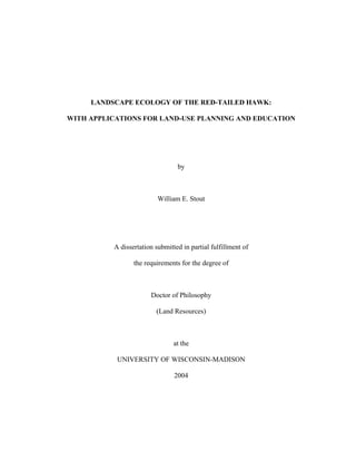
Southeast Wisconsin Regional Planning Commission’s (SEWRPC) 1995 land-cover data
set (SEWRPC 1995). Every five years SEWRPC flies aerial surveys and documents land-
cover through aerial photography. These aerial photos are produced at a 1:4800 scale, and
are digitized into ortho photos as well as a vector GIS land-cover database. The grain of
these ortho photos is less than 0.3m. I used the 1995 SEWRPC data set because it
represents land-cover from approximately the mid-point of the study time frame. SEWRPC
classifies land-cover into 104 different categories (see Appendix A). For the purposes of
this study, I combined the 104 different SEWRPC categories into the following 12 land-
cover classes: urban (high-density), urban (low-density), roads, parking, recreational,
25. 5
graded, cropland, pasture, grassland, woodland, wetland and water (Figure 2). Appendix A
lists each SEWRPC land-cover code and description, the corresponding land-cover class
that I assigned it, and a legend color used in the land-cover map (Figure 2) and graphs
(Figures 3-5). The SEWRPC data set may contain biases because the regional planning
commission is probably more concerned with urban land-cover and its distribution within
cities and suburbs. From an aerial view, a row of houses in one part of a city block looks
the same as another row of adjacent houses within the same city block. However, they are
classified as two different high-density residential patches. Conversely, two adjacent
agricultural fields in a rural area are separated by a distinct hedgerow, yet they are classified
as a single patch. To minimize these potential biases, I merged all adjacent land-cover
patches for each class. ArcView GIS version 3.3 (ESRI 2002) was used for GIS procedures
and analyses.
I used a multi-scale approach (ten concentric buffer rings) to describe and analyze
land-cover patterns surrounding Red-tailed Hawk nest sites. Nest site locations were
mapped in a GIS (Figure 1). I use sites that were at least 2km from the perimeter of the
four-county area to allow for a complete coverage within the SEWRPC land-cover data set
and subsequent analysis. For 1988 through 2000, locations were digitized “on the fly” in a
GIS from knowledge of the actual locations and with the SEWRPC ortho photos and land-
cover data set displayed. For 2001 and 2002, real-time Global Positioning System (GPS)
locations with accuracy of one to three meters were logged using a Trimble GeoExplorer3
and differentially corrected for greater accuracy. These locations were used to verify the
accuracy of 1988-2000 locations. Eight 250m-radius concentric rings were used to buffer
nest sites within a 2000m-radius (250m- to 2000m-radius areas). Two additional areas
26. 6
(50m- and 100m-radius areas) were used for information at smaller scales closer to each
nest site. The boundaries between the buffers were dissolved to maintain independence
(i.e., each land-cover patch is only included once), and the SEWRPC land-cover data were
clipped to fit each buffer. The area, perimeter and patch count for each of the 12 land-cover
classes were determined for each buffer area through GIS procedures. These values were
converted to frequencies (and percentages) for a comparison of the different buffer scales.
Statistical Analyses
A One-way Analysis of Variance (ANOVA) was used to determine whether the area
and perimeter frequencies for each land-cover class were different across buffer scales. For
land-cover area and perimeter frequencies that were different, a post hoc test (Tukey
Multiple Comparisons test) was used to determine which adjacent buffer frequencies were
different.
Results/Discussion
Area, perimeter and patch count frequencies for each of the 12 land-cover classes
within the varying size buffers (50m- to 2000m-radius) are listed in Tables 1-3.
Frequencies were converted to percentages and plotted against the buffer distance from nest
sites (Figures 3 through 5). For each land-cover class, “percent area” is the amount of each
class in relation to the total area for all classes within the buffer area expressed as a percent
(Figure 3). For land-cover area, the percent coverage for each class varies greatly close to
the nest site (e.g., percentages were very different between the 50m- and 100m-radius
buffer areas), and differences decrease as the buffer area increases (e.g., the smallest
differences were between the 1750m- and 2000m-radius buffer areas). The amount of
woodlands and wetlands were the only two classes that increase rapidly at smaller scales,
27. 7
and therefore composed a greater percentage area surrounding the nest. For all other land-
cover classes, the percent composition decreases rapidly at smaller scales. The percent
coverage for three classes, cropland, pasture and grasslands, increases slightly between
250m and 1000m from the nest.
“Percent perimeter” describes the amount of perimeter for each land-cover class in
relation to the total combined perimeters for all classes within the buffer area expressed as a
percentage (Figure 4). The percent perimeter for woodlands and wetlands increases rapidly
at smaller scales around the nest. The percent perimeter for cropland and pasture increases
to 100m then decreases rapidly 50m from nests; grassland percent perimeter increases to
250m then decreases rapidly. These data generally are consistent with the slight rise in
percent area surrounding the nest sites for these three classes. The percent perimeter for
other land-cover classes (high-density urban, low-density urban, roads, parking,
recreational, graded and water) decreases rapidly at smaller scales closer to nest sites.
“Percent patch count” is the number of patches for one land-cover class in relation
to the total number of patches for all classes within the buffer area expressed as a
percentage (Figure 5). The percent patch count for woodlands and wetlands increases
rapidly closer to nest sites, as expected relative to the increases in percent area and
perimeter. Conversely, the percent patch count for four land-cover classes (high-density
urban, low-density urban, parking and graded) decreases at smaller scales closer to nest
sites. The percent patch count for grasslands, water and recreational land remains relatively
constant from 2000m to 250m, peak at the 100m-radius scale, followed by a decline at the
50m-radius scale. Percent patch count for cropland and pasture increase rapidly closer to
28. 8
the nests and then appear to level off. Percent patch count for the road class increases from
the 2000m-radius scale to the 250m-radius scale, and decreases to the 50m-radius scale.
The increase in the percent composition of woodlands (area, perimeter and patch
count) within the buffer areas closer to nest sites is expected since Red-tailed Hawks
typically nest in trees associated with woodlots, at least in southeast Wisconsin. On the
other hand, an increase in the amount of wetlands surrounding nest sites is not necessarily
expected. When comparing landscape composition at Red-tailed Hawk nest sites with high
and low productivity, wetland area was the only land-cover class that was significantly
greater for low productivity sites, indicating that wetlands are not beneficial for
reproduction (Stout, 2004). However, wetlands may provide a natural type of buffer
between human activity and Red-tailed Hawk nesting activity. Because of the sensitive
nature of wetlands and a number of benefits that they provide humans, the land-use
planning process tends to preserve these areas. The slight rise in percent composition of
cropland, pasture and grasslands near nests (i.e., between 250 and 1000m of nest sites) may
be related to suitable hunting habitat in the surrounding area and within a reasonable
hunting distance of the nests (i.e., within their home range of approximately 150 to 250ha).
Based on these variations in land-cover composition at increasing distances from
nest sites, I suggest that one to three different scales should be adequate to describe
landscape-scale features and to address most research questions. When a multi-scale
approach is required for a specific research question, a preliminary analysis can plot gradual
land-cover changes as the area for analysis increases. Land cover features plotted against
varying buffer areas (i.e., different scales) can be used to determine appropriate scales for
further analysis. Based on Figures 3 through 5, one to three areas are sufficient to describe
29. 9
landscape features. For Red-tailed Hawk nest sites, a 100m-radius circular plot (3.1ha) is
an appropriate scale to describe habitat at a “nest area” scale. At this nest area scale, the
variations in landscape composition are greatest for most land-cover classes (e.g.,
approaching vertical asymptote; Figures 3-5). A 250m-radius circular plot (19.6ha) is
appropriate to describe habitat at a “macrohabitat” scale because the variations in
composition for most land-cover classes are shifting at this point (e.g., closest to the
hyperbolic focus). A 1000m-radius circular plot (314.2ha) is appropriate to describe habitat
at a “landscape” scale because the variations in composition for most land-cover classes are
smallest at this point (e.g., approaching horizontal asymptote). These areas can be used in
conjunction with nest site (nest height, tree species, etc.) and habitat (vegetative cover
surrounding the nest, frequently an 11.3m-radius circular plot) data collected at the nest.
Holland et al. (2004) recently presented a method to determine the scale in which species’
respond to habitat. This method may be validated as it is applied to a wide range of
different taxa. However, this paper presents a similar, additional method to determine the
appropriate scale or scales for landscape analysis of habitat. This multi-scale approach used
as a preliminary analysis can identify the important scales or extents for any focal point
(e.g., den, nest or perch site) associated with any taxonomic group. This method can aid in
determining which scale or scales will be useful in addressing the research problem.
Each land-cover class was significantly different for both area and perimeter
frequencies across the ten buffer scales (One-way ANOVA: P<0.001 for every case). For
pairwise comparisons (Tukey Multiple Comparisons test, Appendix B), at smaller buffer
scales around nests (i.e., 50m, 100m, 250m), frequencies for both area and perimeter were
usually significantly different. Infrequently (i.e., 4 out of 72 pairwise comparisons), area
30. 10
frequencies were not significantly different. Consistently for area and perimeter of each
land-cover class, a buffer scale was reached in which all subsequent adjacent frequencies
were not significantly different (Tables 1 and 2). I used this characteristic of adjacent
frequencies to aid in determining an appropriate scale for landscape analysis. The 1000-m
buffer consistently accounts for differences in area and perimeter frequencies, and therefore
is an appropriate scale for Red-tailed Hawk habitat analyses.
Land cover area, perimeter and patch count all indicate that a 1000m-radius area
(314.2ha) surrounding Red-tailed Hawk nest sites is an appropriate scale for landscape
analysis of habitat. While variations and fluctuations exist at smaller scales, land-cover
area, perimeter and patch count metrics (i.e., percent composition) generally level off
1000m from the nest site. Analysis of area and perimeter frequencies for differences across
the varying buffer scales supports this conclusion. I will use this scale (1000m-radius area)
for subsequent Red-tailed Hawk habitat descriptions and comparisons (e.g., nesting habitat
and non-use areas, high and low productivity habitat).
Conclusion
A detailed description of a species’ habitat can help explain relationships between
the species and its environment, and it can be used for management and conservation
purposes. Using the appropriate scale or scales to describe habitat is critical. I used a
multi-scale approach (ten concentric buffer rings) to describe land-cover patterns
surrounding focal points (Red-tailed Hawk nests), and to determine which scale or scales
are most appropriate to describe the habitat for the species.
Based on the variations in land-cover composition at increasing distances from Red-
tailed Hawk nest sites, one to three different scales should be adequate to describe
31. 11
landscape-scale features and to address most research questions. For Red-tailed Hawks, a
100m-radius circular plot is an appropriate scale to describe the nest area, a 250m-radius
circular plot is appropriate for macrohabitat, and a 1000m-radius circular plot is appropriate
for landscape.
This multi-scale approach can be used to determine the most appropriate scale or
scales for describing the habitat associated with any taxonomic group at any focal point
(e.g., den, nest or perch site).
Acknowledgements
I thank S.A. Temple, S.R. Craven, N.E. Mathews, L. Naughton and J.H. Stewart for
providing valuable comments that greatly improved this manuscript. J.R. Cary provided
technical assistance. J.M. Papp and W. Holton provided field assistance. This research has
been supported in part by a grant from the U.S. Environmental Protection Agency's Science
to Achieve Results (STAR) program. Although the research described in this article has
been funded in part by the U.S. Environmental Protection Agency's STAR program through
grant U915758, it has not been subjected to any EPA review and therefore does not
necessarily reflect the views of the Agency, and no official endorsement should be inferred.
The Zoological Society of Milwaukee provided partial funding through the Wildlife
Conservation Grants for Graduate Student Research program. My family provided
continual support, patience and assistance in all areas of this project.
Literature Cited
Craighead, J.J. and F.C. Craighead. 1956. Hawks, owls and wildlife. The Stackpole Co.,
Harrisburg, and Wildlife Management Institute, Washington, D.C. USA. 443 p.
32. 12
Curtis, J.T. 1959. The Vegetation of Wisconsin: An Ordination of Plant Communities.
University of Wisconsin Press, Madison, Wisconsin USA. 657 p.
Dykstra, C.R., F.B. Daniel, J.L. Hays and M.M. Simon. 2001. Correlation of Red-
shouldered Hawk abundance and macrohabitat characteristics in southern Ohio.
Condor 103:652.
ESRI. 2002. ArcView GIS version 3.3. Environmental Systems Research Institute
(ESRI), Inc. Redlands, California USA.
Fuhlendorf, S.D., A.J.W. Woodward, D.M. Leslie and J.S. Shackford. 2002. Multi-scale
effects of habitat loss and fragmentation on lesser prairie-chicken populations of the
US Southern Great Plains. Landscape Ecology 17:617-628.
Griffith, J.A., E.A. Martinko and K.P. Price. 2000. Landscape structure analysis of Kansas
at three scales. Landscape and Urban Planning 52:45-61.
Holland, J.D., D.G. Bert and L. Fahrig. 2004. Determining the spatial scale of species’
response to habitat. Bioscience 227-233.
Howell, J., B. Smith, J.B. Holt and D.R. Osborne. 1978. Habitat structure and productivity
in the Red-tailed Hawk. Bird Banding 49:162-171.
Kie, J.G., R.T. Bowyer, M.C. Nicholson, B.B. Boroski and E.R. Loft. 2002. Landscape
heterogeneity at differing scales: Effects on spatial distribution of mule deer.
Ecology 83:530-544.
Matthiae, P.E., and F. Stearns. 1981. Mammals in forest islands in southeastern
Wisconsin. Pages 55-66 in R.L. Burgess and D.M. Sharpe, eds. Forest island
dynamics in man-dominated landscapes. Spring-Verlag, New York.
33. 13
Mayer, A.L. and G.N. Cameron. 2003. Consideration of grain and extent in landscape
studies of terrestrial vertebrate ecology. Landscape and Urban Planning 65:201-
217.
Mitchell, M.S., R.A. Lancia and J.A. Gerwin. 2001. Using landscape-level data to predict
the distribution of birds on a managed forest: effects of scale. Ecological
Applications 11:1692-1708.
Mladenoff, D.J., T.A. Sickley, R.G. Haight and A.P. Wydeven. 1995. A Regional
Landscape Analysis and Prediction of Favorable Gray Wolf Habitat in the Northern
Great Lakes Region. Conservation Biology 9:279-294.
Orth, P.B., and P.L. Kennedy. 2001. Do land-use patterns influence nest-site selection by
Burrowing Owls (Athene cunicularia hypugaea) in northeastern Colorado?
Canadian Journal of Zoology 79:1038-1045.
Postupalsky, S. 1974. Raptor reproductive success: some problems with methods, criteria,
and terminology. Pages 21-31 in F.N. Hamerstrom, B.E. Harrell and R.R.
Olendorff, eds. Management of raptors. Raptor Research Report No. 2. Proceedings
of the conference on raptor conservation techniques. Fort Collins, Colorado USA.
SEWRPC. 1995. Southeast Wisconsin Regional Planning Commission (SEWRPC) 1995
land-use data. Waukesha, Wisconsin USA.
Steffan-Dewenter, I., U. Muenzenberg, C. Buerger, C. Thies and T. Tscharntke. 2002.
Scale-dependent effects of landscape context on three pollinator guilds. Ecology
83:1421-1432.
34. 14
Stout, W.E. 2004. Landscape ecology of the Red-tailed Hawk: with applications for land-
use planning and education. Ph.D. Dissertation, University of Wisconsin, Madison,
Wisconsin USA.
Stout, W.E., R.K. Anderson and J.M. Papp. 1998. Urban, suburban and rural Red-tailed
Hawk nesting habitat and populations in southeast Wisconsin. Journal of Raptor
Research 32:221-228.
Swindle, K.A., W.J. Ripple, E.C. Meslow and D. Schafer. 1999. Old-forest distribution
around Spotted Owl nests in the central Cascade Mountains, Oregon. Journal of
Wildlife Management 63:1212-1221.
Turner, M.G., R.H. Gardner and R.V. O'Neill. 2001. Landscape ecology in theory and
practice: pattern and process. Springer Verlag, New York, NY USA.
United States Census Bureau. 2000. United States Census 2000. United States
Department of Commerce. Located at:
http://www.census.gov/main/www/cen2000.html.
Wood, B.C. and A.S. Pullin. 2002. Persistence of species in a fragmented urban landscape:
the importance of dispersal ability and habitat availability for grassland butterflies.
Biodiversity and Conservation 11:1451-1468.
39. 19
Milwaukee Co.
Ozaukee Co.
Washington Co.
Waukesha Co.
Lake
Michigan
10 0 10 20 Kilometers
N
Southeast Wisconsin
Study Area
Urban (high density)
Urban (low density)
Roads
Parking
Recreational
Graded
Cropland
Pasture
Grassland
Woodland
Wetland
Water
Land Cover Classes
Figure 2. Southeast Wisconsin Study Area. The Southeast Wisconsin
Regional Planning Commission (SEWRPC) data set was combined
into the above 12 land-cover classes.
43. 23
LANDSCAPE CORRELATES OF REPRODUCTIVE SUCCESS FOR AN
URBAN/SUBURBAN RED-TAILED HAWK POPULATION
Introduction
Reproductive success can be used as a measure of fitness of individuals and an
index for habitat quality. Changes in reproductive success can indicate changes in
environmental factors such as resource availability, human disturbance, competition,
weather or the presence of chemical contaminants in the environment (Preston and Beane
1993, Newton 1998). Reproductive success for Red-tailed Hawks (Buteo jamaicensis) has
been well studied throughout its range (Preston and Beane 1993). While long-term studies
have documented Red-tailed Hawk reproductive success, including several studies in rural
Wisconsin (Orians and Kuhlman 1956, Gates 1972, Petersen 1979), only a few focus on
urban or suburban populations (Minor et al. 1993, Stout et al. 1998). The paucity of
information on these expanding urban raptor populations warrants continued studies
(Cringan and Horak 1989).
Habitat selection theory predicts that individuals will prefer high-quality habitats
over low-quality habitats (Fretwell and Lucas 1970). Habitat quality can affect population
parameters such as density and reproductive success (Newton 1998). Reproductive success
can be used as an index of habitat quality and has been correlated with several
environmental factors that affect habitat quality. For Red-tailed Hawks, these factors
include availability of prey and perch sites for hunting (e.g., Janes 1984), and composition
of habitat cover (e.g., Howell et al. 1978). While studies have focused on the impacts of
these factors on the habitat quality of rural populations, they may not adequately describe
the effects on urban/suburban populations. A clearer understanding of habitat quality in
44. 24
urban/suburban locations will provide insight into overall habitat quality for Red-tailed
Hawks across all landscape types.
I studied an urban/suburban Red-tailed Hawk population in southeast Wisconsin
over a 14-year period. The objectives of this study were to document long-term
reproductive success for this population, and to determine the characteristics of high-quality
Red-tailed Hawk habitat by comparing habitat structure and composition surrounding nests
exhibiting high and low reproductive success. I also document Red-tailed Hawks nesting
on human-made structures during this study and compare productivity of these nests to
nests built in trees.
Methods
Study Area
The study area is located in southeast Wisconsin, and includes Milwaukee County
(43 N, 88 W) and parts of Waukesha, Washington, Ozaukee and Dodge Counties (Figure
1). Milwaukee and Ozaukee Counties are bordered by Lake Michigan to the east.
Milwaukee County covers an area of 626.5 km2
. Human population density in urban
locations (i.e., the city of Milwaukee) within the study area averages 2399.5/km2
; the city of
Milwaukee covers an area of 251.0 km2
with a human population of 596,974 (United States
Census Bureau 2000). Landscape composition ranges from high-density urban use to
suburban communities and rural areas. Population density and human land-use intensity
decrease radially from urban to rural. Two interstate highways (Interstate 43 and Interstate
94) transect the study area. Land cover within the study area includes agricultural, natural,
industrial/commercial, and residential areas.
45. 25
Curtis (1959) described vegetation, physiography and soil for the study area.
Remnants of historical vegetation that are marginally impacted by development are sparsely
scattered throughout the study area. The size and abundance of these remnants increase
from urban to rural locations (Matthiae and Stearns 1981).
Nest Surveys
Red-tailed Hawk nests were located annually from a vehicle (Craighead and
Craighead 1956) between 1 February and 30 April and visited at least twice (once at an
early stage of incubation within 10 d of clutch initiation, and again at or near fledging)
during each nesting season to determine Red-tailed Hawk reproductive success
(Postupalsky 1974). Nest locations found throughout the study area are included in
reproductive success. An active nest is a nest in which eggs were laid and constitutes a
nesting attempt (Postupalsky 1974). Productivity is based on the number of young that are
≥ 15 days old (range: 15-40d). Consistent nest searching efforts were made within a survey
area (Figure 3). Woodlots within an intensive study area that were not entirely visible from
the road early in the season before leaf-out were checked by foot. Nest substrate (i.e., tree
species or structure type) was recorded.
Breeding Areas
Red-tailed Hawk home ranges are relatively large, and nests that are used in
different years by a mated pair can be widely spaced within this area. The home ranges for
adjacent pairs commonly overlap, making if difficult to determine which nest structures are
a part of which individual breeding area. A “breeding area” is an area that contains one or
more nests within the home range of a pair of mated birds (Postupalsky 1974, Steenhof
1987). I used a multi-scale approach in a Geographic Information System (GIS) to
46. 26
determine which active nests belong within a single breeding area over the 14-yr study
(1989-2002). I used the following procedures and guidelines to determine which nests are
included within a breeding area.
1) Ten concentric buffer rings (50m- to 500m-radius buffers in 50m increments) were
used to link individual Red-tailed Hawk nests incrementally. For example, two
nests that are active in different years and within 100m of each other are linked by
the 50m-radius buffer. These two nests are more likely to be in the same breeding
area than two nests that are 500m apart (and active in different years).
2) The 350m-radius buffer area (i.e., nests that were 700m apart or less) was used as
the initial buffer to link the nest locations into “nest clusters” (i.e., nests within the
350m-radius buffer area).
3) Nests within a nest cluster that were active during the same year were separated into
different breeding areas.
4) The nest closest to the nest structure from the previous year was included in the
breeding area. In some cases, one nest cluster included two breeding areas. That is,
two mated pairs of Red-tailed Hawks consistently nested within 700m of each other
over the 14-yr period. Frequently, one nest was used in multiple years (i.e.,
appeared to be a favorite nest).
5) Nests in larger buffer areas (i.e., 400m-radius, then 450m-radius, etc.) were included
in a breeding area if it was not in a different breeding area and was active in a year
that was not already accounted for in that breeding area.
6) A breeding area was not necessarily active every year.
47. 27
7) A minimum breeding area was calculated using the minimum convex polygon
(MCP) method. For breeding areas that included only two nest structures, I used a
1m buffer around a straight line connecting the two nests to calculate breeding area.
Breeding areas rarely overlapped and infrequently a nest structure was used by
different breeding pairs in different years.
Productivity Comparisons and GIS
Only breeding areas that were active for five or more years over the 14-yr study
period were examined for productivity. A nest site was considered to have high
productivity if it averaged ≥ 1.67 young per nesting attempt, and low productivity if it
averaged ≤ 1.00 young per nesting attempt. Nest sites with productivity between 1.00 and
1.67 were not included in the productivity comparison. These values were used to obtain
an appropriate and equal sample size without jeopardizing the validity of the productivity
comparison.
Red-tailed Hawk habitat was compared for 24 high and 24 low productivity
breeding areas within a 1000m-radius buffer area (314.2ha; Stout 2004) around the center
(arithmetic mean of nest site locations) of each breeding area (Figure 3). Overlap of the
buffer areas (i.e., two areas with high productivity, areas with high and low productivity, or
two areas with low productivity) and, therefore, pseudoreplication was allowed for this
comparison since the overlapping areas may contain important habitat components that
affect breeding area productivity.
To describe and compare Red-tailed Hawk habitat within the 1000m-radius buffer
areas, I used the Southeast Wisconsin Regional Planning Commission’s (SEWRPC) 1995
land-cover data set (SEWRPC 1995) and combined 104 different SEWRPC categories into
48. 28
the following 12 land-cover classes: urban (high-density), urban (low-density), roads,
parking, recreational, graded, cropland, pasture, grassland, woodland, wetland and water.
See Stout (2004) for a description of the SEWRPC data set, which SEWRPC categories are
included in each of the above 12 land-cover types, and methods used to enter Red-tailed
Hawk nest locations into a GIS. ArcView GIS version 3.3 (ESRI 2002) was used for GIS
procedures and analyses. Area, perimeter and patch count (FRAGSTSTATS metrics) were
compared for each of the 12 land-cover classes (Table 3). Eighteen additional
FRAGSTATS landscape metrics (Appendix C and D) and breeding area size (MCP for
nests) were compared (Table 3). FRAGSTATS for ArcView version 1.0 (Space Imaging
2000) was used to calculate the additional 18 FRAGSTATS metrics.
Statistical Analyses
For statistical analyses, parametric methods were used for comparing productivity
across years and habitat around high and low productivity nests, and non-parametric
methods were used to compare productivity of nests on human-made structures to nests in
trees. A One-way Analysis of Variance (ANOVA) was used to compare Red-tailed Hawk
productivity across years. A post hoc test (Tukey Multiple Comparisons test) was used to
identify differences in productivity between years. A two-sample t-test (Snedecor and
Cochran 1989) was used to compare habitat surrounding high and low productivity Red-
tailed Hawk breeding areas. A Mann-Whitney U test (Chi-square approximation: Sokal
and Rohlf 1981) was used to compare productivity of nests built on human-made structures
to nests in trees. Non-parametric analysis was used to compare productivity of nests on
structures to those in trees because of the disparity in sample size and small range (0-3).
49. 29
All uni-variate tests were considered significant when P 0.05. SYSTAT (SPSS 2000)
was used for these statistical analyses.
Multi-variate analysis (stepwise discriminant function analysis) was used to
distinguish between high productivity and low productivity nest sites, and thus, to identify
variables that differentiate between high-quality and low-quality habitat. To determine
which habitat variables to include in the discriminant function analysis, a two-sample t-test
was used to identify variable means significantly different at P ≤ 0.10. A Pearson
correlation analysis was used to eliminate highly correlated variables (r ≥ 0.7). Variables
different at P ≤ 0.10 that were not highly correlated were entered into the stepwise
discriminant function analysis. Rao's V was used as the selection criteria for the stepwise
procedure. The Statistical Package for the Social Sciences (SPSS version 12.0, Nie et al.
1975, SPSS 2003) was used for the multi-variate analysis.
Results
Reproductive Success
I observed 1136 Red-tailed Hawk nesting attempts (55 to 101 nesting attempts
annually) from 1989 to 2002. Red-tailed Hawk nest success averaged 80.1%, with 1.36
young per active nest and 1.70 young per successful nest (Table 1). Productivity for active
nests (Figure 2) varied significantly over the 14-yr study (One-way ANOVA: F=2.774,
df=13, P=0.001). A Tukey Multiple Comparisons test showed that productivity for 1994
was significantly higher than all other years except 1992 (Table 2).
High and Low Productivity
Red-tailed Hawk productivity averaged 1.85 young per nesting attempt (range: 1.67-
2.40) for the 24 high productivity breeding areas compared to 0.83 young per nesting
50. 30
attempt (range: 0.14-1.00) for low productivity breeding areas. High productivity breeding
areas were active more often and produced more total young than low productivity breeding
areas (Table 3). Four high productivity areas, active for a combined 52 years (one of which
was active for 14 consecutive years), produced a total of 87 young. Conversely, four low
productivity areas, active for a combined 42 years, only produced 28 young. Although
breeding areas with multiple nests (i.e., > 2 nests) were larger than breeding areas with two
nests, size of breeding area was not different for high and low productivity sites (Table 3).
In a comparison of habitat surrounding the 24 high and 24 low productivity Red-
tailed Hawk breeding areas (1000m-radius buffer area), six of 54 FRAGSTATS metrics for
habitat features were significantly different (Table 3). High-density urban area, perimeter
and patch count, and road area were greater for high productivity sites compared to low
productivity sites. Wetland area was less and mean patch size (FRAGSTATS metric MPS)
was smaller for high productivity sites compared to low productivity sites.
Discriminant Function Analysis
Twelve of 54 habitat variables were significantly different at P ≤ 0.10 (Table 3), and
seven of these 12 variables were not highly correlated (r ≤ 0.7). These seven variables were
entered into a stepwise discriminant function analysis. The discriminant analysis selected
two variables, road area and mean patch fractal dimension (MPFD, FRAGSTATS metric),
for inclusion in one canonical discriminant function (Table 4). Based on these two
variables, the discriminant function correctly re-classified 75.0% of 48 nest sites (Table 5).
The discriminant function was weighted slightly more on road area compared to mean
patch fractal dimension (MPFD).
Human-Made Nest Structures
51. 31
Stout et al. (1996) documented 15 successful Red-tailed Hawk nests on five human-
made structures in five separate breeding areas in southeast Wisconsin over a 4-yr period.
For this study, Red-tailed Hawks continued to nest on these human-made structures, and
they nested on 11 additional structures. Red-tailed Hawks made 65 nesting attempts on 16
different human-made structures in 13 different breeding areas over the 15-yr study
(includes data from Stout et al. 1996). Fifty-eight (90.6%) of 64 nesting attempts were
successful, and 101 young were raised in 61 nests (1.66 young per active nest). I was
unable to determine success for one nest and productivity for four nests because access was
denied by landowners. Nest structures included six different high-voltage transmission
towers (35 nesting attempts), four billboards (15), two civil defense sirens (6), the outfield
lights of a professional baseball team ballpark (3), a building fire-escape platform (3), a 76-
m high cell phone tower (2), and a water tower (1). Productivity was significantly greater
for nests on human-made structures (mean ± SE, range: 1.66 ± 0.11, 0-3, N=61) compared
to nests built in trees (1.33 ± 0.03, 0-3, N=1074; Mann-Whitney U test: χ2
=6.725, P=0.010).
Discussion
Reproductive Success
Measures of Red-tailed Hawk reproductive success for this study are consistent with
other studies throughout North America. Nest success for this study averaged 80.1% over
the 14-yr period compared to an 83% average nest success reported by Mader (1982) for
several combined studies (typical range: 58%, Hagar 1957 to 93%, Mader 1978). For other
studies in Wisconsin, nest success averaged 73.6% (range: 63.6% to 88.9%) for Orians and
Kuhlman (1956) and 64.5% (range: 50.0% to 77.8%) for Gates (1972), each over a 3-yr
period. Productivity for this study averaged 1.36 young per active nest compared to 1.43
52. 32
(range: 1.09 to 1.78) for Orians and Kuhlman (1956) and 1.13 (range: 0.92 to 1.44) for
Gates (1972). In a comparable urban/suburban study in central New York, Minor et al.
(1993) reported an average productivity of 1.10 young per active nest over a 10-yr period.
Red-tailed Hawk productivity varies annually with prey abundance and availability,
and weather. Furthermore, weather is correlated with the abundance of many species
commonly associated with the Red-tailed Hawk prey base (e.g., Microtus spp.).
Productivity for 1994 was significantly higher than all other years over the 14-yr period
except 1992. While weather during 1994 was unremarkable, the lack of adverse weather
conditions may have positively affected prey populations, and consequently, Red-tailed
Hawk productivity. However, in 1996 and 1997, the absence of any Red-tailed Hawk nests
with three young was probably due to inclement weather conditions. I noted unusually cold
spring seasons for both of these years, and leaf-out was unusually late. The cold spring air
temperatures for these two years were probably responsible for minimal leaf growth on
trees into mid-May. Weather records for the Milwaukee area confirm these weather
conditions (i.e., heavy snows during mid-March and record-cold spring temperatures; NWS
2003, SCO 2003).
High and Low Productivity, and Habitat Quality
Red-tailed Hawk productivity is associated with habitat quality surrounding nest
sites. Janes (1984) studied Red-tailed Hawks in Oregon and found that reproductive
success correlated with dispersion and density of perch sites used for hunting, as well as
prey availability, suggesting that prey availability is more important to reproductive success
than abundance; and therefore, an increase in prey availability improves habitat quality.
Howell et al. (1978) studied a rural population in Ohio and correlated reproductive success
53. 33
with habitat features. Productivity was associated with the amount of fallow land, cropland
and woodlots surrounding the nest site. High productivity sites had more than twice as
much fallow land, less than half as much cropland, and less than half the number of
woodlots compared to low productivity sites. Howell et al.’s (1978) study also suggests
that hunting habitat (i.e., fallow land) may be important for habitat quality.
For this study, wetland area is the only habitat type that was significantly greater for
low productivity sites, indicating that wetlands are not beneficial for Red-tailed Hawk
reproductive success and, therefore, may provide low-quality habitat. However, wetlands
may also provide a natural buffer between human activity and Red-tailed Hawk nesting
activity. Because of the sensitive nature of wetlands and a number of benefits that they
provide, they tend to be preserved as other areas are developed.
High-density urban habitat composition (area, perimeter and patch counts) and the
area of roads were greater for high productivity sites, and the landscape consisted of smaller
habitat patches (i.e., mean patch size). This indicates that urban locations provide high-
quality habitat for Red-tailed Hawks. Higher productivity in high-density urban areas
suggests that urban Red-tailed Hawk populations may be source, not sink, populations.
Additional data on local recruitment rates are necessary to support this hypothesis (Pulliam
1988). A positive recruitment rate for this study area would indicate that the urban
population is a source population. Smaller mean patch size, a characteristic of urbanization,
for high productivity sites is further evidence that urban areas are beneficial for Red-tailed
Hawk reproduction.
Discriminant Function Analysis
54. 34
The discriminant function analysis combined one habitat feature, road area, and one
habitat characteristic, mean patch fractal dimension, into a single discriminant function to
explain habitat quality with 75% accuracy. The importance of road area in the discriminant
function combined with the greater area of roads surrounding high productivity sites
reinforces the hypothesis that urban/suburban areas provide high-quality habitat. Roads, in
particular freeways and the grassy areas associated with them, may provide high-quality
hunting habitat. The emergence of mean patch fractal dimension as a useful habitat
characteristic provides a new aspect to high-quality habitat. High-quality habitat (i.e., high
productivity sites) has patches that are, on average, less convoluted than low-quality
habitat. A lower mean patch fractal dimension may be consistent with a smaller mean
patch size (MPS), another characteristic of high-quality habitat and a characteristic of
urbanization.
Human-Made Nest Structures
Stout et al. (1996) documented Red-tailed Hawks nesting on five different human-
made structures, and compared nest site characteristics and habitat for these structures to
nests on natural structures. For this study, Red-tailed Hawks continued to consistently nest
on these human-made structures, and nested on 11 additional structures. Nesting success
and productivity for nests on human-made structures are higher than for nests in trees,
suggesting that nesting on human-made structures is beneficial for reproductive success.
These locations may provide protection from some types of natural nest predators (e.g.,
Great Horned Owls and raccoons; Bubo virginianus, Procyon lotor, respectively) because
they tend to be higher (Stout et al. 1996) and on steel structures that are more difficult for
mammalian predators to climb. Landscape features surrounding these structures may also
55. 35
provide quality habitat and contribute to improved reproductive success and fitness.
Increased use of human-made structures in urban locations during this study suggests that
Red-tailed Hawks are adapting to urban environments.
Conclusion
Red-tailed Hawk reproductive success for this 14-yr study is consistent with other
studies across North America, averaging 80.1% nest success and 1.36 young per active
nest. Productivity for 1994 was significantly greater than other years.
Red-tailed Hawk productivity, an index of habitat quality, varied with habitat
composition surrounding nest sites. Wetland area was the only habitat type that was
significantly greater for low productivity sites, indicating that wetlands are not beneficial
for Red-tailed Hawk productivity. The area of roads and high-density urban habitat were
greater for high productivity sites, and the landscape consisted of smaller habitat patches.
This indicates that urban/suburban locations provide high-quality habitat for Red-tailed
Hawks. Higher productivity in high-density urban areas suggests that urban Red-tailed
Hawk populations may be source, not sink, populations. Increased nesting on human-made
structures in urban locations and enhanced reproductive success for these nests reinforce
this hypothesis, and suggests that Red-tailed Hawks are adapting to urban environments.
Acknowledgements
I thank S.A. Temple, S.R. Craven, N.E. Mathews, L. Naughton and J.H. Stewart for
providing valuable comments that greatly improved this manuscript. J.R. Cary provided
technical assistance. J.M. Papp and W. Holton provided field assistance. This research has
been supported in part by a grant from the U.S. Environmental Protection Agency's Science
to Achieve Results (STAR) program. Although the research described in this article has
56. 36
been funded in part by the U.S. Environmental Protection Agency's STAR program through
grant U915758, it has not been subjected to any EPA review and therefore does not
necessarily reflect the views of the Agency, and no official endorsement should be inferred.
The Zoological Society of Milwaukee provided partial funding through the Wildlife
Conservation Grants for Graduate Student Research program. My family provided
continual support, patience and assistance in all areas of this project.
Literature Cited
Cottrell, M.J. 1981. Resource partitioning and reproductive success of three species of
hawks (Buteo spp.) in an Oregon prairie. M.Sc. Thesis, Oregon State University,
Corvallis, Oregon USA. 72pp.
Craighead, J.J. and F.C. Craighead. 1956. Hawks, owls and wildlife. The Stackpole Co.,
Harrisburg, and Wildlife Management Institute, Washington, D.C. USA. 443 p.
Curtis, J.T. 1959. The Vegetation of Wisconsin: An Ordination of Plant Communities.
University of Wisconsin Press, Madison, Wisconsin USA. 657 p.
ESRI. 2002. ArcView GIS version 3.3. Environmental Systems Research Institute
(ESRI), Inc. Redlands, California USA.
Fretwell, S.D., and H.L. Lucas. 1970. On territorial behavior and other factors influencing
habitat distribution in birds. Acta Biotheoretica 19:16-36.
Gates, J.M. 1972. Red-tailed Hawk populations and ecology in east-central Wisconsin.
Wilson Bulletin 84:421-433.
Hagar, D.C., Jr. 1957. Nesting populations of Red-tailed Hawks and Horned Owls in
central New York State. Wilson Bulletin 69:263-272.
57. 37
Howell, J., B. Smith, J.B. Holt, Jr. and D.R. Osborne. 1978. Habitat structure and
productivity in Red-tailed Hawks. Bird Banding 49:162-171.
Janes, S.W. 1984. Influences of territory composition and interspecific competition on
Red-tailed Hawk reproductive success. Ecology 65:862-870.
Mader, W.J. 1978. A comparative nesting study of Red-tailed Hawks and Harris Hawks in
southern Arizona. Auk 95:327-337.
Mader, W.J. 1982. Ecology and breeding habits of the Savanna Hawk in the Llanos of
Venezuela. Condor 84:261-271.
Matthiae, P.E., and F. Stearns. 1981. Mammals in forest islands in southeastern
Wisconsin. Pages 55-66 in R.L. Burgess and D.M. Sharpe, eds. Forest island
dynamics in man-dominated landscapes. Spring-Verlag, New York, NY USA.
Minor, W.F., M. Minor and M.F. Ingraldi. 1993. Nesting of Red-tailed Hawks and Great
Horned Owls in a central New York urban/suburban area. Journal of Field
Ornithology 64:433-439.
Newton, I. 1998. Population limitation in birds. Academic Press, San Diego, California
USA.
Nie, N.H., C.H. Hull, J.G. Jenkins, K. Steinbrenner and D.H. Bent (eds.). 1975. Statistical
package for the social sciences. McGraw Hill, Inc., New York, NY USA.
NWS. 2003. Milwaukee/Sullivan Weather Forecast Office. National Weather Service
(NWS), Dousman, Wisconsin USA. Located at:
http://www.crh.noaa.gov/mkx/climate.php.
Orians, G. and F. Kuhlman. 1956. Red-tailed Hawk and Horned Owl populations in
Wisconsin. Condor 58:371-385.
58. 38
Petersen, L. 1979. Ecology of Great Horned Owls and Red-tailed Hawks in southeastern
Wisconsin. Wisconsin Department of Natural Resources Technical Bulletin No.
111, Madison, Wisconsin USA.
Postupalsky, S. 1974. Raptor reproductive success: some problems with methods, criteria,
and terminology. Pages 21-31 in F.N. Hamerstrom, B.E. Harrell and R.R.
Olendorff, eds. Management of raptors. Raptor Research Report No. 2. Proceedings
of the conference on raptor conservation techniques. Fort Collins, Colorado USA.
Preston, C.R. and R.D. Beane. 1993. Red-tailed Hawk Buteo jamaicensis. In A. Poole and
F. Gill, eds. The birds of North America, No. 52. The Academy of Natural Sciences,
The American Ornithologists' Union, Washington, D.C. USA. 24 pp.
Pulliam, H.R. 1988. Sources, sinks, and population regulation. American Naturalist
132:652-661.
Schmutz, J.K., S.M. Schmutz and D.A. Boag. 1980. Coexistence of three species of hawks
Buteo spp in the prairie parkland ecotone. Canadian Journal of Zoology 58:1075-
1089.
SCO. 2003. Wisconsin State Climatology Office (SCO). Department of Atmospheric and
Oceanic Sciences, University of Wisconsin, Madison, Wisconsin USA. Located at:
http://www.aos.wisc.edu/~sco/stations/mke/milwaukee.html
SEWRPC. 1995. Southeast Wisconsin Regional Planning Commission (SEWRPC) 1995
land-use data. Waukesha, Wisconsin USA.
Snedecor, G.W. and W.G. Cochran. 1989. Statistical Methods, Eighth Edition. Iowa State
University Press, Iowa USA.
59. 39
Sokal, R.R. and F.J. Rohlf. 1981. Biometry. W.H. Freeman and Co., New York, NY
USA.
Space Imaging. 2000. FRAGSTATS for ArcView version 1.0. Space Imaging, Inc.
Thornton, Colorado USA.
SPSS. 2000. SYSTAT 10 for Windows. SPSS Inc. Chicago, Illinois USA.
SPSS. 2003. SPSS version 12.0 for Windows. SPSS Inc. Chicago, Illinois USA.
Steenhof, K. 1987. Assessing raptor reproductive success and productivity. Pages 157-
170 in B.G. Pendleton, B.A. Millsap, K.W. Cline and D.M. Bird, eds. Raptor
management techniques manual. National Wildlife Federation Scientific and
Technical Series No. 10. Washington, D.C. USA.
Stout, W.E. 2004. Landscape ecology of the Red-tailed Hawk: with applications for land-
use planning and education. Ph.D. Dissertation, University of Wisconsin, Madison,
Wisconsin USA.
Stout, W.E., R.K. Anderson and J.M. Papp. 1998. Urban, suburban and rural Red-tailed
Hawk nesting habitat and populations in southeast Wisconsin. Journal of Raptor
Research 32:221-228.
United States Census Bureau. 2000. United States Census 2000. United States
Department of Commerce. Located at:
http://www.census.gov/main/www/cen2000.html.
60. 40
Table 1. Red-tailed Hawk reproductive success over a 14-year period, 1989 through 2002.
a
eggs were laid.
b
at least one young reached 15 days old.
Nests with Indicated
Active Nesting Number of Young Number Young per Young per
Year Sitesa
Failures Success 1 2 3 of Young Active Sitea
Successful Nestb
1989 60 12 80.0% 20 24 4 80 1.33 1.67
1990 87 22 74.7% 20 39 6 116 1.33 1.78
1991 93 17 81.7% 34 39 3 121 1.30 1.59
1992 84 10 88.1% 24 45 5 129 1.54 1.74
1993 55 18 67.3% 16 18 3 61 1.11 1.65
1994 55 5 90.9% 11 23 16 105 1.91 2.10
1995 68 15 77.9% 23 21 9 92 1.35 1.74
1996 86 19 77.9% 32 35 0 102 1.19 1.52
1997 66 10 84.8% 27 29 0 85 1.29 1.52
1998 101 20 80.2% 37 36 8 133 1.32 1.64
1999 100 21 79.0% 29 40 10 139 1.39 1.76
2000 85 19 77.6% 25 36 5 112 1.32 1.70
2001 95 17 82.1% 37 37 4 123 1.29 1.58
2002 101 21 79.2% 32 44 4 132 1.31 1.65
All Years 1136 226 80.1% 368 468 80 1544 1.36 1.70
64. 44
Table 4. Summary of stepwise discriminant function analysis for high productivity
breeding areas and low productivity breeding areas.
Parameters Value
Eigenvalue 0.315
Percentage of Eigenvalue Associated
with Function
100%
Canonical Correlation 0.489
Chi-square Statistic 12.325
Significance 0.002
Degrees of Freedom 2
Standardized Canonical Discriminant Function Coefficients
Road Area 0.896
Mean Patch Fractal Dimension (MPFD) -0.600
Functions at Group Centroids
Low Productivity -0.549
High Productivity 0.549
65. 45
Table 5. Classification results for the stepwise discriminant function analysis.
Predicted Productivity
a
Measure
Observed
Productivity Low High Total
Count Low 19 5 24
High 7 17 24
Percent Low 79.2% 20.8% 100.0%
High 29.2% 70.8% 100.0%
a
75.0% of original grouped cases correctly classified.