SlideShare ist ein Scribd-Unternehmen logo
1 von 31
Downloaden Sie, um offline zu lesen
NYS Landforms                                                                                                                               Page 1 of 1


                                                                 Preview page as viewer (Mobile | Desktop)


NYS
                                                                                                                                            Search this site


 NYS Landforms
 Home
 Adirondack Mountains
 Finger Lakes
 Niagara Falls
 Howe Caverns
 Thousand Islands
 Moraines and Drumlins
 Glaciers
 Teacher Page
 Rubrics and Student Forms
 Google Maps Landform Locations


 This project exceeds the
 requirements set forth in the
 assignment and receives this seal
 of excellence in recognition of
 work well done.

                                     Sign in | Recent Site Activity | Report Abuse | Print Page | Remove Access | Powered By Google Sites


https://sites.google.com/site/nyslandforms/home?previewAsViewer=1                                                                               7/8/2012
Adirondack Mountains - NYS Landforms                                                                                                          Page 1 of 1


                                                                 Preview page as viewer (Mobile | Desktop)


NYS
                                                                                                                                              Search this site


 NYS Landforms
 Home
                                        Adirondack Mountains
 Adirondack Mountains
 Finger Lakes
 Niagara Falls                          Towering above New York's
                                        landscape, the Adirondack
 Howe Caverns
                                        Mountains stand as a monument to
 Thousand Islands                       the ice age. Five million years ago,
 Moraines and Drumlins                  small alpine glaciers carved their
 Glaciers                               way through the Northeastern
                                        United States. As they moved
 Teacher Page
                                        through what is now the Adirondack
 Rubrics and Student Forms              Region, stones deposited by the
 Google Maps Landform Locations         glacier were scattered across the
                                        landscape. Massive chunks of ice
                                        broke away from the glacier, and
                                        were buried beneath sand and
                                        gravel washed from the ice. As
                                        these ice chunks melted,
                                        depressions, called kettle holes,
                                        were formed. When the kettle hole
                                        extended below the water table, a
                                        pond was created. Many of the
                                        small, circular ponds you see while hiking in the high peak began as kettle holes.

                                        Over thousands of years, as glaciers carved away the landscape, the mountains began to take shape. Unlike the
                                        Rockies and the Appalachians, the Adirondack Mountains do not form a connected range, but rather a 160-mile
                                        wide dome of more than 100 peaks. Although the mountains are formed from ancient rocks more than 1,000
                                        million years old, geologically, the dome is a newborn. The Adirondack Peaks can be anywhere from 1,200 feet
 This project exceeds the               tall to well over 5,000 feet tall, and the 46 tallest summits above 4,000 feet are called the High Peaks. Although
 requirements set forth in the          four peaks were later discovered to measure less than 4,000 feet, they are still considered Adirondack High
 assignment and receives this seal      Peaks.
 of excellence in recognition of
 work well done.                        The highest of all the peaks is Mount Marcy, towering 5,344 feet above sea level. It is one of the most distinctive
                                        features of the Adirondack landscape. Mount Marcy is home to Lake Tear of the Clouds, the highest lake in New
                                        York State at 4,292 feet, and the source of the Hudson River. The Adirondack Mountains are about 6 million
                                        acres of forests, streams, rivers, lakes, and mounatins. They are located in Northern New York, about 225 miles
                                        north of New York City and 75 miles south of Montreal, Canada. In 1892 the Adirondacks were named a State
                                        Park. (Ref: http://visitadirondacks.com/adirondack-mountains.html)

                                        Interesting Facts About the Adirondack Mountains

                                             •   Mt. Marcy is the tallest of the Adirondack Mountains at 5,344 ft.
                                             •   There are 2,000 miles of foot trails.
                                             •   There are 2,300 lakes & ponds.
                                             •   There are 1,500 miles of rivers.


                                     Sign in | Recent Site Activity | Report Abuse | Print Page | Remove Access | Powered By Google Sites


https://sites.google.com/site/nyslandforms/about-us?previewAsViewer=1                                                                             7/8/2012
Finger Lakes - NYS Landforms                                                                                                                Page 1 of 1


                                                                 Preview page as viewer (Mobile | Desktop)


NYS
                                                                                                                                            Search this site


 NYS Landforms
 Home
                                        Finger Lakes
 Adirondack Mountains
 Finger Lakes
 Niagara Falls                          The Finger Lakes are made up
                                        of eleven lakes. Their
 Howe Caverns
                                        names, from east to west, are:
 Thousand Islands                       Otisco, Skaneateles, Owasco,
 Moraines and Drumlins                  Cayuga, Seneca, Keuka,
 Glaciers                               Canandaigua, Honeoye,
                                        Canadice, Hemlock, and
 Teacher Page
                                        Conesus. They are called finger
 Rubrics and Student Forms              lakes because they are shaped
 Google Maps Landform Locations         like the fingers of a hand.

                                        During the last Ice Age, the ice
                                        was over a mile thick. As time
                                        went on, the ice sheet grew and
                                        with its force created valleys,
                                        lakes, rivers, and even rounded
                                        mountain ranges. As this
                                        glacier withdrew, it carved out
                                        valleys. Then, as the glacier
                                        melted, the waters began to fill
                                        these new valleys forming the
                                        Finger Lakes. The deep weight of the glacier made some parts of this area deeper than others. The Finger
                                        Lakes are stretched in the direction of the ice movement. This is how the different shapes and sizes of the Finger
                                        Lakes came to be. (Ref: http://www.fingerlakes.org/)

                                        Interesting Facts About the Finger Lakes
 This project exceeds the
 requirements set forth in the
 assignment and receives this seal
                                             • Cayuga Lake is 40 miles long and 1 to 3 miles wide, 435 feet deep and 380 feet above sea level.
 of excellence in recognition of             • Cayuga and Seneca Lake are connected at their northern ends by a canal.
 work well done.                             • The Finger Lakes are home to more than 100 wineries.


                                     Sign in | Recent Site Activity | Report Abuse | Print Page | Remove Access | Powered By Google Sites


https://sites.google.com/site/nyslandforms/finger-lakes?previewAsViewer=1                                                                        7/8/2012
Niagara Falls - NYS Landforms                                                                                                               Page 1 of 1


                                                                 Preview page as viewer (Mobile | Desktop)


NYS
                                                                                                                                            Search this site


 NYS Landforms
 Home
                                        Niagara Falls
 Adirondack Mountains
 Finger Lakes
 Niagara Falls                          During the last ice age, a
                                        large sheet of ice covered
 Howe Caverns
                                        Canada and parts of New
 Thousand Islands                       York. As this sheet of ice
 Moraines and Drumlins                  started to melt, water began
 Glaciers                               to flow back to the ocean
                                        through a channel that went
 Teacher Page
                                        across New York to the
 Rubrics and Student Forms              Hudson River Valley. As the
 Google Maps Landform Locations         flow continued, the water
                                        levels began to drop.
                                        Eventually, a new channel
                                        was exposed which would
                                        become the Niagara River.
                                        Water from Lake Erie now
                                        flowed into Lake Iroquois (the
                                        name for a lake that stood
                                        where Lake Ontario is but
                                        was larger). As the last
                                        remaining parts of the sheet
                                        of ice melted from the Thousand Islands, a great rush of water drained Lake Iroquois through the St. Lawrence
                                        River and emptied into the Atlantic Ocean. Now the waters flowed from Lake Erie through the Niagara River into
                                        Lake Ontario and out the St. Lawrence River to the Atlantic Ocean. (Ref:
                                        http://www.niagarafallsstatepark.com/Formation-and-Discovery.aspx)

 This project exceeds the               Interesting Facts About Niagara Falls
 requirements set forth in the
 assignment and receives this seal           • A 7 year old boy wearing only life jacket and bathing suit accidentally went over the Canadian Falls and
 of excellence in recognition of               survived during the summer of 1960.
 work well done.                             • More than 6 million cubic feet of water goes over the falls every minute during peak daytime hours.
                                             • Niagara Falls is comprised of three waterfalls: American Falls, Bridal Veil Falls and Horseshoe Falls.
                                             • The Canadian Falls, shaped like a horseshoe, are 177 feet high and the American Falls are184 feet high.


                                     Sign in | Recent Site Activity | Report Abuse | Print Page | Remove Access | Powered By Google Sites


https://sites.google.com/site/nyslandforms/niagara-falls?previewAsViewer=1                                                                      7/8/2012
Howe Caverns - NYS Landforms                                                                                                                  Page 1 of 1


                                                                 Preview page as viewer (Mobile | Desktop)


NYS
                                                                                                                                              Search this site


 NYS Landforms
 Home
                                        Howe Caverns
 Adirondack Mountains
 Finger Lakes                           Howe Caverns is a limestone cave
 Niagara Falls                          located the eastern central part in
 Howe Caverns
                                        Schoharie County 156 feet
                                        underground. Since it is so far
 Thousand Islands                       underground, the temperature stays
 Moraines and Drumlins                  at 52 °F year round. Caverns are
 Glaciers                               very humid, which means they are
 Teacher Page                           not only cool but also damp. To
                                        explore the caverns you need to
 Rubrics and Student Forms              take a 32 second elevator ride
 Google Maps Landform Locations         underneath the earth. These
                                        caverns stretch a little less than a
                                        mile and end at an underground
                                        lake. During tours of the caverns,
                                        after walkting to the end, you are
                                        allowed to take a short boat ride on
                                        the underground lake.
                                        Like other landforms, Howe
                                        Caverns took a long time to form.
                                        At one time, this area would have
                                        been a solid piece of limestone.
                                        Over time, rain found its way into the limestone. As the rain fell from the sky it absorbed carbon dioxide and
                                        turned into a very weak carbonic acid. This acidic water slowly dissolved the limestone over thousands of
                                        years. As a result, chambers, rooms, and passageways were carved out ultimately creating the cavern as we
                                        know it today. (Ref: http://howecaverns.com/history)

 This project exceeds the               Intersting Facts About Howe Caverns
 requirements set forth in the
 assignment and receives this seal           • Lester Howe accidentally found Howe Caverns on May 22, 1842. Howe noticed that his cows seemed to be
 of excellence in recognition of               grazing in the same spot every day. When he went to find out why, the temperature seemed to be quite
 work well done.                               cooler where the cows were grazing. As he approached that same spot, he found an opening to the cave all
                                               because of one cow named Milicent that stood closest to the opening.
                                             • Howe Caverns has little animal or plant life. It is a closed ecological system, which means that the food web
                                               stays only in the cave.
                                             • Unique stone formations grow deep inside the caverns. Large formations known as stalactites grow down
                                               from the cavern ceilings. Large formations known as stalagmites grow up from the ground. (A neat way to
                                               learn the meanings of these terms and not be confused is to remember the “c” (grows down from ceiling) in
                                               stalactites and the “g” (grows up from ground) in .stalagmites.


                                     Sign in | Recent Site Activity | Report Abuse | Print Page | Remove Access | Powered By Google Sites


https://sites.google.com/site/nyslandforms/howe-caverns?previewAsViewer=1                                                                         7/8/2012
Thousand Islands - NYS Landforms                                                                                                             Page 1 of 1


                                                                 Preview page as viewer (Mobile | Desktop)


NYS
                                                                                                                                             Search this site


 NYS Landforms
 Home
                                        Thousand Islands
 Adirondack Mountains
 Finger Lakes
 Niagara Falls                          How many islands make up
                                        the Thousand Islands?
 Howe Caverns
                                        There are at least 1,700
 Thousand Islands                       islands between Canada and
 Moraines and Drumlins                  the United States in the
 Glaciers                               region called Thousand
                                        Islands in the St. Lawrence
 Teacher Page
                                        River. Most of the islands
 Rubrics and Student Forms              are relatively small, but there
 Google Maps Landform Locations         are a few that stretch 5 to 6
                                        miles long. These islands
                                        are found in about a 40-mile
                                        stretch on the river where it
                                        turns very wide as it leaves
                                        Lake Ontario. The
                                        Thousand Islands reach the
                                        Canadian side from Wolfe
                                        Island near Kingston, Ontario
                                        to Brockville, Ontario and
                                        goes over to the American
                                        side from Tibbets Point on
                                        Lake Ontario to Morristown,
                                        New York. Long before the
                                        French explorers found this area, this land was occupied by the five member nations of the Iroquois. This
                                        included the Mohawk, Oneida, Onondaga, Seneca, and the Cayuga Indians.
 This project exceeds the
 requirements set forth in the          During the last Ice Age, which happened about 18,000 years ago, the ice was over a mile thick. As time went on,
 assignment and receives this seal      the ice sheet grew and with its force, created valleys, lakes, rivers, and even rounded mountain ranges when it
 of excellence in recognition of        began to withdraw. It also crushed things that did not move like a huge bulldozer. As it withdrew, the glacier left
 work well done.                        a large channel to the valley. As the glacier melted, the waters began to fill this new channel. The deep weight of
                                        the glacier made some parts of this area deeper than others. This is how the different shapes and sizes of the
                                        Thousand Islands came to be. (Ref: http://oliver_kilian.tripod.com/1000islands/IsIn2-Rocks/rocks.htm)

                                        Interesting Facts About the Thousand Islands

                                             • There are at least 1,700 islands that make up the Thousand Islands.
                                             • Seventeen of these islands are included in the St. Lawrence Islands National Park.
                                             • First European settlement in this area was located in Kingston in 1675, with the opening of Fort Frontanac.


                                     Sign in | Recent Site Activity | Report Abuse | Print Page | Remove Access | Powered By Google Sites


https://sites.google.com/site/nyslandforms/thousand-islands?previewAsViewer=1                                                                    7/8/2012
Moraines and Drumlins - NYS Landforms                                                                                                          Page 1 of 1


                                                                 Preview page as viewer (Mobile | Desktop)


NYS
                                                                                                                                               Search this site


 NYS Landforms
 Home
                                        Moraines and Drumlins
 Adirondack Mountains
 Finger Lakes
 Niagara Falls                          The "Ice age" was really a
 Howe Caverns                           series of many advances
                                        and retreats of glaciers.
 Thousand Islands
                                        The Finger Lakes were
 Moraines and Drumlins                  probably carved by several
 Glaciers                               of these episodes. Ice
 Teacher Page                           sheets more than two miles
                                        thick flowed southward,
 Rubrics and Student Forms
                                        parallel but opposite to the
 Google Maps Landform Locations         flow of the rivers, gouging
                                        deep trenches into these
                                        river valleys. Traces of
                                        most of the earlier glacial
                                        events have vanished, but
                                        much evidence remains of
                                        the last one or two glaciers
                                        that covered New York.

                                        The latest glacial episode was most extensive around 21,000 years ago, when glaciers covered
                                        almost the entire state. Around 19,000 years ago, the climate warmed, and the glacier began to
                                        retreat, disappearing entirely from New York for the last time around 11,000 years ago.

                                        The most obvious evidence left by the glaciers are the gravel deposits at the south ends of the
                                        Finger Lakes called moraines and streamlined elongated hills of glacial sediment called drumlins.
                                        Moraines are visible south of Ithaca at North Spencer, along Route 13 west of Newfield, and near
 This project exceeds the               Willseyville. Drumlins are visible northeast of Ithaca at the northern end of Cayuga and Seneca
 requirements set forth in the          lakes in a broad band from Rochester to Syracuse. (Ref:
 assignment and receives this seal      http://www.britannica.com/EBchecked/topic/172086/drumlin)
 of excellence in recognition of
 work well done.                        Interesting Facts About Morains and Drumlins

                                              • The long axis of a drumlin lies parallel to the direction of the advance.
                                              • Drumlins can vary widely in size, with lengths from 0.6 to 1.2 miles, heights from 50 to 100
                                                feet, and widths from 1300 to 2000 feet.
                                              • Most drumlins are composed of till, but they may vary greatly in their composition. Some
                                                contain significant amounts of gravels, whereas others are made up of rock underlying the
                                                surface till.


                                     Sign in | Recent Site Activity | Report Abuse | Print Page | Remove Access | Powered By Google Sites


https://sites.google.com/site/nyslandforms/moraines-and-drumlins?previewAsViewer=1                                                                 7/8/2012
Glaciers - NYS Landforms                                                                                                                      Page 1 of 1


                                                                 Preview page as viewer (Mobile | Desktop)


NYS
                                                                                                                                              Search this site


 NYS Landforms
 Home
                                        Glaciers
 Adirondack Mountains
 Finger Lakes
 Niagara Falls                          Even though you've probably
                                        never seen a glacier, they are a
 Howe Caverns
                                        big item of importance when we
 Thousand Islands                       talk about New York State's
 Moraines and Drumlins                  geology.
 Glaciers
                                        In a way, glaciers are just frozen
 Teacher Page                           rivers of ice flowing downhill.
 Rubrics and Student Forms              Glaciers begin life as
 Google Maps Landform Locations         snowflakes. When the snowfall
                                        in an area far exceeds the
                                        melting that occurs during
                                        summer, glaciers start to form.
                                        The weight of the accumulated
                                        snow compresses the fallen
                                        snow into ice. These "rivers" of
                                        ice are tremendously heavy, and
                                        if they are on land that has a
                                        downhill slope the whole ice
                                        patch starts to slowly grind its
                                        way downhill. Even when they
                                        are melting and receeding they maintain their downhill movement. These glaciers can vary greatly in size, from a
                                        football-field sized patch to a river a hundred miles long.

                                        Glaciers have had a profound effect on the topography in NYS, other states in the northern U.S and in Canada.
                                        Imagine how a billion-ton ice cube can rearrange the landscape as it slowly grinds its way overland. In this picture
 This project exceeds the
 requirements set forth in the          you can see the bowl-shaped valley in a glacial valley glacier forces its way through the landscape. Many lakes,
 assignment and receives this seal      such as the Great Lakes, and valleys have been carved out by ancient glaciers. (Ref:
 of excellence in recognition of         http://ga.water.usgs.gov/edu/earthglacier.html)
 work well done.
                                        Interesting Facts About the Glaciers


                                             • During the last ice age (when glaciers covered more land area than today) the sea level was about 400 feet
                                               lower than it is today. At that time, glaciers covered almost one-third of the land.
                                             • During the last warm spell, 125,000 years ago, the seas were about 18 feet higher than they are today.
                                               About three million years ago the seas could have been up to 165 feet higher.
                                             • Glaciers store about 69% of the world's freshwater, and if all land ice melted the seas would rise about 70
                                               meters (about 230 feet).
                                             •


                                     Sign in | Recent Site Activity | Report Abuse | Print Page | Remove Access | Powered By Google Sites


https://sites.google.com/site/nyslandforms/glaciers?previewAsViewer=1                                                                             7/8/2012
Teacher Page - NYS Landforms                                                                                                                     Page 1 of 2


                                                            Preview page as viewer (Mobile | Desktop)


NYS
                                                                                                                                                 Search this site


 NYS Landforms
 Home
                                     Teacher Page
 Adirondack Mountains
 Finger Lakes                                                                                  Overview
 Niagara Falls
 Howe Caverns
                                     Note: This is one piece of what could be a full year project with each unit. It will be important for the teacher to be
                                     aware of each student’s situation so that alterations can be made for the independent portion if necessary.
 Thousand Islands                    Students will be working in groups, independently and with technology as well as making real world observations
 Moraines and Drumlins               and practicing real world reporting. Ideally this project could be taken on by schools across the state or country
 Glaciers                            and students could share their local landforms with each other.
 Teacher Page
                                             As students progress through a unit on landforms, they will use their observation skills in a real world
 Rubrics and Student Forms           application and then report their findings. Students will make observations, recall or research the processes that
 Google Maps Landform Locations      created the landforms, utilize digital photography, GPS technology and create a personal review website.
                                             Students will participate in a field trip to at least 3 local landforms that are discussed in class. At the end of
                                     the unit (following the field trip) each student will be responsible for creating their own website that will include their
                                     authentic photograph of the landform, their observations, formation information, GPS location, and three facts
                                     about the landform that the student found interesting.
                                             Students will work in groups of 3 to photograph, take GPS coordinate readings of their location, map it on a
                                     map (perhaps Google Earth) and make authentic observations.
                                     In addition to the 3 landforms observed on the field trip, each student will be required to independently seek out 1
                                     additional landform and complete all the previously mentioned components. Each student will then share their
                                     information on the landform with the others in their group. It will be the responsibility of each student to verify that
                                     the information that they include on their website is accurate and complete.
                                             If a student is unable to seek out a local landform on their own due to a lack of transportation or family
                                     responsibility, they will be allowed to research and use an available image of a well known landform.
                                             After the websites are completed, the teacher will grade them with the use of a rubric. Badges will be
                                     awarded as follows: 1-the teacher will award a “Teachers Seal of Excellence” to websites that meet and or
                                     surpasses all required elements. 2- Each student will view all classmates’ websites and choose a favorite. The one
 This project exceeds the            with the most votes will be awarded a “Class Favorite” badge.
 requirements set forth in the               Additionally, each student will be required to peer review 3 other students work (these may NOT be group
 assignment and receives this seal   members). Students will use the Peer Review Form.
 of excellence in recognition of             The goals of this project are to get students out of the classroom to actually see, touch and experience the
 work well done.                     landforms they have learned about and to work on their observation and reporting skills. Students will also benefit
                                     from group work and the sharing of their finding of their individual component.


                                                                                 Prior Knowledge and Standards

                                             As students begin this project, they will need some prior knowledge to successfully complete it. Students
                                     will need to understand that Landforms are the result of Earth processes and time. Students will need to have a
                                     basic knowledge of GPS and what it is used for as well as an understanding of how to make and report
                                     observations.


                                             Students will be exposed to many NYS standards during this project.

                                     Standard 2: Information Systems
                                             Key Idea 1: Information technology is used to retrieve, process, and communicate information as a tool to
                                            enhance learning.

                                             Key Idea 2: Knowledge of the impacts and limitations of information systems is essential to its effective
                                             and ethical use.

                                     Standard 6: Interconnectedness, Common Themes:
                                             Key Idea 1: Systems Thinking: Through systems thinking, people can recognize the commonalities that
                                     exist among all systems and how parts of a system interrelate and combine to perform specific
                                     functions

                                            Key Idea 3: Magnitude and Scale: The grouping of magnitudes of size, time, frequency, and pressures or
                                     other units of measurement into a series of relative order provides a useful way to deal with the immense range
                                     and the changes in scale that affect the behavior and design of systems.

                                     Standard 4, Key Idea 2, Performance Indicators
                                            2.1m Many processes of the rock cycle are consequences of plate dynamics. These include the production
                                     of magma (and subsequent igneous rock formation and contact metamorphism) at both subduction and rifting
                                     regions, regional metamorphism within subduction


https://sites.google.com/site/nyslandforms/teacher-page?previewAsViewer=1                                                                            7/8/2012
Teacher Page - NYS Landforms                                                                                                       Page 2 of 2


                         zones, and the creation of major depositional basins through down-warping of the crust.

                                2.1n Many of Earth’s surface features such as mid-ocean ridges/rifts, trenches/subduction zones/island
                         arcs, mountain ranges (folded, faulted, and volcanic), hot spots, and the magnetic and age patterns in surface
                         bedrock are a consequence of forces associated with plate motion and interaction.

                                2.1p Landforms are the result of the interaction of tectonic forces and the processes of
                         weathering, erosion, and deposition.
                                2.1r Climate variations, structure, and characteristics of bedrock influence the development of landscape
                         features including mountains, plateaus, plains, valleys, ridges,
                         escarpments, and stream drainage patterns.

                                 2.1t Natural agents of erosion, generally driven by gravity, remove, transport, and
                         deposit weathered rock particles. Each agent of erosion produces distinctive changes
                         in the material that it transports and creates characteristic surface features and landscapes. In certain erosional
                         situations, loss of property, personal injury, and loss of life can be reduced by effective emergency preparedness.

                                  2.1u The natural agents of erosion include:
                         • Streams (running water): Gradient, discharge, and channel shape influence a stream’s velocity and the erosion
                         and deposition of sediments. Sediments transported by streams tend to become rounded as a result of abrasion.
                         Stream features include V-shaped valleys, deltas, flood plains, and meanders. A watershed is the area drained by
                         a stream and its tributaries.
                         • Glaciers (moving ice): Glacial erosional processes include the formation of U-shaped valleys, parallel scratches,
                         and grooves in bedrock. Glacial features include moraines, drumlins, kettle lakes, finger lakes, and outwash
                         plains.
                         • Wave Action: Erosion and deposition cause changes in shoreline features, including beaches, sandbars, and
                         barrier islands. Wave action rounds sediments as a result of abrasion. Waves approaching a shoreline move sand
                         parallel to the shore within the zone of breaking waves.
                         • Wind: Erosion of sediments by wind is most common in arid climates and along shorelines. Wind-generated
                         features include dunes and sand-blasted bedrock.
                         • Mass Movement: Earth materials move downslope under the influence of gravity.

                                2.1v Patterns of deposition result from a loss of energy within the transporting system
                         and are influenced by the size, shape, and density of the transported particles. Sediment
                         deposits may be sorted or unsorted.


                               Teacher overview.pdf                             Benjamin Rosenthal,                          v.1


                      Sign in | Recent Site Activity | Report Abuse | Print Page | Remove Access | Powered By Google Sites


https://sites.google.com/site/nyslandforms/teacher-page?previewAsViewer=1                                                            7/8/2012
Rubrics and Student Forms - NYS Landforms                                                                                                         Page 1 of 1


                                                                   Preview page as viewer (Mobile | Desktop)


NYS
                                                                                                                                                  Search this site


 NYS Landforms
 Home
                                        Rubrics and Student Forms
 Adirondack Mountains
 Finger Lakes                                                                                   Landforms Project
 Niagara Falls
 Howe Caverns
                                               You will be putting your observation and reporting skills to work and creating your own review
                                        website that will help you get to know the wondrous world right outside your door!
 Thousand Islands
 Moraines and Drumlins                          As we move through our unit on landforms, we will be continually working towards each of you creating
 Glaciers                               your own website. Your website will include several components that will be useful to you especially when you
 Teacher Page                           begin to review for the final exam.
 Rubrics and Student Forms              You will be put into groups of 3. when we take our field trip to some local landforms, your group will be required to:
 Google Maps Landform Locations                    a. take a photograph of the landform,
                                                   b. take a GPS coordinate reading,
                                                   c. pin point the GPS reading on a map that will be put onto each of your websites,
                                                   d. make authentic observations and write them into your journals.
                                                 *You each will also be adding 3 interesting facts about each landform to your individual sites

                                                After the field trip you each will make your own website using the information that you gathered along with
                                        your independent landform observation and photo. Each of you will be required to individually seek out,
                                        identify, photograph, observe and describe one landform other than the ones found on the field trip.


                                         ***Attached is the rubric that explains the project and my expectations. Please see me if you have any questions
                                                                         or do not fully understand the project or directions.***


 This project exceeds the
 requirements set forth in the
 assignment and receives this seal
 of excellence in recognition of              Earth Science Reference Tables - 2011.pdf         Benjamin Rosenthal,                         v.1
 work well done.
                                              Peer Review Doc.pdf                               Benjamin Rosenthal,                         v.1


                                              Project Rubric.pdf                                Benjamin Rosenthal,                         v.1


                                              Student Field Trip Sheet.pdf                      Benjamin Rosenthal,                         v.1


                                              Student overview.pdf                              Benjamin Rosenthal,                         v.1


                                     Sign in | Recent Site Activity | Report Abuse | Print Page | Remove Access | Powered By Google Sites


https://sites.google.com/site/nyslandforms/rubrics-and-student-evaluation-forms?previewAs... 7/8/2012
The University of the State of New York • THE STATE EDUCATION DEPARTMENT • Albany, New York 12234 • www.nysed.gov


           Reference Tables for
     Physical Setting/EARTH SCIENCE
                 Radioactive Decay Data                                           Specific Heats of Common Materials
       RADIOACTIVE DISINTEGRATION HALF-LIFE                                                 MATERIAL               SPECIFIC HEAT
         ISOTOPE                   (years)                                                                          (Joules/gram • °C)
                                14         14                     3                     Liquid water                        4.18
       Carbon-14                     C       N             5.7 × 10
                                                                                        Solid water (ice)                   2.11
                                           40
                                40              Ar                9                     Water vapor                         2.00
       Potassium-40                  K     40              1.3 × 10
                                                Ca
                                                                                        Dry air                             1.01
                              238          206                    9
       Uranium-238                  U            Pb        4.5 × 10                     Basalt                              0.84
                                                                  10
                                                                                        Granite                             0.79
                               87           87
       Rubidium-87               Rb             Sr         4.9 × 10
                                                                                        Iron                                0.45
                                                                                        Copper                              0.38
                     Equations                                                          Lead                                0.13

                         distance between foci
        Eccentricity =                                                                    Properties of Water
                          length of major axis
                     change in field value                            Heat energy gained during melting . . . . . . . . . . 334 J/g
        Gradient =
                          distance
                                                                      Heat energy released during freezing . . . . . . . . 334 J/g
                            change in value                           Heat energy gained during vaporization . . . . . 2260 J/g
        Rate of change =
                                 time
                                                                      Heat energy released during condensation . . . 2260 J/g
                   mass
        Density =                                                     Density at 3.98°C . . . . . . . . . . . . . . . . . . . . . . . . 1.0 g/mL
                  volume


                                     Average Chemical Composition
                             of Earth’s Crust, Hydrosphere, and Troposphere
                 ELEMENT                                CRUST                        HYDROSPHERE                 TROPOSPHERE
                  (symbol)               Percent by mass     Percent by volume         Percent by volume          Percent by volume
            Oxygen (O)                          46.10             94.04                       33.0                       21.0
            Silicon (Si)                        28.20              0.88
            Aluminum (Al)                        8.23              0.48
            Iron (Fe)                            5.63              0.49
            Calcium (Ca)                         4.15              1.18
            Sodium (Na)                          2.36              1.11
            Magnesium (Mg)                       2.33              0.33
            Potassium (K)                        2.09              1.42
            Nitrogen (N)                                                                                                 78.0
            Hydrogen (H)                                                                      66.0
            Other                                0.91                 0.07                     1.0                         1.0


                            2011 EDITION                                                                                 Eurypterus remipes
This edition of the Earth Science Reference Tables should be used in the
classroom beginning in the 2011–12 school year. The first examination for
which these tables will be used is the January 2012 Regents Examination in
                                                                                                                       New York State Fossil
Physical Setting/Earth Science.
Generalized Landscape Regions of New York State
                                                                                                                                                                      ds
                                                                                                                                     Interior                       an
                                                                                                                                                                 wl
                                                                                                    Grenville Province              Lowlands               e   Lo
                                                                                                       (Highlands)                                    e nc
                                                                                                                                                  awr
                                                                                                                                          S  t. L

                                                                             Interior Lowlands
                                                                                                                                                                Adirondack
                                                                                                                                                                Mountains                               Champlain Lowlands

                                                                                                Lake Ontario
                                                                                                                                      Tug Hill
                                                                                                                                      Plateau
                                                                                                                                                                                                                                                   ce


Physical Setting/Earth Science Reference Tables — 2011 Edition
                                                                                                                                                                                                                                                in


                                                                                            Erie-Ontario Lowlands
                                                                                                   (Plains)
                                                                                                                                                                                                                                        d ov    s)


                                                                                                                                                                                                            s
                                                                                                                                                                                                                                      an Pr


                                                                 Lake Erie
                                                                                                                                                                                                                                   hl
                                                                                                                                                                                                                                 ig and


                                                                                                                                                                                                     untain
                                                                                                                                                                                                                                En
                                                                                                                                                                                                                              (H gl


                                                                                                                Allegheny Plateau
                                                                                                                                                                                                  Lowlands
                                                                                                                                                                                                                             ew
                                                                                                                                                                                                                             N

                                                                                                                                                                                              nic Mo


                                                                                                                                                           The Catskills
                                                                                                                                                                                         Mohawk
                                                                                                                                                                                         Taco
                                                                                                                                                                                     o n-


                                                                                                           s)                                                                                                                    nds
                                                                                                         nd                                                                                                                ighla
                                                                                                        a                                                                                                            on H
                                                                                                                                                                                Huds


                                                                                                      pl                                                                                                        H uds            ng
                                                                                                (   U                                                                                                                      n Pro
                                                                                            u                                                                                                                        hatta
                                                                                                                                                                                                                Man
                                                                                          ea
                                                                                     at              Key
                                                                                   Pl
                                                                                                                 Major geographic province boundary


                                                                              an
                                                                                                                                                                                                                                       lain
                                                                                                                                                                                                                                   al P


                                                                            hi
                                                                                                                                                                                                                                 st
                                                                                                                                                                                ds


                                                                                                                 Landscape region boundary


                                                                          c
                                                                                                                                                                                                                             Coa
                                                                                                                                                                             lan rk


                                                                                                                 State boundary                                                                  tic


                                                                       ala
                                                                                                                                                                           w
                                                                                                                                                                           N


                                                                                                                                                                                             lan


                                                                        p
                                                                                                                                                                                           At
                                                                                                                                                                         Lo ewa


                                                                                                                 International boundary


                                                                     Ap
                                                                                                                                                                                                                      Miles                          N
                                                                                                                                                                                                                0 10 20 30 40 50
                                                                                                                                                                                                                                                W        E
                                                                                                                                                                                                                0            20 40 60      80
                                                                                                                                                                                                                              Kilometers             S


2
73°
                                                                                                                                                                                                            75°                                74°                                               45°
                                                                                                                                                                                                      45°
                                                                 Generalized Bedrock Geology of New York State


                                                                                                                                                                                                 er
                                                                                                                                                                                                             MASSENA


                                                                                                                                                                                             iv
                                                                                                                                                                                             R
                                                                                                                                                                                         e
                                                                                                                modified from


                                                                                                                                                                                        nc
                                                                                                                                                                                    re
                                                                                                                                                                                                                                                                                 PLATTSBURGH


                                                                                                                                                                                    w
                                                                                                             GEOLOGICAL SURVEY


                                                                                                                                                                                 La
                                                                                                                                                                              t.
                                                                                                           NEW YORK STATE MUSEUM


                                                                                                                                                                             S
                                                                                                                                                                       76°
                                                                                                                    1989


                                                                                                                                                                                                                                                                                         AIN
                                                                                                                                                                                                                                                                                    MPL
                                                                                                                                                                                                                                                                                     A
                                                                                                                                                                                                                                            MT. MARCY
                                                                                                                                                                                                                                                                                                    VERMONT


                                                                                                                                                                                                                                                                                  CH
                                                                                                                                                                                                                                                                                     44°
                                                                                                                                                        44°
                                                                                                                                                                       WATERTOWN


                                                                                                                                                                                                                                             R iv e r
                                                                                                                                                                                                                                                                                   LAKE
                                                                                                                         elevation 75 m
                                                                                                                                                                                                        OLD FORGE


                                                                                                                                                                                                                                                        on
                                                                                                                                                                                                                                                        ds
                                                                                                                   LAKE ONTARIO

                                                                                                                                                                                                                                                         Hu
                                                                                            79°                          78°                      77°
                                                                                                                                                              OSWEGO


                                                                                                                                      ROCHESTER                                                   UTICA
                                                                                                 NIAGARA FALLS


Physical Setting/Earth Science Reference Tables — 2011 Edition
                                                                                                                                                                SYRACUSE
                                                                                                                                                                                                                                                                                               43°


                                                                                            ar a River
                                                                         43°


                                                                                          ag
                                                                                                                                                                                                                 Moha
                                                                                                                                                                                                                           wk


                                                                                        Ni
                                                                                                                                                                                                                                         R iv e r
                                                                                                         BUFFALO


                                                                                                                              r
                                                                                                                              ve
                                                                    elevation 175 m                                                                                                                                                            ALBANY


                                                                                                                            Ri
                                                                        LAKE                                                               FINGER           LAKES


                                                                                                                        see
                                                                               ERIE


                                                                                                                     ne
                                                                                                                    Ge
                                                                                                                                                              ITHACA
                                                                                                                                                                                                                                                                        Rive r


                                                                                                                                                                                            er
                                                                                                                                                                                                                                                                                                    MASSACHUSETTS


                                                                                                                                                                                         iv

                                                                                      JAMESTOWN                                                    ELMIRA           BINGHAMTON
                                                                                                                                                                                        R

                                                                                                                                                                                                                                SLIDE MT.
                                                                                                                                                                  Susquehanna                                                                                                        42°
                                                                  42°                                                                                                                                                               KINGSTON
                                                                                         79°                             78°                      77°                   76°
                                                                                                                                                                                                            De
                                                                                                                                                                                                                                                             Hu ds on


                                                                                                                                                                                                            law


                                                                                                                                   P E N N S Y L V A N I A
                                                                                                                                                                                                                 are
                                                                                                                                                                                                                  Rive r


                                                                   GEOLOGIC PERIODS AND ERAS IN NEW YORK
                                                                                                                                                                                                                                                                                                    CONNECTICUT


                                                                                                                                                                                                             75°
                                                                   CRETACEOUS and PLEISTOCENE (Epoch) weakly consolidated to unconsolidated gravels, sands, and clays                                                      NE
                                                                   LATE TRIASSIC and EARLY JURASSIC conglomerates, red sandstones, red shales, basalt, and diabase (Palisades sill)                                             W                                                                                              UND
                                                                                                                                                                                                                                    JE                                                               ND SO
                                                                   PENNSYLVANIAN and MISSISSIPPIAN conglomerates, sandstones, and shales                                                     Dominantly                                  RS                                                      SLA
                                                                                                                                                                                                                                           EY                                               N G I 73°                                       41°
                                                                   DEVONIAN                                                                                                                  sedimentary                                                                                  LO        41°
                                                                                     limestones, shales, sandstones, and conglomerates                                                                                                          41°                                                          RIVERHEAD                    72°
                                                                   SILURIAN      }   SILURIAN also contains salt, gypsum, and hematite.                                                      origin
                                                                                                                                                                                                                                         NEW YORK                                           D
                                                                   ORDOVICIAN                                                                                                                                                              CITY                                        ISLAN
                                                                                      limestones, shales, sandstones, and dolostones                                                                                                                                              LONG
                                                                   CAMBRIAN      }
                                                                   CAMBRIAN and EARLY ORDOVICIAN sandstones and dolostones
                                                                                   moderately to intensely metamorphosed east of the Hudson River
                                                                                                                                                                                        }    Dominantly
                                                                                                                                                                                                                                                                                                                  40°30'
                                                                                                                                                                                                                                                                                                                73°
                                                                                                                                                                                                                                                                                                                         ATLANTIC OCEAN

                                                                   CAMBRIAN and ORDOVICIAN (undifferentiated) quartzites, dolostones, marbles, and schists                                                                                               74°                     73°30'
                                                                                                                                                                                             metamorphosed
                                                                                   intensely metamorphosed; includes portions of the Taconic Sequence and Cortlandt Complex
                                                                                                                                                                                             rocks                                                                                               Miles
                                                                   TACONIC SEQUENCE sandstones, shales, and slates                                                                                                                                                                         Miles                                           N
                                                                                   slightly to intensely metamorphosed rocks of CAMBRIAN through MIDDLE ORDOVICIAN ages                                                                                                                     10 20 30 40
                                                                   MIDDLE PROTEROZOIC gneisses, quartzites, and marbles
                                                                                   Lines are generalized structure trends.
                                                                                                                                                                                        }    Intensely metamorphosed rocks
                                                                                                                                                                                                                                                                                    0 100 20 30 40 50 50
                                                                                                                                                                                                                                                                                                0                   20    40    60
                                                                                                                                                                                                                                                                                                                                     W
                                                                                                                                                                                                                                                                                                                                     80
                                                                                                                                                                                                                                                                                                                                                  E

                                                                   MIDDLE PROTEROZOIC anorthositic rocks                                                                                }    (regional metamorphism about 1,000 m.y.a.)                                             0          20 40 60 80
                                                                                                                                                                                                                                                                                                     Kilometers
                                                                                                                                                                                                                                                                                                Kilometers                                 S


3
Surface Ocean Currents


                   Physical Setting/Earth Science Reference Tables — 2011 Edition   4
NYS Landforms
NYS Landforms
NYS Landforms
NYS Landforms
NYS Landforms
NYS Landforms
NYS Landforms
NYS Landforms
NYS Landforms
NYS Landforms
NYS Landforms
NYS Landforms
NYS Landforms
NYS Landforms
NYS Landforms
NYS Landforms

Weitere ähnliche Inhalte

Ähnlich wie NYS Landforms

Formation of the Amazon Basin
Formation of the Amazon BasinFormation of the Amazon Basin
Formation of the Amazon BasinTaka Geo
 
Capstone red rocks pp
Capstone red rocks ppCapstone red rocks pp
Capstone red rocks ppKelleyHoopes
 
Glen Alpine to Grass Lake
Glen Alpine to Grass LakeGlen Alpine to Grass Lake
Glen Alpine to Grass Lakedbrent1985
 
Anne Claire Science Powerepoint Final!
Anne Claire Science Powerepoint  Final!Anne Claire Science Powerepoint  Final!
Anne Claire Science Powerepoint Final!JC Sawyer Dolphins
 
geography 5 photo journal
geography 5 photo journal geography 5 photo journal
geography 5 photo journal areina0916
 
Ahmad glacier
Ahmad glacierAhmad glacier
Ahmad glaciergondal66
 
Chapter 9 Erosion PowerPoint
Chapter 9 Erosion PowerPointChapter 9 Erosion PowerPoint
Chapter 9 Erosion PowerPointnilsona
 
Glaciation-saksham.pptx
Glaciation-saksham.pptxGlaciation-saksham.pptx
Glaciation-saksham.pptxMisbaShaikh42
 
Glaciers and its types
Glaciers and its types Glaciers and its types
Glaciers and its types GCUF
 
Glen alpine to grass lake
Glen alpine to grass lakeGlen alpine to grass lake
Glen alpine to grass lakedbrent1985
 
Glacier formation and landforms
Glacier formation and landformsGlacier formation and landforms
Glacier formation and landformsKarthikeyan C
 
Glacial ice powerpoint
Glacial ice powerpointGlacial ice powerpoint
Glacial ice powerpointzbmamnnyl
 
A untold story of Milancovitch theory and Glaciers
A untold story of Milancovitch theory and GlaciersA untold story of Milancovitch theory and Glaciers
A untold story of Milancovitch theory and Glaciersbrucewayne4530
 

Ähnlich wie NYS Landforms (20)

Antarctic scripts
Antarctic scriptsAntarctic scripts
Antarctic scripts
 
Glaciation
GlaciationGlaciation
Glaciation
 
Formation of the Amazon Basin
Formation of the Amazon BasinFormation of the Amazon Basin
Formation of the Amazon Basin
 
Acadia
AcadiaAcadia
Acadia
 
Capstone red rocks pp
Capstone red rocks ppCapstone red rocks pp
Capstone red rocks pp
 
Glen Alpine to Grass Lake
Glen Alpine to Grass LakeGlen Alpine to Grass Lake
Glen Alpine to Grass Lake
 
Anne Claire Science Powerepoint Final!
Anne Claire Science Powerepoint  Final!Anne Claire Science Powerepoint  Final!
Anne Claire Science Powerepoint Final!
 
geography 5 photo journal
geography 5 photo journal geography 5 photo journal
geography 5 photo journal
 
Ahmad glacier
Ahmad glacierAhmad glacier
Ahmad glacier
 
Chapter 9 Erosion PowerPoint
Chapter 9 Erosion PowerPointChapter 9 Erosion PowerPoint
Chapter 9 Erosion PowerPoint
 
Glaciation-saksham.pptx
Glaciation-saksham.pptxGlaciation-saksham.pptx
Glaciation-saksham.pptx
 
Glaciers and its types
Glaciers and its types Glaciers and its types
Glaciers and its types
 
Glen alpine to grass lake
Glen alpine to grass lakeGlen alpine to grass lake
Glen alpine to grass lake
 
Agents of erosion
Agents of erosionAgents of erosion
Agents of erosion
 
Agents of Erosion
Agents of ErosionAgents of Erosion
Agents of Erosion
 
Glacier formation and landforms
Glacier formation and landformsGlacier formation and landforms
Glacier formation and landforms
 
Glacial ice powerpoint
Glacial ice powerpointGlacial ice powerpoint
Glacial ice powerpoint
 
Landforms unit 11
Landforms unit 11Landforms unit 11
Landforms unit 11
 
Glacial landforms2
Glacial landforms2Glacial landforms2
Glacial landforms2
 
A untold story of Milancovitch theory and Glaciers
A untold story of Milancovitch theory and GlaciersA untold story of Milancovitch theory and Glaciers
A untold story of Milancovitch theory and Glaciers
 

Kürzlich hochgeladen

Student login on Anyboli platform.helpin
Student login on Anyboli platform.helpinStudent login on Anyboli platform.helpin
Student login on Anyboli platform.helpinRaunakKeshri1
 
Presentation by Andreas Schleicher Tackling the School Absenteeism Crisis 30 ...
Presentation by Andreas Schleicher Tackling the School Absenteeism Crisis 30 ...Presentation by Andreas Schleicher Tackling the School Absenteeism Crisis 30 ...
Presentation by Andreas Schleicher Tackling the School Absenteeism Crisis 30 ...EduSkills OECD
 
The Most Excellent Way | 1 Corinthians 13
The Most Excellent Way | 1 Corinthians 13The Most Excellent Way | 1 Corinthians 13
The Most Excellent Way | 1 Corinthians 13Steve Thomason
 
Sanyam Choudhary Chemistry practical.pdf
Sanyam Choudhary Chemistry practical.pdfSanyam Choudhary Chemistry practical.pdf
Sanyam Choudhary Chemistry practical.pdfsanyamsingh5019
 
Holdier Curriculum Vitae (April 2024).pdf
Holdier Curriculum Vitae (April 2024).pdfHoldier Curriculum Vitae (April 2024).pdf
Holdier Curriculum Vitae (April 2024).pdfagholdier
 
Nutritional Needs Presentation - HLTH 104
Nutritional Needs Presentation - HLTH 104Nutritional Needs Presentation - HLTH 104
Nutritional Needs Presentation - HLTH 104misteraugie
 
Kisan Call Centre - To harness potential of ICT in Agriculture by answer farm...
Kisan Call Centre - To harness potential of ICT in Agriculture by answer farm...Kisan Call Centre - To harness potential of ICT in Agriculture by answer farm...
Kisan Call Centre - To harness potential of ICT in Agriculture by answer farm...Krashi Coaching
 
fourth grading exam for kindergarten in writing
fourth grading exam for kindergarten in writingfourth grading exam for kindergarten in writing
fourth grading exam for kindergarten in writingTeacherCyreneCayanan
 
Key note speaker Neum_Admir Softic_ENG.pdf
Key note speaker Neum_Admir Softic_ENG.pdfKey note speaker Neum_Admir Softic_ENG.pdf
Key note speaker Neum_Admir Softic_ENG.pdfAdmir Softic
 
Web & Social Media Analytics Previous Year Question Paper.pdf
Web & Social Media Analytics Previous Year Question Paper.pdfWeb & Social Media Analytics Previous Year Question Paper.pdf
Web & Social Media Analytics Previous Year Question Paper.pdfJayanti Pande
 
microwave assisted reaction. General introduction
microwave assisted reaction. General introductionmicrowave assisted reaction. General introduction
microwave assisted reaction. General introductionMaksud Ahmed
 
9548086042 for call girls in Indira Nagar with room service
9548086042  for call girls in Indira Nagar  with room service9548086042  for call girls in Indira Nagar  with room service
9548086042 for call girls in Indira Nagar with room servicediscovermytutordmt
 
Ecosystem Interactions Class Discussion Presentation in Blue Green Lined Styl...
Ecosystem Interactions Class Discussion Presentation in Blue Green Lined Styl...Ecosystem Interactions Class Discussion Presentation in Blue Green Lined Styl...
Ecosystem Interactions Class Discussion Presentation in Blue Green Lined Styl...fonyou31
 
Activity 01 - Artificial Culture (1).pdf
Activity 01 - Artificial Culture (1).pdfActivity 01 - Artificial Culture (1).pdf
Activity 01 - Artificial Culture (1).pdfciinovamais
 
Grant Readiness 101 TechSoup and Remy Consulting
Grant Readiness 101 TechSoup and Remy ConsultingGrant Readiness 101 TechSoup and Remy Consulting
Grant Readiness 101 TechSoup and Remy ConsultingTechSoup
 
SOCIAL AND HISTORICAL CONTEXT - LFTVD.pptx
SOCIAL AND HISTORICAL CONTEXT - LFTVD.pptxSOCIAL AND HISTORICAL CONTEXT - LFTVD.pptx
SOCIAL AND HISTORICAL CONTEXT - LFTVD.pptxiammrhaywood
 

Kürzlich hochgeladen (20)

Student login on Anyboli platform.helpin
Student login on Anyboli platform.helpinStudent login on Anyboli platform.helpin
Student login on Anyboli platform.helpin
 
Presentation by Andreas Schleicher Tackling the School Absenteeism Crisis 30 ...
Presentation by Andreas Schleicher Tackling the School Absenteeism Crisis 30 ...Presentation by Andreas Schleicher Tackling the School Absenteeism Crisis 30 ...
Presentation by Andreas Schleicher Tackling the School Absenteeism Crisis 30 ...
 
Mattingly "AI & Prompt Design: The Basics of Prompt Design"
Mattingly "AI & Prompt Design: The Basics of Prompt Design"Mattingly "AI & Prompt Design: The Basics of Prompt Design"
Mattingly "AI & Prompt Design: The Basics of Prompt Design"
 
The Most Excellent Way | 1 Corinthians 13
The Most Excellent Way | 1 Corinthians 13The Most Excellent Way | 1 Corinthians 13
The Most Excellent Way | 1 Corinthians 13
 
Sanyam Choudhary Chemistry practical.pdf
Sanyam Choudhary Chemistry practical.pdfSanyam Choudhary Chemistry practical.pdf
Sanyam Choudhary Chemistry practical.pdf
 
Holdier Curriculum Vitae (April 2024).pdf
Holdier Curriculum Vitae (April 2024).pdfHoldier Curriculum Vitae (April 2024).pdf
Holdier Curriculum Vitae (April 2024).pdf
 
Mattingly "AI & Prompt Design: Structured Data, Assistants, & RAG"
Mattingly "AI & Prompt Design: Structured Data, Assistants, & RAG"Mattingly "AI & Prompt Design: Structured Data, Assistants, & RAG"
Mattingly "AI & Prompt Design: Structured Data, Assistants, & RAG"
 
Nutritional Needs Presentation - HLTH 104
Nutritional Needs Presentation - HLTH 104Nutritional Needs Presentation - HLTH 104
Nutritional Needs Presentation - HLTH 104
 
Kisan Call Centre - To harness potential of ICT in Agriculture by answer farm...
Kisan Call Centre - To harness potential of ICT in Agriculture by answer farm...Kisan Call Centre - To harness potential of ICT in Agriculture by answer farm...
Kisan Call Centre - To harness potential of ICT in Agriculture by answer farm...
 
fourth grading exam for kindergarten in writing
fourth grading exam for kindergarten in writingfourth grading exam for kindergarten in writing
fourth grading exam for kindergarten in writing
 
Key note speaker Neum_Admir Softic_ENG.pdf
Key note speaker Neum_Admir Softic_ENG.pdfKey note speaker Neum_Admir Softic_ENG.pdf
Key note speaker Neum_Admir Softic_ENG.pdf
 
Web & Social Media Analytics Previous Year Question Paper.pdf
Web & Social Media Analytics Previous Year Question Paper.pdfWeb & Social Media Analytics Previous Year Question Paper.pdf
Web & Social Media Analytics Previous Year Question Paper.pdf
 
microwave assisted reaction. General introduction
microwave assisted reaction. General introductionmicrowave assisted reaction. General introduction
microwave assisted reaction. General introduction
 
Advance Mobile Application Development class 07
Advance Mobile Application Development class 07Advance Mobile Application Development class 07
Advance Mobile Application Development class 07
 
9548086042 for call girls in Indira Nagar with room service
9548086042  for call girls in Indira Nagar  with room service9548086042  for call girls in Indira Nagar  with room service
9548086042 for call girls in Indira Nagar with room service
 
Ecosystem Interactions Class Discussion Presentation in Blue Green Lined Styl...
Ecosystem Interactions Class Discussion Presentation in Blue Green Lined Styl...Ecosystem Interactions Class Discussion Presentation in Blue Green Lined Styl...
Ecosystem Interactions Class Discussion Presentation in Blue Green Lined Styl...
 
Código Creativo y Arte de Software | Unidad 1
Código Creativo y Arte de Software | Unidad 1Código Creativo y Arte de Software | Unidad 1
Código Creativo y Arte de Software | Unidad 1
 
Activity 01 - Artificial Culture (1).pdf
Activity 01 - Artificial Culture (1).pdfActivity 01 - Artificial Culture (1).pdf
Activity 01 - Artificial Culture (1).pdf
 
Grant Readiness 101 TechSoup and Remy Consulting
Grant Readiness 101 TechSoup and Remy ConsultingGrant Readiness 101 TechSoup and Remy Consulting
Grant Readiness 101 TechSoup and Remy Consulting
 
SOCIAL AND HISTORICAL CONTEXT - LFTVD.pptx
SOCIAL AND HISTORICAL CONTEXT - LFTVD.pptxSOCIAL AND HISTORICAL CONTEXT - LFTVD.pptx
SOCIAL AND HISTORICAL CONTEXT - LFTVD.pptx
 

NYS Landforms

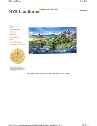
  • 1. NYS Landforms Page 1 of 1 Preview page as viewer (Mobile | Desktop) NYS Search this site NYS Landforms Home Adirondack Mountains Finger Lakes Niagara Falls Howe Caverns Thousand Islands Moraines and Drumlins Glaciers Teacher Page Rubrics and Student Forms Google Maps Landform Locations This project exceeds the requirements set forth in the assignment and receives this seal of excellence in recognition of work well done. Sign in | Recent Site Activity | Report Abuse | Print Page | Remove Access | Powered By Google Sites https://sites.google.com/site/nyslandforms/home?previewAsViewer=1 7/8/2012
  • 2. Adirondack Mountains - NYS Landforms Page 1 of 1 Preview page as viewer (Mobile | Desktop) NYS Search this site NYS Landforms Home Adirondack Mountains Adirondack Mountains Finger Lakes Niagara Falls Towering above New York's landscape, the Adirondack Howe Caverns Mountains stand as a monument to Thousand Islands the ice age. Five million years ago, Moraines and Drumlins small alpine glaciers carved their Glaciers way through the Northeastern United States. As they moved Teacher Page through what is now the Adirondack Rubrics and Student Forms Region, stones deposited by the Google Maps Landform Locations glacier were scattered across the landscape. Massive chunks of ice broke away from the glacier, and were buried beneath sand and gravel washed from the ice. As these ice chunks melted, depressions, called kettle holes, were formed. When the kettle hole extended below the water table, a pond was created. Many of the small, circular ponds you see while hiking in the high peak began as kettle holes. Over thousands of years, as glaciers carved away the landscape, the mountains began to take shape. Unlike the Rockies and the Appalachians, the Adirondack Mountains do not form a connected range, but rather a 160-mile wide dome of more than 100 peaks. Although the mountains are formed from ancient rocks more than 1,000 million years old, geologically, the dome is a newborn. The Adirondack Peaks can be anywhere from 1,200 feet This project exceeds the tall to well over 5,000 feet tall, and the 46 tallest summits above 4,000 feet are called the High Peaks. Although requirements set forth in the four peaks were later discovered to measure less than 4,000 feet, they are still considered Adirondack High assignment and receives this seal Peaks. of excellence in recognition of work well done. The highest of all the peaks is Mount Marcy, towering 5,344 feet above sea level. It is one of the most distinctive features of the Adirondack landscape. Mount Marcy is home to Lake Tear of the Clouds, the highest lake in New York State at 4,292 feet, and the source of the Hudson River. The Adirondack Mountains are about 6 million acres of forests, streams, rivers, lakes, and mounatins. They are located in Northern New York, about 225 miles north of New York City and 75 miles south of Montreal, Canada. In 1892 the Adirondacks were named a State Park. (Ref: http://visitadirondacks.com/adirondack-mountains.html) Interesting Facts About the Adirondack Mountains • Mt. Marcy is the tallest of the Adirondack Mountains at 5,344 ft. • There are 2,000 miles of foot trails. • There are 2,300 lakes & ponds. • There are 1,500 miles of rivers. Sign in | Recent Site Activity | Report Abuse | Print Page | Remove Access | Powered By Google Sites https://sites.google.com/site/nyslandforms/about-us?previewAsViewer=1 7/8/2012
  • 3. Finger Lakes - NYS Landforms Page 1 of 1 Preview page as viewer (Mobile | Desktop) NYS Search this site NYS Landforms Home Finger Lakes Adirondack Mountains Finger Lakes Niagara Falls The Finger Lakes are made up of eleven lakes. Their Howe Caverns names, from east to west, are: Thousand Islands Otisco, Skaneateles, Owasco, Moraines and Drumlins Cayuga, Seneca, Keuka, Glaciers Canandaigua, Honeoye, Canadice, Hemlock, and Teacher Page Conesus. They are called finger Rubrics and Student Forms lakes because they are shaped Google Maps Landform Locations like the fingers of a hand. During the last Ice Age, the ice was over a mile thick. As time went on, the ice sheet grew and with its force created valleys, lakes, rivers, and even rounded mountain ranges. As this glacier withdrew, it carved out valleys. Then, as the glacier melted, the waters began to fill these new valleys forming the Finger Lakes. The deep weight of the glacier made some parts of this area deeper than others. The Finger Lakes are stretched in the direction of the ice movement. This is how the different shapes and sizes of the Finger Lakes came to be. (Ref: http://www.fingerlakes.org/) Interesting Facts About the Finger Lakes This project exceeds the requirements set forth in the assignment and receives this seal • Cayuga Lake is 40 miles long and 1 to 3 miles wide, 435 feet deep and 380 feet above sea level. of excellence in recognition of • Cayuga and Seneca Lake are connected at their northern ends by a canal. work well done. • The Finger Lakes are home to more than 100 wineries. Sign in | Recent Site Activity | Report Abuse | Print Page | Remove Access | Powered By Google Sites https://sites.google.com/site/nyslandforms/finger-lakes?previewAsViewer=1 7/8/2012
  • 4. Niagara Falls - NYS Landforms Page 1 of 1 Preview page as viewer (Mobile | Desktop) NYS Search this site NYS Landforms Home Niagara Falls Adirondack Mountains Finger Lakes Niagara Falls During the last ice age, a large sheet of ice covered Howe Caverns Canada and parts of New Thousand Islands York. As this sheet of ice Moraines and Drumlins started to melt, water began Glaciers to flow back to the ocean through a channel that went Teacher Page across New York to the Rubrics and Student Forms Hudson River Valley. As the Google Maps Landform Locations flow continued, the water levels began to drop. Eventually, a new channel was exposed which would become the Niagara River. Water from Lake Erie now flowed into Lake Iroquois (the name for a lake that stood where Lake Ontario is but was larger). As the last remaining parts of the sheet of ice melted from the Thousand Islands, a great rush of water drained Lake Iroquois through the St. Lawrence River and emptied into the Atlantic Ocean. Now the waters flowed from Lake Erie through the Niagara River into Lake Ontario and out the St. Lawrence River to the Atlantic Ocean. (Ref: http://www.niagarafallsstatepark.com/Formation-and-Discovery.aspx) This project exceeds the Interesting Facts About Niagara Falls requirements set forth in the assignment and receives this seal • A 7 year old boy wearing only life jacket and bathing suit accidentally went over the Canadian Falls and of excellence in recognition of survived during the summer of 1960. work well done. • More than 6 million cubic feet of water goes over the falls every minute during peak daytime hours. • Niagara Falls is comprised of three waterfalls: American Falls, Bridal Veil Falls and Horseshoe Falls. • The Canadian Falls, shaped like a horseshoe, are 177 feet high and the American Falls are184 feet high. Sign in | Recent Site Activity | Report Abuse | Print Page | Remove Access | Powered By Google Sites https://sites.google.com/site/nyslandforms/niagara-falls?previewAsViewer=1 7/8/2012
  • 5. Howe Caverns - NYS Landforms Page 1 of 1 Preview page as viewer (Mobile | Desktop) NYS Search this site NYS Landforms Home Howe Caverns Adirondack Mountains Finger Lakes Howe Caverns is a limestone cave Niagara Falls located the eastern central part in Howe Caverns Schoharie County 156 feet underground. Since it is so far Thousand Islands underground, the temperature stays Moraines and Drumlins at 52 °F year round. Caverns are Glaciers very humid, which means they are Teacher Page not only cool but also damp. To explore the caverns you need to Rubrics and Student Forms take a 32 second elevator ride Google Maps Landform Locations underneath the earth. These caverns stretch a little less than a mile and end at an underground lake. During tours of the caverns, after walkting to the end, you are allowed to take a short boat ride on the underground lake. Like other landforms, Howe Caverns took a long time to form. At one time, this area would have been a solid piece of limestone. Over time, rain found its way into the limestone. As the rain fell from the sky it absorbed carbon dioxide and turned into a very weak carbonic acid. This acidic water slowly dissolved the limestone over thousands of years. As a result, chambers, rooms, and passageways were carved out ultimately creating the cavern as we know it today. (Ref: http://howecaverns.com/history) This project exceeds the Intersting Facts About Howe Caverns requirements set forth in the assignment and receives this seal • Lester Howe accidentally found Howe Caverns on May 22, 1842. Howe noticed that his cows seemed to be of excellence in recognition of grazing in the same spot every day. When he went to find out why, the temperature seemed to be quite work well done. cooler where the cows were grazing. As he approached that same spot, he found an opening to the cave all because of one cow named Milicent that stood closest to the opening. • Howe Caverns has little animal or plant life. It is a closed ecological system, which means that the food web stays only in the cave. • Unique stone formations grow deep inside the caverns. Large formations known as stalactites grow down from the cavern ceilings. Large formations known as stalagmites grow up from the ground. (A neat way to learn the meanings of these terms and not be confused is to remember the “c” (grows down from ceiling) in stalactites and the “g” (grows up from ground) in .stalagmites. Sign in | Recent Site Activity | Report Abuse | Print Page | Remove Access | Powered By Google Sites https://sites.google.com/site/nyslandforms/howe-caverns?previewAsViewer=1 7/8/2012
  • 6. Thousand Islands - NYS Landforms Page 1 of 1 Preview page as viewer (Mobile | Desktop) NYS Search this site NYS Landforms Home Thousand Islands Adirondack Mountains Finger Lakes Niagara Falls How many islands make up the Thousand Islands? Howe Caverns There are at least 1,700 Thousand Islands islands between Canada and Moraines and Drumlins the United States in the Glaciers region called Thousand Islands in the St. Lawrence Teacher Page River. Most of the islands Rubrics and Student Forms are relatively small, but there Google Maps Landform Locations are a few that stretch 5 to 6 miles long. These islands are found in about a 40-mile stretch on the river where it turns very wide as it leaves Lake Ontario. The Thousand Islands reach the Canadian side from Wolfe Island near Kingston, Ontario to Brockville, Ontario and goes over to the American side from Tibbets Point on Lake Ontario to Morristown, New York. Long before the French explorers found this area, this land was occupied by the five member nations of the Iroquois. This included the Mohawk, Oneida, Onondaga, Seneca, and the Cayuga Indians. This project exceeds the requirements set forth in the During the last Ice Age, which happened about 18,000 years ago, the ice was over a mile thick. As time went on, assignment and receives this seal the ice sheet grew and with its force, created valleys, lakes, rivers, and even rounded mountain ranges when it of excellence in recognition of began to withdraw. It also crushed things that did not move like a huge bulldozer. As it withdrew, the glacier left work well done. a large channel to the valley. As the glacier melted, the waters began to fill this new channel. The deep weight of the glacier made some parts of this area deeper than others. This is how the different shapes and sizes of the Thousand Islands came to be. (Ref: http://oliver_kilian.tripod.com/1000islands/IsIn2-Rocks/rocks.htm) Interesting Facts About the Thousand Islands • There are at least 1,700 islands that make up the Thousand Islands. • Seventeen of these islands are included in the St. Lawrence Islands National Park. • First European settlement in this area was located in Kingston in 1675, with the opening of Fort Frontanac. Sign in | Recent Site Activity | Report Abuse | Print Page | Remove Access | Powered By Google Sites https://sites.google.com/site/nyslandforms/thousand-islands?previewAsViewer=1 7/8/2012
  • 7. Moraines and Drumlins - NYS Landforms Page 1 of 1 Preview page as viewer (Mobile | Desktop) NYS Search this site NYS Landforms Home Moraines and Drumlins Adirondack Mountains Finger Lakes Niagara Falls The "Ice age" was really a Howe Caverns series of many advances and retreats of glaciers. Thousand Islands The Finger Lakes were Moraines and Drumlins probably carved by several Glaciers of these episodes. Ice Teacher Page sheets more than two miles thick flowed southward, Rubrics and Student Forms parallel but opposite to the Google Maps Landform Locations flow of the rivers, gouging deep trenches into these river valleys. Traces of most of the earlier glacial events have vanished, but much evidence remains of the last one or two glaciers that covered New York. The latest glacial episode was most extensive around 21,000 years ago, when glaciers covered almost the entire state. Around 19,000 years ago, the climate warmed, and the glacier began to retreat, disappearing entirely from New York for the last time around 11,000 years ago. The most obvious evidence left by the glaciers are the gravel deposits at the south ends of the Finger Lakes called moraines and streamlined elongated hills of glacial sediment called drumlins. Moraines are visible south of Ithaca at North Spencer, along Route 13 west of Newfield, and near This project exceeds the Willseyville. Drumlins are visible northeast of Ithaca at the northern end of Cayuga and Seneca requirements set forth in the lakes in a broad band from Rochester to Syracuse. (Ref: assignment and receives this seal http://www.britannica.com/EBchecked/topic/172086/drumlin) of excellence in recognition of work well done. Interesting Facts About Morains and Drumlins • The long axis of a drumlin lies parallel to the direction of the advance. • Drumlins can vary widely in size, with lengths from 0.6 to 1.2 miles, heights from 50 to 100 feet, and widths from 1300 to 2000 feet. • Most drumlins are composed of till, but they may vary greatly in their composition. Some contain significant amounts of gravels, whereas others are made up of rock underlying the surface till. Sign in | Recent Site Activity | Report Abuse | Print Page | Remove Access | Powered By Google Sites https://sites.google.com/site/nyslandforms/moraines-and-drumlins?previewAsViewer=1 7/8/2012
  • 8. Glaciers - NYS Landforms Page 1 of 1 Preview page as viewer (Mobile | Desktop) NYS Search this site NYS Landforms Home Glaciers Adirondack Mountains Finger Lakes Niagara Falls Even though you've probably never seen a glacier, they are a Howe Caverns big item of importance when we Thousand Islands talk about New York State's Moraines and Drumlins geology. Glaciers In a way, glaciers are just frozen Teacher Page rivers of ice flowing downhill. Rubrics and Student Forms Glaciers begin life as Google Maps Landform Locations snowflakes. When the snowfall in an area far exceeds the melting that occurs during summer, glaciers start to form. The weight of the accumulated snow compresses the fallen snow into ice. These "rivers" of ice are tremendously heavy, and if they are on land that has a downhill slope the whole ice patch starts to slowly grind its way downhill. Even when they are melting and receeding they maintain their downhill movement. These glaciers can vary greatly in size, from a football-field sized patch to a river a hundred miles long. Glaciers have had a profound effect on the topography in NYS, other states in the northern U.S and in Canada. Imagine how a billion-ton ice cube can rearrange the landscape as it slowly grinds its way overland. In this picture This project exceeds the requirements set forth in the you can see the bowl-shaped valley in a glacial valley glacier forces its way through the landscape. Many lakes, assignment and receives this seal such as the Great Lakes, and valleys have been carved out by ancient glaciers. (Ref: of excellence in recognition of http://ga.water.usgs.gov/edu/earthglacier.html) work well done. Interesting Facts About the Glaciers • During the last ice age (when glaciers covered more land area than today) the sea level was about 400 feet lower than it is today. At that time, glaciers covered almost one-third of the land. • During the last warm spell, 125,000 years ago, the seas were about 18 feet higher than they are today. About three million years ago the seas could have been up to 165 feet higher. • Glaciers store about 69% of the world's freshwater, and if all land ice melted the seas would rise about 70 meters (about 230 feet). • Sign in | Recent Site Activity | Report Abuse | Print Page | Remove Access | Powered By Google Sites https://sites.google.com/site/nyslandforms/glaciers?previewAsViewer=1 7/8/2012
  • 9. Teacher Page - NYS Landforms Page 1 of 2 Preview page as viewer (Mobile | Desktop) NYS Search this site NYS Landforms Home Teacher Page Adirondack Mountains Finger Lakes Overview Niagara Falls Howe Caverns Note: This is one piece of what could be a full year project with each unit. It will be important for the teacher to be aware of each student’s situation so that alterations can be made for the independent portion if necessary. Thousand Islands Students will be working in groups, independently and with technology as well as making real world observations Moraines and Drumlins and practicing real world reporting. Ideally this project could be taken on by schools across the state or country Glaciers and students could share their local landforms with each other. Teacher Page As students progress through a unit on landforms, they will use their observation skills in a real world Rubrics and Student Forms application and then report their findings. Students will make observations, recall or research the processes that Google Maps Landform Locations created the landforms, utilize digital photography, GPS technology and create a personal review website. Students will participate in a field trip to at least 3 local landforms that are discussed in class. At the end of the unit (following the field trip) each student will be responsible for creating their own website that will include their authentic photograph of the landform, their observations, formation information, GPS location, and three facts about the landform that the student found interesting. Students will work in groups of 3 to photograph, take GPS coordinate readings of their location, map it on a map (perhaps Google Earth) and make authentic observations. In addition to the 3 landforms observed on the field trip, each student will be required to independently seek out 1 additional landform and complete all the previously mentioned components. Each student will then share their information on the landform with the others in their group. It will be the responsibility of each student to verify that the information that they include on their website is accurate and complete. If a student is unable to seek out a local landform on their own due to a lack of transportation or family responsibility, they will be allowed to research and use an available image of a well known landform. After the websites are completed, the teacher will grade them with the use of a rubric. Badges will be awarded as follows: 1-the teacher will award a “Teachers Seal of Excellence” to websites that meet and or surpasses all required elements. 2- Each student will view all classmates’ websites and choose a favorite. The one This project exceeds the with the most votes will be awarded a “Class Favorite” badge. requirements set forth in the Additionally, each student will be required to peer review 3 other students work (these may NOT be group assignment and receives this seal members). Students will use the Peer Review Form. of excellence in recognition of The goals of this project are to get students out of the classroom to actually see, touch and experience the work well done. landforms they have learned about and to work on their observation and reporting skills. Students will also benefit from group work and the sharing of their finding of their individual component. Prior Knowledge and Standards As students begin this project, they will need some prior knowledge to successfully complete it. Students will need to understand that Landforms are the result of Earth processes and time. Students will need to have a basic knowledge of GPS and what it is used for as well as an understanding of how to make and report observations. Students will be exposed to many NYS standards during this project. Standard 2: Information Systems Key Idea 1: Information technology is used to retrieve, process, and communicate information as a tool to enhance learning. Key Idea 2: Knowledge of the impacts and limitations of information systems is essential to its effective and ethical use. Standard 6: Interconnectedness, Common Themes: Key Idea 1: Systems Thinking: Through systems thinking, people can recognize the commonalities that exist among all systems and how parts of a system interrelate and combine to perform specific functions Key Idea 3: Magnitude and Scale: The grouping of magnitudes of size, time, frequency, and pressures or other units of measurement into a series of relative order provides a useful way to deal with the immense range and the changes in scale that affect the behavior and design of systems. Standard 4, Key Idea 2, Performance Indicators 2.1m Many processes of the rock cycle are consequences of plate dynamics. These include the production of magma (and subsequent igneous rock formation and contact metamorphism) at both subduction and rifting regions, regional metamorphism within subduction https://sites.google.com/site/nyslandforms/teacher-page?previewAsViewer=1 7/8/2012
  • 10. Teacher Page - NYS Landforms Page 2 of 2 zones, and the creation of major depositional basins through down-warping of the crust. 2.1n Many of Earth’s surface features such as mid-ocean ridges/rifts, trenches/subduction zones/island arcs, mountain ranges (folded, faulted, and volcanic), hot spots, and the magnetic and age patterns in surface bedrock are a consequence of forces associated with plate motion and interaction. 2.1p Landforms are the result of the interaction of tectonic forces and the processes of weathering, erosion, and deposition. 2.1r Climate variations, structure, and characteristics of bedrock influence the development of landscape features including mountains, plateaus, plains, valleys, ridges, escarpments, and stream drainage patterns. 2.1t Natural agents of erosion, generally driven by gravity, remove, transport, and deposit weathered rock particles. Each agent of erosion produces distinctive changes in the material that it transports and creates characteristic surface features and landscapes. In certain erosional situations, loss of property, personal injury, and loss of life can be reduced by effective emergency preparedness. 2.1u The natural agents of erosion include: • Streams (running water): Gradient, discharge, and channel shape influence a stream’s velocity and the erosion and deposition of sediments. Sediments transported by streams tend to become rounded as a result of abrasion. Stream features include V-shaped valleys, deltas, flood plains, and meanders. A watershed is the area drained by a stream and its tributaries. • Glaciers (moving ice): Glacial erosional processes include the formation of U-shaped valleys, parallel scratches, and grooves in bedrock. Glacial features include moraines, drumlins, kettle lakes, finger lakes, and outwash plains. • Wave Action: Erosion and deposition cause changes in shoreline features, including beaches, sandbars, and barrier islands. Wave action rounds sediments as a result of abrasion. Waves approaching a shoreline move sand parallel to the shore within the zone of breaking waves. • Wind: Erosion of sediments by wind is most common in arid climates and along shorelines. Wind-generated features include dunes and sand-blasted bedrock. • Mass Movement: Earth materials move downslope under the influence of gravity. 2.1v Patterns of deposition result from a loss of energy within the transporting system and are influenced by the size, shape, and density of the transported particles. Sediment deposits may be sorted or unsorted. Teacher overview.pdf Benjamin Rosenthal, v.1 Sign in | Recent Site Activity | Report Abuse | Print Page | Remove Access | Powered By Google Sites https://sites.google.com/site/nyslandforms/teacher-page?previewAsViewer=1 7/8/2012
  • 11. Rubrics and Student Forms - NYS Landforms Page 1 of 1 Preview page as viewer (Mobile | Desktop) NYS Search this site NYS Landforms Home Rubrics and Student Forms Adirondack Mountains Finger Lakes Landforms Project Niagara Falls Howe Caverns You will be putting your observation and reporting skills to work and creating your own review website that will help you get to know the wondrous world right outside your door! Thousand Islands Moraines and Drumlins As we move through our unit on landforms, we will be continually working towards each of you creating Glaciers your own website. Your website will include several components that will be useful to you especially when you Teacher Page begin to review for the final exam. Rubrics and Student Forms You will be put into groups of 3. when we take our field trip to some local landforms, your group will be required to: Google Maps Landform Locations a. take a photograph of the landform, b. take a GPS coordinate reading, c. pin point the GPS reading on a map that will be put onto each of your websites, d. make authentic observations and write them into your journals. *You each will also be adding 3 interesting facts about each landform to your individual sites After the field trip you each will make your own website using the information that you gathered along with your independent landform observation and photo. Each of you will be required to individually seek out, identify, photograph, observe and describe one landform other than the ones found on the field trip. ***Attached is the rubric that explains the project and my expectations. Please see me if you have any questions or do not fully understand the project or directions.*** This project exceeds the requirements set forth in the assignment and receives this seal of excellence in recognition of Earth Science Reference Tables - 2011.pdf Benjamin Rosenthal, v.1 work well done. Peer Review Doc.pdf Benjamin Rosenthal, v.1 Project Rubric.pdf Benjamin Rosenthal, v.1 Student Field Trip Sheet.pdf Benjamin Rosenthal, v.1 Student overview.pdf Benjamin Rosenthal, v.1 Sign in | Recent Site Activity | Report Abuse | Print Page | Remove Access | Powered By Google Sites https://sites.google.com/site/nyslandforms/rubrics-and-student-evaluation-forms?previewAs... 7/8/2012
  • 12. The University of the State of New York • THE STATE EDUCATION DEPARTMENT • Albany, New York 12234 • www.nysed.gov Reference Tables for Physical Setting/EARTH SCIENCE Radioactive Decay Data Specific Heats of Common Materials RADIOACTIVE DISINTEGRATION HALF-LIFE MATERIAL SPECIFIC HEAT ISOTOPE (years) (Joules/gram • °C) 14 14 3 Liquid water 4.18 Carbon-14 C N 5.7 × 10 Solid water (ice) 2.11 40 40 Ar 9 Water vapor 2.00 Potassium-40 K 40 1.3 × 10 Ca Dry air 1.01 238 206 9 Uranium-238 U Pb 4.5 × 10 Basalt 0.84 10 Granite 0.79 87 87 Rubidium-87 Rb Sr 4.9 × 10 Iron 0.45 Copper 0.38 Equations Lead 0.13 distance between foci Eccentricity = Properties of Water length of major axis change in field value Heat energy gained during melting . . . . . . . . . . 334 J/g Gradient = distance Heat energy released during freezing . . . . . . . . 334 J/g change in value Heat energy gained during vaporization . . . . . 2260 J/g Rate of change = time Heat energy released during condensation . . . 2260 J/g mass Density = Density at 3.98°C . . . . . . . . . . . . . . . . . . . . . . . . 1.0 g/mL volume Average Chemical Composition of Earth’s Crust, Hydrosphere, and Troposphere ELEMENT CRUST HYDROSPHERE TROPOSPHERE (symbol) Percent by mass Percent by volume Percent by volume Percent by volume Oxygen (O) 46.10 94.04 33.0 21.0 Silicon (Si) 28.20 0.88 Aluminum (Al) 8.23 0.48 Iron (Fe) 5.63 0.49 Calcium (Ca) 4.15 1.18 Sodium (Na) 2.36 1.11 Magnesium (Mg) 2.33 0.33 Potassium (K) 2.09 1.42 Nitrogen (N) 78.0 Hydrogen (H) 66.0 Other 0.91 0.07 1.0 1.0 2011 EDITION Eurypterus remipes This edition of the Earth Science Reference Tables should be used in the classroom beginning in the 2011–12 school year. The first examination for which these tables will be used is the January 2012 Regents Examination in New York State Fossil Physical Setting/Earth Science.
  • 13. Generalized Landscape Regions of New York State ds Interior an wl Grenville Province Lowlands e Lo (Highlands) e nc awr S t. L Interior Lowlands Adirondack Mountains Champlain Lowlands Lake Ontario Tug Hill Plateau ce Physical Setting/Earth Science Reference Tables — 2011 Edition in Erie-Ontario Lowlands (Plains) d ov s) s an Pr Lake Erie hl ig and untain En (H gl Allegheny Plateau Lowlands ew N nic Mo The Catskills Mohawk Taco o n- s) nds nd ighla a on H Huds pl H uds ng ( U n Pro u hatta Man ea at Key Pl Major geographic province boundary an lain al P hi st ds Landscape region boundary c Coa lan rk State boundary tic ala w N lan p At Lo ewa International boundary Ap Miles N 0 10 20 30 40 50 W E 0 20 40 60 80 Kilometers S 2
  • 14. 73° 75° 74° 45° 45° Generalized Bedrock Geology of New York State er MASSENA iv R e modified from nc re PLATTSBURGH w GEOLOGICAL SURVEY La t. NEW YORK STATE MUSEUM S 76° 1989 AIN MPL A MT. MARCY VERMONT CH 44° 44° WATERTOWN R iv e r LAKE elevation 75 m OLD FORGE on ds LAKE ONTARIO Hu 79° 78° 77° OSWEGO ROCHESTER UTICA NIAGARA FALLS Physical Setting/Earth Science Reference Tables — 2011 Edition SYRACUSE 43° ar a River 43° ag Moha wk Ni R iv e r BUFFALO r ve elevation 175 m ALBANY Ri LAKE FINGER LAKES see ERIE ne Ge ITHACA Rive r er MASSACHUSETTS iv JAMESTOWN ELMIRA BINGHAMTON R SLIDE MT. Susquehanna 42° 42° KINGSTON 79° 78° 77° 76° De Hu ds on law P E N N S Y L V A N I A are Rive r GEOLOGIC PERIODS AND ERAS IN NEW YORK CONNECTICUT 75° CRETACEOUS and PLEISTOCENE (Epoch) weakly consolidated to unconsolidated gravels, sands, and clays NE LATE TRIASSIC and EARLY JURASSIC conglomerates, red sandstones, red shales, basalt, and diabase (Palisades sill) W UND JE ND SO PENNSYLVANIAN and MISSISSIPPIAN conglomerates, sandstones, and shales Dominantly RS SLA EY N G I 73° 41° DEVONIAN sedimentary LO 41° limestones, shales, sandstones, and conglomerates 41° RIVERHEAD 72° SILURIAN } SILURIAN also contains salt, gypsum, and hematite. origin NEW YORK D ORDOVICIAN CITY ISLAN limestones, shales, sandstones, and dolostones LONG CAMBRIAN } CAMBRIAN and EARLY ORDOVICIAN sandstones and dolostones moderately to intensely metamorphosed east of the Hudson River } Dominantly 40°30' 73° ATLANTIC OCEAN CAMBRIAN and ORDOVICIAN (undifferentiated) quartzites, dolostones, marbles, and schists 74° 73°30' metamorphosed intensely metamorphosed; includes portions of the Taconic Sequence and Cortlandt Complex rocks Miles TACONIC SEQUENCE sandstones, shales, and slates Miles N slightly to intensely metamorphosed rocks of CAMBRIAN through MIDDLE ORDOVICIAN ages 10 20 30 40 MIDDLE PROTEROZOIC gneisses, quartzites, and marbles Lines are generalized structure trends. } Intensely metamorphosed rocks 0 100 20 30 40 50 50 0 20 40 60 W 80 E MIDDLE PROTEROZOIC anorthositic rocks } (regional metamorphism about 1,000 m.y.a.) 0 20 40 60 80 Kilometers Kilometers S 3
  • 15. Surface Ocean Currents Physical Setting/Earth Science Reference Tables — 2011 Edition 4