This document discusses volcanoes and volcanic hazards. It begins with an overview of the nature of volcanic activity and different types of volcanic eruptions. It then describes common volcanic landforms such as lava flows, lava domes, and flood basalts. The document discusses different types of volcanoes including shield, composite cone, and cinder cones. It outlines volcanic hazards like lava flows, pyroclastic flows, and mudflows. The eruption of Mount St. Helens is summarized. The document concludes with a discussion of predicting eruptions through monitoring techniques.
8. 6-8
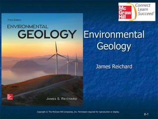
Volcanic Eruptions (3)
A. Mount St. Helens, Washington B. Kilauea, Hawaii
a: USGS; b: J.D. Griggs/U.S. Geological Survey
Jump to long description
9. 6-9
Volcanic Landforms
Lava Flows
• Small
• Large
Lava domes
Continental Flood Basalts
A. Basalt, Pu’u O’o, Hawaii B. Andesite, Lassen, California C. Rhyolite, Long Valley, California
a: Photograph by J.D. Griggs, USGS Photo Library, Denver, CO; b: Michael Clynne USGS and USDA; c: USGS
Jump to long description
22. 6-22
Mass Wasting on Volcanoes
Volcanic landslides
Volcanic mudflows
• Lahars
• Debris flows
(inset): Underwood & Underwood/Library of Congress
Jump to long description
29. 6-29
Volcanoes and Related Hazards Long Description
Three-quarters of the residents of Armero, Colombia, were killed when a massive mudflow came roaring
down a canyon and emptied out onto the valley floor where the city was built. The mudflow formed when
Nevado del Ruiz, located 46 miles (74 km) away, began to erupt, causing its glacial ice cap to melt.
Jump back to slide containing original image
30. 6-30
Nature of Volcanic Activity Long Description
How easily magma flows depends on its viscosity, which is controlled by its SiO2 content and temperature.
Shown here is high-temperature, silica-poor basaltic magma of relatively low viscosity. Photo taken during
the 1989 eruption of Kilauea volcano, Hawaii.
Jump back to slide containing original image
31. 6-31
Magma and Plate Tectonics Long Description
Location of active volcanoes and their relationship to tectonic plate boundaries. Most volcanoes derive their
magma from subduction zones or from the upper mantle in what are referred to as hot spots. Hot spot
volcanoes in an oceanic setting produce basaltic magma, and those on continents generate more rhyolitic
magma. Depending on the tectonic setting, subduction zone volcanoes will produce basaltic, andesitic, or
rhyolitic magmas.
Jump back to slide containing original image
32. 6-32
Volcanic Eruptions (1) Long Description
The viscosity of magma increases with increasing SiO2 content and decreasing temperature. Basaltic
magmas are the least viscous because they form in the upper mantle where the temperature is high and
the SiO2 content of the rocks is relatively low. Andesitic and rhyolitic magmas form at much shallower and
cooler depths and under processes that cause these magmas to become enriched in SiO2.
Jump back to slide containing original image
33. 6-33
Volcanic Eruptions (2) Long Description
Molten rock eventually accumulates in what is called a magma chamber. The weight of the overlying column
of rock creates overburden (confining) pressure, which is offset by the magma’s fluid pressure. As magma
continues to rise and encounters less overburden, the fluid pressure is able to open fractures, creating
possible pathways to the surface. At the surface the pressurized magma is allowed to expand freely.
Jump back to slide containing original image
34. 6-34
Volcanic Eruptions (3) Long Description
Volcanic eruptions occur when pressurized magma breaches the surface. Explosive eruptions (A) are
associated with more viscous and gas-charged magmas in which the dissolved gases rapidly decompress,
ejecting rock and ash into the atmosphere. Nonexplosive eruptions (B) are associated with hot fluid magma
containing less dissolved gas; in which case the eruption generates lava fountains and lava flows.
Jump back to slide containing original image
35. 6-35
Volcanic Landforms Long Description
The shape and thickness of a lava flow depend upon the magma’s viscosity and the slope of the land
surface. Low-viscosity basaltic lava flows (A) tend to travel greater distances and spread out into thin sheets
in areas where the terrain is more relatively flat. Andesitic lava is more viscous and creates thicker flows (B)
that travel relatively short distances. Highly viscous rhyolitic lava (C) hardly flows at all, but rather builds
into a mound-shaped feature called a lava dome.
Jump back to slide containing original image
36. 6-36
Flood Basalt Long Description
Extensive lava flows, called flood basalts, form when large volumes of highly fluid basaltic magma are
extruded, usually along fracture zones. The map shows the extent of the Columbia River flood basalts in the
Pacific Northwest region of the United States. These extensive flows reach a thickness of over 2,000 feet
(600 m). The Cascade Range is a volcanic arc that contains subduction zone volcanoes.
Jump back to slide containing original image
37. 6-37
Volcanoes Long Description
A volcanic vent can coincide with a fault or fracture, resulting in a linear extrusion known as a fissure
eruption (A). In other cases the vent is a single opening whereby the ejected material creates the familiar
coneshaped feature known as a volcano (B).
Jump back to slide containing original image
38. 6-38
Shield Volcanoes Long Description
Shield volcanoes (A) are composed primarily of basaltic lava flows that accumulate over geologic time.
Photo shows Mauna Loa (B) in the Hawaiian Islands, which sits over a hot spot, providing a steady supply
of magma that has allowed it to grow to 14,400 feet (4,400 m) above sea level.
Jump back to slide containing original image
39. 6-39
Composite cone volcanoes Long Description
Composite cone volcanoes (A) are composed of alternating layers of pyroclastic material and lava flows.
Viscous andesitic lavas tend to form short and thick flows that enable the volcano to maintain steep slopes
and reach great heights. Composite cones are typically quite symmetrical, like Mount Fuji (B) in Japan.
Jump back to slide containing original image
40. 6-40
Size comparison Long Description
Size comparison of one of the larger composite cones in the Cascade Range, Mount Rainier, with the shield
volcanoes on the island of Hawaii (see Case Study 6.1).
Jump back to slide containing original image
41. 6-41
Hawaiian Hot Spot Long Description
The Hawaiian Islands are part of a long chain of islands and submerged volcanic remnants known as the
Hawaiian Ridge–Emperor Seamount chain. The active shield volcanoes on the big island of Hawaii are
currently situated over a stationary mantle plume, which has been generating basaltic magma for
approximately 70 million years while the Pacific plate slowly moves to the northwest.
Jump back to slide containing original image
42. 6-42
Yellowstone Hot Spot Long Description
Map (A) showing the location of ancient calderas associated with the Yellowstone hot spot. Yellowstone
National Park is the site of the most recent caldera, which formed after a colossal eruption 640,000 years
ago. Cross section (B) showing how rising basaltic magma from the hot spot can cause melting of granitic
crust, resulting in a rhyolitic magma chamber. The accumulation of new magma and release of hot fluids
are believed to be responsible for recent earthquake activity and changing land elevations within the
caldera.
Jump back to slide containing original image
43. 6-43
Calderas Long Description
Calderas form (A) when magma is ejected from a shallow magma chamber, leaving its roof unsupported
and eventually causing it to collapse. Photo (B) shows the water-filled caldera of Crater Lake in the Cascade
Range in Oregon.
Jump back to slide containing original image
44. 6-44
Volcanic Hazards (1) Long Description
Lava flows cause considerable damage when they bury valuable real estate and infrastructure, such as the
highway and personal property shown in (A). Flows are also destructive when they encounter combustible
materials and cause them to catch fire, as in the case of Volcanoes National Park Visitor Center in Hawaii
(B).
Jump back to slide containing original image
45. 6-45
Volcanic Hazards (2) Long Description
Pyroclastic flows are dry, hot avalanches where large rock fragments tumble along the ground surface and
are overlain by a flowing cloud of finer fragments and droplets of lava. Mixed with these materials are
superheated gases, creating a flow that will obliterate and incinerate everything in its path. The illustrations
show some of the ways pyroclastic flows form during either explosive or nonexplosive events.
Jump back to slide containing original image
46. 6-46
The eruption of Mount St. Helens (1) Long Description
The eruption of Mount St. Helens was triggered by a small earthquake, which caused a landslide (A) over a
bulge that had formed on the side of the volcano. Once the landslide removed the weight of this overlying
rock (B), dissolved gases within the highly pressured magma were allowed to rapidly expand. Because of
the location of the bulge, the initial blast was directed horizontally (C), devastating the landscape.
Jump back to slide containing original image
47. 6-47
The eruption of Mount St. Helens (2) Long Description
Graph comparing the volume of ash ejected in selected volcanic eruptions that have occurred in the recent
geologic past.
Jump back to slide containing original image
48. 6-48
Mass Wasting on Volcanoes Long Description
St. Pierre was once a thriving seaport on the island of Martinique in the Caribbean. Then in 1902 a
pyroclastic flow raced down nearby Mount Pelée and incinerated the city and its entire population of 30,000.
Jump back to slide containing original image
49. 6-49
Large volcanic mudflows Long Description
Large volcanic mudflows can form when a landslide develops beneath a glacial ice cap on a composite
cone. Such landslides can be triggered when magma creates an unstable bulge in the mountainside, or
when slopes are weakened by gases and hot fluids that turn solid rock into clay minerals.
Jump back to slide containing original image
50. 6-50
The Seattle-Tacoma area is under extreme
risk Long Description
Mount Rainier in Washington state is an active composite cone whose snow- and ice-capped summit
contains more water than all the other Cascade volcanoes combined. This volcano has a history of
generating extremely large mudflows, as illustrated by the map showing ancient mudflow deposits in river
valleys leading up to the volcano’s summit. Many rapidly growing communities in the Seattle-Tacoma
metropolitan area are at extreme risk as they are located within river valleys draining Mount Rainer.
Jump back to slide containing original image
51. 6-51
The Cascade Range in the Pacific NorthwestLong Description
The Cascade Range in the Pacific Northwest contains active stratovolcanoes associated with a subduction
zone. Most of these volcanoes have erupted in the recent geologic past; some like Mount St. Helens erupt
more frequently.
Jump back to slide containing original image
52. 6-52
Predicting Eruptions Long Description
a) The monitoring of magmatic earthquakes and volcanic gases is key in predicting volcanic eruptions.
Portable seismographs record the rhythmic vibrations of magmatic earthquakes and allow scientists to
track the magma body as it pushes up through the crust. Measuring the chemistry of gas samples
collected at the surface helps determine whether the magma is new, and hence potentially more
explosive.
b) A seismograph recording showing numerous magmatic earthquakes taking place on Mount St. Helens.
Jump back to slide containing original image