6. נגמרה ההפשרה מצחיק
But a funny thing began occurring in 2013: the Jakobshavn’s ice front
stopped thinning and instead began thickening and the trend continued
through 2017, according to the European Space Agency, which
monitors the glacier with various satellites as part of its Climate Change
Initiative. That means the glacier is now flowing more slowly and is no
longer retreating inland.
“It’s a complete reversal in behavior and it wasn’t predicted,”
"The rate of sea-level contribution from Greenland has slowed in recent
years and it’s because some of the biggest ice evacuators like
Jakobshavn aren’t contributingas much as they used to.”
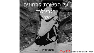
7. ממש האחרונה השנה של מצב תמונת1.9.2019-31.8.2020
Map shows the difference between the annual SMB
in 2019-20 and the 1981-2010 period (in mm of ice
melt).Blue shows more ice gain than average and red
shows more ice loss than average. Credit: DMI Polar
Portal.
במפה עין מבט לפי רק,
יותר יש מה לומר מאוד קשה
אחד שכל ובעיקר כחול או אדום
רווח מייצג מהגוונים/שונה הפסד.
8. Timeseries of ice discharge from the Greenland Ice Sheet. Dots represent when observations
occurred, and grey bars show the uncertainty. The orange stepped line is the annual average. Data is
updated monthly and available to download from here. Source: Mankoff et al (2020).
של של מצב תמונת"זרימת"בשנים לים מגרינלנד קרח1986-2020
ה שנות תחילת מאז-2000קבועה כמעט השנתית הכמות.
9. Cumulative surface mass budget of the Greenland ice sheet for 2019-20 (blue line), the record low SMB
year of 2011-12 (red), and the 1981-2010 average (grey). Credit: DMI Polar Portal.
האחרונה בשנה הקרח מאזן התנהגות,לשנים הממוצעת ההתנהגות לעומת1981-2010.
ספטמבר בחודשים-הממוצע כמו השנה דצמבר,ינואר בחודשים-קרח פחות היה השנה יולי,
לממוצע שווה הכמות שוב באוגוסט אך.
10. בשנים גדל יעקובסון קרחון רק לא
האחרונות,הנראה פיטרמן קרחון גם
השנים בין גדל כאן2012-2017.
Growth of Greenland's Petermann Glacier during the past five years as
revealed by NASA/MODIS satellite imagery from a low point in August
11. בשנים בגרינלנד הקרח במסת השינוי1992-2018.
מאז2011עלייה של מגמה יש.
Rate of mass change (dM/dt, where M is mass and t time) of the Greenland Ice Sheet determined from the satellite-altimetry, input–output
method and gravimetry assessments included in this study. In each case, dM/dt is computed at annual intervals from time series of relative mass
change using a 3-yr window. An average of the estimates across each measurement technique is also shown for each year (black line). The
estimated 1σ, 2σ and 3σ ranges of the class average are shaded in dark, mid and light grey, respectively; 97% of all estimates fall within the
1σ range, given their estimated individual errors. The equivalent sea-level contribution of the mass change is also indicated (right vertical axis),
and the number of individual mass-balance estimates collated at each epoch is shown below each bar.