Mira Road Memorable Call Grls Number-9833754194-Bhayandar Speciallty Call Gir...
Renaud_CGIAR DIDX (2022).pptx
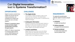
1. Can Digital Innovation
lead to Systems Transformation?
OPPORTUNITIES
Digital Innovations provide timely
insights and services that can
improve productivity, and
profitability and manage risks
across food, land, and water
systems.
Evidence is required to inform
current and future digital
transformation processes
through research.
DI/DX in ST offers an opportunity
to coordinate digital research
across CGIAR Initiatives and
synergize their R4D efforts.
CHALLENGES
The digital divide
The potential of digital innovation is clear, yet its
reach is far from universal. The Global South,
especially women and rural areas, is underserved by
digital technologies.
Inadequate information
Real-time monitoring of food-land-water systems is
possible at a lower cost and higher accuracy than
ever before, yet decision-makers lack access to
timely, reliable, and actionable information.
Limited capabilities
Digital literacy and skill levels across the Global
South remain low, particularly among the most
marginalized and food-insecure individuals, such as
women, youth, and indigenous groups.
REQUIREMENTS
To realize the transformative
potential, digital innovations should
be __________________.
1. Inclusive
to reach and benefit all
2. Action-oriented
to support informed decisions
3. Human-centered
to meet actual needs and
improve people’s lives
2. Work Packages
1
ENABLING
ENVIRONMENT FOR
DIGITAL ECOSYSTEMS
2
BRIDGING THE GENDER
DIGITAL DIVIDE
3
SYSTEM DYNAMICS
MODELING FOR NRM
MANAGEMENT
4
REAL-TIME MONITORING
OF FOOD SYSTEMS
5
ENABLING DIGITAL
PLATFORMS AND
SERVICES
Leads Andrea Gardeazabal,
Carlo Azzarri
Simon Langan.
Deepa Joshi
Jawoo Koo.
Chris Dickens
Daniel Jimenez,
Steve Kemp
Sheetal Sharma,
Ram Dhulipala
Focus Support policymakers
and investors to build
enabling environments
(including policies,
investment plans,
innovation support
systems, and public-private
partnerships) for
strengthening local
digital ecosystems.
Support digital innovators
by measuring and
assessing the gender-
responsiveness of their
services and providing
research-based solutions
that can lead to reducing
the gender digital divide
and empowering users.
Support natural resource
management authorities
by co-developing a real-
time decision-support
system to monitor water
use across food, land,
and water systems and
issue actionable early
warnings for timely
management of risks.
Support food value-chain
stakeholders by generating
and incorporating real-time
monitoring of food
production and supply
system dynamics data into
information systems and
developing strategies toward
climate-smart agrifood
systems.
Support digital
innovators (CGIAR and
partners) by coordinating
the delivery of enabling
data and analytics on
underutilized data assets,
improving the quality and
efficiency of digital
innovations, and
generating new insights
for impacts.
Countries Guatemala, Kenya,
Ethiopia
Guatemala, Kenya,
Indonesia
Mozambique, Zimbabwe,
South Africa
Guatemala, Egypt, Rwanda,
India, Indonesia
Kenya, India, Ghana,
Indonesia
3. WP4. Rice Production Monitoring Platform in Egypt
RIICE – Remote sensing based Information and Insurance for
Crops in Emerging Economies (since 2011)
→ Leverage digital technologies like remote sensing, crop
modeling, web platforms to generate information on rice production
provide to governments updated and reliable
information on rice (crop) production
monitor within season rapidly and timely flood and
drought impacts on crop performance
support upscale and site-specific climate smart activities
secure farmer income by facilitating insurance scheme
(and timing) for drought and flood damages
BASELINE
• Agricultural and rice area
• Zoning of ecosystems
• Cropping intensity
SEASONAL YIELD
• Forecasted yield
• Estimated yield at
harvest
SEASONAL AREA
• Rice cultivated area
• Phenology
• Biophysical parameters
HISTORICAL EVENTS
SEASONAL DAMAGES
• Flooding
• Drought
Information / maps delivered
4. Sentinel SAR data guaranteed i) data availability (clouds) and ii)
long term service (2030 & beyond)
Spatially explicit & accurate high resolution data (1-2ha) at
national scale, can be aggregated at any (admin) scale
Products available early during the season (mid-season) and
soon after harvest (2-3 weeks)
Yield assessment based on measured crop seasonal
performance, integrating climatic conditions and events
Field validated performance
Successful experiences in different agricultural contexts, e.g.
Cambodia, India, Philippines, Vietnam
Consistent and comparable approach across countries (same
data and methods), but system must be locally calibrated
Integration of Remote Sensing and Crop Modelling
5. Pilot Know-how transfer Upscaling Institutionalization Use
RIICE technology
has been develo-
ped in SE-Asia
and today it is
operated in
three countries
and three states
RIICE technology
is tested,
extended, and
validated in
diverse rice eco-
systems in Egypt
The RIICE service
is transferred to
a local partner,
typically a team
within the MoA
The local partner
is trained to
operate the
RIICE service and
it is
continuously
supported by the
RIICE team
• I n f o r m a t i o n i s i n s t i t u t i o n a l i z e d , d i s s e m i n a t e d a n d u s e d
• K n o w - h o w t r a n s f e r a n d e m p o w e r m e n t
RIICE products
are technically
accepted
The local partner
operates the
RIICE service
with the support
of the RIICE
team
The RIICE service
is institutionally
accepted
A Long-Term
Collaboration
Agreement
between the
institution (MoA)
and RIICE is
signed
RIICE products
are upscaled at
national level
The RIICE service
is operated by
the local parter
and information
is used by the
government
RIICE products
are provided to
various private
and non-profit
stakeholders
Empowering crop monitoring: A stepwise approach