Weatflows case study - Freight mapping
•
0 gefällt mir•665 views

La conférence finale du projet européen Weastflows a eu lieu le 12 février 2015 à Bruxelles en présence de 200 personnes : l'ensemble des partenaires et observers du projet et des représentants des programmes européens. L'AURH était présente pour présenter les conclusions de son travail. Pilote de l'action "Identification des infrastructures multimodales et de leur capacité", l'AURH a en charge la cartographie et l'analyse des infrastructures de transport pour l'Europe du Nord-Ouest. Elle a mis au profit de ce projet ambitieux son expertise géographique et géomatique.

Empfohlen
Empfohlen
Weitere ähnliche Inhalte
Was ist angesagt?
Was ist angesagt? (20)
Andere mochten auch
Andere mochten auch (7)
Ähnlich wie Weatflows case study - Freight mapping
Ähnlich wie Weatflows case study - Freight mapping (20)
Mehr von AURH - Agence d'urbanisme Le Havre - Estuaire de la Seine
Mehr von AURH - Agence d'urbanisme Le Havre - Estuaire de la Seine (20)
Kürzlich hochgeladen
Kürzlich hochgeladen (20)
Weatflows case study - Freight mapping
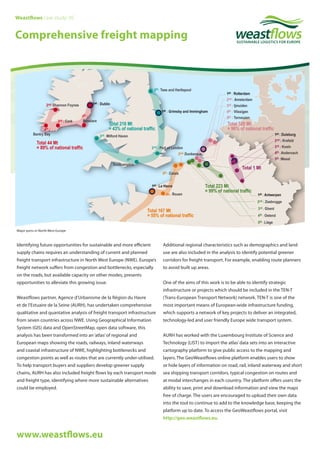
- 1. Identifying future opportunities for sustainable and more efficient supply chains requires an understanding of current and planned freight transport infrastructure in North West Europe (NWE). Europe’s freight network suffers from congestion and bottlenecks, especially on the roads, but available capacity on other modes, presents opportunities to alleviate this growing issue. Weastflows partner, Agence d’Urbanisme de la Région du Havre et de l’Estuaire de la Seine (AURH), has undertaken comprehensive qualitative and quantative analysis of freight transport infrastructure from seven countries across NWE. Using Geographical Information System (GIS) data and OpenStreetMap, open data software, this analysis has been transformed into an‘atlas’of regional and European maps showing the roads, railways, inland waterways and coastal infrastructure of NWE, highlighting bottlenecks and congestion points as well as routes that are currently under-utilised. To help transport buyers and suppliers develop greener supply chains, AURH has also included freight flows by each transport mode and freight type, identifying where more sustainable alternatives could be employed. Additional regional characteristics such as demographics and land use are also included in the analysis to identify potential greener corridors for freight transport. For example, enabling route planners to avoid built up areas. One of the aims of this work is to be able to identify strategic infrastructure or projects which should be included in the TEN-T (Trans-European Transport Network) network. TEN-T is one of the most important means of European-wide infrastructure funding, which supports a network of key projects to deliver an integrated, technology-led and user friendly Europe wide transport system. AURH has worked with the Luxembourg Institute of Science and Technology (LIST) to import the atlas’data sets into an interactive cartography platform to give public access to the mapping and layers. The GeoWeastflows online platform enables users to show or hide layers of information on road, rail, inland waterway and short sea shipping transport corridors, typical congestion on routes and at modal interchanges in each country. The platform offers users the ability to save, print and download information and view the maps free of charge. The users are encouraged to upload their own data into the tool to continue to add to the knowledge base, keeping the platform up to date. To access the GeoWeastflows portal, visit http://geo.weastflows.eu. Major ports in North West Europe www.weastflows.eu Weastflows case study: 05 Comprehensive freight mapping
- 2. Transnational engagement Transnational and close collaboration between partners has been a crucial element in ensuring the success and relevance of the logistics data in this analysis. Weastflows partners provided logistics data from seven countries, supported by the freight network knowledge emerging from the wider project, at every stage. Results and benefits The new European Union policy for transport infrastructure, made public in October 2013, lists priorities that the Weastflows project shares as goals, including the development of intermodal connections, the reduction of traffic congestion, bottlenecks and greenhouse gas emissions. Knowing the characteristics, strengths and weaknesses of NWE freight routes helps logistics and freight operators maximise the use of existing infrastructure capacity and identify alternative transport solutions. Goods can be transported more efficiently and sustainably through more integrated multi-modal options, which ultimately helps reduce transport costs, the environmental impact and congestion. Feedback from organisations using the analysis to date has been positive. Private stakeholders have said this helps them incorporate more sustainable modes of transport into their logistics activities. They also felt it was important to be able to contribute their own data to help keep the analysis up to date. Lessons and recommendations Currently there isn’t a standardised open source database of European transport logistics information. This activity highlighted the importance of using open source data and sharing common data across NWE to encourage the build of a common vision and inter-operability. The project is using the atlas and analysis to inform policy recommendations and influence investment and infrastructure improvements at both regional and EU level. These recommendations, along with information on over and under-used routes and infrastructure, will be compiled into a report, which will be published soon detailing potential solutions to improve the region’s freight capacity. To access this report and the range of analysis developed through this activity, visit www.weastflows.eu. By the end of 2014, the Geoweastflows platform was accessed in 17 countries by 287 users. Given the success of the platform, AURH and LIST will continue its development by populating it with more data and promoting it to industry representatives. Transport corridors across Europe Concentration levels of railways in North West Europe For further information, please contact: Institute for Sustainability 49-51 East Road, London N1 6AH, UK T: +44 (0) 20 7517 1830 E: info@instituteforsustainability.org.uk www.weastflows.eu Weastflows (west and east freight flows) – an INTERREG IVB North West Europe (NWE) project funded by the European Regional Development Fund (ERDF) – aimed to improve and enhance freight logistics across a west-east axis in the NWE region. The project brought together experts from all sectors of the freight transport industry to work towards connecting supply chains in the region with the wider freight network across the rest of Europe and Asia. Through a combination of freight mapping, innovative technology and a drive to promote sustainable logistics, Weastflows has worked to generate a step-change in the industry. This helps deliver economic, social and environmental benefits to both communities and businesses across the region. Lead partners • CRITT Transport et Logistique (FR) • Institute for Sustainability (UK) Partners • Agence d’Urbanisme de la Région du Havre et de l’Estuaire de la Seine (AURH) (FR) • Beter Bereikbaar Zuidoost-Brabant (BBZOB) (NL) • Brabantse Ontwikkelings Maatschappij (BOM) (NL) • Centre for Quantitative Methods (CQM) (NL) • Communication and Tracking Services (CTS) (FR) • InforIT (NL) • Institut du Droit International des Transports (IDIT) (FR) • Intermodality (UK) • Irish Exporters Association (IEA) (IE) • Limerick City and County Council (LCCC) (IE) • Liverpool John Moores University (LOOM) (UK) • Logistique Seine-Normandie (LSN) (FR) • Luxembourg Institute of Science and Technology (LIST) (LU) • Mobycon (NL) • Portsmouth International Port (UK) • South East Scotland Transport Partnership (SEStran) (UK) • Transports Terrestres Promotion Northern France (i-Trans) (FR) • Universität Duisburg-Essen (UNI-DUE) (DE) • University of Science and Technology of Lille (USTL-LAGIS) (FR) • Verband Region Rhein-Neckar (VRRN) (DE) Comprehensive freight mapping