Chapter physical regions of pakistan
•Als PPTX, PDF herunterladen•
0 gefällt mir•1,569 views

for students

Empfohlen
Weitere ähnliche Inhalte
Was ist angesagt?
Was ist angesagt? (20)
Ähnlich wie Chapter physical regions of pakistan
Ähnlich wie Chapter physical regions of pakistan (20)
Mehr von Usman Public School System
Mehr von Usman Public School System (20)
Kürzlich hochgeladen
Kürzlich hochgeladen (20)
Chapter physical regions of pakistan
- 2. Different areas of the Earth resembling each other with reference to their surface, climate, agricultural production and living standard of people are geographically know as regions.
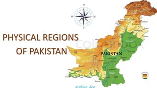
- 3. The important Physical Regions of Pakistan Pakistan is divided into five parts of regions in accordance with different surface features and climatic conditions. 1.Mountain Ranges 2.Pothwar and Balochistan Plateau 3.Indus plain 4.Deserts 5.Coastal Areas
- 4. Mountain Ranges The area mentioned on the map of page 11 is coloured in the dark brown showing the north and north western mountains of Pakistan. A range of high mountains known as the Himalaya Mountains spreads over the North of Pakistan. In the north and north-west of it the Karakoram and Hindu Kush Mountains are located.
- 5. In Northern areas of Pakistan, the Karakorum Mountains are stretched up to Ladakh and Gilgit. These are very high mountains. The top of these mountains are covered with snow during the summers even. The second highest peak in the world, K-2, is located in these mountains.
- 6. The Gilgit valley is located in the Karakoram Mountains. December, January and February are the coldest months. With the help of neighboring country China, Pakistan has constructed a road in these high mountains known as “Karakoram Highway” or “Silk Road”. The trade between Pakistan and China is increasing due to this highway.
- 7. Murree and Hazara hills are located in the south of Northern hills. The beautiful hill stations of Murree, Abbottabad, Nathiagali, Ayubia, Kaghan, Swat and Chitral are located in these hills. These areas provide tourism opportunities to the people coming from all over the country. The western branches are comprised of Koh-i-Suleman and koh-i-Kirthar.
- 8. The hills of Koh-i-Suleman are totally barren. Due to every small amount of rain, the trees are not found here. However, shrubs and thorny bushes are naturally grown that provide fodder for the livestock.
- 9. In the south of Koh-i-Suleman, the koh-i-Kirthar is stretched which separates Balochistan from the Sindh. In order to cross the Koh-i-Suleman, there are many natural paths which are known as passes. The famous passes of these areas include Tochi, Goal and Bolan. In this area, trade is possible through these passes only.
- 10. Plateaus In Pakistan there are only two plateaus: I. Pothwar plateaus. II.Baluchistan plateaus.
- 11. Potohar Plateaus The Pothwar plateaus is located in between river Jhelum and Indus. The Northern part of this plateaus includes the districts of Jhelum, Chakwal, Rawalpindi and Attock. The surface of Pothwar is cut apart due to temporary small streams and rainfalls.
- 12. The surface of Potohar plateaus is soft as well as rocky. The small hills are also found here, so the surface is not suitable for crop cultivation. However, mineral oil, gas, salt and other types of minerals are found here.
- 13. The kohistan-i-Namak is located in the south of Potohar plateau. It starts from western bank of river Jhelum and is stretched to district Bannu of Khyber Pakhtunkhwa. These are low hills and consist of Jhelum, khushab Mianwali districts. The second biggest salt mine in the world is located in his mountain range known as “Khewra salt mine”.
- 14. Baluchistan plateau Baluchistan plateau is located in the west of Koh-i-Suleman and koh-i-Kirthar. The surface of this plateau is stony and sandy. This range of barren hills is stretched from North East to South West. This area is very important for minerals and from here copper, potassium, natural gas and coal are being extracted.
- 15. In the middle of this plateau, there is a salt lake in which a few streams and nullahs fall. The climate of this region is dry and hot in the summers and dry and cold in winters. Rainfall is a rare phenomenon in this area. However, where water is available the fruit farming is done. The water of springs is supplied to the orchards and farms through karez (covered water channel) system. In this area, Ziarat in the famous health resort of this area.
- 16. Indus plain The vast Indus plain can be divided into two parts: I. Upper Indus plain II.Lower Indus plain
- 17. Upper Indus plain The Indus plain starts from the eastern border of Pakistan towards the Koh-i-Suleman in the west and is stretched to district Bahawalpur in the south. The whole area is irrigated by river Indus, Jhelum, Chenab, Ravi and Sutlej. It is almost a flat plain. This plain is formatted by the fertile soil of rivers. In the Eastern areas of Punjab, the annual rainfall rate is low that is not sufficient for the crop cultivation. However, the shortage of rainfall is fulfilled by the construction of canals from these rivers. One of the best canal networks of the world is found in the Indus plain.
- 18. Lower Indus Plain The southern part of Punjab and most part of Sindh is called lower Indus Plain. This part is also flat. The lower Indus plain is irrigated by River Indus. The northern part is comparatively higher than the southern part. Several canals have been constructed on the river Indus near Guddu, Sukkar and Kotri areas.
- 19. Lower Indus plain is also made up of soft and fertile soil, but due to limited rainfall the land remained uncultivated for long time and forced the local population to live us gypsies.
- 20. Coastal Areas Sindh and Baluchistan form the costal line of the Arabian Sea. The Coastal plain is located on the shore of Arabian Sea. The coastal area of Pakistan is about 1000km long and comprises of important Sea ports such as Karachi, bin Qasim and Gawadar. Most of the people of coastal areas earn their living through fishing.
- 21. Physical Regions of Pakistan and life of people
- 22. In plain areas, the summer and winter seasons are at their extreme. Major profession is agriculture. People eat and dress according to the season. These are thickly populated areas.
- 23. The summers are extremely hot in desert areas. During day time, often hot wind blows and the rainfall is scanty. In these areas, people earn their living by breeding animals.
- 24. In mountainous regions, winter season is very cold and usually snowfall takes place. The people living in hot places visit hill stations because of the cold climate. The people of these areas are employed in professions like mining, livestock, and hotel and tourism services. These areas are also famous for different types of fruits for example, grapes, apple and pear etc. These areas are full of mineral resources.
- 25. Interdependence
- 26. Interdependence means people are dependent on one another to fulfill their needs. It is said that man is a social animal and he has to rely on others for his needs. Man’s social life is due to his interdependence. In a society people are associated to various occupations like, growing grains, knitting clothes, trading and industry. They all dependent on one another.
- 27. Similarly, in our country, people have various occupations and are dependent on one another. In the world, some countries are self-sufficient in minerals resources like oil, gas and agricultural products. This uneven distribution of resources is the cause of interdependence.