High Resolution Aerial Images Services
•
7 gefällt mir•1,126 views

Geo Sense aerial photo services using UAV for urban and project monitoring.

Empfohlen
Empfohlen
Weitere ähnliche Inhalte
Andere mochten auch
Andere mochten auch (13)
Ähnlich wie High Resolution Aerial Images Services
Ähnlich wie High Resolution Aerial Images Services (20)
Mehr von Ismail Ibrahim
Kürzlich hochgeladen
Kürzlich hochgeladen (20)
High Resolution Aerial Images Services
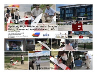
- 1. Updating High Resolution Aerial Images Using Unmanned Aerial Vehicle (UAV) Geo Sense Sdn. Bhd. 19B Medan Aliff Harmoni 1/2, Taman Damansara Alif 81200, Johor Bahru, Johor, Malaysia 0197266411 www.geosense.info
- 2. Iskandar Malaysia – Approx 2,200 sq km Current high interest areas – Approx 200 sq km Visually, what do we know about our area, except some boundaries data and images from space Nusajaya Authorities need high resolution aerial images to make better, accurate and faster decisions.
- 3. Satellite - traditional source of aerial images -Outdated -Inaccurate & -Low resolution Geo Sense Sdn. Bhd.
- 4. Eg. Danga Bay Area Satellite images – subject to cloud cover Unreliable images delivery Geo Sense Sdn. Bhd.
- 5. Alternately… photo from small aircraft or helicopter Sample of aerial photo from aircraft - Larger coverage advantage - Lack of availability (lack of dedicated & professional services) - Limited coverage due to flight regulation (etc) - Costly Geo Sense Sdn. Bhd.
- 8. UAV Quality Images Danga Bay
- 10. Comparing satellite/google images with UAV UAV : 10 cm res per pixel Satellite : >1 meter res
- 11. Existing Google Image - Two years old image of Danga Bay commercial complex Patching images of high interest area with UAV Result - latest high resolution aerial images Geo Sense Sdn. Bhd.
- 12. Sample of imagery – up to 7 cm resolution per pixel Geo Sense Sdn. Bhd.
- 13. Sample Danga Bay High Resolution Aerial Images Patch with UAV Images Satellite Images UAV Images Geo Sense Sdn. Bhd.
- 14. Image Clarity help in monitoring ground activities Property under renovation Geo Sense Sdn. Bhd.
- 15. Sample Application: Detecting illegal hawker (enforcement)
- 16. Integration GIS / Boundaries Info Lot 12333 Lot 15621 Future Lot 25621 Development Ref Lot 112122 Lot 76575 Lot 34243 Application Development Future Ref Lot 112122 Development Future Ref Lot 112122 Development Ref Lot 112122
- 17. Urban micro planning & monitoring Iskandar Malaysia / Johor State Gov. Geo Sense Sdn. Bhd.
- 19. Geo Sense Sdn. Bhd.
- 20. Urban planning & monitoring Johor New Admin Center Nusajaya
- 21. Individual Images taken from UAV are stitched for larger images Overlapping from 15% to 80% 200 m 250 m 400 meters 1,200 meters Geo Sense Sdn. Bhd
- 22. Johor New Admin Center Nusajaya – patch to satellite image
- 23. Proposal UAV for Aerial Applications – Multi purpose Monitoring natural disaster Setting up Johor State Government / Iskandar Malaysia Operation center based on high resolution aerial images Flood Centralize Monitoring Room Landslide Forest & River monitoring (environmental protection) Updating Gov. / IRDA Crowd monitoring GIS / Mapping system
- 24. Online High Resolution Images Monitoring System N S
- 25. Existing UAV System – Micro glider Future Investment – Mid Range UAV based UAV (covering 0.5 – 1 sq km per (covering > 1 km per mission with more mission) than 1 hour flight time)
- 26. Geo Sense Sdn. Bhd. Location Information Service Providers 19B Medan Aliff Harmoni 1 / 2, Taman Damansara Alif 81200, Johor Bahru, Johor, Malaysia Tel 607-2341919 Fax 607 2344848 Mobile: 60197266411 www.geosense.info ismaili@geosense.info Innovation Geo Prof. Dr. Ayob bin Sharif. information and Web Advisor, 57, B. Sc. (Hons.) Land Surv. Sc. (C.N.A.A., UK), M. Surv. Sc. (UNSW, Australia.), GIS software Ph.D (Newcastle Upon Tyne, UK), FISM, License company. Surveyor (LJT) Geo Sense provides comprehensive geo Ismail Ibrahim, CEO 39, 15 years in e-Gov, IT project dev and information data as a management. Previously CEO of M-Apps web delivery services. Solution, specializing in mobile & wireless tech. Bsc (Info Sys), Michigan, USA, MBA VC Cranfield UK Other Services • Spatial data planning, Mohd Azman Mohd Noor gathering, COO, 36, 12 years in computer engineering, development and mapping and GIS related development, Bsc updating Electronic and Comp. Engineering, UPM, Malaysia • GPS-GSM Tracking system . • Web GIS integration • Aerial photo services Finalist MSC Asia Pacific ICT Award 2008