Chris Harrison Internet Map City To City Connections
1. Chris Harrison - Internet Map: City-to-City Connections 22/09/2008 15:25
The Dimes Project provides several excellent data sets that describe the structure of the Internet. Using their most recent data at
the time (Feb 2007), I created a set of visualizations that display how cities across the globe are interconnected (by router
configuration and not physical backbone). In total, there are 89,344 connections.
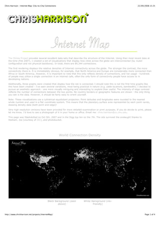
The first rendering displays the relative densities of Internet connectivity across the globe. The stronger the contrast, the more
connectivity there is. It is immediately obvious, for example, that North America and Europe are considerably more connected than
Africa or South America. However, it is important to note that this only reflects density of connections, and not usage - hundreds
of people may utilize a single connection in an internet cafe, often the only form of connectivity people have access to in
developing nations.
Additionally, three graphs were created that display how the net is connected. I should note this is not the first time graphs like
this have been created - I've seen several variations, most being practical in nature (e.g. cable locations, bandwidth). I decided to
pursue an aesthetic approach - one more visually intriguing and interesting to explore than useful. The intensity of edge contrast
reflects the number of connections between the two points. No country borders or geographic features are shown - the only thing
you see is the data. However, it should be fairly easy to orient yourself.
Note: These visualizations use a cylindrical equidistant projection. Point latitudes and longitudes were rounded to the nearest
whole number and used in a flat coordinate system. This means that the planetary surface area represented by each point varies,
skewing density data (both point and edge)!
Very high resolution versions have been provided for more detailed examination or print purposes. If you do decide to print, please
let me know. I'd love to see a photograph of it in your home or office. Email me: chris.harrison@cs.cmu.edu.
This page was Slashdotted on Oct 5th, 2007 and in the Digg top ten on the 7th. The site survived the onslaught thanks to
Hesham, Joe (courtesy of ISC), and photobucket.
World Connection Density
Black Background (seen White Background (ink-
above) friendly)
http://www.chrisharrison.net/projects/InternetMap/ Page 1 of 4
2. Chris Harrison - Internet Map: City-to-City Connections 22/09/2008 15:25
Medium Resolution JPG Medium Resolution JPG
High Resolution PNG High Resolution PNG
World City-to-City Connections
Black Background (seen White Background (ink-
above) friendly)
Medium Resolution JPG Medium Resolution JPG
High Resolution PNG High Resolution PNG
European City-to-City Connections
http://www.chrisharrison.net/projects/InternetMap/ Page 2 of 4
3. Chris Harrison - Internet Map: City-to-City Connections 22/09/2008 15:25
Black Background (seen White Background (ink-
above) friendly)
Medium Resolution JPG Medium Resolution JPG
High Resolution PNG High Resolution PNG
North American City-to-City Connections
http://www.chrisharrison.net/projects/InternetMap/ Page 3 of 4