
Empfohlen
Weitere ähnliche Inhalte
Was ist angesagt?
Was ist angesagt? (19)
Andere mochten auch
Andere mochten auch (20)
Ähnlich wie Venezuela is part of South America. Data on South American geography
Ähnlich wie Venezuela is part of South America. Data on South American geography (20)
Mehr von VenezuelanTourism
Mehr von VenezuelanTourism (10)
Kürzlich hochgeladen
Kürzlich hochgeladen (20)
Venezuela is part of South America. Data on South American geography
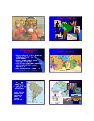
- 1. World Regional Geography SOUTH AMERICA David Sallee Lesson 6 MAJOR GEOGRAPHIC QUALITIES PLATE TECTONICS PHYSIOGRAPHY IS DOMINATED BY THE ANDES MOUNTAINS S AND THE AMAZON BASIN. POPULATION IS CONCENTRATED ALONG THE PERIPHERY. CULTURAL PLURALISM EXISTS IN MOST COUNTRIES AND IS EXPRESSED REGIONALLY. REGIONAL ECONOMIC INTERACTION HAS BEEN MINIMAL IN THE PAST. SOUTH AMERICA: PRECIPITATION CONTINENT OF EXTREMES • PRECIPITATION • TEMPERATURE • VEGETATION • ELEVATION • INCOME • POPULATION 1
- 2. VEGETATION TEMPERATURE • It is over 7,000 km (4,400 miles) long, 500 km (300 miles) wide in some parts and of an average height of about 4,000 m (13,000 feet). ELEVATION • Highest mountain range outside Asia, with the highest peak, Aconcagua, rising to 6,962 m (22,841 feet) above sea level. • Cannot match the Himalaya in height but do so in width and are more than twice as long. POPULATION • • • • • • A HOLLOW CONTINENT - WHY? PHYSIOGRAPHIC BARRIERS NON-COMPLEMENTARY NONECONOMIES LACK OF DEVELOPED INFRASTRUCTURE INDIVIDUAL COUNTRIES ORIENTED TOWARDS EUROPE AND THE US – NOT TOWARDS EACH OTHER 78% - URBANIZED CONTINENT-WIDE IN CONTINENTSOUTH AMERICA • South America has a shoreline length of 144,566.8 miles including beaches, mangrove swamps, and rocky cliffs. INCOME Brazil (example) •Largest income gap in the realm •Wealthiest 10% of the population own 2/3 of the land and control over 50% of the country’s wealth THE INCA EMPIRE CULTURE HEARTHINTERMONTANE BASIN AROUND CUZCO (1200-1535 A.D.) ALTIPLANOS WERE KEY TO SETTLEMENT PATTERNS. 20 MILLION SUBJECTS AT ITS ZENITH TRANSPORTATION NETWORKS AND INTEGRATION EFFORTS WERE Pachacuti-IncaPachacuti- IncaMOST IMPRESSIVE. Yupanqui – 9th ruler of the Inca Empire A HIGHLY CENTRALIZED STATE 2
- 3. THE INCA EMPIRE Inca Masonry Inca Crafts Inca Roads The Inca road system covered approximately 22,530 km (14,000 mi) and provided access to over three million km² of territory. km² Inca Mysteries INDIGENOUS PEOPLES & COLONIAL DOMAINS 3
- 4. The Huaorani The Huaorani people are a people shrouded in mystery. They speak a language unrelated to any other (in fact it has yet to be even classified). Additionally, their pottery designs do not resemble those of their past or present neighbors. It is only known through their own folklore that they migrated from "down river" a long time ago, "fleeing the cannibals." Chief Kem Pery and his wife They revere the jaguar and call themselves, Huaorani which means "human beings" or "the people," and refer to everyone else as cowode or "non-humans." Up until four decades ago the "nonHuaorani still used stone axes and maintained a thoroughly traditional hunter and gather lifestyle in their extremely isolated and monkey-rich rainforest monkeyhaven. Hunting for monkeys with a traditional blowgun and poisonous darts However, in the 1950's all of this changed. First the missionaries came. Then concomitant with the global demand for oil came the demand to find new oil reserves, and as fate has it the world's 1,200 Huaorani live right on top of one of Ecuador's biggest oil deposits. Since this discovery, the Huaorani have been forced to deal Son's first machete lesson with the encroachment of oil companies and cowode on the land they have called home for at least a millennia. SOUTH AMERICA’S AMERICA’ CULTURE SPHERES However, like indigenous people all over the world who learn that they have natural resources other nations want, they are forced by those who make the rules to adapt as best they can to changing realities. One Huaorani clan, the Tagaeri, has moved deeper in the Tagaeri, forest to shun all contact with the outside world. Other Huaorani communities have adopted ecotourism as a way to maintain control over their land, culture and resources. Huorani family in their hammock CULTURE SPHERES Tropical-plantation Resembles Middle America’s Rimland Locations, soils, & tropical climates favor plantation crops, especially sugar. Initially relied on African slave labor 4
- 5. CULTURE SPHERES European-commercial CULTURE SPHERES Amerind-subsistence The most “Latin” part of South America Includes the Pampas temperate grasslands Economically most advanced Transportation networks and quality of life are excellent. Correlates with the former Inca Empire Feudal socioeconomic structure persists Includes some of South America’s poorest areas Subsistence agriculture must contend with difficult environmental challenges. CULTURE SPHERES CULTURE SPHERES Mestizo-transitional Surrounds the Amerindiansubsistence region A zone of mixtureculturally & agriculturally Transitional -economic connotations Undifferentiated Characteristics are difficult to classify. Sparsely populated Isolation and lack of change- notable features Development of Amazonia may prompt significant changes. BARRIERS TO INTEGRATION A HOLLOW CONTINENT - WHY? PHYSIOGRAPHIC BARRIERS NON-COMPLEMENTARY ECONOMIES LACK OF DEVELOPED INFRASTRUCTURE INDIVIDUAL COUNTRIES ORIENTED TOWARDS EUROPE AND THE US – NOT TOWARDS EACH OTHER POLITICAL MAP 5
- 6. URBANIZATION 80 70 World N. America Europe Russia M & S America Asia Africa 60 Percentage THE MOVEMENT TO AND CLUSTERING OF PEOPLE IN TOWNS AND CITIES THE PERCENTAGE OF A COUNTRY’S COUNTRY’ POPULATION LIVING IN CITIES 78% - CONTINENT-WIDE IN SOUTH CONTINENTAMERICA SOUTH AMERICA’S INCREASE BASED AMERICA’ ON RATE OF “NATURAL INCREASE” AND INCREASE” INTERNAL MIGRATION GLOBAL URBANIZATION 50 40 30 20 10 0 1950 1960 1970 1980 1990 2000 Urban Population as a Percentage of Total Population in Different Areas of the World, 1950-2000 REGIONS OF THE REALM Caribbean North Colombia Venezuela Guyana Suriname French Guiana Brazil BRAZIL South America’s Giant World rankings Population size - 5th Andean West Peru Ecuador Bolivia Territory - 5th Southern Cone Argentina Chile Uruguay Paraguay BRAZIL CONTAINS HALF THE CONTINENT’S LAND CONTINENT’ AND PEOPLE A FEDERAL REPUBLIC OF 26 STATES ETHNIC DIVERSITY - MIXTURE OF EUROPEAN, AFRICAN, AND AMERINDIAN PEOPLES PORTUGUESE - SPEAKING & ROMAN CATHOLIC ADHERENTS SUBSTANTIAL MINERAL RESOURCES: IRON, ALUMINUM ORE, MANGANESE, OIL, AND GAS Economy - 8th Industrial base - 8th A Two Class System? GNP per capita-$4,630 Largest income gap in the realm Wealthiest 10% of the population... own 2/3 of the land control over 50% of the country’s wealth Poverty has increased by 50% since 1980 6
- 7. BRAZIL GREAT CITIES RIO DE JANEIRO – CULTURAL FOCUS SAO PAULO - INDUSTRIAL BRASILIA - A “FORWARD CAPITAL” CAPITAL” DEVELOPING THE AMAZON “GROWTH POLE” CONCEPT POLE” ENVIRONMENTAL CONCERNS GROWTH POLE THEORY AIMS TO PROMOTE GROWTH IN THE HINTERLANDS AUGMENTED BY INVESTMENT SUPPORT IN AN ATTEMPT TO SPREAD ECONOMIC ACTIVITIES AND BENEFITS CREATE JOBS IN DEPRESSED AREAS REDUCE UNEVEN CONCENTRATIONS OF WEALTH DECENTRALIZE INDUSTRY SETS OFF “RIPPLES” OF DEVELOPMENT FORWARD CAPITAL CAPITAL CITY POSITIONED IN A CONTESTED OR POTENTIALLY CONTESTED TERRITORY USUALLY NEAR AN INTERNATIONAL BORDER CONFIRMS THE STATE’S DETERMINATION TO MAINTAIN ITS PRESENCE IN THE TERRITORY UNDER CONTENTION ST PETERSBURG, RUSSIA ISLAMABAD, PAKISTAN BRASILIA, BRAZIL (INTERNAL FRONTIER – “GROWTH POLE CONCEPT”) THE NORTH (CARIBBEAN SOUTH AMERICA) VENEZUELA, COLOMBIA, GUYANA, SURINAME, FRENCH GUIANA REGIONAL CHARACTER: COASTAL LOCATIONS, EARLY EUROPEAN PLANTATION DEVELOPMENT, FORCED MIGRATION OF BLACK LABORERS VENEZUELA - 25.2 MILLION PEOPLE OIL FROM LAKE MARACAIBO IS CHIEF RESOURCE CARACUS & VALENCIA - KEY CITIES CARIBBEAN SOUTH AMERICA COLOMBIA - 41.6 MILLION PEOPLE COFFEE, OIL & COAL - MAJOR EXPORTS COCAINE - LEADING ECONOMIC ACTIVITY TORN BY INTERNAL VIOLENCE BOGOTA & MEDELLIN - KEY CITIES THE GUIANAS (FRENCH GUIANA, GUYANA, SURINAME) POPULATIONS< 1.5 MILLION ETHNICALLY DIVERSE POVERTY STRICKEN FACE ENVIRONMENTAL CRISIS THE NORTH (CARIBBEAN SOUTH AMERICA) 7
- 8. THE WEST (ANDEAN SOUTH AMERICA) PERU, ECUADOR, BOLIVIA REGIONAL CHARACTER: AMERINDIAN POPULATIONS, SUBSISTENCE AGRICULTURE, MOUNTAINOUS ENVIRONMENTS, POVERTY PERU - 28.3 MILLION PEOPLE LIMA IS ITS PRIMATE CITY ECONOMIC ACTIVITIES - FISHING, IRRIGATED AGRICULTURE, SUGAR, COTTON, RICE, FRUIT, OIL, MINERALS (AN EMERGING ECONOMY!) ANDEAN SOUTH AMERICA ECUADOR - 13.1 MILLION PEOPLE MAIN EXPORTS: OIL, COFFEE, CACAO, BANANAS GUAYAQUIL - LARGEST CITY AND COMMERCIAL CENTER QUITO - CAPITAL AND ADMINISTRATIVE CENTER BOLIVIA - 8.6 MILLION PEOPLE (DISPERSED) LANDLOCKED MAIN EXPORTS: TIN AND ZINC THE SOUTH (MID-LATITUDE SOUTH AMERICA) (MIDTHE WEST (ANDEAN SOUTH AMERICA) THE SOUTHERN CONE: ARGENTINA, CHILE, PARAGUAY, URUGUAY HEART OF EUROPEAN-COMMERCIAL CULTURE SPHERE ARGENTINA - 37.8 MILLION PEOPLE 90% URBANIZED, PERIPHERAL BUENOS AIRES (12.9 MILLION) - A CLASSIC PRIMATE CITY EXPORTS: CEREALS, MEATS, VEGETABLE OILS THE SOUTH: MID-LATITUDE SOUTH AMERICA MID- THE SOUTH (SOUTHERN CONE) URUGUAY - 3.3 MILLION MONTEVIDEO - CLASSIC PRIMATE CITY MOST EUROPEAN OF SOUTH AMERICAN COUNTRIES EXPORTS: HIDES, MEATS,TEXTILES PARAGUAY - 5.8 MILLION 95% MESTIZO LANDLOCKED LOCATION CHILE- AN “ELONGATED STATE” EXPORTS: COPPER AND NITRATES 8
- 9. CULTURAL ASSESSMENT BRAZIL – Children are treated affectionately, and kissing a child is preceded by inhaling (smelling). - The attitude of the Father may be the most significant factor in breastfeeding. - The finger sign for OK in the U.S. is a crude sexual invitation in Brazil. CHILE – Many believe that a woman should have as many children as God gives her. COLOMBIA – Illness may be caused by punishment from God for transgressions. - The Father usually determines whether a pregnancy is terminated or not. PARAQUAY – Close friends of both sexes may walk arm-inarm. 9