Sandcastles for Science

Internal Presentation to the Center of Interdisciplinary Science for Art, Architecture, and Archaeology (CISA3) at the University of California, San Diego's Qualcomm Institute branch of the California Institute of Telecommunications and Information Technology (Calit2). Sandcastles for Science resulted in the IEEE publication by David Srour, Ashley M. Richter, Thomas E. Levy, and Falko Kuester "Temporal Terrestrial Laser Scanning to Visualize the Archaeological Process." Abstract: Archaeology is a destructive science. Photographs and videos preserve some aspects of the sequence of events inherent within the archaeological excavation process, but cannot replicate the spatiality and detail of the downward progression of the digging entailed through excavation. Time lapse sequences of properly adapted and employed terrestrial laser scanning to create a temporal sequence of point clouds of the archaeological methodologies can, however, serve as an innovative step towards accurate documentation of crucial data for future archaeologists interested in the site. Over the course of the National Science Foundation Integrative Graduate Education and Research Traineeship funded Sediment Intervals and Site Deformation Processes: Exploring Time Lapse Laser Scanning Capabilities and Methodologies for Archaeology, temporal scanning was tested on the beaches of San Diego to establish a baseline capability for data capture. Subsequently, the methodologies for data collection were utilized as a part of the excavation workflow at the University of California, San Diego’s Edom Lowlands Regional Archaeological Project’s excavation of a Roman era section of tell Khirbat Faynan in southern Jordan. With the data collected from the excavation as the impetus for new system development, original visualization processing designed with the archaeological problems and end-goals in mind is being created at the University of California, San Diego Center of Interdisciplinary Science for Art, Architecture, and Archaeology in order to meaningful display the shifting data sets in real time and exhibit not just the archaeological data, but the archaeological process.

Empfohlen
Empfohlen
Weitere ähnliche Inhalte
Mehr von Ashley M. Richter
Mehr von Ashley M. Richter (12)
Kürzlich hochgeladen
Kürzlich hochgeladen (20)
Sandcastles for Science
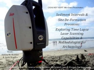
- 1. CISA3 NSF IGERT Mini-Grant Presentation Sediment Intervals & Site De-Formation Processes: Exploring Time Lapse Laser Scanning Capabilities & Methodologies for Archaeology Team: Ashley M. Richter & Leah Trujillo With Partipcation By: Jessica Linback, Claire McConnell, James Morgan Darling, Jason
- 2. Project Goals: •Investigate the Potential of Terrestrial Laser Scanning under Field Constraints to Capture Site Stratigraphy • (i.e. sediment changes Archaeologists <3 Stratigraphy) •Actual Resolution of Scanner & its Photography System •Ability to identify movement of granular particles •Investigate the Possibility of Temporal Scanning •Practicalities of capturing multiple data sets of same space in the field under time constraints •Temporal data organization •Education Outreach Potential •Ways to engage public in tech while still collecting data •Gauge Levels of Interest in our activities •CISA3 Bonding ;)
- 3. Experiment #1: Footsteps in the Sand A Raked smooth sand-space is scanned repeatedly with additional footprints added in between each scan. = Investigation of Scanner’s Point & Photographic Clarity in Visualizing Indeterminate Granular Matter & Dealing with Visual Tracking of Changes
- 4. Results of Experiment #1: Footsteps in the Sand *Point cloud sufficiently tracks physical change (though could be better) -BUT scanner’s photography does NOT Conclusion: All field scanning should be accompanied with high resolution field photography of same space ( =additional Structure from Motion possibilities) *Proprietary Software ill equipped to handle comprehensive visualization navigating between temporal point clouds Conclusion: We need to develop a system to do this (= a fun project for Dave & Vid)
- 5. Experiment #2: Long Term Sediment at Faux-Site Goals: Long term tracking of sediment transformation using temporal scanning methods as we create them Failure: Site chosen, shovel acquired, never built: time constraints & beach access issues Plan: Build small rock structure on beach in deep depression, track its natural erosion throughout spring & summer
- 6. Experiment #3: Sandcastles for Science Capturing High transitioning res detail Plan: Build Sandcastles, Scan, Etch additional fine detail into sandcastle, scan, smash sandcastle, scan Goals: Can terrestrial laser scanning capture fine detail transformation? Further temporal tracking… Conclusion: No- additional tech required to collect fine visible and physical changes to s space
- 8. Experiment #3: Sandcastles for Science Education Outreach THANK YOU TO EVERYONE WHO PARTICIPATED!
- 9. *Practical Temporal Scanning Methodology Created *Need for additional Diagnostic Imaging to compliment the scanning specified Basic Conclusions
- 10. Next week: Pulling in new equipment to compliment capabilities of terrestrial laser scanner