City of ashland an analysis of mobile gis through amazon elastic cloud comp...
Airphoto anomilies
1. Airphoto Anomalies
Views of Wisconsin from the Air
Thanks to East Central, Bay Lake, and Dane County Regional Planning Commissions
210 McClellan St., Suite 210, Wausau, WI 54403
715-849-5510 - staff@ncwrpc.org - www.ncwrpc.org
Prepared By:
North Central
Wisconsin Regional
Planning CommissionNCWRPC
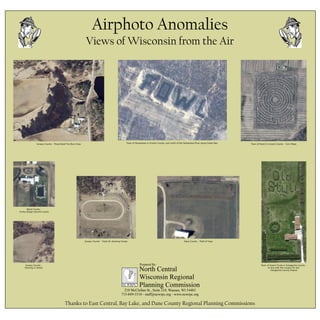
Juneau County - Prescribied Fire Burn Area Town of Pensaukee in Oconto County, just north of the Pensaukee River along Green Bay. Town of Scott in Lincoln County - Corn Maze
Wood County -
Funky design around a pond
Town of Grand Chute in Outagamie County -
In line with the runway for the
Outagamie County Airport
Juneau County -
Farming in Action
Juneau County - Track for showing horses Dane County - Field of hops