GPS OVERVIEW
•Download as PPT, PDF•
2 likes•329 views

This presentation based upon implementation of forest right act using GPS .

Recommended
More Related Content
What's hot
What's hot (20)
Viewers also liked
Similar to GPS OVERVIEW
Similar to GPS OVERVIEW (20)
Recently uploaded
Recently uploaded (20)
GPS OVERVIEW
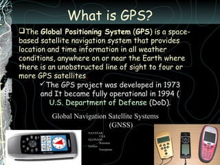
- 1. What is GPS? The Global Positioning System (GPS) is a space- based satellite navigation system that provides location and time information in all weather conditions, anywhere on or near the Earth where there is an unobstructed line of sight to four or more GPS satellites. The GPS project was developed in 1973 and It became fully operational in 1994 ( U.S. Department of Defense (DoD). Global Navigation Satellite Systems (GNSS) NAVSTAR USA GLONASS Russians Galileo Europeans
- 2. How GPS works? At least 3 satellites required for 2D fix
- 3. Three SV ranges known 20,000 Km radius 22,000 Km radius 21,000 Km radius
- 4. Gps vs land survey Surveying or land surveying is the technique, profession, and science of accurately determining the terrestrial or three- dimensional position of points and the distances and angles between them. These points are usually on the surface of the Earth, and they are often used to establish land maps and boundaries for ownership or governmental purposes.
- 5. Present land survey equipments Gps /dgps Total station Theodolite ……
- 6. Compare between gps and plain table
- 7. Gps in forest resource mapping VILLAGE MERKUL, KALAHANDI A CASE STUDY Pre survey required instruments 1. Gps, (rechargeable battery) 2. Different color sketch pen 3. Drawing paper 4. Cadastral map 5. Topo sheet 6. Field note 7. Pen 8. Pencil
- 9. 1.Arrangement of FRC meeting with elder village persons
- 10. 2.Preparation of customary village boundary sketch map
- 12. 3.Gps point taken at field (both triangulation points and customary landmarks
- 13. Record of gps points Signature of FRC members and submission of gps data field note.
- 14. 4. transfer of gps data into gis software using arcgis
- 15. 5.Scanning of cadastral maps & topo sheet 1. Conversion of paper map into digital format for use in gis
- 16. 6. final preparation of village map with customary boundary by using gis software
- 17. 7.boundary on Google earth
- 18. THE END
Editor's Notes
- GPS. AND FOREST RIGHT ACT