City Origin and Growth - Banaras/Varanasi
•
14 gefällt mir•13,002 views

Reading Varanasi's Origin, Growth and Culture with respect to city formation and urban pattern

Empfohlen
Weitere ähnliche Inhalte
Was ist angesagt?
Was ist angesagt? (20)
Andere mochten auch
Ähnlich wie City Origin and Growth - Banaras/Varanasi
Ähnlich wie City Origin and Growth - Banaras/Varanasi (20)
Kürzlich hochgeladen
Kürzlich hochgeladen (20)
City Origin and Growth - Banaras/Varanasi
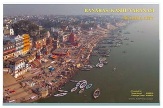
- 1. BANARAS/ KASHI/ VARANASI Presented by: Teena Jaswal 41600016 Gurkirpal Singh 41600020 READING CITY
- 2. INTRODUCTION • The city of Varanasi -“sacred city” of India and it is recognized as the “most ancient continuously living city of the world”. • The city is unique in the architectural, artistic and religious expressions of traditional Indian culture and is, even today a living example of this culture. • As fast as continuity of cultural tradition is concerned banaras surpasses all civilization centers. ACCESS TO THE CITY: By Air: The airport is at Babatpur, 23 km from the city centre and is about 30 km from the ghats. By Rail: Varanasi is linked to all major cities of the country and is the focal point for the Northern and North-Eastern Railways in India. Varanasi Cantt. is the main railway station of the city and is located on the Grand trunk Road. By Road Varanasi is situated at the junction of three national highways -NH2 from Kolkata to Delhi, NH7 to Kanyakumari and NH29 to Gorakhpur and undoubtedly it is one of the busiest roads of India. CLIMATE: The city enjoys sub-tropical monsoon climate. The temperature varying between 5c – 45 c in a year. The relative humidity is high during monsoon reaching up to 82-85%. Annual rainfall in varanasi is around 1000 mm.
- 3. • Holiest of the seven sacred cities in Hinduism • considered as the oldest continuously nhabited city • Archaeologically proven – inhabited by humans since 800 B.C. • Varanasi is developed between two rivers: Varana and Assi- Varanasi • Kaash- Kasi • Bana+ Ras- Banaras River varana River Assi • 86 ghats along the river ganga •In the early medieval period, varanasi passed from one ruler to another and developed the architecture and culture accordingly
- 4. • The city originated with the creation of Manikarnika ghat • Lord Shiva and Parvathi made Vishnu to handover “Kashi” • “Who so ever should have died in Kashi shall reach salvation”- myth in Vedas • Lord Vishnu created pool (Manikarnika Kund) and filled it with his sweat as ordered by Lord Shiva & Goddess Parvati. • The name Mani karnika refers to the jewel of Lord shiva’s ear ring. • The ear ring was studded with a pearl “MUKTA”- so the sacred place “tirtha” should confer “ MUKTI” ORIGIN OF THE CITY (Mythological) Region of settlement & origin (Manikarnika Ghat) Manikarnika Kund Manikarnika Kund & Ghat EARLYHISTORICPERIOD-VEDICPERIOD Source: Singh, R. P. (2009). Banaras: making of India's heritage city. Newcastle: Cambridge Scholars.
- 5. • The five sacred territories are further explained as the symbol of “gross elements” • This is comparable to shiva’s dance symbolising cosmic cycle of creation and destruction as the basis of all existence . • As per the five elements comprising of sky, earth, air, water, fire; creating pilgrimage circuits which developed in the form of garlands, consisting of different number of shrines in chain. • The patterns become base for further development of cosmic order. COSMIC ORDER OF THE CITYEARLYHISTORICPERIOD-VEDICPERIOD Source: Singh, R. P. (2009). Banaras: making of India's heritage city. Newcastle: Cambridge Scholars.
- 6. SETTLEMENT- INITIAL STAGEEARLYHISTORICPERIOD-VEDICPERIOD • The city was developed in the square & circle combination. • The square includes mostly temples and the circle act as the circumambulatory path around the temples • Further the expansion of the city started outside the square towards the panchkrosi route. Source: Singh, R. P. (2009). Banaras: making of India's heritage city. Newcastle: Cambridge Scholars.
- 7. ORIGIN OF THE CITY (Geomorphic) • The concave bank is erosional and the convex bank is depositional in nature. • The concave bank can cave in and cause destruction and the convex bank prograde by continuous deposition preventing easy accessibility to water On such a prominent natural levee of the concave (left) bank of a meander of the river Ganga, is situated Varanasi (Fig. 10.4). • City develop along the concave bank but not along convex bank in spite of fact, that the concave bank is vulnerable to erosion. • On the concave bank, the water of the channel flows touching the lower part of the bank/natural levee, hence water is accessible easily. • On the other hand, the water along the convex bank recedes (away from the settlement after once it is established) along with the progradation of the bank due to continuous depositional process. This is exactly the reason why large habitations develop over the natural levees along the concave bank. Of course, it is a different matter, once after a large habitation develops along a concave bank, if the river channel shifts because of cut-off, the habitations end up on the side of convex banks. That means the early habitations like Varanasi developed along the concave banks with a clear understanding of river channel processes. Source: Raju, K., & Pandey, M. K. (n.d.). 10 Varanasi: origin and Growth from a Geomorphic Perspective. In Varanasi: myths and scientific studies-proceedings of an interdisciplinary workshop (pp. 134-148). New Delhi: Aryan books international.
- 8. • The land of Varanasi is considered to be 'blessed land' because it was quite above normal flood levels. • During floods, when everything else is submerged in flood waters, the natural levee with a relative relief of 5- 7 meters above the lowest level in the flood basin, the surface on which Varanasi has developed, can remain high and dry. • Many local natural depressions were deepened and lined with steps; these ponds served as water source for religious as well as domestic purposes. • Gradually, with the space getting filled by urban elements, these inlets –and outlets got truncated from these ponds. The entire concave bank as it can be seen nowadays from its top margin to its lowest possible water level is lined up by heavy and large stones creating beautiful stone stairs running along almost 12 km of distance. Source: Raju, K., & Pandey, M. K. (n.d.). 10 Varanasi: origin and Growth from a Geomorphic Perspective. In Varanasi: myths and scientific studies-proceedings of an interdisciplinary workshop (pp. 134-148). New Delhi: Aryan books international. ORIGIN OF THE CITY (Geomorphic)
- 9. SETTLEMENT- SECOND STAGE Due to dried bed of the Sarasvati river Aryan group marched towards the eastclearing dense forests and establishing "tribal" settlements along the Ganga and Yamuna (Jamuna) plains between 1500 and ca. 800 B.C. By around 500 B.C. and reached the bank of the Sadanira (Gandaki) river. ESTABLISHMENT OF TEXTILE INDUSTRY, AGRICULTURE, BRICK ARCHITECTURE, CRAFTS, MERCHANTILE GROUP City had connections with distant places as Taxila and this route is presently known as grand trunk road- National Highway No.2 2THCENTURYB.C.-ARYANPERIOD Aryan moved under the leadership of Videgha Mathava Remain of Aryan settlements in rajghat region in Kashi Source: Singh, R. P. (2009). Banaras: making of India's heritage city. Newcastle: Cambridge Scholars.
- 10. SETTLEMENT- SECOND STAGE Source: Self Sketch Settlement of Aryans at North east near Ganga and Varna (Varanasi) Rivers Place now known as Rajghat ARCHITECTURAL FEATURES • burnt bricks, limestone, Concrete, mud and wood. • Open spaces between adjacent houses and segregating lanes. • Wells situated close to the buildings • most of the houses had three to four rooms and an inner courtyard • Ditches &Drains near the house blocks indicated functioning sewerage system • Brought with them trade – Textile, handicrafts, Agriculture, etc • Settled along Rivers as being mode of transportation of goods for trade • Was center location that connected other cities as trade route Source: Singh, R. P. (2009). Banaras: making of India's heritage city. Newcastle: Cambridge Scholars. “Permanent settlements and agriculture led to trade and other occupational differentiation. As lands along the Ganga were cleared, the river became a trade route, the numerous settlements on its banks acting as markets. Trade was restricted initially to local areas, and barter was an essential component of trade, cattle being the unit of value in large- scale transactions, which further limited the geographical reach of the trader” – (Singh Rana,2009) 2THCENTURYB.C.-ARYANPERIOD
- 11. SETTLEMENT- SECOND STAGE • Settled along Rivers as being mode of transportation of goods for trade • Brought with them trade – Textile, handicrafts, Agriculture, etc • Was center location that connected other cities as trade route • They settled towards north region (Varanasi river) and expanded toward south (assi river) Source: Gutschow, N. (2006). Banaras:The sacred landscape of Varanasi. Alex Menges. London. 2THCENTURYB.C.-ARYANPERIOD N N
- 12. SETTLEMENT- THIRD STAGE4th-6thCENTURYB.C.-GUPTAPERIOD • Gupta Period was know as golden age • Time of Great Religious Vitality and transformations • The Vaishnava tradition of Hindu Religion was introduced • Cults like Skanda, Surya and folk were given recognition • Evidences of business, educational institutes and importance of forest could be found • In literature the theology, symbolism and manifestations of Shiva became prominent and the earliest Puranas like the Vayu, Markandeya, and Matsya where written • The Varanasi Stone Pillar Inscription of Buddhagupta, (CE 478), found in Rajghat, promoted the establishment of religious monuments • The use of burnt brick for building of storehouses, temples, and shrines • The main road ran north-south, parallel to the Ganga with buildings on either side, was regarded one of the main road passing through the heart of the city • The association of the Shivlingas and a ghats was given religious meaning and ritual • Was thickly populated, prospering, and combination of congested houses separated by narrow lanes, gardens and groves, and water pools with lotus flowers.
- 13. SETTLEMENT- THIRD STAGE4th-6thCENTURYB.C.-GUPTAPERIOD The houses at this time may be categorised into three major groups: 1. The first group consists of mud houses with bamboo thickets for making walls and grass and weeds for roof, used by the poorer people and the artisan class. Later, such houses used fired clay tiles and bricks in addition to mud. 2. The second group belonged to the merchant community and is represented by multi-storeyed houses of four to five rooms, the use of stone in the basement, an inner courtyard, and in some instances an attached warehouse complex. 3. The third category of houses belonged to a higher class. Such dwellings were distinguished by their large size, three to five storeys in height with multiple rooms for different functions, several gates, and water pools or wells. burnt brick in the store houses, temples and shrines This period is credited with an impressive & peerless trade and warehouse complex. Houses were categorised in three groups: POOR PEOPLE & ARTISAN CLASS – Mud houses with grass & weed roof. Later houses used fired clay tiles & bricks along mud.
- 14. SETTLEMENT- FOURTH STAGE8th-10thCENTURYB.C.-PRATIHARAS&GAHADAVALAS • The Gahadavalas provided strong Hindu leadership and saw themselves as the protectors of the tirthas • The Rajghat Plateau had once served as the centre of the royal capital of Gahadavala dynasty • The three sacred zones surrounding the present Ornkareshvara, Vishveshvara, and Kedareshvara Temples were fully developed and inhabited by traders and migrants from different parts of the country. • A chain of shrines linked by pilgrimage routes delineated these three segments. • Various occupational groups with artisans, craftsmen, and other services • People settled on the western margin of the ridge that lined the Ganga and also along the streams that lay inland. • Most of the ponds and lakes were converted into jalatirthas associated with both Puranic and other deities.
- 15. SETTLEMENT- FOURTH STAGE8th-10thCENTURYB.C.-PRATIHARAS&GAHADAVALAS Settlement towards West and south west • Construction of 350 temples confirmed the growth of Vanaras as religious nucleus of North india. • City expanded upto Lolarka Kund in the south. • The inscriptions of this period mention seven ghats along the ganga
- 17. THE DELHI SULTUNATE & MUGHAL ERAS • Many mosques and tombs were built. • the notable structures in the city and its neighbourhood are the shrines & Idgah at Bakaria Kund, the Arhai Kangura mosque and the mosque at panchganga Ghat. • in 1669- By the order of Aurangzeb, the greatest temples of Banaras like: Vishvanatha, Krittivasa & Bindu Madhava etc. were demolished. • The puranic glory and beauty well known till 12th century had disappeared by 17th century, though it could not be entirely destroyed.
- 18. 18TH-19THCENTURY LATE MUGHAL PERIOD Development of benaras during this period due to: TRADE: 18th century- Gosains- holymen/ merchants organised as chelas around particular gurus . • functioned as monks, traders, soldiers • developed skill their money from roberes on the trade route • Inherent practice to keep their wealth intact from one generation to another & gave them special in the power structure of banaras. • Gosains acted as power brokers • hierarchical structure evolved that clustered these moneymen known as Naupati (Society of nine shares) • 1810- house tax protest- population streamed out of town on the outskirts of benaras beyond reach of british administrator • Silk merchants were the builders of banaras and these enabled muslim silk weavers in the city- 25% of population. • Trade demand – great wealth to the merchant bankers • This wealth was further transferred to the Brahmins- who specialised as reciter’s of Ramcharitmanas- called kathas. VIEWOFWEALTHYMERCHANT’SHOUSE
- 19. 18TH-19THCENTURY LATE MUGHAL PERIOD Development of benaras during this period due to: RELIGIOUS NETWORK: consisted primary identity of the city • BOTH GURU Nanak & Chaitanya from Punjab & Bengal visited Banaras • banaras received students & disciples for centuries to know about the religion • carvansarai and dharamshalas were built to shelter the visitors and travellers • Immigrants & sponsors constructed shelters in banaras- depicting architecture of their home town •Gurudham Temple, entrance in European Style • Dharamshala on Panchkrosi route •Brahmin&hisDisciples •Samrajeshvara Temple, above Lalita ghat
- 20. 18TH-19THCENTURY LATE MUGHAL PERIOD POWER HOLDERS: Shifting political structure • the city was not used as administrative centre • claim of ownership was done through the connstruction of temples & other buildings in Banaras • Marathas- pre eminently- Ahilya Bai created Vishvanath temple, Manikarnika ghat with its Tarakeshwar temple & Lolarka Well. • Bajirao Peshwa- Adi Vishveshwara, KalaBhairava Temple, Amrit Rao Ghat, reflects strong interest of marathas in Benaras • Maratha rulers pressurised (declining)- 1st Mughal emperor, 2nd Nawab of Awadh, then British- to allow them to directly rule banaras. • A mosque was made by Aurangzeb nearby nearby Vishvanath temple – as mughal statement of control and displaced much of hindu temples. • the built environment was being shaped by these and other externa;l patrons- Banaras began to reflect the changing political economy.
- 21. 18TH-19THCENTURY ESTABLISHMENT OF RAMNAGAR •Central in this process was the forged alliance among the Gosains and Rajputs who began as tax collectors for the Nawabs of Awadh •This alliance emerged for the decline of Mughal empire • Mid 18th century- the plan of attacking the city by Afghans to unseat Raja Balwant singh, was made cancelled by a delegation of bankers thorugh paying him generously to avoid onslaught. • Powerholders were repositioned and Raja Balwant singh built the fort at Ramnagar. • this fort still hosue the family of Raja Balwant singh. • reinvention of hindu tradition & style in the city which could be found throughout the large cities of North India i.e. Ramlila- ceremonial occasion- related to the built environment. • Many neighborhood in the city had Ramlila observances for 10 days accomodating 1000s of audience and 100s of participants. • Raja contributed to architecture by constructing palaces and temples within the city as it expanded outwards.
- 22. 18TH-19THCENTURY ARCHITECTURE OF RAMNAGAR
- 24. THE BRITISH PERIOD destruction at raj ghat •British did not exercise any direct political authority except to establisha resident until 4 September 1782 when they fully declared the State of Banaras as a part of the Company • in 1794 Banaras came under British administration with a limited jurisdiction known as the ‘Banaras State’ • construction of several schools, hospitals, water pools and irrigation dams- Prabhu Narayan Singh was the key personality • establishment of the Banaras Hindu Universityin 1914-16 - Prabhu Narayan Singh • The urban area of Banaras continued to expand along the riverfront southward andwestward through the 19th century. •Masonry bridges were built on the Ganga and theVarana river • many ponds like Benia, Maidagin and Machhodari and Godaulia Nala(drain) were drained and replaced by parks or streets •houses were demolished to widen the roads in the centre of the city • Broad thorough fares were cut thorough the city where formerly there had been narrow lanes.
- 26. • Dashashwamedha – luxa road was built running west from the river toward cantonment railway station( now varanasi junction) • the north-south artery called chauk was replaced by business district. • Slowly city came to its present shape. • 19th – 20th cent. Costruction of many eduactional institutions – sanskrit college- later on they were converted into gothic style. • central hindu college • Modern hindu university was constructed – initiated by Madan Mohan Malaviya – 1904- became largest and best planned educational institutions in Asia- Banaras Hindu University(BHU) CHRISTIAN MISSIONARIES • brought major change in the urban landscape • introduced mission in the holy city • opened a church at Sigra (in 1817) & another in the centre of the city at Gadaulia crossing. • Hospital for women was also constructed
- 27. •1867- The Municipal Board was made- to improve existing condition of the city •Maidagin Tank was replaced by a park- company garden •Opposite to the garden- Town Hall was built in 1875, surrounded by large open space for the public meetings and other functions in the centre of the city. • machodari tank was drained into the Ganga through underground channel & the site was turned into the park. • Closeby new market was developed • Bisheshwarganj was established in 1830- today's greatest grain market. • Railways, Bridges, improved sewage & drainage system modified urban fabric of banaras. • City was improved as social, educational & political & became prominent on urban landscape. Town Hall with open spaces around Machodari tank Machodari tank convereted to green park Improved road widths of cantonment area
- 28. • October 1949, Banaras assumed its present form and became a district headquarter • In 1960’s & 70’s Buddhist monasteries of Chinese, Thai, Japanese communities & institute of Tibetan studies was established at Sarnath • Tourism began to have an impact • Four road bridges were constructed • In 1951- master plan was developed by Improvement Trust for the development of the city The Development of the city • Trade has increased • more tourist visits • increase in economy • availability of infrastructure • connectivity with surrounding areas • increase in population- extension in the boundary of banaras
- 29. CONNECTIVITY • Banaras is well connected through train • To Lucknow • To Gorakhpur • To Allahabad • Banaras is well connected through road with the nearby areas. 1. To Jaunpur 2. To Azamgarh 3. To Ghazipur 4. To Kolkata 5. To Mirzapur 6. To Allahabad 7. To Badohi
- 30. PHYSICAL PLANNING & GROWTH MANAGEMENT OLD CITY • Complex urban character • undergone transformations over time, still retaining its original character. • Areas adjacent to the ghat & the old city exhibit dense development due to its proximity to ghats & their longevity of existence which has become the cultural fabric of the city. • Maze of buildings & narrow streets along the length of ghats • Temples, shrines, dormitory for pilgrims, shops, restaurants, hotels crowd the cramped spaces of the city • Important areas are: Chachori gali, chowk, Vishvanath gali, Thatheri bazar etc. •All over the city are shivalingam shrine that are nestled in the corners here & there. • everyday a devotee place a new flower on each lingam & perform a short worship • Streets just wide for two people to walk • impact on cultural integrity of old city due to increased population CENTRAL CITY • under development pressure due to close proximity to the core area • Categorised as “proximal areas” in developing the growth analysis PERIPHERAL AREAS • Have different development pattern •Becoming more popular among citizens as they provide more organized development pattern & infrastructure • the growth of peripheral areas is likely to be more in comparison to other parts of the city. • Most planned development • Development of new ring road in the north of the city • connection of the roads with National Highways • Connectivity with Ramnagar & Mughal Sarai
- 31. SPATIAL GROWTH TRENDS CHANGES IN LATER HALF OF 19TH CENTURY • Increase in pakka houses which rapidly encroached on the kachha houses • vacant spaces of neighbourhood of ganga filled by pakka houses. • ill-drained areas- Gadaulia Nala, Machodari tank- disappeared & replaced by parks. •Dsaswamedha road became landmark in the urbanscape of the city • Cantonment & civil line areas in south & north of grand trunk road •To cater to growing needs, suburban bazaars & hotels sprang up • the river Varna bridged up at two points: Chaukhaghat & civil Coizrts • Cantonment extended to north-Eats of civil lines. RECENT GROWTH TRENDS • introduction of the various branches of the railways • improved sewage & drainage works • Many institutes catering for the welfare of the city • Water pumping stations at the ghat • the city has grown in the north and north west direction • Population has also increased towards sarnath SOCIAL INFRASTRUCTURE HEALTH FASCILITIES EDUCATIONAL FASCILITIES 1. BANARAS HINDU UNIVERSITY 2. SAMPURNANAND SNSKRIT UNIVERSITY 3. MAHATMA GANDHI VIDYAPEETH 4. CENTRAL UNIVERSITY FOR TIBETIAN STUDIES FIRE STATION: 2 PERMANENT & 1 TEMPORARY RECREATIONAL FASCILITIES: 1. SPORTS (2) MALLS & PARKS (3) MUSEUMS
- 32. . URBAN FASCILITYGHATS AND ITS ARCHITETCURE • Panchganag Ghat • Manikarnika Ghat • Dasaswamedha Ghat • Assi Ghat • Adikeshav Ghat
- 33. THE GHATS: There is a continuous semi-circular stretch ghats along the river form the Assi in the south to the Rajghat in the north. Extends almost 6kms along the left bank of the ganga These ghats are the interface between the building edge alongside the river and the river, permitting an access to the ganga. The ghat may be pakka that is constructed with stone steps or kachcha that a natural bank In each mohalla the most important routes are the ones that lead out to the main vehicular road and to the ghats . The ghats are therefore important factors for the purpose of orientation and thus important governing factors in the development of the mohalla
- 34. . The ghats consisted of sand & mud embankments. • due to erosion caused by flowing water of ganga - there is constant process of rebuilding & renewing the structures leading to continuous replacement of older styles & architectural expressions. • Oldest ghat- Manikarnika ghat- 1302 • this ghat was also renovated in two phases one at the top through construction of walls and buildings- this protected the city against flood • there became two owners of a ghat- one at the top area and another at the steps, so the number of named ghats increased, also due to expansion of the city • Initiated by a Hindu finance secretary of mughal emperor, Akbar- the ghats were cladded with stone • the rajput rulers & Maratha peshwas funded for the reconstruction of ghats. •This process is still going on and coming up of new architectural styles is on •Experimentation & Variation: Ghat bays- platforms- resembling shape of truncated bastion towers, ocatgonal, built of solid stone or stone clad, square, rectangular, circle shape. • Bastion OCTAGONAL form- innovation of Mughal era. • People can move freely from one ghat to the another. • Platforms used for various purposes i.e. performing rituals, cremation, washing, fishing, simply resting. • open air shrines, frequently increased over time & can be provided with walls, creating a new form of architecture • small cubical cells at some ghats- accomodations for sanyasis who led their life on the ghats in banaras.
- 35. Source: Gutschow, N. (2006). Banaras:The sacred landscape of Varanasi. Alex Menges. London.
- 36. • separate water kunds at the ghats- 1st water structure created by GodS • the architecture of ghats along the river ganga is designed to adapt to extreme changes in the water level between the seasons and succeeds in fulfilling different functions at different times of the year. HOUSES AND ITS ARCHITETCURE • courtyard houses • entered from the streets through two doorways. Ground level raised above the streets • floor inclined to fascilitate the drainage of rainwater. This level is reserved for family business where the women rarely come. • frist upper floor is principal living space • staircase – gallery linking all the rooms • kitchen at the possible farthest distance- to keep it pure • caste wise entry to the outsiders. • reception room opposite to the staircase has three parts: 1st overlooks the streets, by means of jaalis, 2nd space opening in the courtyard, 3rd space at the end of the room closed off by 3 doors • terrace- domain of children and women • used to dry fruits & chillies, used by children for flying kites • one communicates with neighbours, both visually and verbally • during hot seasons one sleeps here at night for the cool breezes • it’s a place for the family for joy, laughter and excitement.
- 37. • MATERIAL- rammed earth, wood, tiles for the roof, stone slabs for pavements • no openings on extarnal wall • sloping roof, no terrace • open space between street and main door for socializing & working , partly covered with lean to roof • decorated main door, low entry • from first room, one passes into the court. Beyond to the right is kitchen • flight of steps from here gives access to granary above the entrance room • floor is of beaten earth. • drain in the court conducts rain water to the rear of the house • wall thickness- 50- 90 cm, ensuring good thermal insulation • interior is rudimentary but cool. EARTHEN HOUSE- PANCHKROSI ROUTE GARDEN MANSIONS- BARADARI • Residences of proprietors during the hot seasons • also used for administrative affairs, commercial business, in the manner of a darbar hall • located on north- south axis • principal rooms are raised above the level of the garden and prceeded by a broad terrace that can be shaded by hangings • protected from the sun due to north sun • arched openings, jallis- permitted to observe the outer world without being seen.
- 38. CARVANSERAIS & DHARAMSHALAS • CARVANSERAIS: during-16th – 17th century • During mughal period- but only two can be identified now • rectangular site, raised upwith blind walls on the exterior •Openings inward to a large court • more than hundred rooms not interconnected, opens independentaly in the court by means of arches. • roofs serves as terraces • brick & mortar material- few elements are picked in pink sandstone • Carvan serais of shershah, aurangabad serai • dharamshalas for the hindus – 18th – 19th century BUNGALOWS • To the north of banaras, british settlement • from the beginning of 19th century onwards • built in the palladian version of Neo-classical period offering a striking contrast to the indigenous-style houses of the city • form overall structural heritage of banaras • can be seen in the cantonment area of banaras • spacious garden in the surroundingswith a low boundary wall • covered with sloping tiled roof • no terrace, no central court only sequence of rooms with multiple doors to fascilitate ventilation • bathroom placed near the bedroom, kitchen away from the house- to the side or the rear • if the doors on the house are opened- the activities in the verandah and th ereception rooms are clearly visible to everyone from the streets
- 39. BANARAS HINDU UNIVERSITY (BHU)
- 40. SOCIO- CULTURAL ASPECTS FOURTH STAGE8th-10thCENTURYB.C.-PRATIHARAS&GAHADAVALAS
- 41. SOCIO- CULTURAL ASPECTS FOURTH STAGE Ritual on the Ghats Brahmins eating sacred food Women getting heads shaved Collective Prayers Chhath Puja in River Ganga
- 42. SOCIO- CULTURAL ASPECTS FOURTH STAGE CONCLUSION • origin – mythological, trade, craft • developed as per the religion, administrative reasons • physical form- dense and compact and narrow streets • Social structure- as per the prestige of social strata • Economic structure- agriculture, trade & crafts • Landmarks- Ghats, temples
- 43. Reference PECU. Rana P.B. Singh: Banaras, Making of India’s Heritage City. Cambridge Scholars Publishing, Newcastle upon Tyne, U.K.1st October 2009, A4 29x 22cm, xvi + 409pp.; 60 tables, 123 figures. Pb, ISBN (10): 1-4438-1321-4, ISBN (13): 978-1-4438-1321-1. Link: http://www.academia.edu/19527957/03._PECU._Rana_P.B._Singh_Banaras_Making_of_India_s_Heritage_City._Cambridge_Schola rs_Publishing_Newcastle_upon_Tyne_U.K.1st_October_2009_A4_29x_22cm_xvi_409pp._60_tables_123_figures._Pb_ISBN_10_1- 4438-1321-4_ISBN_13_978-1-4438-1321-1 book: Banaras- the city revealed by: Rana P.B. Singh Banaras: making of india’s Heritage city by: Rana P.B. Singh Towards the Pilgrimage Archetype by: Rana P.B. Singh