SlideShare una empresa de Scribd logo
1 de 42
Descargar para leer sin conexión
VOL. 26, Nº 1                     JUNIO2008                          ISSN 0717-2915


SOCIEDAD LATINOAMERICANA DE PERCEPCIÓN REMOTA Y SISTEMAS DE INFORMACIÓN ESPACIAL
SOCIEDADE LATINO-AMERICANA EM SENSORIAMENTO REMOTO E SISTEMAS DE INFORMACAO ESPACIAI
LATINAMERICAN SOCIETY FOR REMOTE SENSING AND SPACE INFORMATION SYSTEMS


                    Ciudad de San Carlos de Bariloche - Argentina
                                Imágen de satélite QuickBird de DigitalGlobe
SOCIEDAD LATINOAMERICANA DE PERCEPCION REMOTA Y SISTEMAS DE
INFORMACION ESPACIAL SOCIEDADE LATINO-AMERICANA EM SENSORIAMENTO
 REMOTO E SISTEMAS DE INFORMACAO ESPACIAI LATINAMERICAN SOCIETY ON
                        REMOTE SENSING AND SPACE INFORMATION SYSTEM
                                                                              SELPER
 VOL. 26 Nº 1                                                         JUNIO 2008   ISSN 0717-2915


                                     FOTO PORTADA


         San Carlos de Bariloche - Argentina

       Imagen de satélite QuickBird de
       DigitalGlobe, producto Pansharpened
       resolución espacial 0.60 metros, en
       composición Color Natural (3,2,1) de la
       Ciudad de San Carlos de Bariloche. Esta
       majestuosa ciudad se encuentra a orillas del
       lago Nahuel Huapi, espejo de agua que junto
       a montaña y bosques integra el contexto de
       uno de los lugares más bellos del mundo.
       Esta ubicada al oeste de la provincia de Río
       Negro y a 1.640 kilómetros de la ciudad de
       Buenos Aires.
       En la imagen se observa el Centro Cívico de
       Bariloche y el puerto de la ciudad a orillas del
       Lago Nahuel Huapi.
       Esta ciudad fue sede del V Simposio
       Latinoamericano de Percepción Remota, en
       el año 1989.


EJEMPLAR DE DISTRIBUCION GRATUITA.                            PROHIBIDA SU VENTA
REVISTA
2      VOL. 26 Nº 1
       JUNIO 2008                                          DIRECCIONES DE CONTACTO                                                                                   SELPER


                                                      DIRECTORIO SELPER, SEDE COLOMBIA, 2006 - 2008
                                                         Centro para el Estudio de Sensores Remotos y SIG
                                                              Av. 11 de Septiembre 2155 - A Of. 902
                                                                 Tel.: 562 - 334 - 3923/946 - 0302
                                                                   E-mail: mardila@prosis.com
                                                                           PRESIDENTE
                                                                         Myriam Ardila Torres
                                                                              Colombia
           VICE-PRESIDENTE                                               VICE-PRESIDENTE                                                 VICE-PRESIDENTE
              Carlos Pattillo                                                Eloy Pérez                                                     Jaime Molina
                  Chile                                                        Cuba                                                           Colombia
       SECRETARIO GENERAL                             RESPONSABLE DE DIVULGACIÓN ELECTRÓNICA                                                      TESORERO
          Luz Angela Rocha                                          Walter F. Sione                                                               Carlos Niño
              Colombia                                                Argentina                                                                    Colombia

    COMITÉ DE RELACIONES INTERNACIONALES                                   COMITÉ EDITORIAL                                 COMITÉ DE EDUCACIÓN
                    Paulo Roberto Martini (Brasil)                     María Cristina Serafini (Argentina)                     Tania María Sausen (Brasil)
                              Presidente                                           Presidente                                           Presidente
                       Aurelie Sand – Francia                           Miriam Esther Antes – Argentina                         José Luis Lizeca - Bolivia
                        Maurizio Fea – Italia                            Leila María Fonseca – Brasil                             Silvia Casas - México
                     Alfredo Cuello – Argentina                           Eder Gutierrez – Colombia                               Alina Ariñez. - Bolivia
                        Victor Barrena - Perú                              Fabián Lozano – México                                 Mirta Raed - Argentina
                      Lissette Correa – Bolivia                            Jorge Luis Martin – Cuba                         Sandra Huerta Bustamante - Chile
                       Rodolfo Ayala – Bolivia                          Stephan Dalence M. – Bolivia                       Maria Antonia García Cisnero - Cuba
                      María Elena Pezoa - Chile                                                                                  Glenda Lee - Guatemala
                    Olga Piedad Rudas - Colombia                                                                           Laurent Polidori, Guayana Francesa
                   Anyul del Pilar Mora - Colombia                                                                             Monica Rabolli - Argentina
                    Luis Geraldo Ferreira - Brasil                                                                             Andres Cárdenas - Colombia
                                                                                                                            Ethel Rubín de Celís Llanos - Perú


      CAPÍTULOS CONSTITUIDOS                                    GUATEMALA                                          CAPÍTULOS ESPECIALES
                                                                Carlos Alberto Duarte
      ARGENTINA                                                 Ingeniería Virtual                                 ALEMANIA
      Francisca Celia González                                  Ruta 4, 6-49 Zona 4, Oficina 14                    Klaus Reiniger
      Universidad Nacional del Sur                              Ciudad de Guatemala (01004), Guatemala             DLR
      Departamento de Geología                                  Tel: 502 - 334-1039/4038                           D-8031 Oberpfaffenohfen
      San Juan 670 (8000)                                       Fax: 502 - 331-9390                                Alemania
      Bahía Blanca, Argentina                                   E-mail: chduarte@hotmail.com                       Tel: 49- 8153- 281.189
      Tel: 54 - 291 - 459 5102 - int. 4360                                                                         Fax: 49- 8153- 281.443
      Fax: 54 - 291 - 459 5127                                  GUYANA FRANCESA
      E-mail: ghgonzal@criba.edu.ar                             Laurent PolidoriI                                  CANADÁ
                                                                Directeur de Recherche IRD / US ESPACE 140         Fritz P. Dubois
      BOLIVIA                                                   Institut de Recherche pour le Développement        25 Nidland
      Rodolfo Ayala                                             (ex-ORSTOM)                                        Crs Nepean Ontario Kh2-8n2
      Carrera de Topografía y Geodesia                          Route de Montabo - BP 165 - 97323 Cayenne          Ontario, Canadá
      Facultad Técnica                                          cedex                                              Tel: 613- 596-4164
      Universidad Mayor de San Andrés                           Tel. (+594) 594 29 92 81                           Fax: 613- 723-9626
      Av. Arce 2299 1º Piso                                     Fax (+594) 594 31 98 55
      La Paz, Bolivia                                           E-mail:polidori@cayenne.ird.fr                     ESPAÑA
      Tel.: 591-2-2441401                                                                                          José L. Labrandero
                                                                MÉXICO                                             Consejo Superior de Investigaciones Científicas (CSIC)
      BRASIL                                                    Silvia Lucero Casas                                Pinar 25- Madrid 28006, España
      Leila María García Fonseca                                UAM Agronomía y Ciencias                           Tel: 34- 411.10.98
      INPE                                                      Universidad Autónoma de Tamaulipas                 Fax: 34- 562.55.67
      Av. Dos Astronautas 1758, Sao José dos Campos             Centro Universitario Victoria
      San Pablo, Brasil                                         Cd. Victoria Tamaulipas, México                    FRANCIA
      Tel: 55 - 12-39456000                                     E-mail: scasas@uat.edu.mx                          Jean-Luc Devynck
      E-mail: leila@dpi.inpe.br                                                                                    CNES
                                                                URUGUAY                                            Chef Dpt. Cooperation et Dévelopement
      CHILE                                                     Antonio Alarcón                                    2, Place Maurice Quentín, 75039 París Cedes 01
      Gina Ghio                                                 Servicio de Sensores Remotos Aeroespaciales        París, Francia
      AYS Ltda                                                  Fuerza Aérea Uruguaya                              Tel: 33-1- 447.67500
      Calle Teatinos 258 of 811                                 Ruta 101 s/n Km. 19500                             Fax: 33-1-447.67849
      Santiago, Chile.                                          Carrasco, Canelones, Uruguay                       E-mail: Jean-Luc.Devynck@cnes.fr
      Tel: 562 - 6903768                                        Tel.: 598 -2 601 4083
      Fax: 562 - 6903790                                        Fax: 598 -2 601 4090                               HOLANDA
      E-mail: jnovikov@codelco.cl                               E-mail: director@ssra.gub.uy                       Carlos Valenzuela
                                                                                                                   ITC
      COLOMBIA                                                  VENEZUELA                                          350 Boulevard 1945, P.O.X. 6. 7500 AA
      Myriam Ardila                                             Ramiro Salcedo                                     Enschede, Holanda
      PROSIS S.A.                                               Centro de Procesamiento Digital del Instituto de   Tel.: 31 53 874-444
      Calle 94 A n° 11 A-70                                     Ingenieria en Caracas                              Fax: 31 53 874-400
      Santa Fe de Bogota, Colombia                              Apdo. Postal 40200 / Caracas, Venezuela
      Tel: 57-1-6357272                                         Tel/fax: 58 - 212 - 903 -4682                      ITALIA
      Fax: 57-1-6357190                                         E-mail: ramiros@fii.org                            Maurizio Fea
      E-mail: mardila@prosis.com                                                                                   ESA/ESRIN
                                                                PERÚ                                               Via Galileo Galilei, 00044
      CUBA                                                      Victor Barrena Arroyo                              Frascati, Italia
      Eloy Pérez García                                         Universidad Nacional Agraria La Molina             Casilla Postal 64
      UCT GEOCUBA IC                                            Av. La Universidad s/n                             Tel: 39 - 694180940
      Calle 4 No. 304, e/ 3ra y 3ra A                           La Molina, Lima, Perú                              Fax: 39 - 694180942
      Miramar, Playa, La Habana, Cuba CP 11 300                 Tel / Fax: 51-1-349-5647 anexo 232/349-2041        E-mail: Maurizio.Fea@esa.int
      investigaciones@geocuba.co.cu                             E-mail: vbarrena@lamolina.edu.pe
                                                                                                                   USA
      ECUADOR                                                   CAPÍTULOS EN FORMACIÓN                             Patricia M. Ravelo
      José R. Aguiar V.                                                                                            SPOT
      CLIRSEN                                                                                                      Estados Unidos
                                                                PARAGUAY
      Edif. Instituto Geográfico Militar, Piso 4                                                                   Tel: 1-800-ask-spot ext. 137
                                                                Sergio M. Burgos Sosa
      Seniergues s/n y Paz y Miño                                                                                  Fax: 703-648.1813
                                                                IPPA
      Apartado Postal 17-08-8216                                                                                   E-mail: ravelo@spot.com
                                                                Dr. César Sánchez 431
      Quito, Ecuador
                                                                San Lorenzo, Paraguay
      Tel.: 593- 2- 254-3193
                                                                Tel/Fax: 595- 21-574909
      Fax: 593- 2- 255-5454
                                                                Email: smburgos@highway.com.py
      E-mail: clirsen@clirsen.com
REVISTA                                                                                                                                     VOL. 26 Nº 1
SELPER                                     INDICE TEMÁTICO Y COMITÉ EDITORIAL                                                                JUNIO 2008     03

     COMITÉ EDITORIAL
                                                                                            ÍNDICE TEMÁTICO
   María Cristina Serafini (Argentina)
   PRODITEL
   Universidad Nacional de Luján
   Cruce rutas 5 y ex 7
   (6700) Luján, Buenos Aires, Argentina            ANÁLISIS ESPACIO-TEMPORAL DE LA
   Tel: 54-2323-423171 int 248                      EVAPOTRANSPIRACIÓN DE REFERENCIA (ETo) EN
   Fax: 54-2323-425795
   E-mail: proditel@mail.unlu.edu.ar
                                                    CUBA
                                                    Alberto A. Méndez Jocik
   Miriam Esther Antes (Argentina)
   PRODITEL                                         Oscar José Solano Ojeda
   Universidad Nacional de Luján
   Cruce rutas 5 y ex 7                             Diuris Ruiseco Hernández
   Luján, Buenos Aires, Argentina
   Tel: 54-2323-423171 int 248                      Felicita González Robaina .......................................................................5
   Fax: 54-2323-425795
   E-mail: proditel@mail.unlu.edu.arx

   Leila María Fonseca (Brasil)                     IMAGE CLASSIFICATION ON A MOUNTAINOUS AREA
   INPE
   Av. Dos Astronautas 1758, Sao José dos
                                                    USING OBJECT-BASED IMAGE ANÁLISIS
   Campos, Sao Paulo, Brasil                        Yan Gao
   Tel: 55 - 12-39456000
   E-mail: leila@dpi.inpe.br                        Jean François Mas................................................................................. 15
   Fabián Lozano (Mexico)
   Instituto Tecnológico y de Estudios
   Superiores de Monterrey                          TELEOBSERVACIÓN APLICADA A LA
   Av. Euganio Garza Sada # 2501 sur,
   Col. Tecnológico, Monterrey, Nuevo
                                                    CARACTERIZACIÓN MORFOÓGICA Y EVOLUTIVA DE
   León, México                                     COBERTURAS DE SUELOS EN LA LLANURA DE
   Tel: 52 - 81 - 8358 - 1400 ext 5275
   Fax: 52 - 81 - 8358 - 6280                       INUNDACIÓN DEL RÍO PARANÁ
   E-mail: dflozano@itesm.mx
                                                    Lisandra P. Zamboni
   Eder Gutierrez (Colombia)
   SELPER Capítulo Colombia                         Pablo Aceñolaza
   Carrera 30 No. 48-51 Edificio IGAC-CIAF          Walter Sione
   Of. 212
   Bogotá, Colombia                                 Fabio Kalesnik
   Tel: 57-1-369-4096
   Fax:57-1-369-4096                                Cristina Serafini ..................................................................................... 24
   E-mail: edergutierrezd@gmail.com

   Jorge Luis Martìn (Cuba)
   SVD SA                                           MAPEAMENTO DE ÁREAS URBANIZADAS COM O
   Montevideo 451 2º 24                             USO DE IMAGENS LANDSAT E ANÁLISE ORIENTADA
   Capital Federal - Argentina
   Tel: 54 - 11 4371 - 8441 / 9547                  A OBJETO
   E-mail: ciencia@geocuba.co.cu
                                                    Claudia Durand Alves
   Stephan Dalence (Bolivia)
   ABTEMA                                           Íris De Marcelhas E Souza
   Reyes Ortíz No 41 - Piso 13 Casilla 14248
   La Paz, Bolivia
                                                    Madalena Niero Pereira
   Tel: 591 - 2 - 521 259 / 113                     Teresa Galloti Florenzano...................................................................... 33
   Fax: 591 - 2 - 315 220
   E-mail: dalence@clas.umss.edu.bo


   COMITÉ DE EVALUADORES


   Héctor del Valle
   (CENPAT - Argentina)
   Alfredo Cuello
   (UNLu - Argentina)
   Francisca González
   (UNS - Argentina)
   Graciela Marín
   (SEGEMAR - Argentina)                                                           Editado por: SELPER Internacional
                                                                                        Universidad Nacional de Luján
                                                                 Rutas 5 y ex 7, (6700) Luján - Bs. As. - ARGENTINA

                                                       EJEMPLAR DE DISTRIBUCIÓN GRATUITA                                        PROHIBIDA SU VENTA
VOL. 26 Nº 1                                                                                               REVISTA
4   JUNIO 2008                    PRESENTACIÓN DEL PRESIDENTE DE SELPER                                     SELPER


                      PLAN EDITORIAL SELPER 2006 - 2008

                   PLAN EDITORIAL SELPER
                     A partir de las decisiones adoptadas en el marco del X
                   Simposio Latinoamericano de Percepción Remota y Sistemas de
                   Información Espacial, organizado por nuestra Sociedad; llevado
                   a cabo en Cochabamba, Bolivia, en noviembre de 2002, el
                   Comité Editorial ha tomado el compromiso de regularizar las
                   publicaciones de la Revista Técnica Científica.

                     En este sentido es necesario destacar el invalorable apoyo
                   obtenido de la Agencia Espacial Europea (ESA) por la impresión
                   de los volúmenes correspondientes a los años 2000, 2001, 2002,
                   2003, 2004, 2005 y 2006 respectivamente, los cuales se
                   encuentran disponibles para los miembros de nuestra Sociedad.

                     La 1º edición del año 2007 se llevó a cabo gracias al importante
                   aporte recibido por parte del Capítulo Nacional Selper México.

                     En esta oportunidad hacemos llegar la publicación del volumen
                   26 número 1, donde se incluyen trabajos que han sido enviados
                   por especialistas en el área de Teledetección y SIG que
                   desarrollan sus actividades en diferentes instituciones de
                   América Latina, los cuales han sido remitidos a expertos
                   evaluadores para su revisión y aprobación.

                     Nos toca agradecer muy especialmente la labor llevada a cabo
                   por el grupo de evaluadores que ha participado en la revisión de
                   los mismos.


                                  NORMAS PARA LOS AUTORES


  Los artículos recibidos serán enviados a tres (3)      f) Resultados obtenidos
expertos en la temática para su revisión. Los           g) Conclusiones
trabajos aprobados serán publicados en estricto          h) Bibliografía: sólo se incluirá la citada en el
orden, de acuerdo a las fechas de llegada de las      texto. Se indicarán los autores, por orden
contribuciones.                                       alfabético, año, título, revista o medio donde fue
  Los idiomas oficiales SELPER son: Español,          publicado, incluyendo volumen y páginas, cuando
Portugués e Inglés.                                   corresponda.
  Los trabajos deberán estructurarse
contemplando las siguientes secciones:                   Los títulos y subtítulos de cada sección deberán
                                                      e s ta r c l a r a m e n t e i n d i c a d o s ( y a s e a c o n
   a) Título del trabajo. Nombre de los autores y     numeración o tamaño de letras). Las tablas, fotos
direcciones completas                                 y figuras deberán ser suficientemente nítidas,
    b) Resumen (no más de 150 palabras)               llevar un título y estar numeradas en forma
indicando al final las palabras claves. Deberá        consecutiva.
incluirse en Español o Portugués, además de              Se deberá enviar una copia del trabajo en
Inglés                                                formato Word y una copia papel. La extensión
   c) Introducción                                    total del trabajo no deberá superar las 12 páginas,
   d) Objetivos                                       (DIN-A4).
   e) Metodología empleada y materiales                  Los trabajos se enviarán a: editorial@selper.org
REVISTA
05   VOL. 26 Nº 1
     JUNIO 2008         ANÁLISIS ESPACIO-TEMPORAL DE LA EVAPOTRANSPIRACIÓN...                                               SELPER


     Análisis espacio – temporal de la evapotranspiración de referencia (ETo)
                                     en Cuba.
      Alberto A. Méndez Jocik * Oscar José Solano Ojeda ** Diuris Ruiseco Hernández *** Felicita González Robaina ****


        * Dpto. de Geomática. Empresa Nacional de Proyectos Agropecuarios de Cuba. mendez@enpa.cu Conill y Ave. Boyeros.
             Ministerio de la Agricultura de Cuba, Piso 10. ** Dpto. de Agrometerelogía. Instituto de Meteorología de Cuba.
          oscar.solano@insmet.cu *** Diuris Ruiseco Hernández . Universidad Nacional Agraria de la Habana, UNAH. Cuba.
         diurislu@isch.edu.cu **** Dpto. de Investigaciones del Instituto de Investigaciones de Riego y Drenaje de Cuba. IIRD.
                                                             felicita@iird.cu


RESUMEN                                                                 años 90 la FAO establece el método de Penman-
                                                                        Monteith como procedimientoestándar para su
La evapotranspiración (ET) constituye el segundo                        determinación donde se requiere de observaciones
elemento del ciclo hidrológico del agua en la                           sinópticas de estaciones meteorológicas, las cuales
atmósfera, a ella están ligados diversos y complejos                    no siempre están disponibles ni distribuidas
procesos en el que intervienen agua, suelo planta así                   espacialmente de forma que mediante
como otros aspectos medioambientales y de manejo,                       interpolaciones se pudiera suplir de información de
su determinación y utilización hace imperante por                       algunas zonas adyacentes, con un nivel de confianza
especialistas que planifican, toman decisiones,                         requerido o al menos informarlo.
explotan los recursos hídricos, ambientales y las                       El área de Cuba es de110 860 Km2 (ACC 1989), de
geociencias en general.                                                 acuerdo a informaciones del Instituto de Meteorología
En los años 90 la FAO establece el método de                            existen unas 68 estaciones climáticas de diversas
Penman-Monteith como procedimiento estándar para                        categorías que realizan observaciones del clima de
su determinación donde se requiere de observa-                          ellas 62 pueden proveer de informaciones necesarias
ciones sinópticas de estaciones meteoro-lógicas las                     para la estimación de de la evapotranspiración de
cuales generalmente no están distribuidas                               referencia lo que daría una densidad de cubrimiento
espacialmente que mediante herramientas                                 de 1788 K2, estas estaciones fueron situadas no
geoestadísticas se pudiera suplir de información                        atendiendo a un objetivo agroclimático (algunas de
precisa de algunas zonas adyacentes con un nivel de                     ellas situadas en puntos como cayos, costas etc.) por
confianza requerido.                                                    tal motivo si se pretende realizar un análisis para
En Cuba uno de lo trabajos mas relevantes y actuales                    áreas de interés agropecuario debe tenerse en
son los desarrollados por el Instituto de Meteorología                  cuenta cuales deben seleccionarse a fin de no
(Solano 2003), donde publica las tasas de                               generalizar información (propagación de errores), al
evapotranspiración de referencia del Territorio                         realizar una interpolación utilizando cualquiera de los
Nacional, el presente trabajo pretende complementar                     métodos existentes siempre el número de datos
estos estudios ofreciendo una metodología de trabajo                    disponibles y su distribución espacial constituye la
para la obtención de mapas de intervalos de                             primera limitante, pero haciendo un análisis objetivo
confianza dotando al estudio de resultados                              para poder realizar cualquier estudio relacionado con
cualitativos.                                                           la evapotranspiración de referencia es obligado a
                                                                        recurrir a esta fuente de información al no existir otra,
INTRODUCCIÓN                                                            si se consulta información a cerca de la variabilidad
                                                                        espacial y temporal de la evapotranspiración en Cuba,
La evapotranspiración (ET) constituye el segundo                        las publicaciones son insuficientes y algunas carecen
elemento del ciclo hidrológico del agua en la                           de un nivel de robustez requerido ya que están
atmósfera, a ella están ligados diversos y complejos                    basados en análisis de datos los cuales fueron
procesos en el que intervienen agua, suelo planta así                   generalizados a niveles mensuales y de períodos
como otros aspectos medioambientales y de manejo;                       hidrológicos donde se enmascara la verdadera
su determinación y uso se hace imperante                                naturaleza de la variabilidad espacial y temporal de la
porespecialistas que planifican, toman decisiones y                     ET; la FAO recomienda la utilización de informaciones
explotan los recursos hídricos, ambientales y las                       decenales para este tipo de estudio (Smith 1990),
geociencias en general. Desde siglos pasados se han                     entre los trabajos relevantes son de obligada consulta
generado una serie de modelos biofísicos y empíricos                    los desarrollados por el Instituto de Meteorología
para lograr su aproximación pero siempre ha existido                    "Zonificación de la evapotranspiración de referencia
una limitación que es la alta variabilidad espacial y                   en Cuba. Atlas Agrometeorológico de
temporal de cada uno de sus componentes, en los                         disponibilidades hídricas para una agricultura de
REVISTA
06   VOL. 26 Nº 1
     JUNIO 2008        ANÁLISIS ESPACIO-TEMPORAL DE LA EVAPOTRANSPIRACIÓN...                               SELPER


secano" (Solano 2003) al no existir otros                 autor fue el seleccionado y utilizado (cortesía de su
antecedentes basados en análisis de series a nivel        autor) en los posteriores análisis de este trabajo.
decenal en el país.                                       Como procedimiento de trabajo se estableció el
El presente trabajo tiene como objetivo                   siguiente:
complementar este estudio estableciendo una
metodología para el manejo de datos geoespaciales         · Análisis estadístico exploratorio descriptivo de la
de esta naturaleza haciendo un análisis espacio           totalidad de los datos sin realizar ninguna
temporal de esta variable y determinando los              transformación.
intervalos de confianza para las tasas de
evapotranspiración de referencia, dotando al mismo        · Prueba de Normalidad de Anderson - Darling la cual
de un análisis cualitativo necesario para la toma de      es recomendada como la prueba más robusta
decisiones económicas, ambientales y de seguridad         existente y valida cuando se quiere precisar los
alimentaría.                                              limites de la serie en cuanto a la normalidad, varios
                                                          autores (Brown 1974; Filliben 1975; Sheather 1986)
MATERIALES Y MÉTODOS                                      la consideran superior a las pruebas de Ryan-Joiner y
                                                          Kolmogorov-Smirnov.
Para el presente estudio fueron utilizados datos
decenales de series históricas (30 años), mapas e         · Análisis grafo - analítico de la distribución espacial y
informaciones obtenidas del Atlas Agrometeorológico       temporal de la ETo.
de disponibilidades hídricas para una agricultura de
secano publicados por el Instituto de Meteorología        · Estratificación de las poblaciones de la series de ETo
(Solano 2003) (cortesía de sus autores), donde se         a partir de la geomorfología .
ofrecen los datos de ETo para el Territorio Nacional de
62 estaciones climáticas determinados por el              · Establecimiento de las nuevas clases a partir de las
procedimiento estándar de FAO-Penman-Monteith             series de ETo obtenidas.
(Allen 1998).
                                                          · Verificación de la normalidad de las clases.

                                                          ·Análisis de patrones para identificar el
                                                          comportamiento espacial de los datos.

                                                          · Cálculo de los semi-variogramas experimentales.

                                                          · Modelación de los semi-variogramas y
                                                          establecimiento de los modelos.

                                                          · Interpolación mediante el método del Kriging.

                                                          · Cálculos de los errores (desviación estándar).

            FIG. 1. Localización de las estaciones        · Estadística descriptiva y prueba de normalidad de
                     climáticas en Cuba                   los errores.

Para la aplicación de la metodología es necesario         · Establecimiento de los intervalos de confianza.
realizar una estratificación de los valores de ETo
mediante la geomorfología del relieve por la influencia   ·Mapificación y despliegue de los resultados
que este aporta a la variable de estudio (Smith 1990),    mediante sistemas de información geográficos (SIG).
por este motivo se necesitan informaciones de esta
naturaleza. Al consultar información al respecto de       ANÁLISIS Y DISCUSIÓN DE LOS RESULTADOS
los estudios realizados en Cuba existen diferentes
criterios (Hernández S.J 1993) señala que los             Estadística exploratoria descriptiva: Se realizó un
resultados actuales de investigación de la                análisis estadístico exploratorio con la totalidad de los
geomorfología cubana obtenidos hasta hoy, reflejan        datos sin realizar ninguna transformación según lo
un grado desigual e insufic iente de estudio dado por     que sugiere Rossiter (2003) para determinar la
diversas causas. Uno de los trabajos más recientes        naturaleza de los datos y en qué sentido se debe
que considera los estudios antes realizados y utiliza     orientar los siguientes pasos de la investigación .
técnicas más avanzadas es el desarrollado por Reyes       (Rossiter 2003) La Prueba de Normalidad de
(2004) donde utiliza procesamientos utilizando            Anderson - Darling en todos los casos muestra
técnicas de radar (Shuttle Radar Topography Misión.       suficiente evidencia para afirmar que ninguna de las
Jet Propulsión ) con resoluciones espaciales de 90 m      series se comportan como una distribución normal
(NASA 2002).                                              para el nivel de significación (a=0.05), entre las
El modelo digital de elevaciones propuesto por su         muestras se observa que existen diferencias entre las
REVISTA
07   VOL. 26 Nº 1
     JUNIO 2008        ANÁLISIS ESPACIO-TEMPORAL DE LA EVAPOTRANSPIRACIÓN...                                    SELPER


          Fig.2 Histograma ETo de todas las series               Fig. 3 Evapotranspiración de refe rencia por estaciones
                                                                                       climáticas

                             Tabla 1. Estadística descriptiva exploratoria de todas las series
REVISTA
08   VOL. 26 Nº 1
     JUNIO 2008        ANÁLISIS ESPACIO-TEMPORAL DE LA EVAPOTRANSPIRACIÓN...                             SELPER


medias (Min.= 26.871 y Máx.=52.853) con                    La introducción del Lapso Adiabático para varias
coeficientes de variación (CV min.= 6.590 y CV Máx.=       alturas fue introducido por Hargreaves (1980) y el
11.810) provocadas a que los datos se distribuyen en       factor de índice de aridez presentado por Allen y Pruitt
diferentes poblaciones como se muestra en el               (1986) son útiles ejemplos de esto; el panel señalaba
histograma de la Fig. 2 lo que permite suponer que los     además que las técnicas de teledetección pueden
datos obedecen a una distribución que pudiera              proveer de adicional información sobre la variabilidad
depender de la va riabilidad espacial (X, Y, Z) y          espacial (Smith 1990). Por este motivo la
temporal (T) como se muestra en la Fig. 3, este            estratificación de las series de ETo se realizó teniendo
análisis define 3 direcciones de la investigación:         en cuenta la geomorfología del relieve atendiendo a la
1-Los análisis deben considerar la variabilidad            clasificación antes mencionada (Reyes 2004).
temporal de la evapotranspiración de referencia para       Sobre la transformación de series para su
lo cual hay que decidir cual es el periodo en el cual se   normalización algunos autores (Rossiter 2003)
establecen los valores más representativos de la           sugieren trabajar con datos sin transformar
serie .                                                    estratificándolos de forma tal que los agrupe en
2-Los datos pueden estar influenciados por una             poblaciones cuyos extremos se encuentren dentro de
variabilidad espacial (X, Y, Z) que pudiera determinar     una serie normalizada, respondiendo a un principio
su agrupamiento.                                           biofísico y no matemático.
3- Las series no presentan un comportamiento               Los datos de evapotranspiración de referencia fueron
Normal lo que implica su transformación para poder         estratificados quedando normalizados excepto en el
emplear métodos de interpolación basados en el             primer estrato (0 – 40 m) donde fue necesario
supuesto de obedecer a una distribución Gausiana.          reclasificarlo en 2 partes (0 -15 m) y (16 - 40 m) ya que
Para decidir el período donde la variabilidad temporal     aun existen 2 poblaciones en una misma serie, en el
sea representativa de la serie, al analizar la Fig.3 se    caso de las series 85-125, 459-800 y 800-1500 se
muestra la alta variabilidad temporal de la ET aún         agruparon normalmente dentro de una misma serie.
cuando se utilizaran series diarias u horarias.            Las diferentes series quedaron agrupadas en las
Sobre la variabilidad temporal de la evapo-                clases que se muestran en la Tabla No 2.
transpiración existen pocos trabajos realizados,
sobre esto en un panel de expertos agrupados por la          Tabla 2. Clases obtenidas de la estratificación
FAO en Roma, Smith (1990) señalaba que los                                  geomorfológica
procedimientos para analizar la varianza estadística
de las precipitaciones se ha convertido en calculo de
rutina, tales procedimientos no han sido llevados a
cabo en el caso de la evapotranspiración y otras
variables climáticas de un comportamiento no normal,
estudios comparativos adicionales para estimar la
variabilidad temporal y recomendar los
procedimientos prácticos en la planificación y
explotación de los recursos hídricos necesitan ser         Para la estimación de la evapotranspiración (ETo) la
realizados.                                                determinación del número de datos necesarios para
Este panel de expertos establecía tiempos escala en        que los resultados se encuentren dentro del intervalo
el estudio de la evapotranspiración y señalaba que         de confianza (en este caso un 95 % de probabilidad),
estos están en dependencia del propósito de la             lo deseable es que la ETo se estime con un máximo
aplicación que se quiera realizar y la precisión del       valor de confiabilidad y teniendo en cuenta que esta
método de predicción con que se trabaje                    variable está expresada en lámina (1 mm – 10 m3/ha)
recomendando intervalos diarios, decenales y               consideraremos 0.5 mm de margen de error.
mensuales para el método utilizado.(Smith 1990)
Por lo antes señalado y teniendo en cuenta que el          Intervalo de confianza para la población de una media
presente estudio pretende obtención de valores de
ET con fines de planeamiento hidráulico y explotación
para usos de regadíos estableceremos el tiempo
escala de 10 días.
                                                                                                                  ( 1)
Variabilidad espacial de la ET
                                                           Donde:
El panel de expertos antes mencionado señalaba a su             Valores medios de la serie
vez que el uso de datos climáticos de estaciones               Valores tabulados de la distribución normal para un
meteorológicas para áreas agrícolas presenta               nivel de confianza (1.960 para un 95 % de
diferentes limitaciones, los procedimientos en que se      probabilidad)
trabaje para la determinación de la evapo-                 ? : Desviación estándar de la serie
transpiración deben tomar en cuenta las diferencias        n : Número de observaciones
micro climáticas, vegetación, suelos y cambios de
altitud.
REVISTA
09   VOL. 26 Nº 1
     JUNIO 2008        ANÁLISIS ESPACIO-TEMPORAL DE LA EVAPOTRANSPIRACIÓN...                                 SELPER


Como se observa en la tabla No. 3 en todas las clases          estaciones climáticas con informaciones para estimar
es necesario un número de datos superior a los                 la evapotranspiración de referencia, estas deberían
existentes para obtener un margen de error adecuado            estar situadas a su vez con una distribución espacial
lo que implicaría que existieran en el país unas 684           que se lograra una densidad adecuada en cada lugar.

                       Tabla 3 Número de datos necesarios para un margen de error de 0.5 mm de
                        ETo de intervalo de confianza de la media para un 95 % de probabilidad


Trabajar con datos insuficientes puede provocar
márgenes de errores (Tabla No.4) con valores
sobreestimados o subestimados de evapotrans-
piración. Por otra parte si se quiere lograr una
interpolación precisa utilizando técnicas
geoestadisticas como el Kriging (interpolador óptimo)
sería necesario estimar de forma fiable los
semivariogramas experimentales lo que requiere un
tamaño de muestras mínimo. Gascuel (1994) en su
trabajo sobre la variabilidad de estimaciones
espaciales considera 150 datos y apunta como un
número suficiente, mientras Webster (1992)
considera esta cantidad como el límite inferior y
recomienda un tamaño de muestra de 225.
                                                             Fig. 4. Análisis de patrones de la evapotranspiración de
 Tabla 4. Cuantificación en unidades de norma de riego del                           referencia.
                      margen de error
                                                               En las figuras (Fig.5-9) cual se muestran los
                                                               semivariogramas experimentales para cada clase


Análisis de patrones

En las interpolaciones se asume que existe una
aleatoriedad espacial de los puntos, para examinar el
comportamiento de los datos de puntos en el espacio
e investigar si estos están distribuidos al azar se
utiliza el análisis de patrones (Fig 4), dos técnicas                            Fig. 5 0-15 m
básicas se utilizaron para examinar el modelo
espacial de puntos, distancia de vecinos más
cercanos y reflexivos vecinos más cercanos.
REVISTA
10   VOL. 26 Nº 1
     JUNIO 2008       ANÁLISIS ESPACIO-TEMPORAL DE LA EVAPOTRANSPIRACIÓN...                                 SELPER


                       Fig. 6 16-40 m                                            Fig. 7 41-85 m


                     Fig.8 85-1500 m


                                                               Fig. 9 Semivariograma experimental todas las clases.


De acuerdo a los semivariogramas se observan que               2- 3.5 mm altos si se compara con los valores medios
existen dependencias espaciales entre los rangos de            que se sitúan entre Min.= 2.6871 mm y Máx.=5.2853
0-400 Km. respecto a la evapotranspiración de                  mm en este rango de distancias.
referencia, esta información puede servir de base en           En las Fig. 10-19 se muestran los resultados
la distribución de las estaciones climáticas, por otra         obtenidos de la interpolación de la evapotrans-
parte la semivarianza oscila entre rangos de 4-12.5            piración de referencia mediante un Kriging ordinario y
mm que implican desviaciones estándar de la media              sus respectivos mapas de errores.

                            Tabla 5 Parámetros de los semivariograma para todas las clases
REVISTA
11   VOL. 26 Nº 1
     JUNIO 2008          ANÁLISIS ESPACIO-TEMPORAL DE LA EVAPOTRANSPIRACIÓN...                                 SELPER


                                                  Fig. 10-11 Clase 0-15 m


                                                 Fig. 12-13 Clase 16 -40 m


                                                 Fig. 14-15 Clase 41-85 m


                                                  Fig. 16-17 Clase 85-1500m


                    Fig. 18-19 Evapotranspiración de referencia I decena mes de enero y mapa de errores.

A partir de la combinación de los mapas estimados                 comportamiento normal de los errores, los valores
mediante el Kriging ordinario y sus mapas de errores              críticos de intervalos de confianza se obtuvieron de la
se crearon mapas de intervalos de confianza                       tabla de valores estándar de la curva norma (Tabla 6)l.
mediante mapas de cálculos, verificando el
REVISTA
12   VOL. 26 Nº 1
     JUNIO 2008         ANÁLISIS ESPACIO-TEMPORAL DE LA EVAPOTRANSPIRACIÓN...                                  SELPER


                       Tabla 6 Intervalos de confianza y valores críticos de la curva normal.


Donde      son los valores de Kriging estimado y          el
error estimado (estándar desviación). La
multiplicación del factor c (Valor critico) por los valores
estimados en el mapa de errores de una cara de los
intervalos de confianza provoca la obtención de los
mapas de intervalos de confianza para la media.
Del histograma del mapa de errores se evalúa la
estadística descriptiva y la prueba de Anderson –
Darling para verificar la normalidad, en los gráficos de
las Fig., 20 y Fig.21 Se muestra la normalidad de los
errores lo que permite estimar los intervalos de               Fig. 22 Intervalos de confianza de la evapotranspiración
confianza.                                                                           de referencia

                                                                 Los resultados del análisis del mapa de intervalos de
                                                                 confianza y el histograma (Fig 22 y 23), nos muestran
                                                                 zonas de "incertidumbres " donde los intervalos de
                                                                 confianza presentan desviaciones entre 5-6 mm, esto
                                                                 coincide con las zonas donde la densidad de
                                                                 estaciones climáticas es baja e inclusive nula
                                                                 situadas en las zonas oeste de la Isla en las regiones
                                                                 centrales de la Provincia de Pinar del Rió
                                                                 pertenecientes a los municipios de San Juan y
                                                                 Martínez , Minas de Matahambre, Viñales, La Palma,
                                                                 Bahía Honda y San Cristóbal, similar comportamiento
                                                                 aparece en la región este del país en los municipios
                                                                 costeros de la Provincia de Granma como son
                                                                 Campechuela, Media Luna y Niquero y en la provincia
                                                                 de Holguín en el municipio de Moa, otras de las
       Fig. 20 Estadística descriptiva mapa de Errores           regiones del mismo comportamiento es la región mas
                                                                 oriental de la isla en la Provincia de Guantánamo en
                                                                 los municipios de Yateras, San Antonio del Sur,
                                                                 Manuel Tames, Baracoa, Imias y Maisi todas estas
                                                                 áreas representan un 7.2 % del territorio nacional, en
                                                                 las restantes zonas del país unas 10,713,750 ha se
                                                                 comportan dentro de los rangos de intervalos de
                                                                 confianza de 0.5-4 mm, y
                                                                 representan el 92.6 % de las áreas de Cuba.
                                                                 Diferentes autores coinciden que las medidas de
                                                                 teledetección espacial permiten extender los
                                                                 modelos de cálculo a zonas amplias donde no se
                                                                 dispone de datos meteorológicos (Rivas 2004; Rivas.
                                                                 R 2004) y proponen una serie de modelos basados en
                                                                 el estudio de diferentes sensores y variables


   Fig. 21 Intervalos de confianza de la Prueba Anderson
                           Darling
En la figura 22 se muestra el mapa de los intervalos de
confianza para la media de la evapotranspiración de
referencia de la primera decena de enero evaluado
para un 95% de probabilidad.
                                                                    Fig. 23 Histograma Intervalos de confianza
REVISTA
13   VOL. 26 Nº 1
     JUNIO 2008        ANÁLISIS ESPACIO-TEMPORAL DE LA EVAPOTRANSPIRACIÓN...                                SELPER


obtenidas a partir de técnicas de teledetección (Jiang     que limita el uso de datos puntuales de estaciones
2003; Batra 2005; Batra                                    climáticas cuando estas no se encuentran con una
2006; Wang 2006; Bisht 2005).                              densidad adecuada y distribuidas uniformemente,
Por otra parte existe una tendencia mundial a la           aún cuando se utilicen procedimientos y métodos
utilización sistemas inteligentes para la modelación       geoestad?sticos avanzados (interpolador óptimo) lo
de la evapotranspiración debido a la imposibilidad de      que constituye una limitante al sobrestimar o
medir directamente y de forma precisa (error               subestimar los valores reales de la misma, debe
instrumental), este parámetro, así como limitaciones       restarse atención su utilización para evitar la
en cuanto al conocimiento de las leyes biofísicas que      propagación de errores o al menos informar el grado
rigen este comportamiento, sobre este aspecto              de confiabilidad con que se trabaja .
Obregón (2002) (2003) señalaba que el estudio de           1. Es importante considerar las escalas de tiempo en
sistemas complejos como es el caso de la                   la estimación de la evapotranspiración como lo
evapotranspiración tal como se puede evidenciar no         recomienda la literatura internacional y no trabajar en
sólo en la “textura” de las diferentes variables de        escalas superiores de una década, la generalización
entrada y salida, sino también en el carácter no lineal    de información a otras escalas utilizando estadígrafos
de las funciones de transferencia y heterogeneidad         de tendencia central como la media, desviación
de sus parámetros, los modelos empleados en                estándar y pruebas de normalidad enmascaran el
ingeniería procuran incorporar expresiones que             verdadero comportamiento de la serie.
consideran la complejidad de dichos sistemas. Para         2. La metodología ofrecida puede servir de herra-
tal efecto se acostumbra a generar aproximaciones          mienta en el análisis y procesamiento de este tipo de
que pueden ser empleadas en los diferentes                 información que presenta un carácter estocástico,
ejercicios de modelación. Una primera discriminación       probabilístico y difuso, la utilización de otros
incluye los denominados modelos de “caja negra” y          procedimientos estándar pueden inducirle otras
los de “caja blanca”. En los primeros la característica    fuentes de error.
principal es la ausencia de algún principio físico como    3. Este estudio no es conclusivo solo tiene un carácter
por ejemplo alguna de las leyes de conservación            metodológico encaminado a proponer este
(masa, momento o energía). Para los segundos por lo        procedimiento de trabajo para la evaluación posterior
menos se incluye una o varias de estas leyes. En los       de todas las series históricas de la base de datos con
primeros es común también hablar de dos tipos de           que se cuenta pero es indicativo de similares
modelos aquellos que se encuentran guiados por             resultados a obtener al analizar otros períodos ya que
datos y los basados en el conocimiento. Como               los intervalos de confianza están determinados por la
herramientas de éstos se destacan los denominados          cantidad de estaciones climáticas existentes, su
SISTEMAS INTELIGENTES.                                     distribución geográfica y su densidad.
                                                           4. Recomendamos la combinación de estos
CONCLUSIONES Y RECOMENDACIONES                             procedimientos de trabajo con técnicas de
                                                           teledetección espacial modelados a partir de
A la vista de los resultados obtenidos podemos             sistemas inteligentes para tratar de reducir las
concluir que:En las condiciones de Cuba la                 incertidumbres de algunas zonas donde la estimación
evapotranspiración de referencia presenta una alta         no ha alcanzado los valores deseados.
variabilidad espacial (x,y,z) y temporal (t) coincidente
con lo reportado por la bibliografía internacional, lo


REFERENCIAS                                                University Cincinnati.
                                                           Master of Science 120.
ACC, Ed. (1989). Nuevo Atlas Nacional de Cuba,
Editado por el Instituto de Geografía de la Academia       Batra, N., S., Islam, V., Venturini, G., Bisht, and L.,
de Ciencias de Cuba, el Instituto Cubano de                Jiang. (2006). "Estimation and comparison of
Geodesia y Cartografía y el Instituto Geográfico           evapotrasnpiration from MODIS and AVHRR sensors
Nacional de España                                         for clear sky days over the Southern Great Plains. ."
                                                           Remote Sens. of Environ. 103: 1-15.
Allen, R., Pereira, L., Raes, D. and Smith, M. (1998).
Evapotranspiración del cultivo. Guía para la               Bisht, G., V., Venturini, S., Islam, and L., Jiang. ( 2005).
determinación de los requerimientos de agua de los         "Estimation of the net radiation using MODIS
cultivos. Estudio FAO Riego y Drenaje No. 56. FAO:         (Moderate Resolution Imaging Spectroradiometer)
298.                                                       data for clear sky days." Remote Sens. of Environ. .
                                                           97: 52-67.
Batra, N. (2005). Estimation and comparation of            Brown, M. B., Forsythe (1974). "Robust Tests for the
Evapotranspiration from multiple satellites for clear      Equality of Variances." Journal of the American
sky days. Department of Civil & Environmental              Statistical Association 69: 364-367.
Engineering of the College of Engineering. Ohio, USA. ,    Filliben (1975). "The Probability Plot Correlation
REVISTA
14   VOL. 26 Nº 1
     JUNIO 2008        ANÁLISIS ESPACIO-TEMPORAL DE LA EVAPOTRANSPIRACIÓN...                           SELPER


Coefficient Test for Normality." Technometrics 17: 111.    estimate spatial reference evaporation from remote
                                                           sensing-based surface temperature and local
Gascuel, O. (1994). "Variability of variograms and         meteorological data." Remote Sensing of
spatial estimates due to soil sampling: a case study."     Enviromental 93: 68-76.
Geoderma 62: 165- 182.
                                                           Rossiter, D. G. (2003). "Spatial Analysis &
Hernández S.J, D. J. L., Portela P.A, Magaz G.A            Geostatistics." Department of Earth Systems Analysis
(1993). "Geomorfologia de Cuba." La evalolucion de         International Institute for Geo-information Science &
la morfologia. Academia de Ciencias de Cuba.               Earth Observation (ITC): 283.
Habana. Cuba.13
                                                           Sheather , H. (1986). "Confidence Intervals Based on
Jiang, L., and S., Islam. (2003). "Estimation of surface   Interpolated Order Statistics." Statistics and
evaporation map over southern Great Plains using           Probability Letters 4: 75-79.
remote sensing data." Water Resources Research.
37(2): 329-340.                                            Smith, M. (1990). Expert Consultation on Revision of
                                                           FAO Methodologies for Crop water requirements.
NASA (2002). Shuttle Radar Topography Mission,             Land and Water Development Division. L. a. W. D.
NASA.                                                      Division. Rome, Italy, FAO: 57.

Obregón, N., & F. Fragala (2002). "Sistemas                Solano, O., C. J. Menéndez, R. J. Vázquez y J. A.
Inteligentes, Ingeniería e Hidroinformática." Ciencias     Menéndez . I . (2003). Zonificación de la
e Ingeniería Neogranadina Vol. 13.                         evapotranspiración de referencia en Cuba. Atlas
                                                           agrometeorológico de disponibilidades hídricas para
Obregón, N., & F. Fragala (2003 ). Some Applications       una agricultura de secano 2 p, 4 Anexos, 102 mapas.
of Artificial Intelligent Systems in Hydroinformatics.     La Habana, Cuba, Instituto de Meteorología.
Eighteeen International Joint Conference on Artificial
Intelligence. Workshop Acapulco, Mexico.                   Wang, K., Li, Z., M., Cribb. (2006). "Estimation of
                                                           evaporative fraction from a combination of day and
Reyes, R. (2004). Geomorphometry characterization          night land surface temperatures and NDVI: A new
of Cuba by use Digital Elevation Model (DEM) From          method to determine the Priestley – Taylor
Shuttle Radar Topography Mission (SRTM) with 90 m          parameter." Remote Sens. of Environ. 102: 293-305.
of resolution. Netherland, International Institute for
Geo-information Science and Earth Observation              Webster, R., Oliver, M.A. (1992). "Sample adequately
Msc.: 50.                                                  to estimate variograms of soil properties." Journal of
                                                           Soil Science 43: 177– 192.
Rivas, R., Caselies (2004). "A simplified equation to
REVISTA
15     VOL. 26 Nº 1
       JUNIO 2008                 IMAGE CLASSIFICATION ON A MOUNTAINOUS AREA...                                         SELPER


                 Image classification on a mountainous area using object-based
                                         image analysis
                                                   Yan Gao*1 and Jean François Mas*


                       * Centro de Investigaciones en Geografía Ambiental, Universidad Nacional Autónoma de México
                      (UNAM), Antigua Carretera a Pátzcuaro No. 8701, Col. Ex-Hacienda de San José de La Huerta C.P.
                         58190 Morelia Michoacán MÉXICO, Tel. (443) 322 38 35, E-mail: gaoyan@pmip.unam.mx,
                                                           jfmas@ciga.unam.mx


ABSTRACT                                                                  bear either very general land-cover information, or
                                                                          else detailed information with limited accuracies
Object-based image analysis classifies image objects                      (Franklin et al. 2003). In object based image analysis,
which are created by image segmentation. Image                            homogeneous image objects at a chosen resolution
segmentation delineates image objects according to a                      are first extracted and subsequently classified and the
certain homogeneity criteria, and at the same time,                       results produced are smoother and closer to the
requires spatial contingency. Since objects are                           human vision. The development of object based
comprised of a group of pixels, the objects properties                    image analysis stems primarily from the desire to use
such as mean, standard deviation, shape, texture, etc.                    the semantic information to interpret an image, which
can thus be calculated and used in the image analysis.                    is not presented in single pixels but rather in
Object-based image analysis uses object’s spectral                        meaningful objects and their mutual relations. Objects
and spatial information, and information pertaining to                    are composed of groups of homogeneous pixels, and
an object’s sub-or super-objects if a multi-level image                   thus more information than just the grey value can be
object hierarchy has been created. With all these                         used in the classification, which considerably extends
available features, it is critical the proper                             the possibilities for image analysis. Object based
selection of features and thresholds to differentiate                     image analysis intends to do what an image
the classes of interest. Normally, this selection of the                  interpreter does: recognizing the colour, shapes,
proper features and thresholds relies on the expertise                    textures and coherent regions presented within an
of the analyst and is performed on a trial and error                      image and associating meaningful objects and their
process. In this paper, a SEaTH algorithm was used to                     contextual relations.
calculate the proper features and thresholds based on                     A feature represents certain information concerning
the properties of the selected representative objects                     objects of interest, such as spectral related
of class. This paper performed land cover                                 information, shape, texture, etc. It is important to
classification using object based image analysis on                       identify the characteristic features for objects of
Landsat-7 ETM+ imagery in a mountainous area with                         interest in order to differentiate objects of different
complex land cover classes. In the definition of the                      land cover types. Usually, it is based on a time
classifiers of the land cover classes, the used features                  consuming trial and error process. According to the
and thresholds were calculated by SEaTH algorithm.                        selected training objects and features,
Eight land cover classes were produced: temperate                         SEparability and Threshold (SEaTH) algorithm
forest, tropical dry forest, orchards, grassland,                         calculates the proper features and thresholds that are
irrigated agriculture, rain-fed agriculture, lava flow,                   best fit for the separation of interested classes. Based
and human settlements. In this paper, it is                               on a statistical approach, it calculates the features and
differentiated between object primitives and object of                    thresholds for any number of given features and any
interest. Object primitives are building blocks in object                 number of interested classes, so it avoided the time-
based image analysis and are produced by image                            consuming trial and error process. This paper
segmentation; object of interest here corresponds to                      investigates the performance of object based image
the earth objects.                                                        analysis for mapping land-covers in a mountainous
Key words: Multi-resolution segmentation, Object-                         forested area, using the features and thresholds
based image analysis, Separability and thresholds.                        identified by the SEaTH algorithm.

1. INTRODUCTION                                                           2. METHODS
                                                                          2.1. Object based image analysis in eCognition
Pixel-based image classification usually produces
highly freckled results in classifying images of                          Object based image analysis in eCognition (Definiens
heterogeneous areas. The resulting thematic maps                          2006) comprises two parts: multi -resolution
1
    Corresponding author. gaoyan@pmip.unam.mx
REVISTA
16   VOL. 26 Nº 1
     JUNIO 2008              IMAGE CLASSIFICATION ON A MOUNTAINOUS AREA...                                     SELPER


segmentation and context-based classification. Multi -           the maximum allowed heterogeneity for the resulting
resolution segmentation allows generating image                  image objects. With a certain scale parameter, objects
objects on an arbitrary number of scales considering             are formed based on “colour” and “shape”
homogeneity in colour and shape.                                 characteristics, and the relation between these two
Additionally, the created segments/objects are                   criteria is colour + shape = 1. “Colour” defines the
embedded into a hierarchical network in which each               weight the spectral values of the image layers
object knows its neighbouring objects in horizontal              contribute to image segmentation. Shape criterion is
and vertical direction (figure 1) (Baatz and Schape              represented by smoothness and compactness.
1999). The classification is based either on a fuzzy             Smoothness is to optimize image objects with regard
nearest neighbour classifier or membership function.             to smooth borders, and compactness with regard to
                                                                 compact borders (Baatz et al. 2004).
2.1.1. Multi-resolution image segmentation                       Besides, for a given set of segmentation parameters,
                                                                 heterogeneous image data result in smaller image
Multi -resolution image segmentation extracts objects            objects than homogeneous image data.
in a number of hierarchical segmentation levels, and
each subsequent level yields image objects of a larger           2.1.2. The fuzzy classifier and hierarchical
average size by combining objects from a level below,            network classifier
which represents image information on different
scales simultaneously (figure1).                                 The classification uses either nearest neighbour
In image segmentation, scale parameter determines                classifier (NN) or membership function, or a means


                      Figure 1: Image object hierarchy. Source: Definiens professional 5 user guide


combination of both. Object features can be used                 approach based on training objects. It measures the
either to describe membership functions, or to                   statistical distance (Jeffries-Matusita distance) to
determine the feature space for NN (Baatz and                    compare the feature separability of two interested
Schape 1999). NN classifier is based on fuzzy logic,             classes. The measure result is in interval of [0, 2], in
which replaces the two Boolean logical statements                which 0 implies that the class distributions in these two
“true” and “false” by the continuous range of (0…1)              features are completely correlated and 2 implies the
where 0 means false and 1 means true and all values              complete uncorrelation.
between 0 and 1 represent a transition in between.               The features in which the class has the high
To guarantee a definite hierarchy the segmentation               separability (high J value) are the optimum features.
procedures follow two rules: 1) object borders must              To apply this method in the classification in eCognition,
follow borders of objects on the next lower level; 2)            first of all, samples of the interested classes are
segmentation is constrained by the border of the                 selected and the statistics (feature values) of those
object on the next upper level. Different hierarchical           samples are exported.
levels can be segmented using different data, an                 The separability of the classes represented by J
upper level, for example, can be built using thematic            distance is then calculated, and the features with the
information, whereas a lower layer is segmented                  high J distance are favorable features to differentiate
using remote sensing data. Classifying the upper level,          between land-cover classes. The selected favorable
each object can be analyzed based on the                         features can then be used to build the rule base. It is a
composition of its classified sub-objects. By means of           parametric approach and the assumption is that all the
this technique different data types can be analyzed in           random variables encountered during the processing
relation to each other.                                          can be approximated as Gaussian distributions.

2.2. SEaTH algorithm                                             3. THE STUDY AREA AND DATA

SEaTH algorithm was proposed by Marpu et al.                     The study area is located in Michoacán state, central
(2006) and Nussbaum et al. (2006), the algorithm                 west of Mexico, covering an area of approximately
identifies the characteristic features with a statistical        58*60 km 2 , within the longitude of 102° 00’ W and
REVISTA
17   VOL. 26 Nº 1
     JUNIO 2008             IMAGE CLASSIFICATION ON A MOUNTAINOUS AREA...                                        SELPER


102° 32’ W, and latitude of 19° 02’ N and 19° 36’ N
(figure 2).


      Figure 2: The study area. Left side of the figure are two sketch maps indicating Mexico and Michoacán state
       where the study area is located; right side is the false colour composite of Landsat-7 ETM+ image with red,
                                           green, and blue bands of 4, 5, and 7.


The available data are comprised of a Landsat-7                 different information that is defined in the attached
ETM+ image obtained on 16 February 2003, with 6                 attribute list. To be able to clearly define the affiliation
bands and a spatial resolution of 30m, a mosaic of 25           of an object to a thematic class given by the themati c
ortho-corrected photos taken in 1995 with 2 meters              layer, it is not possible to create image objects which
spatial resolution, and a land-cover map from the               belong to different thematic classes. To ensure this,
Forest Inventory generated in the year 2000. Eight              the borders separating different thematic classes are
land-cover types need to be classified: ‘orchards’,             restrictive for further segmentation whenever a
‘temperate forest’, ‘irrigated agriculture’, ‘rain-fed          thematic layer is used. For this reason, thematic
agriculture’, ‘lava flow’, ‘tropical dry forest’, ‘grass        layers can not be given different weights but can
land’, and ‘human settlement’.                                  merely be selected for use or not. In this case, of
                                                                course, the thematic layer which contains the
4. RESULTS AND DISCUSSION                                       settlements information was given the weight one to
                                                                include it in the segmentation. Meanwhile, the image
Principal component analysis was carried out to the             layers can also be given to different weights. If switch
six Landsat-7 ETM+ spectral bands and three PCA                 the weights for all image layers to 0, the produced
bands were generated. NDVI was calculated based                 image objects are based exclusively on thematic layer
on bands 3 (red), and 4 (near infrared) and its value           information and the obtained objects do not represent
was calibrated into the range of 0-300. The three PCA           the averaging of layer values. The purpose of the
bands, the calibrated NDVI, and the six Landsat                 segmentation in this level was to create only
spectral bands were used in the object based image              settlement and non-settlement objects. In order to
analysis. Two segmentation levels were created by               group all the objects which are not the settlement
multi -resolution segmentation. In the first level image        objects into one object for facilitating the object
was segmented using both image layers and thematic              allocation, an extremely large scale factor 10000 was
layer which contains ‘human settlement’ information.            used and the segmentation created ‘human
Including the information of a thematic layer in the            settlement’ objects and one non-settlement object
segmentation influences the generation of image                 (figure 3). This level acted as super level in class
objects. Thematic layers contain discrete information,          hierarchy.
which means that related layer values can carry
REVISTA
18   VOL. 26 Nº 1
     JUNIO 2008              IMAGE CLASSIFICATION ON A MOUNTAINOUS AREA...                               SELPER


                                                            The rest seven class use also class related features
                                                            from the super level class ‘non-settlement’: “class
                                                            related features, relation to super class ‘non-
                                                            settlement’. Besides this class related feature, other
                                                            features used were calculated using the SEaTH
                                                            algorithm. For SEaTH analysis about 2-5% sample
                                                            objects of each land cover class were selected as
                                                            training data. Then 104 characteristic features
                                                            including spectral related, shape, and texture features
                                                            were selected for the training objects. Based on the
                                                            training objects and selected features, SEaTH tool
                                                            calculated, for every object class combination, the
                                                            separability and thresholds for each of the 104
                                                            features. Based on the separability value, the “best”
                                                            among 104 features are selected for each object class
                                                            combination, and the features with maximum
                                                            separability are used for classification. The selected
                                                            features and thresholds based on SEaTH results for
                                                            the land-cover classes were shown in the figure 5.
                                                            The calculated features and thresholds are presented
                                                            in the “class description” in eCognition. A class
                                                            description is composed of expressions which
                                                            describe a class through fuzzy or crisp terms and are
       Figure 3: Segmentation using the thematic layer      connected by logical operators. Logical operators are
                         (level 1)                          needed because usually there are multidimensional
                                                            dependencies in the feature space and a logical
                                                            combination of features is used to represent this
A second segmentation level was created with the            condition. The most common operators are “and
three PCA bands and the calibrated NDVI with                (min)” and “or (max)” which are used in the following
parameters of scale factor 25, colour factor 0.7,           way:
compactness 0.5. The selection of appropriate
segmentation factors was based on trial and error with
the segmentation procedure until a satisfactory
pattern was found. In this case, the produced
segments are smaller than the objects of interest. The
importance of visual inspection in segmentation result
evaluation was addressed in Pal and Pal (1993) and
Benz (2004) and it is still a common practice in
segmentation parameters selection. The settings of
all segmentation parameters are very much
dependent on the image data, study area, and the
desired land cover types, which gives the
segmentation black box characteristics, though
several groups are working on approaches to
overcome this limitation (e.g. Espindola et al. 2006).
These two levels were differentiated using
hierarchical membership function. The second level is
the actually classification level (figure 4). The smaller
objects (in level 2) are nested within larger 5 ones (in
level 1) and inherit any characteristics of a larger
image object. First the super-level was classified. Two
child classes were created in this level: ‘human
settlement’ and ‘non human settlement’. Eight classes
were created in the classification level: ‘human
settlement’, ‘irrigated agriculture’, ‘rain-fed
agriculture’, ‘grassland’, ‘tropical dry forest’,                Figure 4: Segmentation by scale factor 20,
‘orchards’, ‘temperate forest’, and ‘lava flow’. ‘Human           colour 0.7, and compactness 0.5 (level 2)
settlement’ at this level was classified using the
classification result from its super level “class related
features, relation to super class ‘human settlement’.
REVISTA
19   VOL. 26 Nº 1
     JUNIO 2008     IMAGE CLASSIFICATION ON A MOUNTAINOUS AREA...   SELPER
REVISTA
20   VOL. 26 Nº 1
     JUNIO 2008     IMAGE CLASSIFICATION ON A MOUNTAINOUS AREA...   SELPER
REVISTA
21   VOL. 26 Nº 1
     JUNIO 2008               IMAGE CLASSIFICATION ON A MOUNTAINOUS AREA...                                    SELPER


          Figure 5: The calculated features and thresholds for the land cover classification by SEaTH algorithm

In the classification scheme, class ‘irrigated                   thresholds can be adjusted in order that the feature
agriculture’ has three sub-classes and ‘temperate                values of those objects are being included and thus
forest’ has five sub-classes. Using SEaTH algorithm,             they can be classified.
the training objects were selected for each of the sub-          First it needs to be clear which classes those
classes and SEaTH calculated the features and                    unclassified objects should belong to, and then the
threshold for the sub-classes. In eCognition, after the          object feature values are compared with those
classification of the sub-classes, they can be grouped           desired classes. However, adjusting the calculated
together as the classes of interest.                             threshold could cause the mis-classification of other
Most of the object primitives were classified correctly          objects and it should be done carefully. When very few
into the classes of interest. This classification does not       objects remain unclassified, manual classification can
produce fuzzy results. Due to the spectral variety of            be used to allocate them to the correct classes. In this
objects of interest, it is possible that the selected            case, there were only a reduced number of objects
training samples do not always fully represent the               unclassified. By observing the characteristics of those
characteristics of those objects, and thus there are             objects and comparing them with the features and
objects that were not classified. If there are a large           thresholds of the desired classes, the thresholds of
amount of objects unclassified, the process of                   the classes were adjusted and the objects were
selecting the training objects and calculating the               reclassified.
features and thresholds should be re-done; if the                The classification result is shown in figure 6 and 7.
unclassified objects are relatively few , the calculated


                                                                 Figure 7: Legend of SEaTH classification result
                                                                                    (level 2)
         Figure 6: Classification result of level 2.
REVISTA
22   VOL. 26 Nº 1
     JUNIO 2008             IMAGE CLASSIFICATION ON A MOUNTAINOUS AREA...                                SELPER


Accuracy assessment was carried out based on 600          classification.
stratified random points. 75 random points were put to    The desirable features and thresholds are then put
each of the eight classes of interest in a land use map   back to the class hierarchy to define the classifiers for
(2000). These points were interpreted based on the        each of the classes in eCognition. The classification
ortho-corrected photographs, land use map 2000,           with the features and thresholds calculated by this
data from field survey, and Landsat-7 ETM+ images.        SEaTH algorithm does not produce fuzzy results, and
The accuracy assessment result was then put into an       each classified object has the full membership to its
error matrix based on the ground data and                 class. SEaTH algorithm calculates the features and
classification data. Indices such as the overall          thresholds based on the selected training objects,
accuracy, the producer’s and user’s accuracies were       which should be representative enough to cover the
calculated and it obtained an overall accuracy 78.7%.     entire spectral range of the class. Usually, the classifi
                                                          cation using the features and thresholds calculated by
5. CONCLUSIONS                                            9 SEaTH do not classify all the objects due to that
                                                          there are objects with feature values outside of the
Image objects are characterized by a variety of           range of the selected training objects. So, using
spectral, spatial, texture, and contextual features.      SEaTH algorithm, there will often be a “back and forth”
The usually trial and error process of searching the      process. After select the training objects, calculate the
proper features is time consuming and thus hinders        features and thresholds, and classify the image, it is
the utilization of the strength of object based image     needed to observe which objects are not included
analysis. Separability and Threshold (SEaTH)              (classified), and then reselect the training objects
algorithm is able to evaluate statistically any number    again, include those objects, and recalculate the
of given features for any number of object classes of     features and thresholds, and classify the image again.
interest and to identify the optimum features and         To avoid this back and forth process, based on the
thresholds for the separation of objects of interest.     observed values of those not-classified objects, the
The working process of SEaTH algorithm can be             thresholds of the calculated features can be adjusted
generally described as the following: first, training     in order to include those values, but it is
objects for the classes of interest were selected. If a   recommended only when the missing objects are few,
class has several subclasses, training objects should     because adjusting the thresholds without
be selected for each of the sub-class. Then the feature   recalculating can cause the mis-classification of other
values of those training objects are exported and the     objects. All in all, the object based image analysis with
desirable features and thresholds are calculated          features and thresholds identified by SEaTH
based on the separability. For each class, SEaTH          algorithm produced a good classification result. With
compares it other classes using each of the selected      SEaTH, the time-consuming trial and error practice for
features. The features and thresholds were listed in      seeking significant features and proper thresholds
the sequence of the separability values. Based on the     can be avoided; it also helps to minimize human
calculation, features and thresholds with the highest     involvement in classification steps and speeds up the
separability-the highest Jeffries-Matusita (J) value,     process of classification when huge data is to be dealt
which is in the range of (0, 2), are selected for the     with, however, it could be at the expense of accuracy.


REFERENCES                                                Mathematical Society 35, pp. 99-109.

Baatz, M., and Schaepe, A., 1999. Object-oriented         Definiens, 2006. Definiens professional User Guide 5.
and multi -scale image analysis in semantic networks.     Definiens AG, Munich. Espindola, G. M.,
2nd International Symposium: Operationalization of
Remote Sensing, 16-20 August, ITC, the Netherlands.       Camara, G., Reis, I. A., Bins, L. S., and Monteiro, A. M.,
                                                          2006. Parameter selection for region-growing image
Baatz, M., Heyen, M., and Hofman, P., 2004.               segmentation algorithms using spatial autocorrelation.
eCognition professional, user guide 4. User guide.        International Journal of Remote Sensing, 27, pp.
Definiens AG. http://www.definiens-imaging.com            3035-3040.

Baatz, M., and Schaepe, A., 2000. Multiresolution         Franklin, J., Woodcock, C. E., and Warbington, R.,
segmentation optimization approach for high quality       2000. Multi-Attribute Vegetation Maps of Forest
multi-scale image segmentation. In: J. Strobl, T.         Services Lands in California Supporting Resource
Blaschke and G. Griesebner (eds), Angewandte              Management Decisions. Photogrammetric
Geographische Informations-Verarbeitung XII,              Engineering & Remote Sensing, 66, 1209-1217.
Wichmann, Karlsruhe, pp. 12-23.
                                                          Fukunaga, K., 1990, Introduction to Statistical Pattern
Bhattacharyya, A., 1943, On a measure of divergence       Recognition. 2nd ed. Academic Press, London.
between two statistical populations defined by their
probability distributions, Bulletin of the Calcutta       Hay, G.L., Gastilla, G., Wulder, M., Ruiz, J.R., 2005, An
REVISTA
23   VOL. 26 Nº 1
     JUNIO 2008            IMAGE CLASSIFICATION ON A MOUNTAINOUS AREA...                            SELPER


automated object-based approach for the multi-scale      SEaTH-A new tool for automated feature extraction in
image segmentation of forest scenes. International       the context of object-based image analysis. In: Proc.
Journal of Applied Earth Observation and                 1st International Conference on Object-based Image
Geoinformation 7, pp. 339-359.                           Analysis (OBJECT BASED IMAGE ANALYSIS 2006),
                                                         Salzburg, 4-5 July 2006, ISPRS Volume No. XXXVI –
Marpu P.R., Niemeyer I., Nussbaum S., Gloaguen R.,       4/C42.10
2006. A procedure for automatic objectbased
classification. In: Proc. 1st International Conference   Shackelford A. K., and Davis C. H., 2003. A combined
on Object-based Image Analysis (OBJECT BASED             fuzzy pixel-based and object-based approach for
IMAGE ANALYSIS 2006), Salzburg, 4-5 July 2006,           classification of high-resolution multispectral data
ISPRS Volume No. XXXVI - 4/C42.                          over urban areas. IEEE Transactions on Geoscience
                                                         and Remote Sensing, 41, pp. 2354-2364.
Nussbaum, S., Niemeyer, I., & Canty, M. J., 2005.
Feature Rcognition in the Context of Automated           Tahir, M. A., and J. Smith, 2006, Improving Nearest
Object-Oriented Analysis of Remote Sensing Data          Neighbour Classifier Using Tabu Search and
Monitoring the Iranian Nuclear Sites. In: Proc. SPIE’s   Enhance Distance Metrics. Icdm, Sixth IEEE
Europe Symposium Optics/Photonics in Security &          International Conference on Data Mining (ICDM’ 06),
Defense, Bruges, 26-29 September 2005, SPIE Vol.         pp. 1086-1090.
ED103 (CD-Rom).

Nussbaum S., Niemeyer I., Canty M. L., 2006.
REVISTA
24   VOL. 26 Nº 1
     JUNIO 2008            TELEOBSERVACIÓN APLICADA A LA CARACTERIZACIÓN...                                          SELPER


                    Teleobservación aplicada a la caracterización morfológica y
                    evolutiva de coberturas de suelos en la llanura de inundación
                                           del río Paraná
                           Lisandra P. Zamboni 1, Pablo Aceñolaza1,2; Walter Sione1,3; Fabio Kalesnik4;
                                                       Cristina Serafini3.

            1: CEREGEO-UADER, Urquiza 980 (3100) Paraná, Entre Ríos Argentina. 2: CICyTTP -CONICET y FCAUNER,
                  Materi y España (3105) Diamante, Entre Ríos, Argentina. 3: PRODITEL-UNLU, Ruta 5 y 7 (6700)
                Luján, Buenos Aires, Argentina. 4: GIEH FCEyN -UBA, Intendente Güiraldes 2160 – Ciudad de Buenos
                 Aires. acenolaza@gmail.com , pamelazamboni@gmail.com , sione@selper.org, fabio@ege.fcen.uba.ar,
                                                      proditel@mail.unlu.edu.ar


RESUMEN                                                               sedimentación de mayor granulometría y vinculadas
                                                                      directamente al régimen hidrológico de alta energía.
La llanura aluvial actual del Paraná, conforma una                    Se identificaron así mismo, sistemas más estables,
llanura viva, compleja, dendrítica, la porción entre                  de tierras altas (porción mas externa de la Dorsal del
Santa Fe y Rosario con una compleja red de drenaje                    Paraná) y bajas (sistema Coronda y parte sur de la
anastomosado con una alta densidad de cuerpos de                      porción superior del Complejo Deltaico).
agua grandes, irregulares e interconectados, con                      Palabras clave: unidades de ambiente, Río Paran á,
islas de mayor tamaño hacia el sur, y con áreas                       coberturas, geomorfología, vegetación, hidrología.
geomorfológicamente más activas son las ubi cadas
en o cerca de los canales. El área de estudio,                        ABSTRACT
delimitada desde la diagonal Paraná/Santa Fe
(31º40´S) hasta Puerto Gaboto/Arroyo Las Ceibas                       The current floodplain of Paraná, forms a living,
(32º30´S), corresponde a un área de ambientes                         complex and dendritic plain, the portion between
lóticos, lénticos, y de islas con diferente tamaños y                 Santa Fe and Rosario with a complex network of
dinámicas de inundación. El sistema hidrológico del                   drainage anastomosed with a high density of large
Río Paraná en este tramo ejerce a escala regional un                  irregular and interconnected bodies of water, with
efecto de control. A escala local los principales                     larger islands towards the south, and with areas
procesos de transformación están ligados a las                        geomorphology more active are located on or near the
historias de uso del suelo. La Teleobservación se                     canals. The area of study, bounded from the diagonal
presenta como una herramienta de análisis                             Parana / Santa Fe (31 ° 40'S) to Puerto Gaboto / The
apropiada, y una fuente de datos adecuada para el                     Arroyo Ceiba (32 º 30'S), corresponds to an area of
estudio de las características y dinámicas                            lotic and lénticos environments, and islands with
morfológicas y evolutivas de la cobertura del suelo de                different sizes and dynamics of flooding. The
ambientes de la llanura aluvial del Paraná. Se ha                     hydrological system in Rio Parana in this stretch
definido como objetivo general del trabajo ensayar                    exercises at regional level an effect of control. At local
técnicas de procesamiento de imágenes para la                         level major transformation processes are linked to the
caracterización de la cobertura de suelo en la llanura                stories of land use. Remote sensing is presented as
aluvial del Río Paraná de acuerdo a su geomorfología,                 an appropriate analysis tool, and a source of data
topografía e hidrología. Se trabajó sobre una ventana                 suitable for studying the characteristics and
de la imagen Landsat TM5 del 13 de febrero de 2007,                   morphological and evolutional dynamics of ground
Path/Row 227/082. Se utilizaron también cartas                        cover in environments of the floodplain from Parana. It
topográficas del Instituto Geográfico Militar (IGM)                   has been defined as a general objective in this study
escalas 1:100.000 y 1:50.000. Se generó cartografía                   to try out image processing techniques for the
temática correspondiente a geomorfología,                             characterization of covering ground on the floodplain
topografía e hidrología. Los resultados obtenidos                     of the Parana River according to its geomorphology,
indican que el área estudiada presenta una alta                       topography and hydrology. We worked on a window of
heterogeneidad espacial (y temporal) dada                             the Landsat image TM5 from February 13, 2007, Path
fundamentalmente por la dinámica de los procesos                      / Row 227/082. It was also used topographic charts
geomorfológicos y fluviales, modeladores principales                  from the military geographic institute (IGM) scales
del paisaje. Se diferenciaron grandes unidades                        1:100.000 and 1:50.000. It was generated thematic
ambientales asociadas a diferentes procesos                           cartography for geomorphology, topography and
modeladores, con caracte-rísticas y evolución                         hydrology.
propias. Se reconocen sistemas de islas                               The results obtained indicate that the studied area has
evolutivamente clasificadas en complejas y simples,                   a high spatial heterogeneity (and temporary) given
correspondientes a depósitos de cauce, con                            mainly by the dynamics of the fluvial and
Vol26 junio08
Vol26 junio08
Vol26 junio08
Vol26 junio08
Vol26 junio08
Vol26 junio08
Vol26 junio08
Vol26 junio08
Vol26 junio08
Vol26 junio08
Vol26 junio08
Vol26 junio08
Vol26 junio08
Vol26 junio08
Vol26 junio08
Vol26 junio08
Vol26 junio08

Más contenido relacionado

Destacado (8)

760 Bs As Un enfoque de cadenas sobre el sector de ganados y carnes SSIIIii u...
760 Bs As Un enfoque de cadenas sobre el sector de ganados y carnes SSIIIii u...760 Bs As Un enfoque de cadenas sobre el sector de ganados y carnes SSIIIii u...
760 Bs As Un enfoque de cadenas sobre el sector de ganados y carnes SSIIIii u...
 
6. karolina argote
6. karolina argote6. karolina argote
6. karolina argote
 
Cadena de valor algodon gonzalo aloi
Cadena de valor algodon gonzalo aloiCadena de valor algodon gonzalo aloi
Cadena de valor algodon gonzalo aloi
 
Imágenes del neolítico
Imágenes del neolíticoImágenes del neolítico
Imágenes del neolítico
 
Imágenes del paleolítico
Imágenes del paleolíticoImágenes del paleolítico
Imágenes del paleolítico
 
El neolítico en imágenes
El neolítico en imágenesEl neolítico en imágenes
El neolítico en imágenes
 
La Ganaderia
La GanaderiaLa Ganaderia
La Ganaderia
 
Uso de imagenes satelitales en la AEPS - Karolina Argote
Uso de imagenes satelitales en la AEPS - Karolina ArgoteUso de imagenes satelitales en la AEPS - Karolina Argote
Uso de imagenes satelitales en la AEPS - Karolina Argote
 

Similar a Vol26 junio08 (6)

Cátedra de estudios afrocolombianos
Cátedra de estudios afrocolombianosCátedra de estudios afrocolombianos
Cátedra de estudios afrocolombianos
 
Neurocirugía Setiembre 2012 (Vol 20)
Neurocirugía Setiembre 2012 (Vol 20)Neurocirugía Setiembre 2012 (Vol 20)
Neurocirugía Setiembre 2012 (Vol 20)
 
Tp geo ntic
Tp geo nticTp geo ntic
Tp geo ntic
 
Neurocirugía; Julio 2011, Volume 17
Neurocirugía; Julio 2011, Volume 17Neurocirugía; Julio 2011, Volume 17
Neurocirugía; Julio 2011, Volume 17
 
Programa academico de la 9a bienal internacional de radio
Programa academico de la 9a bienal internacional de radioPrograma academico de la 9a bienal internacional de radio
Programa academico de la 9a bienal internacional de radio
 
Neurocirugía Noviembre 2011 (Vol 17)
Neurocirugía Noviembre 2011 (Vol 17)Neurocirugía Noviembre 2011 (Vol 17)
Neurocirugía Noviembre 2011 (Vol 17)
 

Más de senarap

Gps basics es
Gps basics esGps basics es
Gps basics essenarap
 
Cartografia geograficas-utm-datum
Cartografia geograficas-utm-datumCartografia geograficas-utm-datum
Cartografia geograficas-utm-datumsenarap
 
Nociones de cartografia
Nociones de cartografiaNociones de cartografia
Nociones de cartografiasenarap
 
Nociones de topografia
Nociones de topografiaNociones de topografia
Nociones de topografiasenarap
 
Gps glonass
Gps glonassGps glonass
Gps glonasssenarap
 
Landsat analisis-visual
Landsat analisis-visualLandsat analisis-visual
Landsat analisis-visualsenarap
 
Redes integradas-datos-aplicadas-ap
Redes integradas-datos-aplicadas-apRedes integradas-datos-aplicadas-ap
Redes integradas-datos-aplicadas-apsenarap
 
Percepcion remota
Percepcion remotaPercepcion remota
Percepcion remotasenarap
 
Monitor rendimiento-y-conocimientos-calibracion
Monitor rendimiento-y-conocimientos-calibracionMonitor rendimiento-y-conocimientos-calibracion
Monitor rendimiento-y-conocimientos-calibracionsenarap
 
Puntos clave-mapa-rendimiento-datos-confiables
Puntos clave-mapa-rendimiento-datos-confiablesPuntos clave-mapa-rendimiento-datos-confiables
Puntos clave-mapa-rendimiento-datos-confiablessenarap
 
Banderillero satelital-dgps
Banderillero satelital-dgpsBanderillero satelital-dgps
Banderillero satelital-dgpssenarap
 
Banderillero satelital-completo
Banderillero satelital-completoBanderillero satelital-completo
Banderillero satelital-completosenarap
 
Comparacion entre-gps
Comparacion entre-gpsComparacion entre-gps
Comparacion entre-gpssenarap
 
Sistemas posicionamiento
Sistemas posicionamientoSistemas posicionamiento
Sistemas posicionamientosenarap
 
Catalogodeobjetos
CatalogodeobjetosCatalogodeobjetos
Catalogodeobjetossenarap
 
Ceni space [octubre]
Ceni space [octubre]Ceni space [octubre]
Ceni space [octubre]senarap
 
Gv sig 1-1-man-v3-es
Gv sig 1-1-man-v3-esGv sig 1-1-man-v3-es
Gv sig 1-1-man-v3-essenarap
 
Encuesta instructores ap_tabulada.3
Encuesta instructores ap_tabulada.3Encuesta instructores ap_tabulada.3
Encuesta instructores ap_tabulada.3senarap
 
270401040 1
270401040 1270401040 1
270401040 1senarap
 
270401041 1
270401041 1270401041 1
270401041 1senarap
 

Más de senarap (20)

Gps basics es
Gps basics esGps basics es
Gps basics es
 
Cartografia geograficas-utm-datum
Cartografia geograficas-utm-datumCartografia geograficas-utm-datum
Cartografia geograficas-utm-datum
 
Nociones de cartografia
Nociones de cartografiaNociones de cartografia
Nociones de cartografia
 
Nociones de topografia
Nociones de topografiaNociones de topografia
Nociones de topografia
 
Gps glonass
Gps glonassGps glonass
Gps glonass
 
Landsat analisis-visual
Landsat analisis-visualLandsat analisis-visual
Landsat analisis-visual
 
Redes integradas-datos-aplicadas-ap
Redes integradas-datos-aplicadas-apRedes integradas-datos-aplicadas-ap
Redes integradas-datos-aplicadas-ap
 
Percepcion remota
Percepcion remotaPercepcion remota
Percepcion remota
 
Monitor rendimiento-y-conocimientos-calibracion
Monitor rendimiento-y-conocimientos-calibracionMonitor rendimiento-y-conocimientos-calibracion
Monitor rendimiento-y-conocimientos-calibracion
 
Puntos clave-mapa-rendimiento-datos-confiables
Puntos clave-mapa-rendimiento-datos-confiablesPuntos clave-mapa-rendimiento-datos-confiables
Puntos clave-mapa-rendimiento-datos-confiables
 
Banderillero satelital-dgps
Banderillero satelital-dgpsBanderillero satelital-dgps
Banderillero satelital-dgps
 
Banderillero satelital-completo
Banderillero satelital-completoBanderillero satelital-completo
Banderillero satelital-completo
 
Comparacion entre-gps
Comparacion entre-gpsComparacion entre-gps
Comparacion entre-gps
 
Sistemas posicionamiento
Sistemas posicionamientoSistemas posicionamiento
Sistemas posicionamiento
 
Catalogodeobjetos
CatalogodeobjetosCatalogodeobjetos
Catalogodeobjetos
 
Ceni space [octubre]
Ceni space [octubre]Ceni space [octubre]
Ceni space [octubre]
 
Gv sig 1-1-man-v3-es
Gv sig 1-1-man-v3-esGv sig 1-1-man-v3-es
Gv sig 1-1-man-v3-es
 
Encuesta instructores ap_tabulada.3
Encuesta instructores ap_tabulada.3Encuesta instructores ap_tabulada.3
Encuesta instructores ap_tabulada.3
 
270401040 1
270401040 1270401040 1
270401040 1
 
270401041 1
270401041 1270401041 1
270401041 1
 

Vol26 junio08

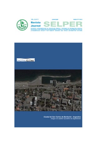
  • 1. VOL. 26, Nº 1 JUNIO2008 ISSN 0717-2915 SOCIEDAD LATINOAMERICANA DE PERCEPCIÓN REMOTA Y SISTEMAS DE INFORMACIÓN ESPACIAL SOCIEDADE LATINO-AMERICANA EM SENSORIAMENTO REMOTO E SISTEMAS DE INFORMACAO ESPACIAI LATINAMERICAN SOCIETY FOR REMOTE SENSING AND SPACE INFORMATION SYSTEMS Ciudad de San Carlos de Bariloche - Argentina Imágen de satélite QuickBird de DigitalGlobe
  • 2. SOCIEDAD LATINOAMERICANA DE PERCEPCION REMOTA Y SISTEMAS DE INFORMACION ESPACIAL SOCIEDADE LATINO-AMERICANA EM SENSORIAMENTO REMOTO E SISTEMAS DE INFORMACAO ESPACIAI LATINAMERICAN SOCIETY ON REMOTE SENSING AND SPACE INFORMATION SYSTEM SELPER VOL. 26 Nº 1 JUNIO 2008 ISSN 0717-2915 FOTO PORTADA San Carlos de Bariloche - Argentina Imagen de satélite QuickBird de DigitalGlobe, producto Pansharpened resolución espacial 0.60 metros, en composición Color Natural (3,2,1) de la Ciudad de San Carlos de Bariloche. Esta majestuosa ciudad se encuentra a orillas del lago Nahuel Huapi, espejo de agua que junto a montaña y bosques integra el contexto de uno de los lugares más bellos del mundo. Esta ubicada al oeste de la provincia de Río Negro y a 1.640 kilómetros de la ciudad de Buenos Aires. En la imagen se observa el Centro Cívico de Bariloche y el puerto de la ciudad a orillas del Lago Nahuel Huapi. Esta ciudad fue sede del V Simposio Latinoamericano de Percepción Remota, en el año 1989. EJEMPLAR DE DISTRIBUCION GRATUITA. PROHIBIDA SU VENTA
  • 3. REVISTA 2 VOL. 26 Nº 1 JUNIO 2008 DIRECCIONES DE CONTACTO SELPER DIRECTORIO SELPER, SEDE COLOMBIA, 2006 - 2008 Centro para el Estudio de Sensores Remotos y SIG Av. 11 de Septiembre 2155 - A Of. 902 Tel.: 562 - 334 - 3923/946 - 0302 E-mail: mardila@prosis.com PRESIDENTE Myriam Ardila Torres Colombia VICE-PRESIDENTE VICE-PRESIDENTE VICE-PRESIDENTE Carlos Pattillo Eloy Pérez Jaime Molina Chile Cuba Colombia SECRETARIO GENERAL RESPONSABLE DE DIVULGACIÓN ELECTRÓNICA TESORERO Luz Angela Rocha Walter F. Sione Carlos Niño Colombia Argentina Colombia COMITÉ DE RELACIONES INTERNACIONALES COMITÉ EDITORIAL COMITÉ DE EDUCACIÓN Paulo Roberto Martini (Brasil) María Cristina Serafini (Argentina) Tania María Sausen (Brasil) Presidente Presidente Presidente Aurelie Sand – Francia Miriam Esther Antes – Argentina José Luis Lizeca - Bolivia Maurizio Fea – Italia Leila María Fonseca – Brasil Silvia Casas - México Alfredo Cuello – Argentina Eder Gutierrez – Colombia Alina Ariñez. - Bolivia Victor Barrena - Perú Fabián Lozano – México Mirta Raed - Argentina Lissette Correa – Bolivia Jorge Luis Martin – Cuba Sandra Huerta Bustamante - Chile Rodolfo Ayala – Bolivia Stephan Dalence M. – Bolivia Maria Antonia García Cisnero - Cuba María Elena Pezoa - Chile Glenda Lee - Guatemala Olga Piedad Rudas - Colombia Laurent Polidori, Guayana Francesa Anyul del Pilar Mora - Colombia Monica Rabolli - Argentina Luis Geraldo Ferreira - Brasil Andres Cárdenas - Colombia Ethel Rubín de Celís Llanos - Perú CAPÍTULOS CONSTITUIDOS GUATEMALA CAPÍTULOS ESPECIALES Carlos Alberto Duarte ARGENTINA Ingeniería Virtual ALEMANIA Francisca Celia González Ruta 4, 6-49 Zona 4, Oficina 14 Klaus Reiniger Universidad Nacional del Sur Ciudad de Guatemala (01004), Guatemala DLR Departamento de Geología Tel: 502 - 334-1039/4038 D-8031 Oberpfaffenohfen San Juan 670 (8000) Fax: 502 - 331-9390 Alemania Bahía Blanca, Argentina E-mail: chduarte@hotmail.com Tel: 49- 8153- 281.189 Tel: 54 - 291 - 459 5102 - int. 4360 Fax: 49- 8153- 281.443 Fax: 54 - 291 - 459 5127 GUYANA FRANCESA E-mail: ghgonzal@criba.edu.ar Laurent PolidoriI CANADÁ Directeur de Recherche IRD / US ESPACE 140 Fritz P. Dubois BOLIVIA Institut de Recherche pour le Développement 25 Nidland Rodolfo Ayala (ex-ORSTOM) Crs Nepean Ontario Kh2-8n2 Carrera de Topografía y Geodesia Route de Montabo - BP 165 - 97323 Cayenne Ontario, Canadá Facultad Técnica cedex Tel: 613- 596-4164 Universidad Mayor de San Andrés Tel. (+594) 594 29 92 81 Fax: 613- 723-9626 Av. Arce 2299 1º Piso Fax (+594) 594 31 98 55 La Paz, Bolivia E-mail:polidori@cayenne.ird.fr ESPAÑA Tel.: 591-2-2441401 José L. Labrandero MÉXICO Consejo Superior de Investigaciones Científicas (CSIC) BRASIL Silvia Lucero Casas Pinar 25- Madrid 28006, España Leila María García Fonseca UAM Agronomía y Ciencias Tel: 34- 411.10.98 INPE Universidad Autónoma de Tamaulipas Fax: 34- 562.55.67 Av. Dos Astronautas 1758, Sao José dos Campos Centro Universitario Victoria San Pablo, Brasil Cd. Victoria Tamaulipas, México FRANCIA Tel: 55 - 12-39456000 E-mail: scasas@uat.edu.mx Jean-Luc Devynck E-mail: leila@dpi.inpe.br CNES URUGUAY Chef Dpt. Cooperation et Dévelopement CHILE Antonio Alarcón 2, Place Maurice Quentín, 75039 París Cedes 01 Gina Ghio Servicio de Sensores Remotos Aeroespaciales París, Francia AYS Ltda Fuerza Aérea Uruguaya Tel: 33-1- 447.67500 Calle Teatinos 258 of 811 Ruta 101 s/n Km. 19500 Fax: 33-1-447.67849 Santiago, Chile. Carrasco, Canelones, Uruguay E-mail: Jean-Luc.Devynck@cnes.fr Tel: 562 - 6903768 Tel.: 598 -2 601 4083 Fax: 562 - 6903790 Fax: 598 -2 601 4090 HOLANDA E-mail: jnovikov@codelco.cl E-mail: director@ssra.gub.uy Carlos Valenzuela ITC COLOMBIA VENEZUELA 350 Boulevard 1945, P.O.X. 6. 7500 AA Myriam Ardila Ramiro Salcedo Enschede, Holanda PROSIS S.A. Centro de Procesamiento Digital del Instituto de Tel.: 31 53 874-444 Calle 94 A n° 11 A-70 Ingenieria en Caracas Fax: 31 53 874-400 Santa Fe de Bogota, Colombia Apdo. Postal 40200 / Caracas, Venezuela Tel: 57-1-6357272 Tel/fax: 58 - 212 - 903 -4682 ITALIA Fax: 57-1-6357190 E-mail: ramiros@fii.org Maurizio Fea E-mail: mardila@prosis.com ESA/ESRIN PERÚ Via Galileo Galilei, 00044 CUBA Victor Barrena Arroyo Frascati, Italia Eloy Pérez García Universidad Nacional Agraria La Molina Casilla Postal 64 UCT GEOCUBA IC Av. La Universidad s/n Tel: 39 - 694180940 Calle 4 No. 304, e/ 3ra y 3ra A La Molina, Lima, Perú Fax: 39 - 694180942 Miramar, Playa, La Habana, Cuba CP 11 300 Tel / Fax: 51-1-349-5647 anexo 232/349-2041 E-mail: Maurizio.Fea@esa.int investigaciones@geocuba.co.cu E-mail: vbarrena@lamolina.edu.pe USA ECUADOR CAPÍTULOS EN FORMACIÓN Patricia M. Ravelo José R. Aguiar V. SPOT CLIRSEN Estados Unidos PARAGUAY Edif. Instituto Geográfico Militar, Piso 4 Tel: 1-800-ask-spot ext. 137 Sergio M. Burgos Sosa Seniergues s/n y Paz y Miño Fax: 703-648.1813 IPPA Apartado Postal 17-08-8216 E-mail: ravelo@spot.com Dr. César Sánchez 431 Quito, Ecuador San Lorenzo, Paraguay Tel.: 593- 2- 254-3193 Tel/Fax: 595- 21-574909 Fax: 593- 2- 255-5454 Email: smburgos@highway.com.py E-mail: clirsen@clirsen.com
  • 4. REVISTA VOL. 26 Nº 1 SELPER INDICE TEMÁTICO Y COMITÉ EDITORIAL JUNIO 2008 03 COMITÉ EDITORIAL ÍNDICE TEMÁTICO María Cristina Serafini (Argentina) PRODITEL Universidad Nacional de Luján Cruce rutas 5 y ex 7 (6700) Luján, Buenos Aires, Argentina ANÁLISIS ESPACIO-TEMPORAL DE LA Tel: 54-2323-423171 int 248 EVAPOTRANSPIRACIÓN DE REFERENCIA (ETo) EN Fax: 54-2323-425795 E-mail: proditel@mail.unlu.edu.ar CUBA Alberto A. Méndez Jocik Miriam Esther Antes (Argentina) PRODITEL Oscar José Solano Ojeda Universidad Nacional de Luján Cruce rutas 5 y ex 7 Diuris Ruiseco Hernández Luján, Buenos Aires, Argentina Tel: 54-2323-423171 int 248 Felicita González Robaina .......................................................................5 Fax: 54-2323-425795 E-mail: proditel@mail.unlu.edu.arx Leila María Fonseca (Brasil) IMAGE CLASSIFICATION ON A MOUNTAINOUS AREA INPE Av. Dos Astronautas 1758, Sao José dos USING OBJECT-BASED IMAGE ANÁLISIS Campos, Sao Paulo, Brasil Yan Gao Tel: 55 - 12-39456000 E-mail: leila@dpi.inpe.br Jean François Mas................................................................................. 15 Fabián Lozano (Mexico) Instituto Tecnológico y de Estudios Superiores de Monterrey TELEOBSERVACIÓN APLICADA A LA Av. Euganio Garza Sada # 2501 sur, Col. Tecnológico, Monterrey, Nuevo CARACTERIZACIÓN MORFOÓGICA Y EVOLUTIVA DE León, México COBERTURAS DE SUELOS EN LA LLANURA DE Tel: 52 - 81 - 8358 - 1400 ext 5275 Fax: 52 - 81 - 8358 - 6280 INUNDACIÓN DEL RÍO PARANÁ E-mail: dflozano@itesm.mx Lisandra P. Zamboni Eder Gutierrez (Colombia) SELPER Capítulo Colombia Pablo Aceñolaza Carrera 30 No. 48-51 Edificio IGAC-CIAF Walter Sione Of. 212 Bogotá, Colombia Fabio Kalesnik Tel: 57-1-369-4096 Fax:57-1-369-4096 Cristina Serafini ..................................................................................... 24 E-mail: edergutierrezd@gmail.com Jorge Luis Martìn (Cuba) SVD SA MAPEAMENTO DE ÁREAS URBANIZADAS COM O Montevideo 451 2º 24 USO DE IMAGENS LANDSAT E ANÁLISE ORIENTADA Capital Federal - Argentina Tel: 54 - 11 4371 - 8441 / 9547 A OBJETO E-mail: ciencia@geocuba.co.cu Claudia Durand Alves Stephan Dalence (Bolivia) ABTEMA Íris De Marcelhas E Souza Reyes Ortíz No 41 - Piso 13 Casilla 14248 La Paz, Bolivia Madalena Niero Pereira Tel: 591 - 2 - 521 259 / 113 Teresa Galloti Florenzano...................................................................... 33 Fax: 591 - 2 - 315 220 E-mail: dalence@clas.umss.edu.bo COMITÉ DE EVALUADORES Héctor del Valle (CENPAT - Argentina) Alfredo Cuello (UNLu - Argentina) Francisca González (UNS - Argentina) Graciela Marín (SEGEMAR - Argentina) Editado por: SELPER Internacional Universidad Nacional de Luján Rutas 5 y ex 7, (6700) Luján - Bs. As. - ARGENTINA EJEMPLAR DE DISTRIBUCIÓN GRATUITA PROHIBIDA SU VENTA
  • 5. VOL. 26 Nº 1 REVISTA 4 JUNIO 2008 PRESENTACIÓN DEL PRESIDENTE DE SELPER SELPER PLAN EDITORIAL SELPER 2006 - 2008 PLAN EDITORIAL SELPER A partir de las decisiones adoptadas en el marco del X Simposio Latinoamericano de Percepción Remota y Sistemas de Información Espacial, organizado por nuestra Sociedad; llevado a cabo en Cochabamba, Bolivia, en noviembre de 2002, el Comité Editorial ha tomado el compromiso de regularizar las publicaciones de la Revista Técnica Científica. En este sentido es necesario destacar el invalorable apoyo obtenido de la Agencia Espacial Europea (ESA) por la impresión de los volúmenes correspondientes a los años 2000, 2001, 2002, 2003, 2004, 2005 y 2006 respectivamente, los cuales se encuentran disponibles para los miembros de nuestra Sociedad. La 1º edición del año 2007 se llevó a cabo gracias al importante aporte recibido por parte del Capítulo Nacional Selper México. En esta oportunidad hacemos llegar la publicación del volumen 26 número 1, donde se incluyen trabajos que han sido enviados por especialistas en el área de Teledetección y SIG que desarrollan sus actividades en diferentes instituciones de América Latina, los cuales han sido remitidos a expertos evaluadores para su revisión y aprobación. Nos toca agradecer muy especialmente la labor llevada a cabo por el grupo de evaluadores que ha participado en la revisión de los mismos. NORMAS PARA LOS AUTORES Los artículos recibidos serán enviados a tres (3) f) Resultados obtenidos expertos en la temática para su revisión. Los g) Conclusiones trabajos aprobados serán publicados en estricto h) Bibliografía: sólo se incluirá la citada en el orden, de acuerdo a las fechas de llegada de las texto. Se indicarán los autores, por orden contribuciones. alfabético, año, título, revista o medio donde fue Los idiomas oficiales SELPER son: Español, publicado, incluyendo volumen y páginas, cuando Portugués e Inglés. corresponda. Los trabajos deberán estructurarse contemplando las siguientes secciones: Los títulos y subtítulos de cada sección deberán e s ta r c l a r a m e n t e i n d i c a d o s ( y a s e a c o n a) Título del trabajo. Nombre de los autores y numeración o tamaño de letras). Las tablas, fotos direcciones completas y figuras deberán ser suficientemente nítidas, b) Resumen (no más de 150 palabras) llevar un título y estar numeradas en forma indicando al final las palabras claves. Deberá consecutiva. incluirse en Español o Portugués, además de Se deberá enviar una copia del trabajo en Inglés formato Word y una copia papel. La extensión c) Introducción total del trabajo no deberá superar las 12 páginas, d) Objetivos (DIN-A4). e) Metodología empleada y materiales Los trabajos se enviarán a: editorial@selper.org
  • 6. REVISTA 05 VOL. 26 Nº 1 JUNIO 2008 ANÁLISIS ESPACIO-TEMPORAL DE LA EVAPOTRANSPIRACIÓN... SELPER Análisis espacio – temporal de la evapotranspiración de referencia (ETo) en Cuba. Alberto A. Méndez Jocik * Oscar José Solano Ojeda ** Diuris Ruiseco Hernández *** Felicita González Robaina **** * Dpto. de Geomática. Empresa Nacional de Proyectos Agropecuarios de Cuba. mendez@enpa.cu Conill y Ave. Boyeros. Ministerio de la Agricultura de Cuba, Piso 10. ** Dpto. de Agrometerelogía. Instituto de Meteorología de Cuba. oscar.solano@insmet.cu *** Diuris Ruiseco Hernández . Universidad Nacional Agraria de la Habana, UNAH. Cuba. diurislu@isch.edu.cu **** Dpto. de Investigaciones del Instituto de Investigaciones de Riego y Drenaje de Cuba. IIRD. felicita@iird.cu RESUMEN años 90 la FAO establece el método de Penman- Monteith como procedimientoestándar para su La evapotranspiración (ET) constituye el segundo determinación donde se requiere de observaciones elemento del ciclo hidrológico del agua en la sinópticas de estaciones meteorológicas, las cuales atmósfera, a ella están ligados diversos y complejos no siempre están disponibles ni distribuidas procesos en el que intervienen agua, suelo planta así espacialmente de forma que mediante como otros aspectos medioambientales y de manejo, interpolaciones se pudiera suplir de información de su determinación y utilización hace imperante por algunas zonas adyacentes, con un nivel de confianza especialistas que planifican, toman decisiones, requerido o al menos informarlo. explotan los recursos hídricos, ambientales y las El área de Cuba es de110 860 Km2 (ACC 1989), de geociencias en general. acuerdo a informaciones del Instituto de Meteorología En los años 90 la FAO establece el método de existen unas 68 estaciones climáticas de diversas Penman-Monteith como procedimiento estándar para categorías que realizan observaciones del clima de su determinación donde se requiere de observa- ellas 62 pueden proveer de informaciones necesarias ciones sinópticas de estaciones meteoro-lógicas las para la estimación de de la evapotranspiración de cuales generalmente no están distribuidas referencia lo que daría una densidad de cubrimiento espacialmente que mediante herramientas de 1788 K2, estas estaciones fueron situadas no geoestadísticas se pudiera suplir de información atendiendo a un objetivo agroclimático (algunas de precisa de algunas zonas adyacentes con un nivel de ellas situadas en puntos como cayos, costas etc.) por confianza requerido. tal motivo si se pretende realizar un análisis para En Cuba uno de lo trabajos mas relevantes y actuales áreas de interés agropecuario debe tenerse en son los desarrollados por el Instituto de Meteorología cuenta cuales deben seleccionarse a fin de no (Solano 2003), donde publica las tasas de generalizar información (propagación de errores), al evapotranspiración de referencia del Territorio realizar una interpolación utilizando cualquiera de los Nacional, el presente trabajo pretende complementar métodos existentes siempre el número de datos estos estudios ofreciendo una metodología de trabajo disponibles y su distribución espacial constituye la para la obtención de mapas de intervalos de primera limitante, pero haciendo un análisis objetivo confianza dotando al estudio de resultados para poder realizar cualquier estudio relacionado con cualitativos. la evapotranspiración de referencia es obligado a recurrir a esta fuente de información al no existir otra, INTRODUCCIÓN si se consulta información a cerca de la variabilidad espacial y temporal de la evapotranspiración en Cuba, La evapotranspiración (ET) constituye el segundo las publicaciones son insuficientes y algunas carecen elemento del ciclo hidrológico del agua en la de un nivel de robustez requerido ya que están atmósfera, a ella están ligados diversos y complejos basados en análisis de datos los cuales fueron procesos en el que intervienen agua, suelo planta así generalizados a niveles mensuales y de períodos como otros aspectos medioambientales y de manejo; hidrológicos donde se enmascara la verdadera su determinación y uso se hace imperante naturaleza de la variabilidad espacial y temporal de la porespecialistas que planifican, toman decisiones y ET; la FAO recomienda la utilización de informaciones explotan los recursos hídricos, ambientales y las decenales para este tipo de estudio (Smith 1990), geociencias en general. Desde siglos pasados se han entre los trabajos relevantes son de obligada consulta generado una serie de modelos biofísicos y empíricos los desarrollados por el Instituto de Meteorología para lograr su aproximación pero siempre ha existido "Zonificación de la evapotranspiración de referencia una limitación que es la alta variabilidad espacial y en Cuba. Atlas Agrometeorológico de temporal de cada uno de sus componentes, en los disponibilidades hídricas para una agricultura de
  • 7. REVISTA 06 VOL. 26 Nº 1 JUNIO 2008 ANÁLISIS ESPACIO-TEMPORAL DE LA EVAPOTRANSPIRACIÓN... SELPER secano" (Solano 2003) al no existir otros autor fue el seleccionado y utilizado (cortesía de su antecedentes basados en análisis de series a nivel autor) en los posteriores análisis de este trabajo. decenal en el país. Como procedimiento de trabajo se estableció el El presente trabajo tiene como objetivo siguiente: complementar este estudio estableciendo una metodología para el manejo de datos geoespaciales · Análisis estadístico exploratorio descriptivo de la de esta naturaleza haciendo un análisis espacio totalidad de los datos sin realizar ninguna temporal de esta variable y determinando los transformación. intervalos de confianza para las tasas de evapotranspiración de referencia, dotando al mismo · Prueba de Normalidad de Anderson - Darling la cual de un análisis cualitativo necesario para la toma de es recomendada como la prueba más robusta decisiones económicas, ambientales y de seguridad existente y valida cuando se quiere precisar los alimentaría. limites de la serie en cuanto a la normalidad, varios autores (Brown 1974; Filliben 1975; Sheather 1986) MATERIALES Y MÉTODOS la consideran superior a las pruebas de Ryan-Joiner y Kolmogorov-Smirnov. Para el presente estudio fueron utilizados datos decenales de series históricas (30 años), mapas e · Análisis grafo - analítico de la distribución espacial y informaciones obtenidas del Atlas Agrometeorológico temporal de la ETo. de disponibilidades hídricas para una agricultura de secano publicados por el Instituto de Meteorología · Estratificación de las poblaciones de la series de ETo (Solano 2003) (cortesía de sus autores), donde se a partir de la geomorfología . ofrecen los datos de ETo para el Territorio Nacional de 62 estaciones climáticas determinados por el · Establecimiento de las nuevas clases a partir de las procedimiento estándar de FAO-Penman-Monteith series de ETo obtenidas. (Allen 1998). · Verificación de la normalidad de las clases. ·Análisis de patrones para identificar el comportamiento espacial de los datos. · Cálculo de los semi-variogramas experimentales. · Modelación de los semi-variogramas y establecimiento de los modelos. · Interpolación mediante el método del Kriging. · Cálculos de los errores (desviación estándar). FIG. 1. Localización de las estaciones · Estadística descriptiva y prueba de normalidad de climáticas en Cuba los errores. Para la aplicación de la metodología es necesario · Establecimiento de los intervalos de confianza. realizar una estratificación de los valores de ETo mediante la geomorfología del relieve por la influencia ·Mapificación y despliegue de los resultados que este aporta a la variable de estudio (Smith 1990), mediante sistemas de información geográficos (SIG). por este motivo se necesitan informaciones de esta naturaleza. Al consultar información al respecto de ANÁLISIS Y DISCUSIÓN DE LOS RESULTADOS los estudios realizados en Cuba existen diferentes criterios (Hernández S.J 1993) señala que los Estadística exploratoria descriptiva: Se realizó un resultados actuales de investigación de la análisis estadístico exploratorio con la totalidad de los geomorfología cubana obtenidos hasta hoy, reflejan datos sin realizar ninguna transformación según lo un grado desigual e insufic iente de estudio dado por que sugiere Rossiter (2003) para determinar la diversas causas. Uno de los trabajos más recientes naturaleza de los datos y en qué sentido se debe que considera los estudios antes realizados y utiliza orientar los siguientes pasos de la investigación . técnicas más avanzadas es el desarrollado por Reyes (Rossiter 2003) La Prueba de Normalidad de (2004) donde utiliza procesamientos utilizando Anderson - Darling en todos los casos muestra técnicas de radar (Shuttle Radar Topography Misión. suficiente evidencia para afirmar que ninguna de las Jet Propulsión ) con resoluciones espaciales de 90 m series se comportan como una distribución normal (NASA 2002). para el nivel de significación (a=0.05), entre las El modelo digital de elevaciones propuesto por su muestras se observa que existen diferencias entre las
  • 8. REVISTA 07 VOL. 26 Nº 1 JUNIO 2008 ANÁLISIS ESPACIO-TEMPORAL DE LA EVAPOTRANSPIRACIÓN... SELPER Fig.2 Histograma ETo de todas las series Fig. 3 Evapotranspiración de refe rencia por estaciones climáticas Tabla 1. Estadística descriptiva exploratoria de todas las series
  • 9. REVISTA 08 VOL. 26 Nº 1 JUNIO 2008 ANÁLISIS ESPACIO-TEMPORAL DE LA EVAPOTRANSPIRACIÓN... SELPER medias (Min.= 26.871 y Máx.=52.853) con La introducción del Lapso Adiabático para varias coeficientes de variación (CV min.= 6.590 y CV Máx.= alturas fue introducido por Hargreaves (1980) y el 11.810) provocadas a que los datos se distribuyen en factor de índice de aridez presentado por Allen y Pruitt diferentes poblaciones como se muestra en el (1986) son útiles ejemplos de esto; el panel señalaba histograma de la Fig. 2 lo que permite suponer que los además que las técnicas de teledetección pueden datos obedecen a una distribución que pudiera proveer de adicional información sobre la variabilidad depender de la va riabilidad espacial (X, Y, Z) y espacial (Smith 1990). Por este motivo la temporal (T) como se muestra en la Fig. 3, este estratificación de las series de ETo se realizó teniendo análisis define 3 direcciones de la investigación: en cuenta la geomorfología del relieve atendiendo a la 1-Los análisis deben considerar la variabilidad clasificación antes mencionada (Reyes 2004). temporal de la evapotranspiración de referencia para Sobre la transformación de series para su lo cual hay que decidir cual es el periodo en el cual se normalización algunos autores (Rossiter 2003) establecen los valores más representativos de la sugieren trabajar con datos sin transformar serie . estratificándolos de forma tal que los agrupe en 2-Los datos pueden estar influenciados por una poblaciones cuyos extremos se encuentren dentro de variabilidad espacial (X, Y, Z) que pudiera determinar una serie normalizada, respondiendo a un principio su agrupamiento. biofísico y no matemático. 3- Las series no presentan un comportamiento Los datos de evapotranspiración de referencia fueron Normal lo que implica su transformación para poder estratificados quedando normalizados excepto en el emplear métodos de interpolación basados en el primer estrato (0 – 40 m) donde fue necesario supuesto de obedecer a una distribución Gausiana. reclasificarlo en 2 partes (0 -15 m) y (16 - 40 m) ya que Para decidir el período donde la variabilidad temporal aun existen 2 poblaciones en una misma serie, en el sea representativa de la serie, al analizar la Fig.3 se caso de las series 85-125, 459-800 y 800-1500 se muestra la alta variabilidad temporal de la ET aún agruparon normalmente dentro de una misma serie. cuando se utilizaran series diarias u horarias. Las diferentes series quedaron agrupadas en las Sobre la variabilidad temporal de la evapo- clases que se muestran en la Tabla No 2. transpiración existen pocos trabajos realizados, sobre esto en un panel de expertos agrupados por la Tabla 2. Clases obtenidas de la estratificación FAO en Roma, Smith (1990) señalaba que los geomorfológica procedimientos para analizar la varianza estadística de las precipitaciones se ha convertido en calculo de rutina, tales procedimientos no han sido llevados a cabo en el caso de la evapotranspiración y otras variables climáticas de un comportamiento no normal, estudios comparativos adicionales para estimar la variabilidad temporal y recomendar los procedimientos prácticos en la planificación y explotación de los recursos hídricos necesitan ser Para la estimación de la evapotranspiración (ETo) la realizados. determinación del número de datos necesarios para Este panel de expertos establecía tiempos escala en que los resultados se encuentren dentro del intervalo el estudio de la evapotranspiración y señalaba que de confianza (en este caso un 95 % de probabilidad), estos están en dependencia del propósito de la lo deseable es que la ETo se estime con un máximo aplicación que se quiera realizar y la precisión del valor de confiabilidad y teniendo en cuenta que esta método de predicción con que se trabaje variable está expresada en lámina (1 mm – 10 m3/ha) recomendando intervalos diarios, decenales y consideraremos 0.5 mm de margen de error. mensuales para el método utilizado.(Smith 1990) Por lo antes señalado y teniendo en cuenta que el Intervalo de confianza para la población de una media presente estudio pretende obtención de valores de ET con fines de planeamiento hidráulico y explotación para usos de regadíos estableceremos el tiempo escala de 10 días. ( 1) Variabilidad espacial de la ET Donde: El panel de expertos antes mencionado señalaba a su Valores medios de la serie vez que el uso de datos climáticos de estaciones Valores tabulados de la distribución normal para un meteorológicas para áreas agrícolas presenta nivel de confianza (1.960 para un 95 % de diferentes limitaciones, los procedimientos en que se probabilidad) trabaje para la determinación de la evapo- ? : Desviación estándar de la serie transpiración deben tomar en cuenta las diferencias n : Número de observaciones micro climáticas, vegetación, suelos y cambios de altitud.
  • 10. REVISTA 09 VOL. 26 Nº 1 JUNIO 2008 ANÁLISIS ESPACIO-TEMPORAL DE LA EVAPOTRANSPIRACIÓN... SELPER Como se observa en la tabla No. 3 en todas las clases estaciones climáticas con informaciones para estimar es necesario un número de datos superior a los la evapotranspiración de referencia, estas deberían existentes para obtener un margen de error adecuado estar situadas a su vez con una distribución espacial lo que implicaría que existieran en el país unas 684 que se lograra una densidad adecuada en cada lugar. Tabla 3 Número de datos necesarios para un margen de error de 0.5 mm de ETo de intervalo de confianza de la media para un 95 % de probabilidad Trabajar con datos insuficientes puede provocar márgenes de errores (Tabla No.4) con valores sobreestimados o subestimados de evapotrans- piración. Por otra parte si se quiere lograr una interpolación precisa utilizando técnicas geoestadisticas como el Kriging (interpolador óptimo) sería necesario estimar de forma fiable los semivariogramas experimentales lo que requiere un tamaño de muestras mínimo. Gascuel (1994) en su trabajo sobre la variabilidad de estimaciones espaciales considera 150 datos y apunta como un número suficiente, mientras Webster (1992) considera esta cantidad como el límite inferior y recomienda un tamaño de muestra de 225. Fig. 4. Análisis de patrones de la evapotranspiración de Tabla 4. Cuantificación en unidades de norma de riego del referencia. margen de error En las figuras (Fig.5-9) cual se muestran los semivariogramas experimentales para cada clase Análisis de patrones En las interpolaciones se asume que existe una aleatoriedad espacial de los puntos, para examinar el comportamiento de los datos de puntos en el espacio e investigar si estos están distribuidos al azar se utiliza el análisis de patrones (Fig 4), dos técnicas Fig. 5 0-15 m básicas se utilizaron para examinar el modelo espacial de puntos, distancia de vecinos más cercanos y reflexivos vecinos más cercanos.
  • 11. REVISTA 10 VOL. 26 Nº 1 JUNIO 2008 ANÁLISIS ESPACIO-TEMPORAL DE LA EVAPOTRANSPIRACIÓN... SELPER Fig. 6 16-40 m Fig. 7 41-85 m Fig.8 85-1500 m Fig. 9 Semivariograma experimental todas las clases. De acuerdo a los semivariogramas se observan que 2- 3.5 mm altos si se compara con los valores medios existen dependencias espaciales entre los rangos de que se sitúan entre Min.= 2.6871 mm y Máx.=5.2853 0-400 Km. respecto a la evapotranspiración de mm en este rango de distancias. referencia, esta información puede servir de base en En las Fig. 10-19 se muestran los resultados la distribución de las estaciones climáticas, por otra obtenidos de la interpolación de la evapotrans- parte la semivarianza oscila entre rangos de 4-12.5 piración de referencia mediante un Kriging ordinario y mm que implican desviaciones estándar de la media sus respectivos mapas de errores. Tabla 5 Parámetros de los semivariograma para todas las clases
  • 12. REVISTA 11 VOL. 26 Nº 1 JUNIO 2008 ANÁLISIS ESPACIO-TEMPORAL DE LA EVAPOTRANSPIRACIÓN... SELPER Fig. 10-11 Clase 0-15 m Fig. 12-13 Clase 16 -40 m Fig. 14-15 Clase 41-85 m Fig. 16-17 Clase 85-1500m Fig. 18-19 Evapotranspiración de referencia I decena mes de enero y mapa de errores. A partir de la combinación de los mapas estimados comportamiento normal de los errores, los valores mediante el Kriging ordinario y sus mapas de errores críticos de intervalos de confianza se obtuvieron de la se crearon mapas de intervalos de confianza tabla de valores estándar de la curva norma (Tabla 6)l. mediante mapas de cálculos, verificando el
  • 13. REVISTA 12 VOL. 26 Nº 1 JUNIO 2008 ANÁLISIS ESPACIO-TEMPORAL DE LA EVAPOTRANSPIRACIÓN... SELPER Tabla 6 Intervalos de confianza y valores críticos de la curva normal. Donde son los valores de Kriging estimado y el error estimado (estándar desviación). La multiplicación del factor c (Valor critico) por los valores estimados en el mapa de errores de una cara de los intervalos de confianza provoca la obtención de los mapas de intervalos de confianza para la media. Del histograma del mapa de errores se evalúa la estadística descriptiva y la prueba de Anderson – Darling para verificar la normalidad, en los gráficos de las Fig., 20 y Fig.21 Se muestra la normalidad de los errores lo que permite estimar los intervalos de Fig. 22 Intervalos de confianza de la evapotranspiración confianza. de referencia Los resultados del análisis del mapa de intervalos de confianza y el histograma (Fig 22 y 23), nos muestran zonas de "incertidumbres " donde los intervalos de confianza presentan desviaciones entre 5-6 mm, esto coincide con las zonas donde la densidad de estaciones climáticas es baja e inclusive nula situadas en las zonas oeste de la Isla en las regiones centrales de la Provincia de Pinar del Rió pertenecientes a los municipios de San Juan y Martínez , Minas de Matahambre, Viñales, La Palma, Bahía Honda y San Cristóbal, similar comportamiento aparece en la región este del país en los municipios costeros de la Provincia de Granma como son Campechuela, Media Luna y Niquero y en la provincia de Holguín en el municipio de Moa, otras de las Fig. 20 Estadística descriptiva mapa de Errores regiones del mismo comportamiento es la región mas oriental de la isla en la Provincia de Guantánamo en los municipios de Yateras, San Antonio del Sur, Manuel Tames, Baracoa, Imias y Maisi todas estas áreas representan un 7.2 % del territorio nacional, en las restantes zonas del país unas 10,713,750 ha se comportan dentro de los rangos de intervalos de confianza de 0.5-4 mm, y representan el 92.6 % de las áreas de Cuba. Diferentes autores coinciden que las medidas de teledetección espacial permiten extender los modelos de cálculo a zonas amplias donde no se dispone de datos meteorológicos (Rivas 2004; Rivas. R 2004) y proponen una serie de modelos basados en el estudio de diferentes sensores y variables Fig. 21 Intervalos de confianza de la Prueba Anderson Darling En la figura 22 se muestra el mapa de los intervalos de confianza para la media de la evapotranspiración de referencia de la primera decena de enero evaluado para un 95% de probabilidad. Fig. 23 Histograma Intervalos de confianza
  • 14. REVISTA 13 VOL. 26 Nº 1 JUNIO 2008 ANÁLISIS ESPACIO-TEMPORAL DE LA EVAPOTRANSPIRACIÓN... SELPER obtenidas a partir de técnicas de teledetección (Jiang que limita el uso de datos puntuales de estaciones 2003; Batra 2005; Batra climáticas cuando estas no se encuentran con una 2006; Wang 2006; Bisht 2005). densidad adecuada y distribuidas uniformemente, Por otra parte existe una tendencia mundial a la aún cuando se utilicen procedimientos y métodos utilización sistemas inteligentes para la modelación geoestad?sticos avanzados (interpolador óptimo) lo de la evapotranspiración debido a la imposibilidad de que constituye una limitante al sobrestimar o medir directamente y de forma precisa (error subestimar los valores reales de la misma, debe instrumental), este parámetro, así como limitaciones restarse atención su utilización para evitar la en cuanto al conocimiento de las leyes biofísicas que propagación de errores o al menos informar el grado rigen este comportamiento, sobre este aspecto de confiabilidad con que se trabaja . Obregón (2002) (2003) señalaba que el estudio de 1. Es importante considerar las escalas de tiempo en sistemas complejos como es el caso de la la estimación de la evapotranspiración como lo evapotranspiración tal como se puede evidenciar no recomienda la literatura internacional y no trabajar en sólo en la “textura” de las diferentes variables de escalas superiores de una década, la generalización entrada y salida, sino también en el carácter no lineal de información a otras escalas utilizando estadígrafos de las funciones de transferencia y heterogeneidad de tendencia central como la media, desviación de sus parámetros, los modelos empleados en estándar y pruebas de normalidad enmascaran el ingeniería procuran incorporar expresiones que verdadero comportamiento de la serie. consideran la complejidad de dichos sistemas. Para 2. La metodología ofrecida puede servir de herra- tal efecto se acostumbra a generar aproximaciones mienta en el análisis y procesamiento de este tipo de que pueden ser empleadas en los diferentes información que presenta un carácter estocástico, ejercicios de modelación. Una primera discriminación probabilístico y difuso, la utilización de otros incluye los denominados modelos de “caja negra” y procedimientos estándar pueden inducirle otras los de “caja blanca”. En los primeros la característica fuentes de error. principal es la ausencia de algún principio físico como 3. Este estudio no es conclusivo solo tiene un carácter por ejemplo alguna de las leyes de conservación metodológico encaminado a proponer este (masa, momento o energía). Para los segundos por lo procedimiento de trabajo para la evaluación posterior menos se incluye una o varias de estas leyes. En los de todas las series históricas de la base de datos con primeros es común también hablar de dos tipos de que se cuenta pero es indicativo de similares modelos aquellos que se encuentran guiados por resultados a obtener al analizar otros períodos ya que datos y los basados en el conocimiento. Como los intervalos de confianza están determinados por la herramientas de éstos se destacan los denominados cantidad de estaciones climáticas existentes, su SISTEMAS INTELIGENTES. distribución geográfica y su densidad. 4. Recomendamos la combinación de estos CONCLUSIONES Y RECOMENDACIONES procedimientos de trabajo con técnicas de teledetección espacial modelados a partir de A la vista de los resultados obtenidos podemos sistemas inteligentes para tratar de reducir las concluir que:En las condiciones de Cuba la incertidumbres de algunas zonas donde la estimación evapotranspiración de referencia presenta una alta no ha alcanzado los valores deseados. variabilidad espacial (x,y,z) y temporal (t) coincidente con lo reportado por la bibliografía internacional, lo REFERENCIAS University Cincinnati. Master of Science 120. ACC, Ed. (1989). Nuevo Atlas Nacional de Cuba, Editado por el Instituto de Geografía de la Academia Batra, N., S., Islam, V., Venturini, G., Bisht, and L., de Ciencias de Cuba, el Instituto Cubano de Jiang. (2006). "Estimation and comparison of Geodesia y Cartografía y el Instituto Geográfico evapotrasnpiration from MODIS and AVHRR sensors Nacional de España for clear sky days over the Southern Great Plains. ." Remote Sens. of Environ. 103: 1-15. Allen, R., Pereira, L., Raes, D. and Smith, M. (1998). Evapotranspiración del cultivo. Guía para la Bisht, G., V., Venturini, S., Islam, and L., Jiang. ( 2005). determinación de los requerimientos de agua de los "Estimation of the net radiation using MODIS cultivos. Estudio FAO Riego y Drenaje No. 56. FAO: (Moderate Resolution Imaging Spectroradiometer) 298. data for clear sky days." Remote Sens. of Environ. . 97: 52-67. Batra, N. (2005). Estimation and comparation of Brown, M. B., Forsythe (1974). "Robust Tests for the Evapotranspiration from multiple satellites for clear Equality of Variances." Journal of the American sky days. Department of Civil & Environmental Statistical Association 69: 364-367. Engineering of the College of Engineering. Ohio, USA. , Filliben (1975). "The Probability Plot Correlation
  • 15. REVISTA 14 VOL. 26 Nº 1 JUNIO 2008 ANÁLISIS ESPACIO-TEMPORAL DE LA EVAPOTRANSPIRACIÓN... SELPER Coefficient Test for Normality." Technometrics 17: 111. estimate spatial reference evaporation from remote sensing-based surface temperature and local Gascuel, O. (1994). "Variability of variograms and meteorological data." Remote Sensing of spatial estimates due to soil sampling: a case study." Enviromental 93: 68-76. Geoderma 62: 165- 182. Rossiter, D. G. (2003). "Spatial Analysis & Hernández S.J, D. J. L., Portela P.A, Magaz G.A Geostatistics." Department of Earth Systems Analysis (1993). "Geomorfologia de Cuba." La evalolucion de International Institute for Geo-information Science & la morfologia. Academia de Ciencias de Cuba. Earth Observation (ITC): 283. Habana. Cuba.13 Sheather , H. (1986). "Confidence Intervals Based on Jiang, L., and S., Islam. (2003). "Estimation of surface Interpolated Order Statistics." Statistics and evaporation map over southern Great Plains using Probability Letters 4: 75-79. remote sensing data." Water Resources Research. 37(2): 329-340. Smith, M. (1990). Expert Consultation on Revision of FAO Methodologies for Crop water requirements. NASA (2002). Shuttle Radar Topography Mission, Land and Water Development Division. L. a. W. D. NASA. Division. Rome, Italy, FAO: 57. Obregón, N., & F. Fragala (2002). "Sistemas Solano, O., C. J. Menéndez, R. J. Vázquez y J. A. Inteligentes, Ingeniería e Hidroinformática." Ciencias Menéndez . I . (2003). Zonificación de la e Ingeniería Neogranadina Vol. 13. evapotranspiración de referencia en Cuba. Atlas agrometeorológico de disponibilidades hídricas para Obregón, N., & F. Fragala (2003 ). Some Applications una agricultura de secano 2 p, 4 Anexos, 102 mapas. of Artificial Intelligent Systems in Hydroinformatics. La Habana, Cuba, Instituto de Meteorología. Eighteeen International Joint Conference on Artificial Intelligence. Workshop Acapulco, Mexico. Wang, K., Li, Z., M., Cribb. (2006). "Estimation of evaporative fraction from a combination of day and Reyes, R. (2004). Geomorphometry characterization night land surface temperatures and NDVI: A new of Cuba by use Digital Elevation Model (DEM) From method to determine the Priestley – Taylor Shuttle Radar Topography Mission (SRTM) with 90 m parameter." Remote Sens. of Environ. 102: 293-305. of resolution. Netherland, International Institute for Geo-information Science and Earth Observation Webster, R., Oliver, M.A. (1992). "Sample adequately Msc.: 50. to estimate variograms of soil properties." Journal of Soil Science 43: 177– 192. Rivas, R., Caselies (2004). "A simplified equation to
  • 16. REVISTA 15 VOL. 26 Nº 1 JUNIO 2008 IMAGE CLASSIFICATION ON A MOUNTAINOUS AREA... SELPER Image classification on a mountainous area using object-based image analysis Yan Gao*1 and Jean François Mas* * Centro de Investigaciones en Geografía Ambiental, Universidad Nacional Autónoma de México (UNAM), Antigua Carretera a Pátzcuaro No. 8701, Col. Ex-Hacienda de San José de La Huerta C.P. 58190 Morelia Michoacán MÉXICO, Tel. (443) 322 38 35, E-mail: gaoyan@pmip.unam.mx, jfmas@ciga.unam.mx ABSTRACT bear either very general land-cover information, or else detailed information with limited accuracies Object-based image analysis classifies image objects (Franklin et al. 2003). In object based image analysis, which are created by image segmentation. Image homogeneous image objects at a chosen resolution segmentation delineates image objects according to a are first extracted and subsequently classified and the certain homogeneity criteria, and at the same time, results produced are smoother and closer to the requires spatial contingency. Since objects are human vision. The development of object based comprised of a group of pixels, the objects properties image analysis stems primarily from the desire to use such as mean, standard deviation, shape, texture, etc. the semantic information to interpret an image, which can thus be calculated and used in the image analysis. is not presented in single pixels but rather in Object-based image analysis uses object’s spectral meaningful objects and their mutual relations. Objects and spatial information, and information pertaining to are composed of groups of homogeneous pixels, and an object’s sub-or super-objects if a multi-level image thus more information than just the grey value can be object hierarchy has been created. With all these used in the classification, which considerably extends available features, it is critical the proper the possibilities for image analysis. Object based selection of features and thresholds to differentiate image analysis intends to do what an image the classes of interest. Normally, this selection of the interpreter does: recognizing the colour, shapes, proper features and thresholds relies on the expertise textures and coherent regions presented within an of the analyst and is performed on a trial and error image and associating meaningful objects and their process. In this paper, a SEaTH algorithm was used to contextual relations. calculate the proper features and thresholds based on A feature represents certain information concerning the properties of the selected representative objects objects of interest, such as spectral related of class. This paper performed land cover information, shape, texture, etc. It is important to classification using object based image analysis on identify the characteristic features for objects of Landsat-7 ETM+ imagery in a mountainous area with interest in order to differentiate objects of different complex land cover classes. In the definition of the land cover types. Usually, it is based on a time classifiers of the land cover classes, the used features consuming trial and error process. According to the and thresholds were calculated by SEaTH algorithm. selected training objects and features, Eight land cover classes were produced: temperate SEparability and Threshold (SEaTH) algorithm forest, tropical dry forest, orchards, grassland, calculates the proper features and thresholds that are irrigated agriculture, rain-fed agriculture, lava flow, best fit for the separation of interested classes. Based and human settlements. In this paper, it is on a statistical approach, it calculates the features and differentiated between object primitives and object of thresholds for any number of given features and any interest. Object primitives are building blocks in object number of interested classes, so it avoided the time- based image analysis and are produced by image consuming trial and error process. This paper segmentation; object of interest here corresponds to investigates the performance of object based image the earth objects. analysis for mapping land-covers in a mountainous Key words: Multi-resolution segmentation, Object- forested area, using the features and thresholds based image analysis, Separability and thresholds. identified by the SEaTH algorithm. 1. INTRODUCTION 2. METHODS 2.1. Object based image analysis in eCognition Pixel-based image classification usually produces highly freckled results in classifying images of Object based image analysis in eCognition (Definiens heterogeneous areas. The resulting thematic maps 2006) comprises two parts: multi -resolution 1 Corresponding author. gaoyan@pmip.unam.mx
  • 17. REVISTA 16 VOL. 26 Nº 1 JUNIO 2008 IMAGE CLASSIFICATION ON A MOUNTAINOUS AREA... SELPER segmentation and context-based classification. Multi - the maximum allowed heterogeneity for the resulting resolution segmentation allows generating image image objects. With a certain scale parameter, objects objects on an arbitrary number of scales considering are formed based on “colour” and “shape” homogeneity in colour and shape. characteristics, and the relation between these two Additionally, the created segments/objects are criteria is colour + shape = 1. “Colour” defines the embedded into a hierarchical network in which each weight the spectral values of the image layers object knows its neighbouring objects in horizontal contribute to image segmentation. Shape criterion is and vertical direction (figure 1) (Baatz and Schape represented by smoothness and compactness. 1999). The classification is based either on a fuzzy Smoothness is to optimize image objects with regard nearest neighbour classifier or membership function. to smooth borders, and compactness with regard to compact borders (Baatz et al. 2004). 2.1.1. Multi-resolution image segmentation Besides, for a given set of segmentation parameters, heterogeneous image data result in smaller image Multi -resolution image segmentation extracts objects objects than homogeneous image data. in a number of hierarchical segmentation levels, and each subsequent level yields image objects of a larger 2.1.2. The fuzzy classifier and hierarchical average size by combining objects from a level below, network classifier which represents image information on different scales simultaneously (figure1). The classification uses either nearest neighbour In image segmentation, scale parameter determines classifier (NN) or membership function, or a means Figure 1: Image object hierarchy. Source: Definiens professional 5 user guide combination of both. Object features can be used approach based on training objects. It measures the either to describe membership functions, or to statistical distance (Jeffries-Matusita distance) to determine the feature space for NN (Baatz and compare the feature separability of two interested Schape 1999). NN classifier is based on fuzzy logic, classes. The measure result is in interval of [0, 2], in which replaces the two Boolean logical statements which 0 implies that the class distributions in these two “true” and “false” by the continuous range of (0…1) features are completely correlated and 2 implies the where 0 means false and 1 means true and all values complete uncorrelation. between 0 and 1 represent a transition in between. The features in which the class has the high To guarantee a definite hierarchy the segmentation separability (high J value) are the optimum features. procedures follow two rules: 1) object borders must To apply this method in the classification in eCognition, follow borders of objects on the next lower level; 2) first of all, samples of the interested classes are segmentation is constrained by the border of the selected and the statistics (feature values) of those object on the next upper level. Different hierarchical samples are exported. levels can be segmented using different data, an The separability of the classes represented by J upper level, for example, can be built using thematic distance is then calculated, and the features with the information, whereas a lower layer is segmented high J distance are favorable features to differentiate using remote sensing data. Classifying the upper level, between land-cover classes. The selected favorable each object can be analyzed based on the features can then be used to build the rule base. It is a composition of its classified sub-objects. By means of parametric approach and the assumption is that all the this technique different data types can be analyzed in random variables encountered during the processing relation to each other. can be approximated as Gaussian distributions. 2.2. SEaTH algorithm 3. THE STUDY AREA AND DATA SEaTH algorithm was proposed by Marpu et al. The study area is located in Michoacán state, central (2006) and Nussbaum et al. (2006), the algorithm west of Mexico, covering an area of approximately identifies the characteristic features with a statistical 58*60 km 2 , within the longitude of 102° 00’ W and
  • 18. REVISTA 17 VOL. 26 Nº 1 JUNIO 2008 IMAGE CLASSIFICATION ON A MOUNTAINOUS AREA... SELPER 102° 32’ W, and latitude of 19° 02’ N and 19° 36’ N (figure 2). Figure 2: The study area. Left side of the figure are two sketch maps indicating Mexico and Michoacán state where the study area is located; right side is the false colour composite of Landsat-7 ETM+ image with red, green, and blue bands of 4, 5, and 7. The available data are comprised of a Landsat-7 different information that is defined in the attached ETM+ image obtained on 16 February 2003, with 6 attribute list. To be able to clearly define the affiliation bands and a spatial resolution of 30m, a mosaic of 25 of an object to a thematic class given by the themati c ortho-corrected photos taken in 1995 with 2 meters layer, it is not possible to create image objects which spatial resolution, and a land-cover map from the belong to different thematic classes. To ensure this, Forest Inventory generated in the year 2000. Eight the borders separating different thematic classes are land-cover types need to be classified: ‘orchards’, restrictive for further segmentation whenever a ‘temperate forest’, ‘irrigated agriculture’, ‘rain-fed thematic layer is used. For this reason, thematic agriculture’, ‘lava flow’, ‘tropical dry forest’, ‘grass layers can not be given different weights but can land’, and ‘human settlement’. merely be selected for use or not. In this case, of course, the thematic layer which contains the 4. RESULTS AND DISCUSSION settlements information was given the weight one to include it in the segmentation. Meanwhile, the image Principal component analysis was carried out to the layers can also be given to different weights. If switch six Landsat-7 ETM+ spectral bands and three PCA the weights for all image layers to 0, the produced bands were generated. NDVI was calculated based image objects are based exclusively on thematic layer on bands 3 (red), and 4 (near infrared) and its value information and the obtained objects do not represent was calibrated into the range of 0-300. The three PCA the averaging of layer values. The purpose of the bands, the calibrated NDVI, and the six Landsat segmentation in this level was to create only spectral bands were used in the object based image settlement and non-settlement objects. In order to analysis. Two segmentation levels were created by group all the objects which are not the settlement multi -resolution segmentation. In the first level image objects into one object for facilitating the object was segmented using both image layers and thematic allocation, an extremely large scale factor 10000 was layer which contains ‘human settlement’ information. used and the segmentation created ‘human Including the information of a thematic layer in the settlement’ objects and one non-settlement object segmentation influences the generation of image (figure 3). This level acted as super level in class objects. Thematic layers contain discrete information, hierarchy. which means that related layer values can carry
  • 19. REVISTA 18 VOL. 26 Nº 1 JUNIO 2008 IMAGE CLASSIFICATION ON A MOUNTAINOUS AREA... SELPER The rest seven class use also class related features from the super level class ‘non-settlement’: “class related features, relation to super class ‘non- settlement’. Besides this class related feature, other features used were calculated using the SEaTH algorithm. For SEaTH analysis about 2-5% sample objects of each land cover class were selected as training data. Then 104 characteristic features including spectral related, shape, and texture features were selected for the training objects. Based on the training objects and selected features, SEaTH tool calculated, for every object class combination, the separability and thresholds for each of the 104 features. Based on the separability value, the “best” among 104 features are selected for each object class combination, and the features with maximum separability are used for classification. The selected features and thresholds based on SEaTH results for the land-cover classes were shown in the figure 5. The calculated features and thresholds are presented in the “class description” in eCognition. A class description is composed of expressions which describe a class through fuzzy or crisp terms and are Figure 3: Segmentation using the thematic layer connected by logical operators. Logical operators are (level 1) needed because usually there are multidimensional dependencies in the feature space and a logical combination of features is used to represent this A second segmentation level was created with the condition. The most common operators are “and three PCA bands and the calibrated NDVI with (min)” and “or (max)” which are used in the following parameters of scale factor 25, colour factor 0.7, way: compactness 0.5. The selection of appropriate segmentation factors was based on trial and error with the segmentation procedure until a satisfactory pattern was found. In this case, the produced segments are smaller than the objects of interest. The importance of visual inspection in segmentation result evaluation was addressed in Pal and Pal (1993) and Benz (2004) and it is still a common practice in segmentation parameters selection. The settings of all segmentation parameters are very much dependent on the image data, study area, and the desired land cover types, which gives the segmentation black box characteristics, though several groups are working on approaches to overcome this limitation (e.g. Espindola et al. 2006). These two levels were differentiated using hierarchical membership function. The second level is the actually classification level (figure 4). The smaller objects (in level 2) are nested within larger 5 ones (in level 1) and inherit any characteristics of a larger image object. First the super-level was classified. Two child classes were created in this level: ‘human settlement’ and ‘non human settlement’. Eight classes were created in the classification level: ‘human settlement’, ‘irrigated agriculture’, ‘rain-fed agriculture’, ‘grassland’, ‘tropical dry forest’, Figure 4: Segmentation by scale factor 20, ‘orchards’, ‘temperate forest’, and ‘lava flow’. ‘Human colour 0.7, and compactness 0.5 (level 2) settlement’ at this level was classified using the classification result from its super level “class related features, relation to super class ‘human settlement’.
  • 20. REVISTA 19 VOL. 26 Nº 1 JUNIO 2008 IMAGE CLASSIFICATION ON A MOUNTAINOUS AREA... SELPER
  • 21. REVISTA 20 VOL. 26 Nº 1 JUNIO 2008 IMAGE CLASSIFICATION ON A MOUNTAINOUS AREA... SELPER
  • 22. REVISTA 21 VOL. 26 Nº 1 JUNIO 2008 IMAGE CLASSIFICATION ON A MOUNTAINOUS AREA... SELPER Figure 5: The calculated features and thresholds for the land cover classification by SEaTH algorithm In the classification scheme, class ‘irrigated thresholds can be adjusted in order that the feature agriculture’ has three sub-classes and ‘temperate values of those objects are being included and thus forest’ has five sub-classes. Using SEaTH algorithm, they can be classified. the training objects were selected for each of the sub- First it needs to be clear which classes those classes and SEaTH calculated the features and unclassified objects should belong to, and then the threshold for the sub-classes. In eCognition, after the object feature values are compared with those classification of the sub-classes, they can be grouped desired classes. However, adjusting the calculated together as the classes of interest. threshold could cause the mis-classification of other Most of the object primitives were classified correctly objects and it should be done carefully. When very few into the classes of interest. This classification does not objects remain unclassified, manual classification can produce fuzzy results. Due to the spectral variety of be used to allocate them to the correct classes. In this objects of interest, it is possible that the selected case, there were only a reduced number of objects training samples do not always fully represent the unclassified. By observing the characteristics of those characteristics of those objects, and thus there are objects and comparing them with the features and objects that were not classified. If there are a large thresholds of the desired classes, the thresholds of amount of objects unclassified, the process of the classes were adjusted and the objects were selecting the training objects and calculating the reclassified. features and thresholds should be re-done; if the The classification result is shown in figure 6 and 7. unclassified objects are relatively few , the calculated Figure 7: Legend of SEaTH classification result (level 2) Figure 6: Classification result of level 2.
  • 23. REVISTA 22 VOL. 26 Nº 1 JUNIO 2008 IMAGE CLASSIFICATION ON A MOUNTAINOUS AREA... SELPER Accuracy assessment was carried out based on 600 classification. stratified random points. 75 random points were put to The desirable features and thresholds are then put each of the eight classes of interest in a land use map back to the class hierarchy to define the classifiers for (2000). These points were interpreted based on the each of the classes in eCognition. The classification ortho-corrected photographs, land use map 2000, with the features and thresholds calculated by this data from field survey, and Landsat-7 ETM+ images. SEaTH algorithm does not produce fuzzy results, and The accuracy assessment result was then put into an each classified object has the full membership to its error matrix based on the ground data and class. SEaTH algorithm calculates the features and classification data. Indices such as the overall thresholds based on the selected training objects, accuracy, the producer’s and user’s accuracies were which should be representative enough to cover the calculated and it obtained an overall accuracy 78.7%. entire spectral range of the class. Usually, the classifi cation using the features and thresholds calculated by 5. CONCLUSIONS 9 SEaTH do not classify all the objects due to that there are objects with feature values outside of the Image objects are characterized by a variety of range of the selected training objects. So, using spectral, spatial, texture, and contextual features. SEaTH algorithm, there will often be a “back and forth” The usually trial and error process of searching the process. After select the training objects, calculate the proper features is time consuming and thus hinders features and thresholds, and classify the image, it is the utilization of the strength of object based image needed to observe which objects are not included analysis. Separability and Threshold (SEaTH) (classified), and then reselect the training objects algorithm is able to evaluate statistically any number again, include those objects, and recalculate the of given features for any number of object classes of features and thresholds, and classify the image again. interest and to identify the optimum features and To avoid this back and forth process, based on the thresholds for the separation of objects of interest. observed values of those not-classified objects, the The working process of SEaTH algorithm can be thresholds of the calculated features can be adjusted generally described as the following: first, training in order to include those values, but it is objects for the classes of interest were selected. If a recommended only when the missing objects are few, class has several subclasses, training objects should because adjusting the thresholds without be selected for each of the sub-class. Then the feature recalculating can cause the mis-classification of other values of those training objects are exported and the objects. All in all, the object based image analysis with desirable features and thresholds are calculated features and thresholds identified by SEaTH based on the separability. For each class, SEaTH algorithm produced a good classification result. With compares it other classes using each of the selected SEaTH, the time-consuming trial and error practice for features. The features and thresholds were listed in seeking significant features and proper thresholds the sequence of the separability values. Based on the can be avoided; it also helps to minimize human calculation, features and thresholds with the highest involvement in classification steps and speeds up the separability-the highest Jeffries-Matusita (J) value, process of classification when huge data is to be dealt which is in the range of (0, 2), are selected for the with, however, it could be at the expense of accuracy. REFERENCES Mathematical Society 35, pp. 99-109. Baatz, M., and Schaepe, A., 1999. Object-oriented Definiens, 2006. Definiens professional User Guide 5. and multi -scale image analysis in semantic networks. Definiens AG, Munich. Espindola, G. M., 2nd International Symposium: Operationalization of Remote Sensing, 16-20 August, ITC, the Netherlands. Camara, G., Reis, I. A., Bins, L. S., and Monteiro, A. M., 2006. Parameter selection for region-growing image Baatz, M., Heyen, M., and Hofman, P., 2004. segmentation algorithms using spatial autocorrelation. eCognition professional, user guide 4. User guide. International Journal of Remote Sensing, 27, pp. Definiens AG. http://www.definiens-imaging.com 3035-3040. Baatz, M., and Schaepe, A., 2000. Multiresolution Franklin, J., Woodcock, C. E., and Warbington, R., segmentation optimization approach for high quality 2000. Multi-Attribute Vegetation Maps of Forest multi-scale image segmentation. In: J. Strobl, T. Services Lands in California Supporting Resource Blaschke and G. Griesebner (eds), Angewandte Management Decisions. Photogrammetric Geographische Informations-Verarbeitung XII, Engineering & Remote Sensing, 66, 1209-1217. Wichmann, Karlsruhe, pp. 12-23. Fukunaga, K., 1990, Introduction to Statistical Pattern Bhattacharyya, A., 1943, On a measure of divergence Recognition. 2nd ed. Academic Press, London. between two statistical populations defined by their probability distributions, Bulletin of the Calcutta Hay, G.L., Gastilla, G., Wulder, M., Ruiz, J.R., 2005, An
  • 24. REVISTA 23 VOL. 26 Nº 1 JUNIO 2008 IMAGE CLASSIFICATION ON A MOUNTAINOUS AREA... SELPER automated object-based approach for the multi-scale SEaTH-A new tool for automated feature extraction in image segmentation of forest scenes. International the context of object-based image analysis. In: Proc. Journal of Applied Earth Observation and 1st International Conference on Object-based Image Geoinformation 7, pp. 339-359. Analysis (OBJECT BASED IMAGE ANALYSIS 2006), Salzburg, 4-5 July 2006, ISPRS Volume No. XXXVI – Marpu P.R., Niemeyer I., Nussbaum S., Gloaguen R., 4/C42.10 2006. A procedure for automatic objectbased classification. In: Proc. 1st International Conference Shackelford A. K., and Davis C. H., 2003. A combined on Object-based Image Analysis (OBJECT BASED fuzzy pixel-based and object-based approach for IMAGE ANALYSIS 2006), Salzburg, 4-5 July 2006, classification of high-resolution multispectral data ISPRS Volume No. XXXVI - 4/C42. over urban areas. IEEE Transactions on Geoscience and Remote Sensing, 41, pp. 2354-2364. Nussbaum, S., Niemeyer, I., & Canty, M. J., 2005. Feature Rcognition in the Context of Automated Tahir, M. A., and J. Smith, 2006, Improving Nearest Object-Oriented Analysis of Remote Sensing Data Neighbour Classifier Using Tabu Search and Monitoring the Iranian Nuclear Sites. In: Proc. SPIE’s Enhance Distance Metrics. Icdm, Sixth IEEE Europe Symposium Optics/Photonics in Security & International Conference on Data Mining (ICDM’ 06), Defense, Bruges, 26-29 September 2005, SPIE Vol. pp. 1086-1090. ED103 (CD-Rom). Nussbaum S., Niemeyer I., Canty M. L., 2006.
  • 25. REVISTA 24 VOL. 26 Nº 1 JUNIO 2008 TELEOBSERVACIÓN APLICADA A LA CARACTERIZACIÓN... SELPER Teleobservación aplicada a la caracterización morfológica y evolutiva de coberturas de suelos en la llanura de inundación del río Paraná Lisandra P. Zamboni 1, Pablo Aceñolaza1,2; Walter Sione1,3; Fabio Kalesnik4; Cristina Serafini3. 1: CEREGEO-UADER, Urquiza 980 (3100) Paraná, Entre Ríos Argentina. 2: CICyTTP -CONICET y FCAUNER, Materi y España (3105) Diamante, Entre Ríos, Argentina. 3: PRODITEL-UNLU, Ruta 5 y 7 (6700) Luján, Buenos Aires, Argentina. 4: GIEH FCEyN -UBA, Intendente Güiraldes 2160 – Ciudad de Buenos Aires. acenolaza@gmail.com , pamelazamboni@gmail.com , sione@selper.org, fabio@ege.fcen.uba.ar, proditel@mail.unlu.edu.ar RESUMEN sedimentación de mayor granulometría y vinculadas directamente al régimen hidrológico de alta energía. La llanura aluvial actual del Paraná, conforma una Se identificaron así mismo, sistemas más estables, llanura viva, compleja, dendrítica, la porción entre de tierras altas (porción mas externa de la Dorsal del Santa Fe y Rosario con una compleja red de drenaje Paraná) y bajas (sistema Coronda y parte sur de la anastomosado con una alta densidad de cuerpos de porción superior del Complejo Deltaico). agua grandes, irregulares e interconectados, con Palabras clave: unidades de ambiente, Río Paran á, islas de mayor tamaño hacia el sur, y con áreas coberturas, geomorfología, vegetación, hidrología. geomorfológicamente más activas son las ubi cadas en o cerca de los canales. El área de estudio, ABSTRACT delimitada desde la diagonal Paraná/Santa Fe (31º40´S) hasta Puerto Gaboto/Arroyo Las Ceibas The current floodplain of Paraná, forms a living, (32º30´S), corresponde a un área de ambientes complex and dendritic plain, the portion between lóticos, lénticos, y de islas con diferente tamaños y Santa Fe and Rosario with a complex network of dinámicas de inundación. El sistema hidrológico del drainage anastomosed with a high density of large Río Paraná en este tramo ejerce a escala regional un irregular and interconnected bodies of water, with efecto de control. A escala local los principales larger islands towards the south, and with areas procesos de transformación están ligados a las geomorphology more active are located on or near the historias de uso del suelo. La Teleobservación se canals. The area of study, bounded from the diagonal presenta como una herramienta de análisis Parana / Santa Fe (31 ° 40'S) to Puerto Gaboto / The apropiada, y una fuente de datos adecuada para el Arroyo Ceiba (32 º 30'S), corresponds to an area of estudio de las características y dinámicas lotic and lénticos environments, and islands with morfológicas y evolutivas de la cobertura del suelo de different sizes and dynamics of flooding. The ambientes de la llanura aluvial del Paraná. Se ha hydrological system in Rio Parana in this stretch definido como objetivo general del trabajo ensayar exercises at regional level an effect of control. At local técnicas de procesamiento de imágenes para la level major transformation processes are linked to the caracterización de la cobertura de suelo en la llanura stories of land use. Remote sensing is presented as aluvial del Río Paraná de acuerdo a su geomorfología, an appropriate analysis tool, and a source of data topografía e hidrología. Se trabajó sobre una ventana suitable for studying the characteristics and de la imagen Landsat TM5 del 13 de febrero de 2007, morphological and evolutional dynamics of ground Path/Row 227/082. Se utilizaron también cartas cover in environments of the floodplain from Parana. It topográficas del Instituto Geográfico Militar (IGM) has been defined as a general objective in this study escalas 1:100.000 y 1:50.000. Se generó cartografía to try out image processing techniques for the temática correspondiente a geomorfología, characterization of covering ground on the floodplain topografía e hidrología. Los resultados obtenidos of the Parana River according to its geomorphology, indican que el área estudiada presenta una alta topography and hydrology. We worked on a window of heterogeneidad espacial (y temporal) dada the Landsat image TM5 from February 13, 2007, Path fundamentalmente por la dinámica de los procesos / Row 227/082. It was also used topographic charts geomorfológicos y fluviales, modeladores principales from the military geographic institute (IGM) scales del paisaje. Se diferenciaron grandes unidades 1:100.000 and 1:50.000. It was generated thematic ambientales asociadas a diferentes procesos cartography for geomorphology, topography and modeladores, con caracte-rísticas y evolución hydrology. propias. Se reconocen sistemas de islas The results obtained indicate that the studied area has evolutivamente clasificadas en complejas y simples, a high spatial heterogeneity (and temporary) given correspondientes a depósitos de cauce, con mainly by the dynamics of the fluvial and