SlideShare ist ein Scribd-Unternehmen logo
1 von 96
CHAPTER THREE: IRRIGATION
METHODS AND DESIGNS
 3.1

IRRIGATION METHODS

 


a) Surface Irrigation:  Just flooding water.  About 90% of the 
irrigated areas in the world are by this method.



b) Sprinkler Irrigation:  Applying water under pressure.  About 
5 % of the irrigated areas are by this method.



c) Drip or Trickle Irrigation:  Applying water slowly to the soil 
ideally at the same rate with crop consumption.



d) Sub-Surface Irrigation:    Flooding  water  underground  and 
allowing it to come up by capillarity to crop roots.
3.2 SURFACE IRRIGATION 






Water is applied to the field in either the controlled or 
uncontrolled manner.
Controlled:    Water  is  applied  from  the  head  ditch 
and  guided  by  corrugations,  furrows,  borders,  or 
ridges.
Uncontrolled:  Wild flooding.
Surface irrigation is entirely practised where water is 
abundant.  The low initial cost of development is later 
offset by high labour cost of applying water.  There 
are deep percolation, runoff and drainage problems
3.2.1 Furrow Irrigation
 In 

furrow  irrigation,  only  a  part  of  the  land 
surface (the furrow) is wetted thus minimizing 
evaporation loss.  
 Furrow irrigation is adapted for row crops like 
corn,  banana,  tobacco,  and  cabbage.    It  is 
also good for grains. 
   Irrigation  can  be  by  corrugation  using  small 
irrigation streams.  
 Furrow  irrigation  is  adapted  for  irrigating  on 
various slopes except on steep ones because 
of erosion and bank overflow.
Furrow Irrigation Contd.









There are different ways of applying water to the furrow.  
As shown in Fig. 3.1, siphons are used to divert water from the 
head ditch to the furrows.  
There can also be direct gravity flow whereby water is delivered 
from the head ditch to the furrows by cutting the ridge or levee 
separating  the  head  ditch  and  the  furrows  (see  diagram  from 
Gumb's book).  
Gated  pipes  can  also  be  used.    Large  portable  pipe(up  to  450 
mm) with  gate openings spaced  to  deliver water to the furrows 
are used.  
Water is pumped from the water source in closed conduits.
  The openings of the gated pipe can be regulated to control the 
discharge rate into the furrows.
Furrow Irrigation by Cutting 
the Ridge
Furrow Irrigation with Siphons
Fig. 3.1:  A Furrow System
3.2.1.1 Design Parameters of
Furrow Irrigation


The Major Design Considerations in Surface Irrigation Include:



Storing  the  Readily  Available  Moisture  in  the  Root  Zone,  if   
Possible; 
Obtaining As Uniform Water Application As Possible; 
Minimizing Soil Erosion by Applying Non-erosive Streams; 
Minimizing Runoff at the End of the Furrow by Using a Re-use 
System or a Cut -Back Stream; 
Minimizing  Labour  Requirements  by  Having  Good  Land 
Preparation, 
Good Design and Experienced Labour and 
Facilitating  Use  of  Machinery  for  Land  Preparation,  Cultivation, 
Furrowing, Harvesting Etc.







Furrow Irrigation Contd.
 The 

Specific  Design  Parameters  of  Furrow 
Irrigation  Are  Aimed  at  Achieving  the  Above 
Objectives and Include:
 a) Shape and Spacing of Furrows:  Heights 
of ridges vary between 15 cm and 40 cm and 
the  distance  between  the  ridges  should  be 
based on the optimum crop spacing modified, 
if  necessary  to  obtain  adequate  lateral 
wetting,  and  to  accommodate  the  track  of 
mechanical equipment.  
 The range of spacing commonly used is from 
0.3 to 1.8 m with 1.0 m as the average.
Design Parameters of Furrow 
Irrigation Contd.
 b)

Selection of the Advance or Initial
Furrow Stream:  In  permeable  soils,  the 
maximum  non-erosive  flow  within  the  furrow 
capacity can be used so as to enable wetting 
of  the  end  of  the  furrow  to  begin  as  soon  as 
possible.  
 The  maximum  non-erosive  flow  (Qm)  is  given 
by:   Qm  =  c/S    where c is a constant  =  0.6 
when Qm is in l/s and S is slope in  %.
 Example

1:  For a soil slope of 0.1 %, the Qm 
Design Parameters of Furrow 
Irrigation Contd.








The actual stream size should be determined by field 
tests.  
It is desirable that this initial stream size reaches the 
end of the furrow in T/4 time where T is the total time 
required to apply the required irrigation depth.
c) Cut-back Stream:  This is the stream size to 
which the initial stream is reduced sometime after it 
has reached the lower end of the field.  
This is to reduce soil erosion.  
One or two cutbacks can be carried out and removing 
some siphons or reducing the size at the head of the 
furrow achieves this.
Design Parameters of Furrow 
Irrigation Contd.
 d)

Field Slope: To  reduce  costs  of  land 
grading, longitudinal and cross slopes should 
be adapted to the natural topography.  
 Small cross slopes can be tolerated. 
   To  reduce  erosion  problems  during  rainfall, 
furrows  (which  channel  the  runoff)  should 
have a limited slope (see Table 3.1).
 
Table 3.1 : Maximum Slopes for Various Soil Types

Soil Type
Maximum slopes*
    Sand                                            0.25
    Sandy loam
          0.40
    Fine sandy loam
                    0.50
    Clay                                              2.50
    Loam
           6.25             
  Source: Withers & Vipond (1974)
 *A minimum slope of about 0.05 % is required 
to ensure surface drainage.
Design Parameters of Furrow 
Irrigation Contd.
 e)

Furrow Length: Very  long  lengths 
lead  to  a  lot  of  deep  percolation 
involving  over-irrigation  at  the  upper 
end of the furrow and under-irrigation at 
the lower end.  
 Typical  values  are  given  in  Table  3.2,   
but  actual furrow lengths  should  be  got 
from field tests.
 
Design Parameters of Furrow 
Irrigation Contd.
 e)

Field Widths:    Widths  are  flexible 
but  should  not  be  of  a  size  to  enclose 
variable soil types.  
 The  widths  should  depend  on  land 
grading permissible.
3.2.1.2 Evaluation of a Furrow
Irrigation System
 The objective is to determine fairly accurately 

how  the  system  is  used  and  to  suggest 
possible amendments or changes.

 Equipment:  Engineers Level and Staff,
  30 m Tape, 
 Marker Stakes,
  Siphons of Various Sizes, 
 Two Small Measuring Flumes, 
 Watch with Second Hand and Spade.
Evaluation of a Furrow Irrigation
System Contd.
 Procedure







a)    Select  several  (say  3  or  more)  uniform  test  furrows  which 
should be typical of those in the area.
b)    Measure  the  average  furrow  spacing  and  note  the  shape, 
condition etc.
c)  Set the marker stakes at 30 m intervals down the furrows.
d)  Take levels at each stake and determine the average slope.
e)    Set  the  flumes  say  30  m  apart  at  the  head  of  the  middle 
furrow.
f)    Pass  constant  flow  streams  down  the  furrows,  using  wide 
range of flows.  The largest flow should just cause erosion and 
overtopping, the smallest might just reach the end of the furrow.  
The median stream should have a discharge of about  Q  =  3/4 
S (l/s)  where S is the % slope.
Evaluation of a Furrow Irrigation 
System Contd.
 g)    Record  the  time  when  flow  starts  and  passes  each  marker  in  each 





flow(advance data).
h)    Record  the  flow  at  each  flume  periodically  until  the  flows  become 
practically  constant.    This  may  take  several  hours  on  fine  textured 
soils(Infiltration data).
i)  Check for evidence of erosion or overtopping.
j)  Move the flumes and measure the streams at the heads only of the other 
furrows.





Results:  To be presented in a format shown:
............................................................................................................
Watch           Opportunity time(mins)             
                                                                Station A          Station B                  Losses
 Time                A        B              C           Depth   Flow     Depth    Flow      Diff      Infil.
                                                                (mm)   ( L/s)       (mm)     (L/s)     (L/s)   (mm/h)
..............................................................................................................










3.2.2. Border Irrigation System
   In  a  border  irrigation,  controlled  surface  flooding  is 






practised whereby the field is divided up into strips by 
parallel  ridges  or  dykes  and  each  strip  is  irrigated 
separately  by  introducing  water  upstream  and  it 
progressively covers the entire strip.
Border irrigation is suited for crops that can withstand 
flooding for a short time e.g. wheat.  
It can be used for all crops provided that the system 
is designated to provide the needed water control for 
irrigation of crops.  
It  is  suited  to  soils  between  extremely  high  and  very 
low infiltration rates.
Border Irrigation System
Border Irrigation
Border Irrigation Contd.
 In border irrigation, water is applied slowly.  
 The 

root  zone  is  applied  water  gradually 
down the field.  
 At  a  time,  the  application  flow  is  cut-off  to 
reduce water loses.  
 Ideally,  there  is  no  runoff  and  deep 
percolation.  
 The  problem  is  that  the  time  to  cut  off  the 
inflow is difficult to determine.
3.2.2.2 Design Parameters of
Border Irrigation System








a) Strip width: Cross slopes must be eliminated by leveling.
Since there are no furrows to restrict lateral movement, any
cross slope will make water move down one side leading to
poor application efficiency and possibly erosion.
The stream size available should also be considered in
choosing a strip width.
The size should be enough to allow complete lateral spreading
throughout the length of the strip.
The width of the strip for a given water supply is a function of the
length (Table 3.5).
The strip width should be at least bigger than the size of vehicle
tract for construction where applicable.
Design Parameters of Border
Irrigation System Contd.







b) Strip Slope: Longitudinal slopes should be almost same as
for the furrow irrigation.
c) Construction of Levees: Levees should be big enough to
withstand erosion, and of sufficient height to contain the
irrigation stream.
d) Selection of the Advance Stream: The maximum advance
stream used should be non-erosive and therefore depends on
the protection afforded by the crop cover. Clay soils are less
susceptible to erosion but suffer surface panning at high water
velocities. Table 3.4 gives the maximum flows recommendable
for bare soils.
e) The Length of the Strip: Typical lengths and widths for
various flows are given in Table 3.5. The ideal lengths can be
obtained by field tests.
3.2.2.3 Evaluation of a Border
Strip




The aim is to vary various parameters with the aim of
obtaining a good irrigation profile.
Steps
a) Measure the infiltration rate of soils and get the
cumulative infiltration curve. Measurement can be by
double ring infiltrometer.

Depth of Water,
D (mm)

D = KTn

Time, T (mins)
Fig 3.5: Cumulative Infiltration Curve
Evaluation of Border Strip Contd.


b) Mark some points on the border strip and check
the advance of water. Also check recession. For
steep slopes, recession of water can be seen unlike
in gentle slopes where it may be difficult to see. In
border irrigation, recession is very important because
unlike furrows, there is no place water can seep into
after water is turned off.
Time Distance Diagram of the
Border System
Evaluation of the Border System
Contd.







About two-thirds down the border, the flow is turned
off and recession starts.
The difference between the advance and recession
curves gives the opportunity time or total time when
water is in contact with the soil.
For various distances, obtain the opportunity times
from the advance/recession curves and from the
cumulative infiltration curve, obtain the depths of
water.
With the depth and distance data, plot the irrigation
profile depth shown below.
Depth- Distance Diagram of the
Border System
Evaluation of the Border System
Contd.







The depth of irrigation obtained is compared with the SMD (ideal
irrigation depth).
There is deep percolation and runoff at the end of the field.
The variables can then be changed to give different shapes of
graphs to see the one to reduce runoff and deep percolation. In
this particular case above, the inflow can be stopped sooner.
The recession curve then changes.
The profile now obtained creates deficiency at the ends of the
borders (see graph: dotted lies above).
A good profile of irrigation can be obtained by varying the flow,
which leads to a change in the recession curve, and by
choosing a reasonable contact time each time using the
infiltration curve.
3.2.3 Basin Irrigation System








3.2.3.1 Description: In basin irrigation, water is
flooded in wider areas. It is ideal for irrigating rice.
The area is normally flat.
In basin irrigation, a very high stream size is
introduced into the basin so that rapid movement of
water is obtained.
Water does not infiltrate a lot initially.
At the end, a bond is put and water can pond the
field.
The opportunity time difference between the upward
and the downward ends are reduced.
Basin Irrigation Diagram

I
rrigation time.
3.2.3.2 Size of Basins


The size of basin is related to stream size and soil type(See Table 3.6
below).



Table 3.6: Suggested basin areas for different soil types and rates of water flow
Flow rate
Soil Type
Sand Sandy loam Clay loam
Clay
l/s m3 /hr
.................Hectares................................
30
108
0.02
0.06
0.12
0.20
60
216
0.04
0.12
0.24
0.40
90
324
0.06
0.18
0.36
0.60
120
432
0.08
0.24
0.48
0.80
150
540
0.10
0.30
0.60
1.00
180
648
0.12
0.36
0.72
1.20
210
756
0.14
0.42
0.84
1.40
240
864
0.16
0.48
0.96
1.60
300
1080
0.20
0.60
1.20
2.00
...........................................................................................
Note: The size of basin for clays is 10 times that of sand as the infiltration rate for clay is low leading to
higher irrigation time. The size of basin also increases as the flow rate increases. The table is only a
guide and practical values from an area should be relied upon. There is the need for field evaluation.















3.2.3.3 Evaluation of Basin
System


a) Calculate the soil moisture deficiency and irrigation depth.



b) Get the cumulative infiltration using either single or double
ring infiltrometer

.
I = c Tn

Infiltered
Depth (mm)

Time (mins)
Evaluation of a Basin System
Contd.


c) Get the advance curves using sticks to monitor
rate of water movement. Plot a time versus distance
graph (advance curve). Also plot recession curve or
assume it to be straight



It is ensured that water reaches the end of the basin
at T/4 time and stays T time before it disappears. At
any point on the advance and recession curves, get
the contact or opportunity time and relate it to the
depth-time graph above to know the amount of water
that has infiltrated at any distance.
Time-Distance Graph of the Basin
System
Depth-Distance Graphs of the Basin
Irrigation System
Evaluation of Basin Irrigation
Concluded.
 Check

the deficiency and decide
whether improvements are necessary
or not. The T/4 time can be increased
or flow rate changed. The recession
curve may not be a straight line but a
curve due to some low points in the
basin.
3.3 SPRINKLER IRRIGATION






3.3.1 Introduction: The sprinkler system is ideal in
areas where water is scarce.
A Sprinkler system conveys water through pipes and
applies it with a minimum amount of losses.
Water is applied in form of sprays sometimes
simulating natural rainfall.
The difference is that this rainfall can be controlled in
duration and intensity.
If well planned, designed and operated, it can be
used in sloping land to reduce erosion where other
systems are not possible.
Components of a Sprinkler
Irrigation System
3.3.2 Types of Conventional
Sprinkler Systems







a) Fully portable system:
The laterals, mains,
sub-mains and the pumping plant are all portable.
The system is designed to be moved from one field
to another or other pumping sites that are in the
same field.
b) Semi-portable system: Water source and
pumping plant are fixed in locations.
Other components can be moved.
The system cannot be moved from field to field or
from farm to farm except when more than one fixed
pumping plant is used.
Types of Conventional Sprinkler
Systems Contd.







c) Fully permanent system: Permanent laterals,
mains, sub-mains as well as fixed pumping plant.
Sometimes laterals and mainlines may be buried.
The sprinkler may be permanently located or moved
along the lateral.
It can be used on permanent irrigation fields and for
relatively high value crops e.g. Orchards and
vineyards.
Labour savings throughout the life of the system may
later offset high installation cost.
3.3.3 Mobile Sprinkler Types
 a)

Raingun: A mobile machine with a big
sprinkler.
 The speed of the machine determines the
application rate. The sprinkler has a powerful
jet system.
 b) Lateral Move: A mobile long boom with
many sprinklers attached to them.
 As the machine moves, it collects water from
a canal into the sprinklers connected to the
long boom.
Raingun Irrigation System
Linear Move
Centre Pivot
 c)

Centre Pivot: The source of water
is stationary e.g. a bore hole. The
boom with many sprinklers rotates
about the water source.
Centre Pivot
Pivot of a Centre Pivot System
3.3.4 Design of Sprinkler
Irrigation System
 Objectives

and Procedures
 Provide Sufficient Flow Capacity to meet
the Irrigation Demand
 Ensure that the Least Irrigated Plant
receives adequate Water
 Ensure Uniform Distribution of Water.
Design Steps
 Determine

Irrigation Water Requirements
and Irrigation Schedule
 Determine Type and Spacing of Sprinklers
 Prepare Layout of Mainline, Submains and
Laterals
 Design Pipework and select Valves and
Fittings
 Determine Pumping Requirements.
Choice of Sprinkler System
 Consider:
 Application

rate or precipitation rate
 Uniformity of Application: Use UC
 Drop Size Distribution and
 Cost
Sprinkler Application Rate
 Must

be Less than Intake Rates

Soil Texture

Max. Appln. Rates
(mm/hr.)

Coarse Sand

20 to 40

Fine Sand

12 to 25

Sandy Loam

12

Silt Loam

10

Clay Loam/Clay

5 to 8
Effects of Wind
 In

case of Wind:
 Reduce the spacing between Sprinklers:
See table 6 in Text.
 Allign Sprinkler Laterals across prevailing
wind directions
 Build Extra Capacity
 Select Rotary Sprinklers with a low
trajectory angle.
System Layout
 Layout

is determined by the Physical Features of
the Site e.g. Field Shape and Size, Obstacles, and
topography and the type of Equipment chosen.
 Where there are several possibilities of preparing
the layout, a cost criteria can be applied to the
alternatives.
 Laterals should be as long as site dimensions,
pressure and pipe diameter restrictions will allow.
 Laterals of 75 mm to 100 mm diameter can easily
be moved.
 Etc. - See text for other considerations
Pipework Design
 This

involves the Selection of Pipe Sizes to
ensure that adequate water can be
distributed as uniformly as possible
throughout the system
 Pressure variations in the system are kept as
low as possible as any changes in pressure
may affect the discharge at the sprinklers
Design of Laterals
 Laterals

supply water to the Sprinklers
 Pipe Sizes are chosen to minimize the pressure
variations along the Lateral, due to Friction and
Elevation Changes.
 Select a Pipe Size which limits the total pressure
change to 20% of the design operating pressure of
the Sprinkler.
 This limits overall variations in Sprinkler
Discharge to 10%.
Lateral Discharge
 The

Discharge (QL) in a Lateral is defined as
the flow at the head of the lateral where
water is taken from the mainline or
submain.
 Thus: QL = N. qL Where N is the number of
sprinklers on the lateral and qL is the
Sprinkler discharge (m3/h)
Selecting Lateral Pipe Sizes
 Friction

Loss in a Lateral is less than that in a
Pipeline where all the flow passes through the
entire pipe Length because flow changes at every
sprinkler along the Line.
 First Compute the Friction Loss in the Pipe
assuming no Sprinklers using a Friction Formula
or Charts and then:
 Apply a Factor, F based on the number of
Sprinklers on the Lateral (See Text for F Values)
Selecting Lateral Pipe Sizes
Contd.
 Lateral

Pipe Size can be determined as follows:
 Calculate 20% of Sprinkler Operating Pressure
(Pa)
 Divide Value by F for the number of Sprinklers to
obtain Allowable Pressure Loss (Pf)
 Use

Normal Pipeline Head Loss Charts of Friction
Formulae with Calculated Pf and QL to determine
Pipe Diameter, D.
Changes in Ground Elevation
 Allowance

must be made for Pressure
changes along the Lateral when it is uphill,
downhill or over undulating land.
 If Pe1 is the Pressure Difference Due to
Elevation changes:
Pf =

Pf =

0.2 Pa − PeL
F

0.2 Pa + PeL
F

for laterals laid uphill

for laterals laid downhill
Pressure at Head of Lateral
 The

Pressure requirements (PL)where the Lateral
joins the Mainline or Submain are determined as
follows:
 PL = Pa + 0.75 Pf + Pr
For laterals laid on
Flat land
 PL = Pa + 0.75 (Pf ±Pe) + Pr
For Laterals on
gradient.
 The factor 0.75 is to provide for average operating
pressure (Pa) at the centre of the Lateral rather
than at the distal end. Pr is the height of the riser.
Diagram of Pressure at Head of Lateral
Selecting Pipe Sizes of
Submains and MainLines
 As

a general rule, for pumped systems, the
Maximum Pressure Loss in both Mainlines and
Submains should not exceed 30% of the total
pumping head required.
 This is reasonable starting point for the
preliminary design.
 Allowance should be made for pressure changes in
the mainline and submain when they are uphill,
downhill or undulating.
Pumping Requirements
 Maximum

Discharge (Qp) = qs N Where:
 qs is the Sprinkler Discharge and
N

is the total number of Sprinklers operating at
one time during irrigation cycle.
 The Maximum Pressure to operate the system
(Total Dynamic Head, Pp) is given as shown in
Example.
3.4 DRIP OR TRICKLE
IRRIGATION










3.4.1 Introduction: In this irrigation system:
i) Water is applied directly to the crop ie. entire field
is not wetted.
ii) Water is conserved
(iii) Weeds are controlled because only the places
getting water can grow weeds.
(iv) There is a low pressure system.
(v) There is a slow rate of water application
somewhat matching the consumptive use.
Application rate can be as low as 1 - 12 l/hr.
(vi) There is reduced evaporation, only potential
transpiration is considered.
vii) There is no need for a drainage system.
Components of a Drip
Irrigation System
Control
Head
Unit

Wetting Pattern

Mainline
Or
Manifold
Emitter
Lateral
Drip Irrigation System
 The

Major Components of a Drip
Irrigation System include:
 a) Head unit which contains filters to
remove debris that may block emitters;
fertilizer tank; water meter;
and
pressure regulator.
 b) Mainline, Laterals, and Emitters
which can be easily blocked.
3.4.2 Water Use for Trickle
Irrigation System
 The

design of drip system is similar to that of
the sprinkler system except that the spacing
of emitters is much less than that of sprinklers
and that water must be filtered and treated to
prevent blockage of emitters.
 Another major difference is that not all areas
are irrigated.
 In design, the water use rate or the area
irrigated may be decreased to account for this
reduced area.
Water Use for Trickle Irrigation
System Contd.




Karmeli and Keller (1975) suggested the
following water use rate for trickle irrigation design
ETt = ET x P/85









Where: ETt is average evapotranspiration rate for crops under
trickle irrigation;
P is the percentage of the total area shaded by crops;
ET is the conventional evapotranspiration rate for the crop. E.g.
If a mature orchard shades 70% of the area and the
conventional ET is 7 mm/day, the trickle irrigation design rate is:
7/1 x 70/85 = 5.8 mm/day
OR use potential transpiration, Tp = 0.7 Epan where Epan is the
evaporation from the United States Class A pan.
Emitters
Consist of fixed type and variable size types.
The fixed size emitters do not have a
mechanism to compensate for the friction
induced pressure drop along the lateral while
the variable size types have it.
 Emitter discharge may be described by:

q = Khx
 Where:
q is the emitter discharge; K is
constant for each emitter ; h is pressure head
at which the emitter operates and x is the
exponent characterized by the flow regime.

Emitters Contd.
 The

exponent, x can be determined by
measuring the slope of the log-log plot of
head Vs discharge.



With x known, K can be determined using the
above equation.



Discharges are normally determined from the
manufacturer's charts (see Fig. 3.7 in Note).


3.4.4









Water Distribution from
Emitters

Emitter discharge variability is greater than that of
sprinkler nozzles because of smaller openings(lower
flow) and lower design pressures.
Eu = 1 - (0.8 Cv/ n 0.5 )
Where Eu is emitter uniformity; Cv is manufacturer's
coefficient of variation(s/x ); n is the number of
emitters per plant.
Application efficiency for trickle irrigation is
defined as:
Eea = Eu x Ea x 100
Where Eea is the trickle irrigation efficiency; Ea is the
application efficiency as defined earlier.
3.4.5





Trickle System Design

The diameter of the lateral should be selected so
that the difference in discharge between emitters
operating simultaneously will not exceed 10 %.
This allowable variation is same as for sprinkler
irrigation laterals already discussed.
To stay within this 10 % variation in flow, the
head difference between emitters should not
exceed 10 to 15 % of the average operating head
for long-path or 20 % for turbulent flow emitters.
Trickle System Design Contd.
 The

maximum difference in pressure is
the head loss between the control point
at the inlet and the pressure at the
emitter farthest from the inlet.
 The inlet is usually at the manifold
where the pressure is regulated.
 The manifold is a line to which the
trickle laterals are connected.
Trickle System Design Contd.



For minimum cost, on a level area 55 % of the allowable head
loss should be allocated to the lateral and 45 % to the manifold.
The Friction Loss for Mains and Sub-mains can be computed
from Darcy-Weisbach equation for smooth pipes in trickle
systems when combined with the Blasius equation for friction
factor.
The equation is:
Hf = K L Q 1.75 D – 4.75



Where: Hf is the friction loss in m;



K is constant = 7.89 x 10⁵ for S.I. units for water at 20 ° C;
L is the pipe length in m;
Q is the total pipe flow in l/s; and
D is the internal diameter of pipe in mm.









Trickle System Design Contd
 As

with sprinkler design, F should be
used to compute head loss for laterals
and manifolds with multiple outlets, by
multiplying a suitable F factor
 (See Table 8 of Sprinkler Design
section) by head loss.
 F values shown below can also be
used.
Table 3.7: Correction Factor, F for
Friction Losses in Aluminium Pipes
with Multiple Outlets.












Number of Outlets
F*
1
1.00
2
0.51
4
0.41
6
0.38
8
0.37
12
0.36
16
0.36
20
0.35
30 or more
0.35
*Values adapted from Jensen and Frantini (1957
Example
 Design

a Trickle Irrigation System for a fully
matured orchard with the layout below. Assume
that the field is level, maximum time for irrigation
is 12 hours per day, allowable pressure variation
in the emitters is 15%, the maximum suction lift at
the well is 20 m, the ET rate is 7 mm/day and the
matured orchard shades 70% of the area; trickle
irrigation efficiency is 80%. Sections 1 and 2 are
to be irrigated at the same time and alternated with
sections 3 and 4. Each tree is to be supplied by 4
emitters.
LAYOUT OF THE TRICKLE
IRRIGATION SYSTEM
Solution
 (1)

ETt = ET x P/85
 Where: Ett is the average ET for crops
under trickle irrigation (mm/day)
 ET is nomal ET rate for the crop = 7
mm/day
 P is the percentage of total ares shaded by
the crop = 70%
 ETt = 7 mm/day x 70/85 = 5.8 mm/day.
Solution Contd.
 (2) Discharge for each tree with a spacing of 4 m x 7 m








= 4 m x 7 m x 5.8 x 10-3 m/day = 0.162 m3/day
= 0.00675 m3/hr (24 hr. day)
For 12 hours of opearation per day, discharge required
= 0.00675 x 24/12 = 0.0135 m3/hr = 0.00375 L/s
With an appliance efficiency of 80%, the required
discharge per tree is: 0.00375/0.8 = 0.0047 L/s
The discharge per emitter, with 4 emitters per tree is then:
= 0.0047/4 = 0.00118 L/s = 0.0012 L/s
Discharge of Each Line
Line

No. of
Trees

No. of
Emitters

Required
Discharge
(L/s)

Half Lateral

12

48

0.0576

Half
Manifold

168

672

0.8060

Submain, A
to Section 1

336

1344

1.6130

Main, A to
Pump

672

2688

3.2260
Solution Contd.
 (4)

From Fig. 21.6 (Soil and Water
Conservation), select the medium long-path
emitter with K = 0.000073 and x = 0.63
 Substituting in equation q = K h x, with an
average discharge of 0.0012 L/s,
 Log q = log K + x log h
Log h =

Log q − Log K Log 0.0012 − Log 0.000073
=
x
0.63

h = 87 kPa or 8.9 m ( or use Chart to obtain h). This is the
Average operating head, Ha.
Solution Contd.
 (5)

Total allowable pressure loss of 15 % of Ha in
both the Lateral and Manifold = 8.9 x 0.15 =1.3 m
of which 0.55 x 1.3 = 0.7 m is allowed for Lateral
and 0.45 x 1.3 = 0.6 is for the Manifold.
 (6) Compute the Friction Loss in each of the Lines
from Equation:
 Hf = K L Q 1.75 D –4.75 by selecting a diameter to
keep the loss within the allowable limits of 0.7 m
and 0.6 m, already determined.
Selection of Diameters
Line

Q (L/s)

Pipe
Diameter
(mm)

L
(m)

F

Hf’ (m)

Half
Lateral

0.0576

12.70

46

0.36

0.51

Half
Manifold

0.8060

31.75

45.5

0.36

0.68

Sub-Main,
A to
Section 1

1.6130

44.45

243

1

6.59

Main, A to 3.2260
Pump

50.80

60

1

2.90
Pressure Head at Manifold
Inlet
 Like

Sprinklers, the pressure head at inlet to the
manifold:
 = Average Operating Head = 8.9 m
 + 75% of Lateral and Manifold head Loss = 0.75
(0.51 + 0.68)
 + Riser Height = Zero for Trickle since no risers
exist.
 + Elevation difference = Zero , since the field is
Level
 = 9.79 m
Solution Concluded
 Total

Head for Pump
 = Manifold Pressure = 9.79 m
 + Pressure loss at Sub-main = 6.59 m
 + Pressure loss at Main = 2.90 m
 + Suction Lift = 20 m
 + Net Positive Suction head for pump = 4 m
(assumed)
 = 43.28 m
 i.e. The Pump must deliver 3.23 L/s at a head of
about 43 m.
3.5 SUB-SURFACE
IRRIGATION
 Applied

in places where natural soil and
topographic condition favour water application
to the soil under the surface, a practice called
sub-surface irrigation.
These conditions
include:
 a) Impervious layer at 15 cm depth or more
 b)
Pervious soil underlying the restricting
layer.
 c) Uniform topographic condition
 d) Moderate slopes.
SUB-SURFACE IRRIGATION
Contd.
 The

operation of the system involves a huge
reservoir of water and level is controlled by
inflow and outflow.
 The inflow is water application and rainfall
while the outflow is evapotranspiration and
deep percolation.
 It does not disturb normal farm operations.
Excess water can be removed by pumping.
3.6 CHOICE OF
IRRIGATION METHODS:
 The

following criteria should be considered:
 (a) Water supply available
 (b) Topography of area to be irrigated
 c) Climate of the area
 (d) Soils of the area
 (e) Crops to be grown
 f) Economics
 (g) Local traditions and skills
 (For details see extract from Hudson's Field
Engineering).
3.7 INFORMATION TO BE
COLLECTED ON A VISIT TO A
PROPOSED IRRIGATION SITE.






a) Soil Properties:
Texture and structure,
moisture equilibrium points, water holding capacity,
agricultural potential, land classification, kinds of
crops that the soil can support.
b) Water Source:
Water source availability eg.
surface water, boreholes etc., hydrologic data of the
area, water quantity, water quality, eg. sodium
adsorption ratio, salt content, boron etc.; possible
engineering works necessary to obtain water.
c) Weather data: Temperature, relative humidity,
sunshine hours and rainfall.
INFORMATION TO BE COLLECTED
 d)

Topography e.g. slope: This helps to
determine the layout of the irrigation system
and method of irrigation water application
suited for the area.
 e) History of People and Irrigation in the
area: Check past exposure of people to
irrigation and land tenure and level of
possible re-settlement or otherwise.
 f) Information about crops grown in the
area: Check preference by people, market
potential, adaptability to area, water demand,
growth schedules and planting periods.

Weitere ähnliche Inhalte

Was ist angesagt?

Methods or techniques of irrigation
Methods or techniques of irrigationMethods or techniques of irrigation
Methods or techniques of irrigationAnand Bhatt
 
Irrigation efficiency
Irrigation efficiencyIrrigation efficiency
Irrigation efficiencygautam2143
 
Universal soil loss equation ; soil loss measurement
Universal soil loss equation ; soil loss measurementUniversal soil loss equation ; soil loss measurement
Universal soil loss equation ; soil loss measurementDr. Sanjay Singh Chouhan
 
Furrow irrigation
Furrow irrigationFurrow irrigation
Furrow irrigationsaibabu48
 
sprinkler irrigation system
sprinkler irrigation systemsprinkler irrigation system
sprinkler irrigation systemmehmet demir
 
Unit 1 Crop Water Requirement
Unit 1 Crop Water RequirementUnit 1 Crop Water Requirement
Unit 1 Crop Water RequirementLeema Margret A
 
Soil Loss Measurement Techniques.pptx
Soil Loss Measurement Techniques.pptxSoil Loss Measurement Techniques.pptx
Soil Loss Measurement Techniques.pptxAjay Singh Lodhi
 
Soil Moisture Characteristic Curve.pptx
Soil Moisture Characteristic Curve.pptxSoil Moisture Characteristic Curve.pptx
Soil Moisture Characteristic Curve.pptxvineetha43
 
Multi slot divisor
Multi slot divisorMulti slot divisor
Multi slot divisorRaghu1522
 
Soil, Plant, water and atmosphere relationship
Soil, Plant, water and atmosphere relationshipSoil, Plant, water and atmosphere relationship
Soil, Plant, water and atmosphere relationshipgtc21187
 
effective rain fall
effective rain falleffective rain fall
effective rain fallBhanu Dangi
 
Soil water plant relationship
Soil water  plant relationshipSoil water  plant relationship
Soil water plant relationshipMOHIT MAYOOR
 
Depth&frequency of irrigation,consumptive use(irrigation management)
Depth&frequency of irrigation,consumptive use(irrigation management)Depth&frequency of irrigation,consumptive use(irrigation management)
Depth&frequency of irrigation,consumptive use(irrigation management)siva ch
 
IMPORTANCE OF DRAINAGE IN IRRIGATED AREAS
IMPORTANCE OF DRAINAGE IN IRRIGATED AREASIMPORTANCE OF DRAINAGE IN IRRIGATED AREAS
IMPORTANCE OF DRAINAGE IN IRRIGATED AREASYallanagouda Madagoudra
 
Irrigation Scheduling and approaches
Irrigation Scheduling and approachesIrrigation Scheduling and approaches
Irrigation Scheduling and approachesYogeshKumar1496
 
agricultural drainage
agricultural drainageagricultural drainage
agricultural drainagehamoodrehman7
 

Was ist angesagt? (20)

Water requirement of crops and reservoir planing
Water requirement of crops and reservoir planingWater requirement of crops and reservoir planing
Water requirement of crops and reservoir planing
 
Irrigation methods
Irrigation methodsIrrigation methods
Irrigation methods
 
Methods or techniques of irrigation
Methods or techniques of irrigationMethods or techniques of irrigation
Methods or techniques of irrigation
 
Irrigation efficiency
Irrigation efficiencyIrrigation efficiency
Irrigation efficiency
 
Universal soil loss equation ; soil loss measurement
Universal soil loss equation ; soil loss measurementUniversal soil loss equation ; soil loss measurement
Universal soil loss equation ; soil loss measurement
 
Irrigation
IrrigationIrrigation
Irrigation
 
Furrow irrigation
Furrow irrigationFurrow irrigation
Furrow irrigation
 
sprinkler irrigation system
sprinkler irrigation systemsprinkler irrigation system
sprinkler irrigation system
 
Unit 1 Crop Water Requirement
Unit 1 Crop Water RequirementUnit 1 Crop Water Requirement
Unit 1 Crop Water Requirement
 
Soil Loss Measurement Techniques.pptx
Soil Loss Measurement Techniques.pptxSoil Loss Measurement Techniques.pptx
Soil Loss Measurement Techniques.pptx
 
Soil Moisture Characteristic Curve.pptx
Soil Moisture Characteristic Curve.pptxSoil Moisture Characteristic Curve.pptx
Soil Moisture Characteristic Curve.pptx
 
Multi slot divisor
Multi slot divisorMulti slot divisor
Multi slot divisor
 
Soil moisture measurement
Soil moisture measurementSoil moisture measurement
Soil moisture measurement
 
Soil, Plant, water and atmosphere relationship
Soil, Plant, water and atmosphere relationshipSoil, Plant, water and atmosphere relationship
Soil, Plant, water and atmosphere relationship
 
effective rain fall
effective rain falleffective rain fall
effective rain fall
 
Soil water plant relationship
Soil water  plant relationshipSoil water  plant relationship
Soil water plant relationship
 
Depth&frequency of irrigation,consumptive use(irrigation management)
Depth&frequency of irrigation,consumptive use(irrigation management)Depth&frequency of irrigation,consumptive use(irrigation management)
Depth&frequency of irrigation,consumptive use(irrigation management)
 
IMPORTANCE OF DRAINAGE IN IRRIGATED AREAS
IMPORTANCE OF DRAINAGE IN IRRIGATED AREASIMPORTANCE OF DRAINAGE IN IRRIGATED AREAS
IMPORTANCE OF DRAINAGE IN IRRIGATED AREAS
 
Irrigation Scheduling and approaches
Irrigation Scheduling and approachesIrrigation Scheduling and approaches
Irrigation Scheduling and approaches
 
agricultural drainage
agricultural drainageagricultural drainage
agricultural drainage
 

Andere mochten auch

Irrigation Engineering Unit-II
Irrigation Engineering Unit-IIIrrigation Engineering Unit-II
Irrigation Engineering Unit-IIGAURAV. H .TANDON
 
Ppt on irrigation
Ppt on irrigationPpt on irrigation
Ppt on irrigationDivyam1027
 
1.surface irrigation and its methods A Lecture By Mr. Allah Dad Khan Visiting...
1.surface irrigation and its methods A Lecture By Mr. Allah Dad Khan Visiting...1.surface irrigation and its methods A Lecture By Mr. Allah Dad Khan Visiting...
1.surface irrigation and its methods A Lecture By Mr. Allah Dad Khan Visiting...Mr.Allah Dad Khan
 
Wastewater reuse zamsif report_12122004_updated
Wastewater reuse zamsif report_12122004_updatedWastewater reuse zamsif report_12122004_updated
Wastewater reuse zamsif report_12122004_updatedCharles Bwalya
 
Flooding by Mark Jones, Jonathan Deguara, dylan grima, 4.03
Flooding by Mark Jones, Jonathan Deguara, dylan grima, 4.03Flooding by Mark Jones, Jonathan Deguara, dylan grima, 4.03
Flooding by Mark Jones, Jonathan Deguara, dylan grima, 4.03geographystudents
 
Estimation of morphometric parameters and runoff using rs & gis techniques
Estimation of morphometric parameters and runoff using rs & gis techniquesEstimation of morphometric parameters and runoff using rs & gis techniques
Estimation of morphometric parameters and runoff using rs & gis techniqueseSAT Journals
 
2.surface irrigation methods border irrigation A Lecture By Mr. Allah Dad Kh...
2.surface irrigation methods border irrigation  A Lecture By Mr. Allah Dad Kh...2.surface irrigation methods border irrigation  A Lecture By Mr. Allah Dad Kh...
2.surface irrigation methods border irrigation A Lecture By Mr. Allah Dad Kh...Mr.Allah Dad Khan
 
Sub-Surface Irrigation Engineering: A Beneficial use of Wastewater
Sub-Surface Irrigation Engineering: A Beneficial use of WastewaterSub-Surface Irrigation Engineering: A Beneficial use of Wastewater
Sub-Surface Irrigation Engineering: A Beneficial use of Wastewaterjackakin
 
Treated wastewater for Irrigation
Treated wastewater for IrrigationTreated wastewater for Irrigation
Treated wastewater for IrrigationVignesh Sekar
 
Need to replace Furrow Irrigation system by Drip Irrigation system to Improve...
Need to replace Furrow Irrigation system by Drip Irrigation system to Improve...Need to replace Furrow Irrigation system by Drip Irrigation system to Improve...
Need to replace Furrow Irrigation system by Drip Irrigation system to Improve...ijsrd.com
 
Estresse por déficit hídrico
Estresse por déficit hídricoEstresse por déficit hídrico
Estresse por déficit hídricoDailson Oliveira
 

Andere mochten auch (20)

Methods of irrigation
Methods  of irrigationMethods  of irrigation
Methods of irrigation
 
Irrigation Engineering Unit-II
Irrigation Engineering Unit-IIIrrigation Engineering Unit-II
Irrigation Engineering Unit-II
 
Ppt on irrigation
Ppt on irrigationPpt on irrigation
Ppt on irrigation
 
Irrigation Engineering
Irrigation EngineeringIrrigation Engineering
Irrigation Engineering
 
Irrigation
IrrigationIrrigation
Irrigation
 
1.surface irrigation and its methods A Lecture By Mr. Allah Dad Khan Visiting...
1.surface irrigation and its methods A Lecture By Mr. Allah Dad Khan Visiting...1.surface irrigation and its methods A Lecture By Mr. Allah Dad Khan Visiting...
1.surface irrigation and its methods A Lecture By Mr. Allah Dad Khan Visiting...
 
Methods of Irrigation
Methods of IrrigationMethods of Irrigation
Methods of Irrigation
 
Water quality improvement by converting
Water quality improvement by convertingWater quality improvement by converting
Water quality improvement by converting
 
Wastewater reuse zamsif report_12122004_updated
Wastewater reuse zamsif report_12122004_updatedWastewater reuse zamsif report_12122004_updated
Wastewater reuse zamsif report_12122004_updated
 
Flooding by Mark Jones, Jonathan Deguara, dylan grima, 4.03
Flooding by Mark Jones, Jonathan Deguara, dylan grima, 4.03Flooding by Mark Jones, Jonathan Deguara, dylan grima, 4.03
Flooding by Mark Jones, Jonathan Deguara, dylan grima, 4.03
 
Estimation of morphometric parameters and runoff using rs & gis techniques
Estimation of morphometric parameters and runoff using rs & gis techniquesEstimation of morphometric parameters and runoff using rs & gis techniques
Estimation of morphometric parameters and runoff using rs & gis techniques
 
2.surface irrigation methods border irrigation A Lecture By Mr. Allah Dad Kh...
2.surface irrigation methods border irrigation  A Lecture By Mr. Allah Dad Kh...2.surface irrigation methods border irrigation  A Lecture By Mr. Allah Dad Kh...
2.surface irrigation methods border irrigation A Lecture By Mr. Allah Dad Kh...
 
Sub-Surface Irrigation Engineering: A Beneficial use of Wastewater
Sub-Surface Irrigation Engineering: A Beneficial use of WastewaterSub-Surface Irrigation Engineering: A Beneficial use of Wastewater
Sub-Surface Irrigation Engineering: A Beneficial use of Wastewater
 
Treated wastewater for Irrigation
Treated wastewater for IrrigationTreated wastewater for Irrigation
Treated wastewater for Irrigation
 
Flooding
FloodingFlooding
Flooding
 
Water Use and Economic Impacts of Furrow Irrigation
Water Use and Economic Impacts of Furrow IrrigationWater Use and Economic Impacts of Furrow Irrigation
Water Use and Economic Impacts of Furrow Irrigation
 
Examining advance time of furrow irrigation at Koga Irrigation Scheme, Ethiop...
Examining advance time of furrow irrigation at Koga Irrigation Scheme, Ethiop...Examining advance time of furrow irrigation at Koga Irrigation Scheme, Ethiop...
Examining advance time of furrow irrigation at Koga Irrigation Scheme, Ethiop...
 
The Jevons Paradox
The Jevons ParadoxThe Jevons Paradox
The Jevons Paradox
 
Need to replace Furrow Irrigation system by Drip Irrigation system to Improve...
Need to replace Furrow Irrigation system by Drip Irrigation system to Improve...Need to replace Furrow Irrigation system by Drip Irrigation system to Improve...
Need to replace Furrow Irrigation system by Drip Irrigation system to Improve...
 
Estresse por déficit hídrico
Estresse por déficit hídricoEstresse por déficit hídrico
Estresse por déficit hídrico
 

Ähnlich wie Irrigation Methods and Designs

Irrigation Engg.(CE5G) Irrigation method.ppt
Irrigation Engg.(CE5G) Irrigation    method.pptIrrigation Engg.(CE5G) Irrigation    method.ppt
Irrigation Engg.(CE5G) Irrigation method.pptMounikaRangaraj
 
Irrigation_methods__96_slayt.ppt
Irrigation_methods__96_slayt.pptIrrigation_methods__96_slayt.ppt
Irrigation_methods__96_slayt.pptAhmedAdenAli
 
Storm drainage design
Storm drainage designStorm drainage design
Storm drainage designdobariya axit
 
fdocuments.in_chapter-four-drainage-design-of-drainage-design-of-surface-drai...
fdocuments.in_chapter-four-drainage-design-of-drainage-design-of-surface-drai...fdocuments.in_chapter-four-drainage-design-of-drainage-design-of-surface-drai...
fdocuments.in_chapter-four-drainage-design-of-drainage-design-of-surface-drai...SubhadipMajumder2
 
1_Drainage_Design.ppt
1_Drainage_Design.ppt1_Drainage_Design.ppt
1_Drainage_Design.pptRounokBiswas1
 
14 d&i design of surface drainage
14 d&i design of surface drainage14 d&i design of surface drainage
14 d&i design of surface drainageMuhammadImran1202
 
Drainage Engineering (Drainage and design of drainage systems)
Drainage Engineering (Drainage and design of drainage systems)Drainage Engineering (Drainage and design of drainage systems)
Drainage Engineering (Drainage and design of drainage systems)Latif Hyder Wadho
 
drainage-engineering-ppt.pdf
drainage-engineering-ppt.pdfdrainage-engineering-ppt.pdf
drainage-engineering-ppt.pdfPkSong
 
Advabce resources wmh border
Advabce resources wmh borderAdvabce resources wmh border
Advabce resources wmh borderdif_ney
 
Hydrologic Design of a Percolation Tank
Hydrologic Design of a Percolation TankHydrologic Design of a Percolation Tank
Hydrologic Design of a Percolation TankC. P. Kumar
 
Lec 9 Border irrigation – Design and hydraulics.ppt
Lec 9 Border irrigation – Design and hydraulics.pptLec 9 Border irrigation – Design and hydraulics.ppt
Lec 9 Border irrigation – Design and hydraulics.pptpavik13
 
Hydrology by Denish Jangid sir
Hydrology by Denish Jangid sirHydrology by Denish Jangid sir
Hydrology by Denish Jangid sirDenish Jangid
 
696094516-Rainfall-Runoff-Streamflow-Analysis.pdf
696094516-Rainfall-Runoff-Streamflow-Analysis.pdf696094516-Rainfall-Runoff-Streamflow-Analysis.pdf
696094516-Rainfall-Runoff-Streamflow-Analysis.pdfChristianRigon
 
Hydrology (Estimation of peak flood discharge)
Hydrology (Estimation of peak flood discharge)Hydrology (Estimation of peak flood discharge)
Hydrology (Estimation of peak flood discharge)Latif Hyder Wadho
 
Under ground dams design
Under ground dams designUnder ground dams design
Under ground dams designAmro Elfeki
 
RESERVOIR SEDIMENTATION
RESERVOIR SEDIMENTATIONRESERVOIR SEDIMENTATION
RESERVOIR SEDIMENTATIONLaxmanBhoyewar
 

Ähnlich wie Irrigation Methods and Designs (20)

Irrigation Engg.(CE5G) Irrigation method.ppt
Irrigation Engg.(CE5G) Irrigation    method.pptIrrigation Engg.(CE5G) Irrigation    method.ppt
Irrigation Engg.(CE5G) Irrigation method.ppt
 
Irrigation_methods__96_slayt.ppt
Irrigation_methods__96_slayt.pptIrrigation_methods__96_slayt.ppt
Irrigation_methods__96_slayt.ppt
 
Storm drainage design
Storm drainage designStorm drainage design
Storm drainage design
 
fdocuments.in_chapter-four-drainage-design-of-drainage-design-of-surface-drai...
fdocuments.in_chapter-four-drainage-design-of-drainage-design-of-surface-drai...fdocuments.in_chapter-four-drainage-design-of-drainage-design-of-surface-drai...
fdocuments.in_chapter-four-drainage-design-of-drainage-design-of-surface-drai...
 
1_Drainage_Design.ppt
1_Drainage_Design.ppt1_Drainage_Design.ppt
1_Drainage_Design.ppt
 
14 d&i design of surface drainage
14 d&i design of surface drainage14 d&i design of surface drainage
14 d&i design of surface drainage
 
Drainage Engineering (Drainage and design of drainage systems)
Drainage Engineering (Drainage and design of drainage systems)Drainage Engineering (Drainage and design of drainage systems)
Drainage Engineering (Drainage and design of drainage systems)
 
drainage-engineering-ppt.pdf
drainage-engineering-ppt.pdfdrainage-engineering-ppt.pdf
drainage-engineering-ppt.pdf
 
WATERSHED CATCHMENT.pptx
WATERSHED CATCHMENT.pptxWATERSHED CATCHMENT.pptx
WATERSHED CATCHMENT.pptx
 
Advabce resources wmh border
Advabce resources wmh borderAdvabce resources wmh border
Advabce resources wmh border
 
Irrigation
IrrigationIrrigation
Irrigation
 
Hydrologic Design of a Percolation Tank
Hydrologic Design of a Percolation TankHydrologic Design of a Percolation Tank
Hydrologic Design of a Percolation Tank
 
WATERSHED CATCHMENT.pdf
WATERSHED CATCHMENT.pdfWATERSHED CATCHMENT.pdf
WATERSHED CATCHMENT.pdf
 
Lec 9 Border irrigation – Design and hydraulics.ppt
Lec 9 Border irrigation – Design and hydraulics.pptLec 9 Border irrigation – Design and hydraulics.ppt
Lec 9 Border irrigation – Design and hydraulics.ppt
 
Chapter 1
Chapter 1Chapter 1
Chapter 1
 
Hydrology by Denish Jangid sir
Hydrology by Denish Jangid sirHydrology by Denish Jangid sir
Hydrology by Denish Jangid sir
 
696094516-Rainfall-Runoff-Streamflow-Analysis.pdf
696094516-Rainfall-Runoff-Streamflow-Analysis.pdf696094516-Rainfall-Runoff-Streamflow-Analysis.pdf
696094516-Rainfall-Runoff-Streamflow-Analysis.pdf
 
Hydrology (Estimation of peak flood discharge)
Hydrology (Estimation of peak flood discharge)Hydrology (Estimation of peak flood discharge)
Hydrology (Estimation of peak flood discharge)
 
Under ground dams design
Under ground dams designUnder ground dams design
Under ground dams design
 
RESERVOIR SEDIMENTATION
RESERVOIR SEDIMENTATIONRESERVOIR SEDIMENTATION
RESERVOIR SEDIMENTATION
 

Irrigation Methods and Designs

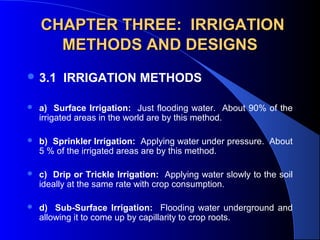
  • 1. CHAPTER THREE: IRRIGATION METHODS AND DESIGNS  3.1 IRRIGATION METHODS    a) Surface Irrigation:  Just flooding water.  About 90% of the  irrigated areas in the world are by this method.  b) Sprinkler Irrigation:  Applying water under pressure.  About  5 % of the irrigated areas are by this method.  c) Drip or Trickle Irrigation:  Applying water slowly to the soil  ideally at the same rate with crop consumption.  d) Sub-Surface Irrigation:    Flooding  water  underground  and  allowing it to come up by capillarity to crop roots.
  • 2. 3.2 SURFACE IRRIGATION      Water is applied to the field in either the controlled or  uncontrolled manner. Controlled:    Water  is  applied  from  the  head  ditch  and  guided  by  corrugations,  furrows,  borders,  or  ridges. Uncontrolled:  Wild flooding. Surface irrigation is entirely practised where water is  abundant.  The low initial cost of development is later  offset by high labour cost of applying water.  There  are deep percolation, runoff and drainage problems
  • 3. 3.2.1 Furrow Irrigation  In  furrow  irrigation,  only  a  part  of  the  land  surface (the furrow) is wetted thus minimizing  evaporation loss.    Furrow irrigation is adapted for row crops like  corn,  banana,  tobacco,  and  cabbage.    It  is  also good for grains.     Irrigation  can  be  by  corrugation  using  small  irrigation streams.    Furrow  irrigation  is  adapted  for  irrigating  on  various slopes except on steep ones because  of erosion and bank overflow.
  • 4. Furrow Irrigation Contd.       There are different ways of applying water to the furrow.   As shown in Fig. 3.1, siphons are used to divert water from the  head ditch to the furrows.   There can also be direct gravity flow whereby water is delivered  from the head ditch to the furrows by cutting the ridge or levee  separating  the  head  ditch  and  the  furrows  (see  diagram  from  Gumb's book).   Gated  pipes  can  also  be  used.    Large  portable  pipe(up  to  450  mm) with  gate openings spaced  to  deliver water to the furrows  are used.   Water is pumped from the water source in closed conduits.   The openings of the gated pipe can be regulated to control the  discharge rate into the furrows.
  • 8. 3.2.1.1 Design Parameters of Furrow Irrigation  The Major Design Considerations in Surface Irrigation Include:  Storing  the  Readily  Available  Moisture  in  the  Root  Zone,  if    Possible;  Obtaining As Uniform Water Application As Possible;  Minimizing Soil Erosion by Applying Non-erosive Streams;  Minimizing Runoff at the End of the Furrow by Using a Re-use  System or a Cut -Back Stream;  Minimizing  Labour  Requirements  by  Having  Good  Land  Preparation,  Good Design and Experienced Labour and  Facilitating  Use  of  Machinery  for  Land  Preparation,  Cultivation,  Furrowing, Harvesting Etc.      
  • 9. Furrow Irrigation Contd.  The  Specific  Design  Parameters  of  Furrow  Irrigation  Are  Aimed  at  Achieving  the  Above  Objectives and Include:  a) Shape and Spacing of Furrows:  Heights  of ridges vary between 15 cm and 40 cm and  the  distance  between  the  ridges  should  be  based on the optimum crop spacing modified,  if  necessary  to  obtain  adequate  lateral  wetting,  and  to  accommodate  the  track  of  mechanical equipment.    The range of spacing commonly used is from  0.3 to 1.8 m with 1.0 m as the average.
  • 10. Design Parameters of Furrow  Irrigation Contd.  b) Selection of the Advance or Initial Furrow Stream:  In  permeable  soils,  the  maximum  non-erosive  flow  within  the  furrow  capacity can be used so as to enable wetting  of  the  end  of  the  furrow  to  begin  as  soon  as  possible.    The  maximum  non-erosive  flow  (Qm)  is  given  by:   Qm  =  c/S    where c is a constant  =  0.6  when Qm is in l/s and S is slope in  %.  Example 1:  For a soil slope of 0.1 %, the Qm 
  • 11. Design Parameters of Furrow  Irrigation Contd.      The actual stream size should be determined by field  tests.   It is desirable that this initial stream size reaches the  end of the furrow in T/4 time where T is the total time  required to apply the required irrigation depth. c) Cut-back Stream:  This is the stream size to  which the initial stream is reduced sometime after it  has reached the lower end of the field.   This is to reduce soil erosion.   One or two cutbacks can be carried out and removing  some siphons or reducing the size at the head of the  furrow achieves this.
  • 12. Design Parameters of Furrow  Irrigation Contd.  d) Field Slope: To  reduce  costs  of  land  grading, longitudinal and cross slopes should  be adapted to the natural topography.    Small cross slopes can be tolerated.     To  reduce  erosion  problems  during  rainfall,  furrows  (which  channel  the  runoff)  should  have a limited slope (see Table 3.1).  
  • 13. Table 3.1 : Maximum Slopes for Various Soil Types Soil Type Maximum slopes*     Sand                                            0.25     Sandy loam           0.40     Fine sandy loam                     0.50     Clay                                              2.50     Loam            6.25                Source: Withers & Vipond (1974)  *A minimum slope of about 0.05 % is required  to ensure surface drainage.
  • 14. Design Parameters of Furrow  Irrigation Contd.  e) Furrow Length: Very  long  lengths  lead  to  a  lot  of  deep  percolation  involving  over-irrigation  at  the  upper  end of the furrow and under-irrigation at  the lower end.    Typical  values  are  given  in  Table  3.2,    but  actual furrow lengths  should  be  got  from field tests.
  • 15.
  • 16.  
  • 17. Design Parameters of Furrow  Irrigation Contd.  e) Field Widths:    Widths  are  flexible  but  should  not  be  of  a  size  to  enclose  variable soil types.    The  widths  should  depend  on  land  grading permissible.
  • 18. 3.2.1.2 Evaluation of a Furrow Irrigation System  The objective is to determine fairly accurately  how  the  system  is  used  and  to  suggest  possible amendments or changes.  Equipment:  Engineers Level and Staff,   30 m Tape,   Marker Stakes,   Siphons of Various Sizes,   Two Small Measuring Flumes,   Watch with Second Hand and Spade.
  • 19. Evaluation of a Furrow Irrigation System Contd.  Procedure       a)    Select  several  (say  3  or  more)  uniform  test  furrows  which  should be typical of those in the area. b)    Measure  the  average  furrow  spacing  and  note  the  shape,  condition etc. c)  Set the marker stakes at 30 m intervals down the furrows. d)  Take levels at each stake and determine the average slope. e)    Set  the  flumes  say  30  m  apart  at  the  head  of  the  middle  furrow. f)    Pass  constant  flow  streams  down  the  furrows,  using  wide  range of flows.  The largest flow should just cause erosion and  overtopping, the smallest might just reach the end of the furrow.   The median stream should have a discharge of about  Q  =  3/4  S (l/s)  where S is the % slope.
  • 20. Evaluation of a Furrow Irrigation  System Contd.  g)    Record  the  time  when  flow  starts  and  passes  each  marker  in  each     flow(advance data). h)    Record  the  flow  at  each  flume  periodically  until  the  flows  become  practically  constant.    This  may  take  several  hours  on  fine  textured  soils(Infiltration data). i)  Check for evidence of erosion or overtopping. j)  Move the flumes and measure the streams at the heads only of the other  furrows.   Results:  To be presented in a format shown: ............................................................................................................ Watch           Opportunity time(mins)                                                                              Station A          Station B                  Losses  Time                A        B              C           Depth   Flow     Depth    Flow      Diff      Infil.                                                                 (mm)   ( L/s)       (mm)     (L/s)     (L/s)   (mm/h) ..............................................................................................................         
  • 21. 3.2.2. Border Irrigation System    In  a  border  irrigation,  controlled  surface  flooding  is     practised whereby the field is divided up into strips by  parallel  ridges  or  dykes  and  each  strip  is  irrigated  separately  by  introducing  water  upstream  and  it  progressively covers the entire strip. Border irrigation is suited for crops that can withstand  flooding for a short time e.g. wheat.   It can be used for all crops provided that the system  is designated to provide the needed water control for  irrigation of crops.   It  is  suited  to  soils  between  extremely  high  and  very  low infiltration rates.
  • 24. Border Irrigation Contd.  In border irrigation, water is applied slowly.    The  root  zone  is  applied  water  gradually  down the field.    At  a  time,  the  application  flow  is  cut-off  to  reduce water loses.    Ideally,  there  is  no  runoff  and  deep  percolation.    The  problem  is  that  the  time  to  cut  off  the  inflow is difficult to determine.
  • 25. 3.2.2.2 Design Parameters of Border Irrigation System       a) Strip width: Cross slopes must be eliminated by leveling. Since there are no furrows to restrict lateral movement, any cross slope will make water move down one side leading to poor application efficiency and possibly erosion. The stream size available should also be considered in choosing a strip width. The size should be enough to allow complete lateral spreading throughout the length of the strip. The width of the strip for a given water supply is a function of the length (Table 3.5). The strip width should be at least bigger than the size of vehicle tract for construction where applicable.
  • 26. Design Parameters of Border Irrigation System Contd.     b) Strip Slope: Longitudinal slopes should be almost same as for the furrow irrigation. c) Construction of Levees: Levees should be big enough to withstand erosion, and of sufficient height to contain the irrigation stream. d) Selection of the Advance Stream: The maximum advance stream used should be non-erosive and therefore depends on the protection afforded by the crop cover. Clay soils are less susceptible to erosion but suffer surface panning at high water velocities. Table 3.4 gives the maximum flows recommendable for bare soils. e) The Length of the Strip: Typical lengths and widths for various flows are given in Table 3.5. The ideal lengths can be obtained by field tests.
  • 27.
  • 28.
  • 29. 3.2.2.3 Evaluation of a Border Strip    The aim is to vary various parameters with the aim of obtaining a good irrigation profile. Steps a) Measure the infiltration rate of soils and get the cumulative infiltration curve. Measurement can be by double ring infiltrometer. Depth of Water, D (mm) D = KTn Time, T (mins) Fig 3.5: Cumulative Infiltration Curve
  • 30. Evaluation of Border Strip Contd.  b) Mark some points on the border strip and check the advance of water. Also check recession. For steep slopes, recession of water can be seen unlike in gentle slopes where it may be difficult to see. In border irrigation, recession is very important because unlike furrows, there is no place water can seep into after water is turned off.
  • 31. Time Distance Diagram of the Border System
  • 32. Evaluation of the Border System Contd.     About two-thirds down the border, the flow is turned off and recession starts. The difference between the advance and recession curves gives the opportunity time or total time when water is in contact with the soil. For various distances, obtain the opportunity times from the advance/recession curves and from the cumulative infiltration curve, obtain the depths of water. With the depth and distance data, plot the irrigation profile depth shown below.
  • 33. Depth- Distance Diagram of the Border System
  • 34. Evaluation of the Border System Contd.      The depth of irrigation obtained is compared with the SMD (ideal irrigation depth). There is deep percolation and runoff at the end of the field. The variables can then be changed to give different shapes of graphs to see the one to reduce runoff and deep percolation. In this particular case above, the inflow can be stopped sooner. The recession curve then changes. The profile now obtained creates deficiency at the ends of the borders (see graph: dotted lies above). A good profile of irrigation can be obtained by varying the flow, which leads to a change in the recession curve, and by choosing a reasonable contact time each time using the infiltration curve.
  • 35. 3.2.3 Basin Irrigation System       3.2.3.1 Description: In basin irrigation, water is flooded in wider areas. It is ideal for irrigating rice. The area is normally flat. In basin irrigation, a very high stream size is introduced into the basin so that rapid movement of water is obtained. Water does not infiltrate a lot initially. At the end, a bond is put and water can pond the field. The opportunity time difference between the upward and the downward ends are reduced.
  • 37. 3.2.3.2 Size of Basins  The size of basin is related to stream size and soil type(See Table 3.6 below).  Table 3.6: Suggested basin areas for different soil types and rates of water flow Flow rate Soil Type Sand Sandy loam Clay loam Clay l/s m3 /hr .................Hectares................................ 30 108 0.02 0.06 0.12 0.20 60 216 0.04 0.12 0.24 0.40 90 324 0.06 0.18 0.36 0.60 120 432 0.08 0.24 0.48 0.80 150 540 0.10 0.30 0.60 1.00 180 648 0.12 0.36 0.72 1.20 210 756 0.14 0.42 0.84 1.40 240 864 0.16 0.48 0.96 1.60 300 1080 0.20 0.60 1.20 2.00 ........................................................................................... Note: The size of basin for clays is 10 times that of sand as the infiltration rate for clay is low leading to higher irrigation time. The size of basin also increases as the flow rate increases. The table is only a guide and practical values from an area should be relied upon. There is the need for field evaluation.              
  • 38. 3.2.3.3 Evaluation of Basin System  a) Calculate the soil moisture deficiency and irrigation depth.  b) Get the cumulative infiltration using either single or double ring infiltrometer . I = c Tn Infiltered Depth (mm) Time (mins)
  • 39. Evaluation of a Basin System Contd.  c) Get the advance curves using sticks to monitor rate of water movement. Plot a time versus distance graph (advance curve). Also plot recession curve or assume it to be straight  It is ensured that water reaches the end of the basin at T/4 time and stays T time before it disappears. At any point on the advance and recession curves, get the contact or opportunity time and relate it to the depth-time graph above to know the amount of water that has infiltrated at any distance.
  • 40. Time-Distance Graph of the Basin System
  • 41. Depth-Distance Graphs of the Basin Irrigation System
  • 42. Evaluation of Basin Irrigation Concluded.  Check the deficiency and decide whether improvements are necessary or not. The T/4 time can be increased or flow rate changed. The recession curve may not be a straight line but a curve due to some low points in the basin.
  • 43. 3.3 SPRINKLER IRRIGATION      3.3.1 Introduction: The sprinkler system is ideal in areas where water is scarce. A Sprinkler system conveys water through pipes and applies it with a minimum amount of losses. Water is applied in form of sprays sometimes simulating natural rainfall. The difference is that this rainfall can be controlled in duration and intensity. If well planned, designed and operated, it can be used in sloping land to reduce erosion where other systems are not possible.
  • 44. Components of a Sprinkler Irrigation System
  • 45. 3.3.2 Types of Conventional Sprinkler Systems      a) Fully portable system: The laterals, mains, sub-mains and the pumping plant are all portable. The system is designed to be moved from one field to another or other pumping sites that are in the same field. b) Semi-portable system: Water source and pumping plant are fixed in locations. Other components can be moved. The system cannot be moved from field to field or from farm to farm except when more than one fixed pumping plant is used.
  • 46. Types of Conventional Sprinkler Systems Contd.      c) Fully permanent system: Permanent laterals, mains, sub-mains as well as fixed pumping plant. Sometimes laterals and mainlines may be buried. The sprinkler may be permanently located or moved along the lateral. It can be used on permanent irrigation fields and for relatively high value crops e.g. Orchards and vineyards. Labour savings throughout the life of the system may later offset high installation cost.
  • 47. 3.3.3 Mobile Sprinkler Types  a) Raingun: A mobile machine with a big sprinkler.  The speed of the machine determines the application rate. The sprinkler has a powerful jet system.  b) Lateral Move: A mobile long boom with many sprinklers attached to them.  As the machine moves, it collects water from a canal into the sprinklers connected to the long boom.
  • 50. Centre Pivot  c) Centre Pivot: The source of water is stationary e.g. a bore hole. The boom with many sprinklers rotates about the water source.
  • 52. Pivot of a Centre Pivot System
  • 53. 3.3.4 Design of Sprinkler Irrigation System  Objectives and Procedures  Provide Sufficient Flow Capacity to meet the Irrigation Demand  Ensure that the Least Irrigated Plant receives adequate Water  Ensure Uniform Distribution of Water.
  • 54. Design Steps  Determine Irrigation Water Requirements and Irrigation Schedule  Determine Type and Spacing of Sprinklers  Prepare Layout of Mainline, Submains and Laterals  Design Pipework and select Valves and Fittings  Determine Pumping Requirements.
  • 55. Choice of Sprinkler System  Consider:  Application rate or precipitation rate  Uniformity of Application: Use UC  Drop Size Distribution and  Cost
  • 56. Sprinkler Application Rate  Must be Less than Intake Rates Soil Texture Max. Appln. Rates (mm/hr.) Coarse Sand 20 to 40 Fine Sand 12 to 25 Sandy Loam 12 Silt Loam 10 Clay Loam/Clay 5 to 8
  • 57. Effects of Wind  In case of Wind:  Reduce the spacing between Sprinklers: See table 6 in Text.  Allign Sprinkler Laterals across prevailing wind directions  Build Extra Capacity  Select Rotary Sprinklers with a low trajectory angle.
  • 58. System Layout  Layout is determined by the Physical Features of the Site e.g. Field Shape and Size, Obstacles, and topography and the type of Equipment chosen.  Where there are several possibilities of preparing the layout, a cost criteria can be applied to the alternatives.  Laterals should be as long as site dimensions, pressure and pipe diameter restrictions will allow.  Laterals of 75 mm to 100 mm diameter can easily be moved.  Etc. - See text for other considerations
  • 59. Pipework Design  This involves the Selection of Pipe Sizes to ensure that adequate water can be distributed as uniformly as possible throughout the system  Pressure variations in the system are kept as low as possible as any changes in pressure may affect the discharge at the sprinklers
  • 60. Design of Laterals  Laterals supply water to the Sprinklers  Pipe Sizes are chosen to minimize the pressure variations along the Lateral, due to Friction and Elevation Changes.  Select a Pipe Size which limits the total pressure change to 20% of the design operating pressure of the Sprinkler.  This limits overall variations in Sprinkler Discharge to 10%.
  • 61. Lateral Discharge  The Discharge (QL) in a Lateral is defined as the flow at the head of the lateral where water is taken from the mainline or submain.  Thus: QL = N. qL Where N is the number of sprinklers on the lateral and qL is the Sprinkler discharge (m3/h)
  • 62. Selecting Lateral Pipe Sizes  Friction Loss in a Lateral is less than that in a Pipeline where all the flow passes through the entire pipe Length because flow changes at every sprinkler along the Line.  First Compute the Friction Loss in the Pipe assuming no Sprinklers using a Friction Formula or Charts and then:  Apply a Factor, F based on the number of Sprinklers on the Lateral (See Text for F Values)
  • 63. Selecting Lateral Pipe Sizes Contd.  Lateral Pipe Size can be determined as follows:  Calculate 20% of Sprinkler Operating Pressure (Pa)  Divide Value by F for the number of Sprinklers to obtain Allowable Pressure Loss (Pf)  Use Normal Pipeline Head Loss Charts of Friction Formulae with Calculated Pf and QL to determine Pipe Diameter, D.
  • 64. Changes in Ground Elevation  Allowance must be made for Pressure changes along the Lateral when it is uphill, downhill or over undulating land.  If Pe1 is the Pressure Difference Due to Elevation changes: Pf = Pf = 0.2 Pa − PeL F 0.2 Pa + PeL F for laterals laid uphill for laterals laid downhill
  • 65. Pressure at Head of Lateral  The Pressure requirements (PL)where the Lateral joins the Mainline or Submain are determined as follows:  PL = Pa + 0.75 Pf + Pr For laterals laid on Flat land  PL = Pa + 0.75 (Pf ±Pe) + Pr For Laterals on gradient.  The factor 0.75 is to provide for average operating pressure (Pa) at the centre of the Lateral rather than at the distal end. Pr is the height of the riser.
  • 66. Diagram of Pressure at Head of Lateral
  • 67. Selecting Pipe Sizes of Submains and MainLines  As a general rule, for pumped systems, the Maximum Pressure Loss in both Mainlines and Submains should not exceed 30% of the total pumping head required.  This is reasonable starting point for the preliminary design.  Allowance should be made for pressure changes in the mainline and submain when they are uphill, downhill or undulating.
  • 68. Pumping Requirements  Maximum Discharge (Qp) = qs N Where:  qs is the Sprinkler Discharge and N is the total number of Sprinklers operating at one time during irrigation cycle.  The Maximum Pressure to operate the system (Total Dynamic Head, Pp) is given as shown in Example.
  • 69. 3.4 DRIP OR TRICKLE IRRIGATION         3.4.1 Introduction: In this irrigation system: i) Water is applied directly to the crop ie. entire field is not wetted. ii) Water is conserved (iii) Weeds are controlled because only the places getting water can grow weeds. (iv) There is a low pressure system. (v) There is a slow rate of water application somewhat matching the consumptive use. Application rate can be as low as 1 - 12 l/hr. (vi) There is reduced evaporation, only potential transpiration is considered. vii) There is no need for a drainage system.
  • 70. Components of a Drip Irrigation System Control Head Unit Wetting Pattern Mainline Or Manifold Emitter Lateral
  • 71. Drip Irrigation System  The Major Components of a Drip Irrigation System include:  a) Head unit which contains filters to remove debris that may block emitters; fertilizer tank; water meter; and pressure regulator.  b) Mainline, Laterals, and Emitters which can be easily blocked.
  • 72. 3.4.2 Water Use for Trickle Irrigation System  The design of drip system is similar to that of the sprinkler system except that the spacing of emitters is much less than that of sprinklers and that water must be filtered and treated to prevent blockage of emitters.  Another major difference is that not all areas are irrigated.  In design, the water use rate or the area irrigated may be decreased to account for this reduced area.
  • 73. Water Use for Trickle Irrigation System Contd.    Karmeli and Keller (1975) suggested the following water use rate for trickle irrigation design ETt = ET x P/85       Where: ETt is average evapotranspiration rate for crops under trickle irrigation; P is the percentage of the total area shaded by crops; ET is the conventional evapotranspiration rate for the crop. E.g. If a mature orchard shades 70% of the area and the conventional ET is 7 mm/day, the trickle irrigation design rate is: 7/1 x 70/85 = 5.8 mm/day OR use potential transpiration, Tp = 0.7 Epan where Epan is the evaporation from the United States Class A pan.
  • 74. Emitters Consist of fixed type and variable size types. The fixed size emitters do not have a mechanism to compensate for the friction induced pressure drop along the lateral while the variable size types have it.  Emitter discharge may be described by:  q = Khx  Where: q is the emitter discharge; K is constant for each emitter ; h is pressure head at which the emitter operates and x is the exponent characterized by the flow regime. 
  • 75. Emitters Contd.  The exponent, x can be determined by measuring the slope of the log-log plot of head Vs discharge.  With x known, K can be determined using the above equation.  Discharges are normally determined from the manufacturer's charts (see Fig. 3.7 in Note). 
  • 76. 3.4.4       Water Distribution from Emitters Emitter discharge variability is greater than that of sprinkler nozzles because of smaller openings(lower flow) and lower design pressures. Eu = 1 - (0.8 Cv/ n 0.5 ) Where Eu is emitter uniformity; Cv is manufacturer's coefficient of variation(s/x ); n is the number of emitters per plant. Application efficiency for trickle irrigation is defined as: Eea = Eu x Ea x 100 Where Eea is the trickle irrigation efficiency; Ea is the application efficiency as defined earlier.
  • 77. 3.4.5    Trickle System Design The diameter of the lateral should be selected so that the difference in discharge between emitters operating simultaneously will not exceed 10 %. This allowable variation is same as for sprinkler irrigation laterals already discussed. To stay within this 10 % variation in flow, the head difference between emitters should not exceed 10 to 15 % of the average operating head for long-path or 20 % for turbulent flow emitters.
  • 78. Trickle System Design Contd.  The maximum difference in pressure is the head loss between the control point at the inlet and the pressure at the emitter farthest from the inlet.  The inlet is usually at the manifold where the pressure is regulated.  The manifold is a line to which the trickle laterals are connected.
  • 79. Trickle System Design Contd.  For minimum cost, on a level area 55 % of the allowable head loss should be allocated to the lateral and 45 % to the manifold. The Friction Loss for Mains and Sub-mains can be computed from Darcy-Weisbach equation for smooth pipes in trickle systems when combined with the Blasius equation for friction factor. The equation is: Hf = K L Q 1.75 D – 4.75  Where: Hf is the friction loss in m;  K is constant = 7.89 x 10⁵ for S.I. units for water at 20 ° C; L is the pipe length in m; Q is the total pipe flow in l/s; and D is the internal diameter of pipe in mm.      
  • 80. Trickle System Design Contd  As with sprinkler design, F should be used to compute head loss for laterals and manifolds with multiple outlets, by multiplying a suitable F factor  (See Table 8 of Sprinkler Design section) by head loss.  F values shown below can also be used.
  • 81. Table 3.7: Correction Factor, F for Friction Losses in Aluminium Pipes with Multiple Outlets.            Number of Outlets F* 1 1.00 2 0.51 4 0.41 6 0.38 8 0.37 12 0.36 16 0.36 20 0.35 30 or more 0.35 *Values adapted from Jensen and Frantini (1957
  • 82. Example  Design a Trickle Irrigation System for a fully matured orchard with the layout below. Assume that the field is level, maximum time for irrigation is 12 hours per day, allowable pressure variation in the emitters is 15%, the maximum suction lift at the well is 20 m, the ET rate is 7 mm/day and the matured orchard shades 70% of the area; trickle irrigation efficiency is 80%. Sections 1 and 2 are to be irrigated at the same time and alternated with sections 3 and 4. Each tree is to be supplied by 4 emitters.
  • 83. LAYOUT OF THE TRICKLE IRRIGATION SYSTEM
  • 84. Solution  (1) ETt = ET x P/85  Where: Ett is the average ET for crops under trickle irrigation (mm/day)  ET is nomal ET rate for the crop = 7 mm/day  P is the percentage of total ares shaded by the crop = 70%  ETt = 7 mm/day x 70/85 = 5.8 mm/day.
  • 85. Solution Contd.  (2) Discharge for each tree with a spacing of 4 m x 7 m        = 4 m x 7 m x 5.8 x 10-3 m/day = 0.162 m3/day = 0.00675 m3/hr (24 hr. day) For 12 hours of opearation per day, discharge required = 0.00675 x 24/12 = 0.0135 m3/hr = 0.00375 L/s With an appliance efficiency of 80%, the required discharge per tree is: 0.00375/0.8 = 0.0047 L/s The discharge per emitter, with 4 emitters per tree is then: = 0.0047/4 = 0.00118 L/s = 0.0012 L/s
  • 86. Discharge of Each Line Line No. of Trees No. of Emitters Required Discharge (L/s) Half Lateral 12 48 0.0576 Half Manifold 168 672 0.8060 Submain, A to Section 1 336 1344 1.6130 Main, A to Pump 672 2688 3.2260
  • 87. Solution Contd.  (4) From Fig. 21.6 (Soil and Water Conservation), select the medium long-path emitter with K = 0.000073 and x = 0.63  Substituting in equation q = K h x, with an average discharge of 0.0012 L/s,  Log q = log K + x log h Log h = Log q − Log K Log 0.0012 − Log 0.000073 = x 0.63 h = 87 kPa or 8.9 m ( or use Chart to obtain h). This is the Average operating head, Ha.
  • 88. Solution Contd.  (5) Total allowable pressure loss of 15 % of Ha in both the Lateral and Manifold = 8.9 x 0.15 =1.3 m of which 0.55 x 1.3 = 0.7 m is allowed for Lateral and 0.45 x 1.3 = 0.6 is for the Manifold.  (6) Compute the Friction Loss in each of the Lines from Equation:  Hf = K L Q 1.75 D –4.75 by selecting a diameter to keep the loss within the allowable limits of 0.7 m and 0.6 m, already determined.
  • 89. Selection of Diameters Line Q (L/s) Pipe Diameter (mm) L (m) F Hf’ (m) Half Lateral 0.0576 12.70 46 0.36 0.51 Half Manifold 0.8060 31.75 45.5 0.36 0.68 Sub-Main, A to Section 1 1.6130 44.45 243 1 6.59 Main, A to 3.2260 Pump 50.80 60 1 2.90
  • 90. Pressure Head at Manifold Inlet  Like Sprinklers, the pressure head at inlet to the manifold:  = Average Operating Head = 8.9 m  + 75% of Lateral and Manifold head Loss = 0.75 (0.51 + 0.68)  + Riser Height = Zero for Trickle since no risers exist.  + Elevation difference = Zero , since the field is Level  = 9.79 m
  • 91. Solution Concluded  Total Head for Pump  = Manifold Pressure = 9.79 m  + Pressure loss at Sub-main = 6.59 m  + Pressure loss at Main = 2.90 m  + Suction Lift = 20 m  + Net Positive Suction head for pump = 4 m (assumed)  = 43.28 m  i.e. The Pump must deliver 3.23 L/s at a head of about 43 m.
  • 92. 3.5 SUB-SURFACE IRRIGATION  Applied in places where natural soil and topographic condition favour water application to the soil under the surface, a practice called sub-surface irrigation. These conditions include:  a) Impervious layer at 15 cm depth or more  b) Pervious soil underlying the restricting layer.  c) Uniform topographic condition  d) Moderate slopes.
  • 93. SUB-SURFACE IRRIGATION Contd.  The operation of the system involves a huge reservoir of water and level is controlled by inflow and outflow.  The inflow is water application and rainfall while the outflow is evapotranspiration and deep percolation.  It does not disturb normal farm operations. Excess water can be removed by pumping.
  • 94. 3.6 CHOICE OF IRRIGATION METHODS:  The following criteria should be considered:  (a) Water supply available  (b) Topography of area to be irrigated  c) Climate of the area  (d) Soils of the area  (e) Crops to be grown  f) Economics  (g) Local traditions and skills  (For details see extract from Hudson's Field Engineering).
  • 95. 3.7 INFORMATION TO BE COLLECTED ON A VISIT TO A PROPOSED IRRIGATION SITE.    a) Soil Properties: Texture and structure, moisture equilibrium points, water holding capacity, agricultural potential, land classification, kinds of crops that the soil can support. b) Water Source: Water source availability eg. surface water, boreholes etc., hydrologic data of the area, water quantity, water quality, eg. sodium adsorption ratio, salt content, boron etc.; possible engineering works necessary to obtain water. c) Weather data: Temperature, relative humidity, sunshine hours and rainfall.
  • 96. INFORMATION TO BE COLLECTED  d) Topography e.g. slope: This helps to determine the layout of the irrigation system and method of irrigation water application suited for the area.  e) History of People and Irrigation in the area: Check past exposure of people to irrigation and land tenure and level of possible re-settlement or otherwise.  f) Information about crops grown in the area: Check preference by people, market potential, adaptability to area, water demand, growth schedules and planting periods.

Hinweis der Redaktion

  1. Solve problem in note.