

Empfohlen
Weitere ähnliche Inhalte
Was ist angesagt?
Was ist angesagt? (19)
Andere mochten auch
Andere mochten auch (20)
Ähnlich wie Global positioning system
Ähnlich wie Global positioning system (20)
Mehr von Naveen Sihag
Mehr von Naveen Sihag (20)
Kürzlich hochgeladen
Kürzlich hochgeladen (20)
Global positioning system
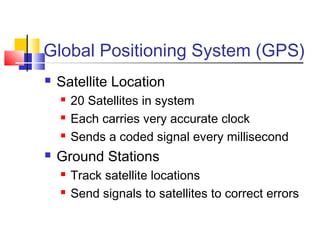
- 1. Global Positioning System (GPS) Satellite Location 20 Satellites in system Each carries very accurate clock Sends a coded signal every millisecond Ground Stations Track satellite locations Send signals to satellites to correct errors
- 2. Local Receivers Generate same signals as satellite Compare differences to determine distance to satellite Clocks not nearly as accurate Some errors occur
- 3. GPS Location Location found by comparing signals Time Difference x Light Speed = Distance Clocks accurate to nanosecond (1 x 10⁻⁹ s) Accuracy = (186,282 mi/s)(5280 ft/mi)(1 x 10-9 s) = 0.984 ft How do we locate to the cm?
- 4. Multiple Satellites One – distance only Two – point falls on a circle Three – one of two points 4 or more – average to eliminate error
- 5. Who Uses GPS? Surveyors Military Agriculture Railroads Corporate fleets Auto Security
- 6. Where Are We? Longitude Starts at Greenwich 180° E or W Longitude Starts at Equator 90° N or S Moorhead N 46°52’ Latitude, W 96°45’ Longitude
- 7. Convert to Grid Projections Lambert’s Conformal Transverse Mercator GPS uses UTM Error limited to 1:10,000 Computer models convert Lat, Long to universal grid
- 8. Sources of Error Atmospheric Built-in Compensation Receivers More satellites, better averaging Selective Availability Intentional Error – DOD Same error at any given time Eliminate by differential positioning
- 9. Relative Positioning Dynamic Two receivers, one set over known Both collect data over time Computer determines correction after Real-time Kinetic Permanent receiver over know Transmit real-time corrections to field Farmers, transit authorities
- 10. PDOP Position Dilution of Precision Numeric scale indicating precision Depends on position, number of satellites Satellite alignment could limit precision PDOP = 1: Best precision PDOP = 5: Very poor – try later