SlideShare ist ein Scribd-Unternehmen logo
1 von 1
Dissemination:
• Online reports, damage-assessment blogs, and Facebook as
well as other social media avenues are all used for
dissemination in the event the group is activated for a natural
hazard.
• Following a damage assessment the data collected is then
used to create a spatial data set of rated photos which are
then mapped in GIS (Fig. 5) and publish to the Web
immediately
• The results are documented in a final report and made
available to the public through journals and conferences.
• Whether a damage survey is conducted or not preliminary
reports of significant tornado damage are provided to
engineers, educational institutions, and individuals within
the wind hazard research community and are available at
Windhazard.DavidOPrevatt.com (Fig. 6).
Wind Damage Assessment & Training at the University of Florida
Jeandona Doreste1, David O. Prevatt, PE2, David Roueche3
1Undergraduate Student, 2Associate Professor, 3Graduate Student
Engineering School of Sustainable Infrastructure and Environment, 365 Weil Hall, University of Florida, Gainesville, FL 32611
OBJECTIVES
The Wind Hazard Damage Assessment Group was
formed in January 2012 as part of Dr. David O. Prevatt’s
National Science Foundation CAREER award.
The main goals of this group includes:
• Training students at the University of Florida in the
use of forensic engineering to understand the specific
causes of building failures in high winds
• Expose students to activities, techniques, and safety
involved in post-storm damage surveys
• Collect data and disseminate research findings on
sustainable residential construction practices.
METHOD
(1) Recruit interested students,
(2) Train them using both seminars and on-line training programs through
Windhazard.DavidOPrevatt.com,
(3) Assess wind damage, either in person or from a distance using social
media and available reports,
(4) Train in using wind speed towers, measuring wind velocity at 5 and 10-
meters, and 5-m satellite tower systems used in analysis of the lateral size
of gusts winds (Fig. 2 & 3) in conjunction with the Florida Coastal
Monitoring Program.
Preliminary Reports:
Upon becoming aware of significant damage to residential wood famed
buildings due to a tornado, within 24 to 48 hours, an online preliminary
forensic investigation report is prepared using information obtained from the
NWS offices, news reports, and social media.
Deployment:
The decision to deploy depends upon the significance of the tornado and the
potential for a detailed assessment to advance our current knowledge of wind
effects and building performance. If a deployment is warranted, the team arrives on
site as early as possible (typically within a week) to systematically collect
engineering data, consisting of handwritten notes and geo-tagged photographs.
Enhanced Fujita Scale:
• Photos are rated depending on level of damage intensity using the Enhanced
Fujita (EF) scale from EF0 with winds between 65-85 mph to EF5 with
winds between 200-234 mph
• The EF scale correlates damage to estimated wind speeds for 28 identified
damage indicators
• Each damage indicator has different degrees of damage associated with an
expected wind speed, including lower bound and upper bound speeds.
AKNOWLEDGEMENTS
The Wind Hazard Damage Assessment Team was created
through support from the NSF Award #1150975.
Figure 1: Operating PNE device
INTRODUCTION
From 1993 to 2012, tornadoes have accounted for 36% of
all insured catastrophic losses due to natural or man-
made disasters (Fig. 1). This figure amounts to a total of
$140.9 billion in losses over that 19-year span, resulting
mainly from damage and reparations to residential
structures. With the increase of the population density in
tornado-prone regions, the share of catastrophic losses
due to tornadoes will continue to rise.
The prevailing assumption has been that residential
structures cannot be designed to resist tornado level
winds. This is evidenced by the overwhelming number of
post-tornado damage surveys documenting decades of
catastrophic tornado loses to poorly engineered and aged
homes, built before stronger building codes. States in
tornado and hurricane-prone regions that have pushed for
the development of more wind-resistant structures
provide great opportunities to validate whether this
assumption is true.
RESULTS
• In the past two years, the Wind Hazard Damage Assessment Group has
grown to 20 members
• Five online preliminary reports have been written and disseminated to
over 500 stakeholders via the website, email, and social media.
• The team has surveyed damage after three Florida tornadoes and
actively monitors the occurrence of tornadoes nationwide.
• The most significant damage-assessment deployment was following
the May 20, 2013 Moore, Oklahoma EF-5 tornado, which created a
1.3 mile wide and 17-mile long damage path destroying over 12,000
buildings and killing 24 people.
Figure 1: U.S. Catastrophe Losses by Cause of Loss, 1993-2012
REFERENCES
Prevatt, D. O. (2011). Career: Tornado-resilient structural retrofits for sustainable housing
communities. Unpublished manuscript, Engineering School of Sustainable Infrastructure
and Environment, University of Florida, Gainesville, FL.
Hartwig, R. P. Insurance Information Institute, (2013). Overview & outlook for the p/c insurance
industry: Trends, challenges and opportunities. Retrieved from website:
http://www.iii.org/assets/docs/pdf/SWAF-120613.pdf
Figure 6: Wind Hazard Damage Assessment Website
Figure 2: Crew setting up wind speed
tower during hurricane Irene -2011
Figure 3: Wind speed (left) and satellite
tower system (right)
Figure 4: Moore OK damage assessment team surveying neighborhood with massive
progressive damage - 2013
Figure 5: GIS map of rated damage along Moore, OK tornado path, publicly
available at http://esridev.caps.ua.edu/mooretornado/mooretornado.html
FUTURE GOALS
• The Wind Hazard Damage Assessment Group hopes to inspire and
train engineering students in hopes to reduce, even marginally, the
trend of widespread catastrophic damage to houses due to tornadic
loads.
• The group recently joined the Weather Ready Nation initiative, a joint
endeavor between the National Oceanic Atmospheric Administration
(NOAA), National Weather Service and the Federal Emergency
Management Agency (FEMA).
• Goal of this partnership is to facilitate outreach to local communities
and serve as a platform to share new, creative solutions for hazard
resilient communities.
Figure 7: Locations of tornado surveys and preliminary reports

Weitere ähnliche Inhalte

Ähnlich wie Poster for Undergraduate Research Symposium February 27th, 2014

AI-Based Change Detection for Disaster Identification utilizing Bi- temporal ...
AI-Based Change Detection for Disaster Identification utilizing Bi- temporal ...AI-Based Change Detection for Disaster Identification utilizing Bi- temporal ...
AI-Based Change Detection for Disaster Identification utilizing Bi- temporal ...IRJET Journal
 
EXPLORE EARTH by John J. Murray | TROPICS Applications Workshop II, February ...
EXPLORE EARTH by John J. Murray | TROPICS Applications Workshop II, February ...EXPLORE EARTH by John J. Murray | TROPICS Applications Workshop II, February ...
EXPLORE EARTH by John J. Murray | TROPICS Applications Workshop II, February ...Helen Gynell
 
DISASTER PREDICTION
DISASTER PREDICTIONDISASTER PREDICTION
DISASTER PREDICTIONLibcorpio
 
An Overview of Advanced Techniques Used in Disaster Management
An Overview of Advanced Techniques Used in Disaster ManagementAn Overview of Advanced Techniques Used in Disaster Management
An Overview of Advanced Techniques Used in Disaster ManagementIRJET Journal
 
DISASTER MITIGATION AND MANAGEMENT INTRODUCTION
DISASTER MITIGATION AND MANAGEMENT INTRODUCTIONDISASTER MITIGATION AND MANAGEMENT INTRODUCTION
DISASTER MITIGATION AND MANAGEMENT INTRODUCTIONKavya Kusam
 
15 fa transportation-system_ws2015
15 fa transportation-system_ws201515 fa transportation-system_ws2015
15 fa transportation-system_ws2015Luca Marescotti
 
A 3D Visualization System For Hurricane Storm-Surge Flooding
A 3D Visualization System For Hurricane Storm-Surge FloodingA 3D Visualization System For Hurricane Storm-Surge Flooding
A 3D Visualization System For Hurricane Storm-Surge FloodingFelicia Clark
 
Wildfire Hazards
Wildfire HazardsWildfire Hazards
Wildfire Hazardsguest73b391
 
Hazards print_07192013
Hazards print_07192013Hazards print_07192013
Hazards print_07192013Sandy Justice
 
Lesson 5. Crisis Mapping and Community Drills
Lesson 5. Crisis Mapping and Community DrillsLesson 5. Crisis Mapping and Community Drills
Lesson 5. Crisis Mapping and Community Drillsgicait ait
 
SMART Seminar Series: "Infrastructure Resilience: Planning for Future Extreme...
SMART Seminar Series: "Infrastructure Resilience: Planning for Future Extreme...SMART Seminar Series: "Infrastructure Resilience: Planning for Future Extreme...
SMART Seminar Series: "Infrastructure Resilience: Planning for Future Extreme...SMART Infrastructure Facility
 
GE8071 Unit 5 - DISASTER MANAGEMENT FOR FWT.
GE8071 Unit 5 - DISASTER MANAGEMENT FOR FWT.GE8071 Unit 5 - DISASTER MANAGEMENT FOR FWT.
GE8071 Unit 5 - DISASTER MANAGEMENT FOR FWT.GogulPrasathRamachan1
 
1415 - Cheelo_UtilizationToolsWMO_11UFA
1415 - Cheelo_UtilizationToolsWMO_11UFA1415 - Cheelo_UtilizationToolsWMO_11UFA
1415 - Cheelo_UtilizationToolsWMO_11UFAGillie Cheelo
 
IRJET - A Case Study on Flood Risk Management
IRJET - A Case Study on Flood Risk ManagementIRJET - A Case Study on Flood Risk Management
IRJET - A Case Study on Flood Risk ManagementIRJET Journal
 
Grand Challenges for Disaster Reduction
Grand Challenges for Disaster ReductionGrand Challenges for Disaster Reduction
Grand Challenges for Disaster ReductionFrancisYee1
 
Natural Hazards & ROLE of satellite remote sensing
Natural Hazards & ROLE of satellite remote sensingNatural Hazards & ROLE of satellite remote sensing
Natural Hazards & ROLE of satellite remote sensingABU UMEER BANBHAN
 
Explanatory material of NIED Disaster Information Sharing System
Explanatory material of NIED Disaster Information Sharing SystemExplanatory material of NIED Disaster Information Sharing System
Explanatory material of NIED Disaster Information Sharing SystemTadashi Ise
 

Ähnlich wie Poster for Undergraduate Research Symposium February 27th, 2014 (20)

AI-Based Change Detection for Disaster Identification utilizing Bi- temporal ...
AI-Based Change Detection for Disaster Identification utilizing Bi- temporal ...AI-Based Change Detection for Disaster Identification utilizing Bi- temporal ...
AI-Based Change Detection for Disaster Identification utilizing Bi- temporal ...
 
EXPLORE EARTH by John J. Murray | TROPICS Applications Workshop II, February ...
EXPLORE EARTH by John J. Murray | TROPICS Applications Workshop II, February ...EXPLORE EARTH by John J. Murray | TROPICS Applications Workshop II, February ...
EXPLORE EARTH by John J. Murray | TROPICS Applications Workshop II, February ...
 
DISASTER PREDICTION
DISASTER PREDICTIONDISASTER PREDICTION
DISASTER PREDICTION
 
An Overview of Advanced Techniques Used in Disaster Management
An Overview of Advanced Techniques Used in Disaster ManagementAn Overview of Advanced Techniques Used in Disaster Management
An Overview of Advanced Techniques Used in Disaster Management
 
DISASTER MITIGATION AND MANAGEMENT INTRODUCTION
DISASTER MITIGATION AND MANAGEMENT INTRODUCTIONDISASTER MITIGATION AND MANAGEMENT INTRODUCTION
DISASTER MITIGATION AND MANAGEMENT INTRODUCTION
 
15 fa transportation-system_ws2015
15 fa transportation-system_ws201515 fa transportation-system_ws2015
15 fa transportation-system_ws2015
 
A 3D Visualization System For Hurricane Storm-Surge Flooding
A 3D Visualization System For Hurricane Storm-Surge FloodingA 3D Visualization System For Hurricane Storm-Surge Flooding
A 3D Visualization System For Hurricane Storm-Surge Flooding
 
Wildfire Hazards
Wildfire HazardsWildfire Hazards
Wildfire Hazards
 
Hazards print_07192013
Hazards print_07192013Hazards print_07192013
Hazards print_07192013
 
Lesson 5. Crisis Mapping and Community Drills
Lesson 5. Crisis Mapping and Community DrillsLesson 5. Crisis Mapping and Community Drills
Lesson 5. Crisis Mapping and Community Drills
 
SMART Seminar Series: "Infrastructure Resilience: Planning for Future Extreme...
SMART Seminar Series: "Infrastructure Resilience: Planning for Future Extreme...SMART Seminar Series: "Infrastructure Resilience: Planning for Future Extreme...
SMART Seminar Series: "Infrastructure Resilience: Planning for Future Extreme...
 
Technology Foundation for a Real-Time Distributed Problem-Solving Environment...
Technology Foundation for a Real-Time Distributed Problem-Solving Environment...Technology Foundation for a Real-Time Distributed Problem-Solving Environment...
Technology Foundation for a Real-Time Distributed Problem-Solving Environment...
 
GE8071 Unit 5 - DISASTER MANAGEMENT FOR FWT.
GE8071 Unit 5 - DISASTER MANAGEMENT FOR FWT.GE8071 Unit 5 - DISASTER MANAGEMENT FOR FWT.
GE8071 Unit 5 - DISASTER MANAGEMENT FOR FWT.
 
Scotsem-Economic Resilience_F.PDF
Scotsem-Economic Resilience_F.PDFScotsem-Economic Resilience_F.PDF
Scotsem-Economic Resilience_F.PDF
 
1415 - Cheelo_UtilizationToolsWMO_11UFA
1415 - Cheelo_UtilizationToolsWMO_11UFA1415 - Cheelo_UtilizationToolsWMO_11UFA
1415 - Cheelo_UtilizationToolsWMO_11UFA
 
IRJET - A Case Study on Flood Risk Management
IRJET - A Case Study on Flood Risk ManagementIRJET - A Case Study on Flood Risk Management
IRJET - A Case Study on Flood Risk Management
 
Grand Challenges for Disaster Reduction
Grand Challenges for Disaster ReductionGrand Challenges for Disaster Reduction
Grand Challenges for Disaster Reduction
 
2 nws social_media_edited
2 nws social_media_edited2 nws social_media_edited
2 nws social_media_edited
 
Natural Hazards & ROLE of satellite remote sensing
Natural Hazards & ROLE of satellite remote sensingNatural Hazards & ROLE of satellite remote sensing
Natural Hazards & ROLE of satellite remote sensing
 
Explanatory material of NIED Disaster Information Sharing System
Explanatory material of NIED Disaster Information Sharing SystemExplanatory material of NIED Disaster Information Sharing System
Explanatory material of NIED Disaster Information Sharing System
 

Kürzlich hochgeladen

Ch10-Global Supply Chain - Cadena de Suministro.pdf
Ch10-Global Supply Chain - Cadena de Suministro.pdfCh10-Global Supply Chain - Cadena de Suministro.pdf
Ch10-Global Supply Chain - Cadena de Suministro.pdfChristianCDAM
 
Module-1-(Building Acoustics) Noise Control (Unit-3). pdf
Module-1-(Building Acoustics) Noise Control (Unit-3). pdfModule-1-(Building Acoustics) Noise Control (Unit-3). pdf
Module-1-(Building Acoustics) Noise Control (Unit-3). pdfManish Kumar
 
Robotics-Asimov's Laws, Mechanical Subsystems, Robot Kinematics, Robot Dynami...
Robotics-Asimov's Laws, Mechanical Subsystems, Robot Kinematics, Robot Dynami...Robotics-Asimov's Laws, Mechanical Subsystems, Robot Kinematics, Robot Dynami...
Robotics-Asimov's Laws, Mechanical Subsystems, Robot Kinematics, Robot Dynami...Sumanth A
 
TechTAC® CFD Report Summary: A Comparison of Two Types of Tubing Anchor Catchers
TechTAC® CFD Report Summary: A Comparison of Two Types of Tubing Anchor CatchersTechTAC® CFD Report Summary: A Comparison of Two Types of Tubing Anchor Catchers
TechTAC® CFD Report Summary: A Comparison of Two Types of Tubing Anchor Catcherssdickerson1
 
SOFTWARE ESTIMATION COCOMO AND FP CALCULATION
SOFTWARE ESTIMATION COCOMO AND FP CALCULATIONSOFTWARE ESTIMATION COCOMO AND FP CALCULATION
SOFTWARE ESTIMATION COCOMO AND FP CALCULATIONSneha Padhiar
 
CS 3251 Programming in c all unit notes pdf
CS 3251 Programming in c all unit notes pdfCS 3251 Programming in c all unit notes pdf
CS 3251 Programming in c all unit notes pdfBalamuruganV28
 
Cost estimation approach: FP to COCOMO scenario based question
Cost estimation approach: FP to COCOMO scenario based questionCost estimation approach: FP to COCOMO scenario based question
Cost estimation approach: FP to COCOMO scenario based questionSneha Padhiar
 
signals in triangulation .. ...Surveying
signals in triangulation .. ...Surveyingsignals in triangulation .. ...Surveying
signals in triangulation .. ...Surveyingsapna80328
 
Python Programming for basic beginners.pptx
Python Programming for basic beginners.pptxPython Programming for basic beginners.pptx
Python Programming for basic beginners.pptxmohitesoham12
 
DEVICE DRIVERS AND INTERRUPTS SERVICE MECHANISM.pdf
DEVICE DRIVERS AND INTERRUPTS  SERVICE MECHANISM.pdfDEVICE DRIVERS AND INTERRUPTS  SERVICE MECHANISM.pdf
DEVICE DRIVERS AND INTERRUPTS SERVICE MECHANISM.pdfAkritiPradhan2
 
Gravity concentration_MI20612MI_________
Gravity concentration_MI20612MI_________Gravity concentration_MI20612MI_________
Gravity concentration_MI20612MI_________Romil Mishra
 
Artificial Intelligence in Power System overview
Artificial Intelligence in Power System overviewArtificial Intelligence in Power System overview
Artificial Intelligence in Power System overviewsandhya757531
 
Computer Graphics Introduction, Open GL, Line and Circle drawing algorithm
Computer Graphics Introduction, Open GL, Line and Circle drawing algorithmComputer Graphics Introduction, Open GL, Line and Circle drawing algorithm
Computer Graphics Introduction, Open GL, Line and Circle drawing algorithmDeepika Walanjkar
 
Earthing details of Electrical Substation
Earthing details of Electrical SubstationEarthing details of Electrical Substation
Earthing details of Electrical Substationstephanwindworld
 
Comparative study of High-rise Building Using ETABS,SAP200 and SAFE., SAFE an...
Comparative study of High-rise Building Using ETABS,SAP200 and SAFE., SAFE an...Comparative study of High-rise Building Using ETABS,SAP200 and SAFE., SAFE an...
Comparative study of High-rise Building Using ETABS,SAP200 and SAFE., SAFE an...Erbil Polytechnic University
 
CME 397 - SURFACE ENGINEERING - UNIT 1 FULL NOTES
CME 397 - SURFACE ENGINEERING - UNIT 1 FULL NOTESCME 397 - SURFACE ENGINEERING - UNIT 1 FULL NOTES
CME 397 - SURFACE ENGINEERING - UNIT 1 FULL NOTESkarthi keyan
 
US Department of Education FAFSA Week of Action
US Department of Education FAFSA Week of ActionUS Department of Education FAFSA Week of Action
US Department of Education FAFSA Week of ActionMebane Rash
 
Prach: A Feature-Rich Platform Empowering the Autism Community
Prach: A Feature-Rich Platform Empowering the Autism CommunityPrach: A Feature-Rich Platform Empowering the Autism Community
Prach: A Feature-Rich Platform Empowering the Autism Communityprachaibot
 
Immutable Image-Based Operating Systems - EW2024.pdf
Immutable Image-Based Operating Systems - EW2024.pdfImmutable Image-Based Operating Systems - EW2024.pdf
Immutable Image-Based Operating Systems - EW2024.pdfDrew Moseley
 
"Exploring the Essential Functions and Design Considerations of Spillways in ...
"Exploring the Essential Functions and Design Considerations of Spillways in ..."Exploring the Essential Functions and Design Considerations of Spillways in ...
"Exploring the Essential Functions and Design Considerations of Spillways in ...Erbil Polytechnic University
 

Kürzlich hochgeladen (20)

Ch10-Global Supply Chain - Cadena de Suministro.pdf
Ch10-Global Supply Chain - Cadena de Suministro.pdfCh10-Global Supply Chain - Cadena de Suministro.pdf
Ch10-Global Supply Chain - Cadena de Suministro.pdf
 
Module-1-(Building Acoustics) Noise Control (Unit-3). pdf
Module-1-(Building Acoustics) Noise Control (Unit-3). pdfModule-1-(Building Acoustics) Noise Control (Unit-3). pdf
Module-1-(Building Acoustics) Noise Control (Unit-3). pdf
 
Robotics-Asimov's Laws, Mechanical Subsystems, Robot Kinematics, Robot Dynami...
Robotics-Asimov's Laws, Mechanical Subsystems, Robot Kinematics, Robot Dynami...Robotics-Asimov's Laws, Mechanical Subsystems, Robot Kinematics, Robot Dynami...
Robotics-Asimov's Laws, Mechanical Subsystems, Robot Kinematics, Robot Dynami...
 
TechTAC® CFD Report Summary: A Comparison of Two Types of Tubing Anchor Catchers
TechTAC® CFD Report Summary: A Comparison of Two Types of Tubing Anchor CatchersTechTAC® CFD Report Summary: A Comparison of Two Types of Tubing Anchor Catchers
TechTAC® CFD Report Summary: A Comparison of Two Types of Tubing Anchor Catchers
 
SOFTWARE ESTIMATION COCOMO AND FP CALCULATION
SOFTWARE ESTIMATION COCOMO AND FP CALCULATIONSOFTWARE ESTIMATION COCOMO AND FP CALCULATION
SOFTWARE ESTIMATION COCOMO AND FP CALCULATION
 
CS 3251 Programming in c all unit notes pdf
CS 3251 Programming in c all unit notes pdfCS 3251 Programming in c all unit notes pdf
CS 3251 Programming in c all unit notes pdf
 
Cost estimation approach: FP to COCOMO scenario based question
Cost estimation approach: FP to COCOMO scenario based questionCost estimation approach: FP to COCOMO scenario based question
Cost estimation approach: FP to COCOMO scenario based question
 
signals in triangulation .. ...Surveying
signals in triangulation .. ...Surveyingsignals in triangulation .. ...Surveying
signals in triangulation .. ...Surveying
 
Python Programming for basic beginners.pptx
Python Programming for basic beginners.pptxPython Programming for basic beginners.pptx
Python Programming for basic beginners.pptx
 
DEVICE DRIVERS AND INTERRUPTS SERVICE MECHANISM.pdf
DEVICE DRIVERS AND INTERRUPTS  SERVICE MECHANISM.pdfDEVICE DRIVERS AND INTERRUPTS  SERVICE MECHANISM.pdf
DEVICE DRIVERS AND INTERRUPTS SERVICE MECHANISM.pdf
 
Gravity concentration_MI20612MI_________
Gravity concentration_MI20612MI_________Gravity concentration_MI20612MI_________
Gravity concentration_MI20612MI_________
 
Artificial Intelligence in Power System overview
Artificial Intelligence in Power System overviewArtificial Intelligence in Power System overview
Artificial Intelligence in Power System overview
 
Computer Graphics Introduction, Open GL, Line and Circle drawing algorithm
Computer Graphics Introduction, Open GL, Line and Circle drawing algorithmComputer Graphics Introduction, Open GL, Line and Circle drawing algorithm
Computer Graphics Introduction, Open GL, Line and Circle drawing algorithm
 
Earthing details of Electrical Substation
Earthing details of Electrical SubstationEarthing details of Electrical Substation
Earthing details of Electrical Substation
 
Comparative study of High-rise Building Using ETABS,SAP200 and SAFE., SAFE an...
Comparative study of High-rise Building Using ETABS,SAP200 and SAFE., SAFE an...Comparative study of High-rise Building Using ETABS,SAP200 and SAFE., SAFE an...
Comparative study of High-rise Building Using ETABS,SAP200 and SAFE., SAFE an...
 
CME 397 - SURFACE ENGINEERING - UNIT 1 FULL NOTES
CME 397 - SURFACE ENGINEERING - UNIT 1 FULL NOTESCME 397 - SURFACE ENGINEERING - UNIT 1 FULL NOTES
CME 397 - SURFACE ENGINEERING - UNIT 1 FULL NOTES
 
US Department of Education FAFSA Week of Action
US Department of Education FAFSA Week of ActionUS Department of Education FAFSA Week of Action
US Department of Education FAFSA Week of Action
 
Prach: A Feature-Rich Platform Empowering the Autism Community
Prach: A Feature-Rich Platform Empowering the Autism CommunityPrach: A Feature-Rich Platform Empowering the Autism Community
Prach: A Feature-Rich Platform Empowering the Autism Community
 
Immutable Image-Based Operating Systems - EW2024.pdf
Immutable Image-Based Operating Systems - EW2024.pdfImmutable Image-Based Operating Systems - EW2024.pdf
Immutable Image-Based Operating Systems - EW2024.pdf
 
"Exploring the Essential Functions and Design Considerations of Spillways in ...
"Exploring the Essential Functions and Design Considerations of Spillways in ..."Exploring the Essential Functions and Design Considerations of Spillways in ...
"Exploring the Essential Functions and Design Considerations of Spillways in ...
 

Poster for Undergraduate Research Symposium February 27th, 2014

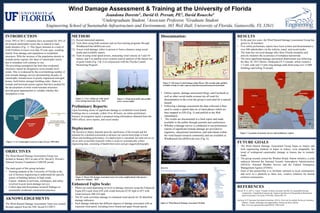
  • 1. Dissemination: • Online reports, damage-assessment blogs, and Facebook as well as other social media avenues are all used for dissemination in the event the group is activated for a natural hazard. • Following a damage assessment the data collected is then used to create a spatial data set of rated photos which are then mapped in GIS (Fig. 5) and publish to the Web immediately • The results are documented in a final report and made available to the public through journals and conferences. • Whether a damage survey is conducted or not preliminary reports of significant tornado damage are provided to engineers, educational institutions, and individuals within the wind hazard research community and are available at Windhazard.DavidOPrevatt.com (Fig. 6). Wind Damage Assessment & Training at the University of Florida Jeandona Doreste1, David O. Prevatt, PE2, David Roueche3 1Undergraduate Student, 2Associate Professor, 3Graduate Student Engineering School of Sustainable Infrastructure and Environment, 365 Weil Hall, University of Florida, Gainesville, FL 32611 OBJECTIVES The Wind Hazard Damage Assessment Group was formed in January 2012 as part of Dr. David O. Prevatt’s National Science Foundation CAREER award. The main goals of this group includes: • Training students at the University of Florida in the use of forensic engineering to understand the specific causes of building failures in high winds • Expose students to activities, techniques, and safety involved in post-storm damage surveys • Collect data and disseminate research findings on sustainable residential construction practices. METHOD (1) Recruit interested students, (2) Train them using both seminars and on-line training programs through Windhazard.DavidOPrevatt.com, (3) Assess wind damage, either in person or from a distance using social media and available reports, (4) Train in using wind speed towers, measuring wind velocity at 5 and 10- meters, and 5-m satellite tower systems used in analysis of the lateral size of gusts winds (Fig. 2 & 3) in conjunction with the Florida Coastal Monitoring Program. Preliminary Reports: Upon becoming aware of significant damage to residential wood famed buildings due to a tornado, within 24 to 48 hours, an online preliminary forensic investigation report is prepared using information obtained from the NWS offices, news reports, and social media. Deployment: The decision to deploy depends upon the significance of the tornado and the potential for a detailed assessment to advance our current knowledge of wind effects and building performance. If a deployment is warranted, the team arrives on site as early as possible (typically within a week) to systematically collect engineering data, consisting of handwritten notes and geo-tagged photographs. Enhanced Fujita Scale: • Photos are rated depending on level of damage intensity using the Enhanced Fujita (EF) scale from EF0 with winds between 65-85 mph to EF5 with winds between 200-234 mph • The EF scale correlates damage to estimated wind speeds for 28 identified damage indicators • Each damage indicator has different degrees of damage associated with an expected wind speed, including lower bound and upper bound speeds. AKNOWLEDGEMENTS The Wind Hazard Damage Assessment Team was created through support from the NSF Award #1150975. Figure 1: Operating PNE device INTRODUCTION From 1993 to 2012, tornadoes have accounted for 36% of all insured catastrophic losses due to natural or man- made disasters (Fig. 1). This figure amounts to a total of $140.9 billion in losses over that 19-year span, resulting mainly from damage and reparations to residential structures. With the increase of the population density in tornado-prone regions, the share of catastrophic losses due to tornadoes will continue to rise. The prevailing assumption has been that residential structures cannot be designed to resist tornado level winds. This is evidenced by the overwhelming number of post-tornado damage surveys documenting decades of catastrophic tornado loses to poorly engineered and aged homes, built before stronger building codes. States in tornado and hurricane-prone regions that have pushed for the development of more wind-resistant structures provide great opportunities to validate whether this assumption is true. RESULTS • In the past two years, the Wind Hazard Damage Assessment Group has grown to 20 members • Five online preliminary reports have been written and disseminated to over 500 stakeholders via the website, email, and social media. • The team has surveyed damage after three Florida tornadoes and actively monitors the occurrence of tornadoes nationwide. • The most significant damage-assessment deployment was following the May 20, 2013 Moore, Oklahoma EF-5 tornado, which created a 1.3 mile wide and 17-mile long damage path destroying over 12,000 buildings and killing 24 people. Figure 1: U.S. Catastrophe Losses by Cause of Loss, 1993-2012 REFERENCES Prevatt, D. O. (2011). Career: Tornado-resilient structural retrofits for sustainable housing communities. Unpublished manuscript, Engineering School of Sustainable Infrastructure and Environment, University of Florida, Gainesville, FL. Hartwig, R. P. Insurance Information Institute, (2013). Overview & outlook for the p/c insurance industry: Trends, challenges and opportunities. Retrieved from website: http://www.iii.org/assets/docs/pdf/SWAF-120613.pdf Figure 6: Wind Hazard Damage Assessment Website Figure 2: Crew setting up wind speed tower during hurricane Irene -2011 Figure 3: Wind speed (left) and satellite tower system (right) Figure 4: Moore OK damage assessment team surveying neighborhood with massive progressive damage - 2013 Figure 5: GIS map of rated damage along Moore, OK tornado path, publicly available at http://esridev.caps.ua.edu/mooretornado/mooretornado.html FUTURE GOALS • The Wind Hazard Damage Assessment Group hopes to inspire and train engineering students in hopes to reduce, even marginally, the trend of widespread catastrophic damage to houses due to tornadic loads. • The group recently joined the Weather Ready Nation initiative, a joint endeavor between the National Oceanic Atmospheric Administration (NOAA), National Weather Service and the Federal Emergency Management Agency (FEMA). • Goal of this partnership is to facilitate outreach to local communities and serve as a platform to share new, creative solutions for hazard resilient communities. Figure 7: Locations of tornado surveys and preliminary reports