
Recommended
More Related Content
Similar to 2022/02 情報基盤システム学(NAIST)の研究室紹介
Similar to 2022/02 情報基盤システム学(NAIST)の研究室紹介 (20)
2022/02 情報基盤システム学(NAIST)の研究室紹介
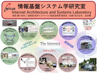
- 1. 情報基盤システム学研究室 Internet Architecture and Systems Laboratory 教授 藤川和利 / 准教授 新井イスマイル/客員准教授 樫原茂 / 助教 垣内正年,油⾕曉 The Internet IoT .53 No.4 1349–1359 (Apr. 2012) 口アイコンの対として,階段から上 コンに相当する.このような入口と する.対となるアイコンが水平視野 ,画面の上部の端に矢印を表示し, けると対となるアイコンが存在する る(図 5) .Google Street View と 真を撮影した緯度・経度は厳密に のつながりを示すアイコンを提示す は階層間をつなぐ施設とその対応に ことができる.詳細情報はパノラマ ウスオーバ前 ウスオーバ後 内につながりがない場合 e the odd end is not visible. 表 1 パノラマ情報の詳細 Table 1 The details of a panoramic information. 名称 型 詳細 panoId text パノラマ写真の識別子 latlng geometory point パノラマ写真撮影地点の緯度・経度 yawdeg float パノラマ写真撮影方位(0∼360,0:北) link panoId text 隣接する panoId 表 2 DB のアイコン情報の詳細 Table 2 The details of a icon information in DB. 名称 型 詳細 id int DB 内の識別子 ontent type int 階層間をつなぐ施設の種類( 「0:上り階段」など) latlng geometory point 階層間をつなぐ施設の緯度・経度 height double アイコンを表示する高さ title text 階層間をつなぐ施設の名称と識別子 comment text 階層間をつなぐ施設の名称 user id int コンテンツ作成者の識別子 created at date コンテンツ作成時刻 ビューを用いて,また周辺の大局的な情報は 2 次元地図を 用いることを想定した提案手法のインタフェースを図 6 に 示す. 地上と地下それぞれのパノラマ写真が持つパノラマ情 報を表 1 に,階層間をつなぐ施設に表示するアイコンが 持つアイコン情報を表 2 に示す.パノラマ写真撮影地点 の座標は緯度・経度で記録されており,実装したパノラマ ビューの球の中心を示す.アイコンにも緯度・経度と高さ による座標が与えられているため,パノラマ写真撮影地点 との相対的な方位と距離,そして仰角を求めることで描画 できる.このときのアイコンの高さについては,パノラマ 写真の大まかな水平線に合わせて 0 としている.1 つの階 層間をつなぐ施設に対し,地上と地下それぞれのパノラマ 写真に合わせて 2 つのアイコンの座標を計算し,描画して いる.地上のアイコンは地上のパノラマ写真上のみに,そ して地下のアイコンは地下のパノラマ写真上のみに表示す ることで,モード切替えにともない球の中心となる緯度・ 経度がずれても,正しい位置にアイコンを描画できる. 図 6 提案手法のインタフェース Fig. 6 The proposed interface. Smart phone Other vehicle Smart home Security Operation Center/ Insurance company/… Internet Edge server Wi-Fi/ Bluetooth 4G/5G, LTE Domain Controller/IDS IDS ECU ECU ECU ECU ECU In-vehicle Infotainment Central Gateway Router ECU ECU ECU ECU CAN/CAN FD Ethernet CAN/CAN FD OBD-II port Switch Switch Switch ECU ECU ECU ECU Domain Controller Domain Controller/IDS In-vehicle network Ethernet Hardware Trojan, Malware Connected equipments Sensing data Sensors Actuators DoS attack (B206 LAN LAN Wireless LAN H27 (2015 9 1 ) Software Defin IP GPU Delay Tolerant Network MANET/VANET Sensor Network
- 3. 総合情報基盤センター ・ 学内インフラ ! 学⽣が使うネットワークや計 算機リソースを管理 ・ 世界最速レベル ! 25.4PB (テープドライブ含) ! TFLOPSクラスの計算サーバ群 ! 100Gbpsの基幹ネットワーク ! 1⼈1台のワークステーション (ラップトップ)
- 6. バスBigdata ・6年間で30台弱のバスから約1TBのデータ収集 5 • GPS (Lat., Lng., Alt., Azimuth) • Vehicle speed • Engine speed • Travel distance • Engine pulse • Direction • Atmospheric pressure • Temperature • Humidity • Amount of fuel • Near future • Accelerometer • Gyroscope • CAN data
- 7. バス企業の課題 ・労働者不⾜&煩雑な機器操作 Too many operations of drivers 6 1運行管理者で20人以上の運転者を管理
- 8. 運⾏状態推定 ・現状は運転者が運⾏中に11種類の運⾏状態を ⼿⼊⼒・・・ ・⾃動化で解決したい 7 👆 Maintenance inspection work before dispatching Washing car washing and cleaning the bus Dispatching moving towards the first bus stop Waiting waiting at the first bus stop In service bus is in service Taking a break taking less than 4 hours break Out of service moving to the garage after the bus finishes service Refueling refueling at a gas station At garage parking at the garage
- 9. センシングで解決 ・⼿⼊⼒より精度向上 8 👆 81% 93% 手入力 12特徴量 11状態 ランダムフォレスト 分類器 Takuya Yonezawa, Ismail Arai, Toyokazu Akiyama, Kazutoshi Fujikawa, “Random Forest Based Bus Operation States Classification Using Vehicle Sensor Data,” 2018 International Workshop on Pervasive Flow of Things (PerFot 2018), IEEE PerCom 2018, pp.819--824, Greece, March, 2018.
- 12. センサフュージョンによる 乗降者数判定 11 Hayato Nakashima, Ismail AraiKazutoshi Fujikawa, “Passenger Counter Based on Random Forest Regressor Using Drive Recorder and Sensors in Buses,” 2019 International Workshop on Pervasive Flow of Things (PerFot 2019), IEEE PerCom 2019, pp. 561—566, Kyoto, March, 2019. 他 乗車: 89.6% 降車: 82.6% 乗車: 96.7% 降車: 87.9% 乗車: 98.6% 降車: 98.6% 改善 肉薄 画像処理のみ (YOLOv3 + Deep SORT) 提案手法 専用品
- 13. 危険運転分析 ・6連勤で急ブレーキ・スピード違反が増加 12 Figure 1. Architecture for data acquisition 1st day 6th day Figure 2. Comparison of same driver’s driving history by continuous work F ing to ideal tion f opera delay result the bo be use Oper In above neous tion o senso ified. and da
- 15. 応⽤先は様々 Block fence detection Unwanted fragility against earth quake 14 Treepedia@Senseable City Lab, MIT ブロック塀の検出も可能?
- 16. 環境はますます充実 ・ 初期 (-2014) ! GPS ! ⾞速、エンジン回転数、燃料残量 ・ 追加 (2014-) ! 温度・湿度・気圧 ! ドア開閉、ワイパー ! ドラレコ6ch (70GB/⽇・台) ・ 未アップロード or 追加検討中 (2018-) ! 加速度、ジャイロ、RTK GNSS ! CO2 ! CAN data ! バス停のサイネージ、カメラ ・ 街中のセンシングに必要なもの (2019-) ! 熱画像、⼤気汚染、⼈流… 15 みなと観光バス デジタル標柱
- 19. バスは巡回センシング基盤 A platform for fixed point observation! (Ex. Atmospheric pressure sensed from the buses on the move in an area of 50m square) 18 Temporal Coverage Frequency Spatial Coverage Density Trash truck Bus 1010 1011 1012 1013 1014 1015 8:00 8:10 8:20 8:30 8:40 8:50 9:00 Atmospheric pressure [hPa] Times of day 5分間の定点観測基盤に! 既存研究(ゴミ収集車)との比較
- 20. その他のユビキタスコンピューティングに 関する研究 ・公共交通ビックデータ解析 ! ConvLSTMを⽤いたバス到着時間予測⼿法 ! 統計的解析による路線バスの混雑度予測⼿法 ・屋内測位 ! 地磁気の時系列データを⽤いた屋内測位⼿法 ! 地磁気/LPWAを⽤いた3次元屋内測位⼿法 様々なユビキタスに関する研究を行ってます!
- 21. カーセキュリティ ・⾞載ネットワークに対する攻撃により⾞両の制 御を乗っ取られた報告が多数されている ・Jeep hack (2015) ! 通信機能の脆弱性を利⽤し、 無改造のJeepを遠隔操作 →140万台がリコール 本研究室でもカーセキュリティ について検証中
- 22. カーセキュリティの研究例 ・Deep Learning (LSTM)を⽤いた侵⼊検知⼿法 ! 各送信先IDに対してNetworkを構築 92.5%(CAN ID 305) ROC Area . . . Cell1 Cell2 cell3 LSTM Cell CAN Bus Actual packet TH predicted packet MSE calc. >TH . . . <TH Anomaly Benign
- 23. カーセキュリティの研究例 ・Entropyに基づくDoS攻撃検知機構[1]を回避する 攻撃⼿法とその防御⼿法 2.5 3 3.5 4 4.5 0 50 100 150 200 250 300 350 400 Entropy Window Random DoS attack [0, 55] Normal CAN messages 2.5 3 3.5 4 4.5 0 50 100 150 200 250 300 350 400 Entropy Window Random DoS attack [0, 2047] Normal CAN messages 100.0% 68.3% 攻撃検知機構の 検出精度 通常のDoS攻撃 [1] Wu, W., Huang, Y., Kurachi, R., Zeng, G., Xie, G., Li, R. and Li, K.: Sliding windows Optimized Information Entropy Analysis Method for Intrusion Detection on In-Vehicle Networks, IEEE Access, Vol 6, pp.45233-45245, (2018). ーDoS attack ーNormal ーDoS attack ーNormal Entropyを操作したDoS攻撃
- 25. カーセキュリティの研究例 ・⾞載ネットワークの物理層の特徴を⽤いたIDS ! ⾼い粒度で時間計測可能なTDCによる特徴量を取得 - 従来⼿法: 81.43% - 提案⼿法: 99.67% IDSのプロトタイプと実験の様子 99.67% ECUの 識別精度
- 26. その他のセキュリティに関する研究 ・Web/Browser Security ! Client-Side XSS (DOM-Based XSS) に対する防御⼿法 ・Network Security ! Entropyを⽤いたRemote Access Trojanの検出⼿法 ! 機械学習/IPフロー情報を⽤いたマルウェア通信検出⼿法 ・IoT Security ! 産業⽤IoT機器に対するDoS攻撃の検出⼿法 様々なセキュリティに関する研究を行ってます!
- 29. ⾼精細映像の⾮圧縮IP伝送
- 30. 他にも多数の研究を⾏ってます! The Internet IoT .53 No.4 1349–1359 (Apr. 2012) 口アイコンの対として,階段から上 コンに相当する.このような入口と する.対となるアイコンが水平視野 ,画面の上部の端に矢印を表示し, けると対となるアイコンが存在する る(図 5) .Google Street View と 真を撮影した緯度・経度は厳密に のつながりを示すアイコンを提示す は階層間をつなぐ施設とその対応に ことができる.詳細情報はパノラマ ウスオーバ前 ウスオーバ後 内につながりがない場合 e the odd end is not visible. 表 1 パノラマ情報の詳細 Table 1 The details of a panoramic information. 名称 型 詳細 panoId text パノラマ写真の識別子 latlng geometory point パノラマ写真撮影地点の緯度・経度 yawdeg float パノラマ写真撮影方位(0∼360,0:北) link panoId text 隣接する panoId 表 2 DB のアイコン情報の詳細 Table 2 The details of a icon information in DB. 名称 型 詳細 id int DB 内の識別子 ontent type int 階層間をつなぐ施設の種類( 「0:上り階段」など) latlng geometory point 階層間をつなぐ施設の緯度・経度 height double アイコンを表示する高さ title text 階層間をつなぐ施設の名称と識別子 comment text 階層間をつなぐ施設の名称 user id int コンテンツ作成者の識別子 created at date コンテンツ作成時刻 ビューを用いて,また周辺の大局的な情報は 2 次元地図を 用いることを想定した提案手法のインタフェースを図 6 に 示す. 地上と地下それぞれのパノラマ写真が持つパノラマ情 報を表 1 に,階層間をつなぐ施設に表示するアイコンが 持つアイコン情報を表 2 に示す.パノラマ写真撮影地点 の座標は緯度・経度で記録されており,実装したパノラマ ビューの球の中心を示す.アイコンにも緯度・経度と高さ による座標が与えられているため,パノラマ写真撮影地点 との相対的な方位と距離,そして仰角を求めることで描画 できる.このときのアイコンの高さについては,パノラマ 写真の大まかな水平線に合わせて 0 としている.1 つの階 層間をつなぐ施設に対し,地上と地下それぞれのパノラマ 写真に合わせて 2 つのアイコンの座標を計算し,描画して いる.地上のアイコンは地上のパノラマ写真上のみに,そ して地下のアイコンは地下のパノラマ写真上のみに表示す ることで,モード切替えにともない球の中心となる緯度・ 経度がずれても,正しい位置にアイコンを描画できる. 図 6 提案手法のインタフェース Fig. 6 The proposed interface. ociety of Japan 1352 Smart phone Other vehicle Smart home Security Operation Center/ Insurance company/… Internet Edge server Wi-Fi/ Bluetooth 4G/5G, LTE Domain Controller/IDS IDS ECU ECU ECU ECU ECU In-vehicle Infotainment Central Gateway Router ECU ECU ECU ECU CAN/CAN FD Ethernet CAN/CAN FD OBD-II port Switch Switch Switch ECU ECU ECU ECU Domain Controller Domain Controller/IDS In-vehicle network Ethernet Hardware Trojan, Malware Connected equipments Sensing data Sensors Actuators DoS attack (B206 LAN LAN Wireless LAN H27 (2015 9 1 ) Software Defin IP GPU Delay Tolerant Network MANET/VANET Sensor Network
- 31. 私達のターゲット インターネットに関する幅広〜い分野 ・幅広い分野から学⽣さんたちを受け⼊れています ! 出⾝分野・専攻 - ⼯学、理学を問わず、経済学、哲学、宗教学、⼈間科学な ど ! ものづくりが好きな⼈ - プログラミング、電⼦⼯作(デジタルオシロもあります)、 ガジェット作成など ! ハッカーな⼈ - セキュリティキャンプ/SecHack365、 CTF、ハッカソンイベントなど ! 実際の業務に触れてみたい⼈ - 総合情報基盤センター、バス会社、海上⾃衛隊など
- 32. 環境構築輪講 ・⾃分が使うネットワークを⾃分でつくろう! ! UTPケーブル(LANケーブル)の端⼦⾃作 ! プロ向けネットワーク機器の設定 ! UNIX系OSの正しい運⽤ センター所属の実運用の プロフェッショナルが指導!
- 33. ミニプロジェクト ・実装⼒をつける ・「もの作り」の楽しさを味わおう ! OSカーネルトレースを⽤いた 侵⼊検知システム ! 地磁気を使った屋内測位システム ! IoT向けプロトコル(MQTT)の実装 ! 公共交通機関のセンサデータ解析 ! マルウェア解析 ! LOWSAN(後述)購買システム開発 ! などなど,アイデア次第
- 34. その他の学びの機会 ・有志により様々な勉強会の開催 ! CTF勉強会 - SECCON Online CTF等有志で参加してます ・⼈材育成プログラム ! セキュリティ:SecCap ! 起業家育成:GEIOT
- 36. 共同研究先 ・inet-labは外部の様々な機関と研究コミュニティを 多数持っています ! 海外 - インドネシア:Universitas Jenderal Soedirman - USA:James Madison University ! 国内 - WIDEプロジェクト、サイバー関⻄プロジェクト - NICT(独⽴⾏政法⼈ 情報通信研究機構) - NTT未来ねっと研究所 - 朝⽇放送(ABC)、スカパーJSAT、みなと観光バス - 東京⼤学、⼤阪⼤学、慶應義塾⼤学、京都産業⼤学、⽴命 館⼤学、神奈川⼯科⼤学