Apidays New York 2024 - Accelerating FinTech Innovation by Vasa Krishnan, Fin...
Ais guide
1. AUTOMATIC IDENTIFICATION SYSTEM
USCG AIS Encoding Guide
v.25
This Guide is intended to assist in the
proper encoding of an Automatic
Identification System (AIS) used in
U.S. navigable waters
AIS is a valuable navigation safety radio communication tool.
However, its effectiveness is undermined by the broadcast of
inaccurate, improper or outdated data. Users are reminded
that U.S. regulations (33 CFR 164.46) require that it be
maintained in effective operating condition, which includes
accurate input and upkeep of all AIS data parameters.
Continual failure to do so may prompt civil penalty action. To
avoid penalties, always ensure your AIS is up-to-date and
encoded according to this Guide.
Dynamic Data…must be encoded via external
systems that are type-certified, properly
installed, and operational1
• Electronic Positioning Fixing System (EPFS), Transmitted
Heading (THD), and Rate of Turn (ROT) sensors, per 33
CFR 164.46(c), must be interfaced to the AIS on the
following vessels on international voyage passenger ships
of 150 gross tonnage (GT) or more; cargo ships of 300 GT
or more, or of 50,000 GT or more, respectively. An
external EPFS is not required on vessels that solely
operate domestically.
• Pilot Plug, on vessels required to embark pilots, must be
readily available and easily accessible from the primary
conning position of the vessel and permanently affixed
(not an extension cord) and adjacent (within 3 feet) to a
120-volt 50/60 Hz AC power receptacle (NEMA 5-15).
Safety-Related Text Messaging…must be short,
concise, and used only to exchange pertinent
navigation safety-related information
• AIS safety-related text messages (SRM) must be in
English and used solely to exchange navigation safety
information. Keep SRM concise and as short as possible
(less than 90 characters). The use of abbreviations is
acceptable and highly encouraged; see the Notice to
Mariners, USCG Local Notice to Mariners, Light List, and
U.S. Nautical Chart No. 1 for a listing of common
abbreviations.
• Although not prohibited, AIS text messaging should not
be relied upon as the primary means for distress
(MAYDAY) or urgent (PAN PAN) communications.
2
• Use of AIS mobile devices ashore is prohibited, except for
FCC licensed Maritime Support Stations; which may test
equipment up to an hour per day.
Static Data…should be encoded at installation and reflect the
vessel’s official radio license or documentation
• Maritime Mobile Service Identity (MMSI)
3
must reflect the MMSI
assigned to the vessel by the FCC or one of its agents.
• Vessel Names that exceed the AIS’s 20 character limit should be shortened
(not truncated) to 15 character-spaces, followed by an underscore {_},
thence the last 4 characters-spaces of the vessel name, e.g. GRAND JOLLY
ROGER OF THE SEA to GRAND JOLLY OF _ SEA, THE GRAND JOLLY ROGER to THE
GRAND JOLLY_OGER. Names should not include vessel type precursors, e.g.
F/V, M/V, MV, OSV, P/V, REC, S/V, T/B; except public vessels, e.g. CG, CBP, USN,
LAPD, NYFD, WSF. Undocumented vessels should reflect the vessel’s state
registration number−vice name̶̶−preceded by ‘US#’, e.g. US#AZ1234YZ.
Associated (daughter) craft or tenders, should reflect the parent vessel’s
name, followed by a numerical sign {#}, and a sequential number that
distinguishes it from the vessel’s other crafts. For example, the third tender
of the JOLLY ROGER should be encoded as JOLLY ROGER#3. Additionally, its AIS
call-sign parameter should reflect the last 6-digits of JOLLY ROGER’s MMSI
preceded by the letter ‘A’, e.g. A123456.
• Call-sign must reflect the call-sign assigned to the vessel by
the FCC; absent an assignment, leave blank.
• IMO Number
4
must reflect the assigned 7-digit IMO number.
Use leading zeroes (not trailing zeroes) to fill the parameter,
e.g. 0001234567. U.S. vessels without an IMO assignment
should (if your AIS is 10-digit capable) input their U.S. official
number preceded by ‘10000’, e.g. 1001234567, 1000123456.
• Type of positioning source must reflect the
actual positioning system in use; i.e. interfaced
to the AIS or the internal AIS EPFS.
• Type of vessel (and cargo) should reflect the
appropriate Ship Type listed in the Table; but,
not its cargo type.
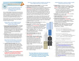
• Antenna Position | Dimensions (ABCD values)
must be encoded in meters, not feet, and reflect
the overall dimensions of the vessel, ABDC
values expressed as the distance fore (A), aft
(B), to port (C), and to starboard (D) to the
positioning-system antenna used by AIS; the
intersection of the two white lines in the
diagram. Improper calibration or encoding could
navigation safety.
U.S. Ship Type 57,’Spare–for assignments to local
vessels’ (See Table) is to be used by vessels towing
ahead or alongside, who’s dimensions reflect the
overall rectangular area of the vessel and its
tow—as shown in the Figure.
Record your ABCD values and know your password—
you will need them to reprogram your static data.
Note, Class B devices in the U.S. can only be encoded
by the vendor or manufacturer’s agent.
Voyage Related Data…should be encoded as needed
and kept accurate and up to date
• Navigation Status must always be up-to-date, i.e. at anchor,
underway, engaged in fishing, etc. Vessels engaged in towing,
if capable, should use Navigation Status ‘11’ when towing
astern or ‘12’ when pushing ahead or alongside5
Remember to change update your status when at anchor
or moored, which reduces AIS reporting rates to every 3
minutes; thus mitigates network congestion and
improves overall AIS efficiency and range.
• Static Draft must be encoded in meters, not feet, and reflect
the vessel’s actual or maximum draft.
• People on Board (POB), although some legacy AIS devices
allow for POB reporting it is not required.
• Estimated Time of Arrival (ETA) must be encoded in
Universal Time Coordinated (UTC), not local time; and, reflect
the ETA to your destination or voyage departure time, if
moored or anchored. Not applicable to vessels on unknown
or variable schedules (e.g. workboats).
• Destination6
and your origination must be encoded using 5-
character UN location codes (UN/LOCODE) for (per IMO
SN/Circ.244) or 4-character U.S. Geographic Unique ID
(US/GUID) codes
7
, as follows:
Origination>Destination using UN/LOCODE only
USNYC>NLRTM …one-way voyage New York City to Rotterdam
USCIR>USMSY>USCIR …a roundtrip between Cairo, IL and New Orleans, LA
USHOU<>USHOU …operating solely within a well defined area, e.g. fleeting
area, vessel traffic service area, etc.
Origination>Destination using US/GUIDonly
US^0Y0P><0Q6L …a scheduled route, e.g. Staten Island Ferry
US^OX6M>OWYY>OX6M …a roundtrip between Cairo, IL and New Orleans, LA
US^0NVR<< …anchored, moored, or on station (e.g. MODU, FPSO)
Origination>Destination using UN/LOCODE and US/GUID
CNSHA>US^0VCY …for Shanghai to San Francisco Pier 35
Note, the difference in symbology { ^ | > | >< | << | <> }
8
1. Per either IMO SN/Circ. 227 & 224 or NMEA 0400:3-10 Installation
Guidelines.
2. See 47 CFR 80.1109–Distress, urgency, and safety communications.
3. See http://wireless.fcc.gov/services/index.htm {Ship Radio Stations}.
4. Obtained at www.imonumbers.lrfairplay.com/datause.aspx.
5. Older AIS devices will not offer these statuses or may show them as
‘Reserved for Future’ use. Although not required, we exhort all AIS users
to seek AIS firmware upgrades to avail themselves of these advantageous
statuses.
6. Any port or offshore place in which a vessel is bound to embark or
disembark vessel passengers, crew or cargo (not barge movements); or
anchor or maintain station for extended period of time (e.g. anchorage,
Outer Continental Shelf (OCS) activity).
7. IMO SN/Circ.244, country (ISO 3166), United Nations Location
(UN/LOCODE), or U.S. Geographic Unique Identifiers (US/GUIDS) codes for
ports, places, berths, routes, and waterways, can befound (or torequestthe
later) at: www.navcen.uscg.gov/locode.
8. If your AIS lacks angle brackets {>} characters, substitute with parenthesis:
{ ) | )( | () | (| (( }
2. The AIS ‘Type of Ship’ parameter is listed as a 2-digit numeric code and/or labeled as shown in the columns below.
Blue italic text is amplifying text not found in the original source (ITU-R M.1371-5) or your AIS. The terms used are as defined in IMO SOLAS, 46 U.S.C. 2101 or 33 CFR 140.10.
1
st
digit 2
nd
digit [3x] others “engaged in” [5x] special craft
0 – Not available 0 – All ships of this type
30 – Fishing should include fish processors and fish
tenders*
50 – Pilot vessel
1 – Reserved for future use
1 – Carrying DG, HS or MP , IMO hazard or
pollutant category X DO NOT USE
31 – Towing ahead or alongside, but, not astern*
51 – Search and rescue vessels, i.e. USCG boats, USCG Auxiliary boats,
assistance towers, first-responders, standby vessels
2 – WIG (Wing-In-Ground) craft
2 – Carrying DG, HS, or MP, IMO hazard or
pollutant category Y DO NOT USE
32 – Towing astern, regardless whether the and
length of the tow exceeds 200 m or breadth
exceeds 25 m*
52 – Tugs, light boats, fleet boats, or similar workboats
3 – Other vessels engaged in actions
listed in column [3x]
3 – Carrying DG, HS, or MP, IMO hazard or
pollutant category Z DO NOT USE
33 – Engaged in dredging or underwater operations,
or other equipment operations that may obstruct
navigation (such as buoy tending, exploration, ice
breaking, production, salvaging, sampling,
surveying, or other similar activities, but, not
diving, fishing, towing or military operations)*
53 – Port tenders, yacht tenders, dive tenders, attending and off-shore
supply vessels, or similar support craft; but, not fish tenders
4 – HSC (hi-speed craft) or passenger
ferries
4 – Carrying DG, HS, or MP, IMO hazard or
pollutant category OS DO NOT USE
34 – Engaged in diving operations or other types of
operations with persons in the water*
54 – Vessels with anti-pollution facilities or equipment
5 – Special craft per column [5x] 5 – Reserved for future use
35 – Engaged in military operations or other types of
restricted operations*
55 – Law enforcement vessels, i.e. U.S. Customs and Border Protection
vessels, Department of Natural Resources Conservation boats,
marine police boats , etc.
6 – Passenger ships other than HSC
and passenger ferries; not
including tenders or off-shore
supply vessels [see 53]
6 – Reserved for future use 36 – Sailing vessels* 56 – Spare–for assignments to local vessels DO NOT USE
7 –Cargo (freight) ships or integrated
tug barge (ITB) vessels
7 – Reserved for future use 37 – Pleasure craft
57 – Spare–for assignments to local vessels, i.e. articulated tug-barges,
pushboats, long haulers, whose dimensions (See Fig.1, ABCD values)
represent the overall rectangular area of the vessel including its tow*
Do not use when ABCD values DO NOT include the tow
8 – Tankers or integrated tug tank
barge vessels
8 – Reserved for future use 38 – Reserved for future use
58 – Medical transports (as defined in the 1949 Geneva Convention and
Additional Protocols) or similar public safety vessels
9 – Other types of ship 9 – No additional information 39 – Reserved for future use 59 – Ships according to RR Resolution No. 18 (Mob-83)
* Also update your Navigation Status accordingly, i.e. 3 = restricted maneuverability; 7 = engaged in fishing; 8 = under sail; 11 = towing astern; 12 = pushing ahead/alongside, etc.
Redistribution with or without USCG indicia is permissible and encouraged. For further information or additional copies visit www.navcen.uscg.gov [AIS FAQ#2] or email cgnav@uscg.mil
![The AIS ‘Type of Ship’ parameter is listed as a 2-digit numeric code and/or labeled as shown in the columns below.
Blue italic text is amplifying text not found in the original source (ITU-R M.1371-5) or your AIS. The terms used are as defined in IMO SOLAS, 46 U.S.C. 2101 or 33 CFR 140.10.
1
st
digit 2
nd
digit [3x] others “engaged in” [5x] special craft
0 – Not available 0 – All ships of this type
30 – Fishing should include fish processors and fish
tenders*
50 – Pilot vessel
1 – Reserved for future use
1 – Carrying DG, HS or MP , IMO hazard or
pollutant category X DO NOT USE
31 – Towing ahead or alongside, but, not astern*
51 – Search and rescue vessels, i.e. USCG boats, USCG Auxiliary boats,
assistance towers, first-responders, standby vessels
2 – WIG (Wing-In-Ground) craft
2 – Carrying DG, HS, or MP, IMO hazard or
pollutant category Y DO NOT USE
32 – Towing astern, regardless whether the and
length of the tow exceeds 200 m or breadth
exceeds 25 m*
52 – Tugs, light boats, fleet boats, or similar workboats
3 – Other vessels engaged in actions
listed in column [3x]
3 – Carrying DG, HS, or MP, IMO hazard or
pollutant category Z DO NOT USE
33 – Engaged in dredging or underwater operations,
or other equipment operations that may obstruct
navigation (such as buoy tending, exploration, ice
breaking, production, salvaging, sampling,
surveying, or other similar activities, but, not
diving, fishing, towing or military operations)*
53 – Port tenders, yacht tenders, dive tenders, attending and off-shore
supply vessels, or similar support craft; but, not fish tenders
4 – HSC (hi-speed craft) or passenger
ferries
4 – Carrying DG, HS, or MP, IMO hazard or
pollutant category OS DO NOT USE
34 – Engaged in diving operations or other types of
operations with persons in the water*
54 – Vessels with anti-pollution facilities or equipment
5 – Special craft per column [5x] 5 – Reserved for future use
35 – Engaged in military operations or other types of
restricted operations*
55 – Law enforcement vessels, i.e. U.S. Customs and Border Protection
vessels, Department of Natural Resources Conservation boats,
marine police boats , etc.
6 – Passenger ships other than HSC
and passenger ferries; not
including tenders or off-shore
supply vessels [see 53]
6 – Reserved for future use 36 – Sailing vessels* 56 – Spare–for assignments to local vessels DO NOT USE
7 –Cargo (freight) ships or integrated
tug barge (ITB) vessels
7 – Reserved for future use 37 – Pleasure craft
57 – Spare–for assignments to local vessels, i.e. articulated tug-barges,
pushboats, long haulers, whose dimensions (See Fig.1, ABCD values)
represent the overall rectangular area of the vessel including its tow*
Do not use when ABCD values DO NOT include the tow
8 – Tankers or integrated tug tank
barge vessels
8 – Reserved for future use 38 – Reserved for future use
58 – Medical transports (as defined in the 1949 Geneva Convention and
Additional Protocols) or similar public safety vessels
9 – Other types of ship 9 – No additional information 39 – Reserved for future use 59 – Ships according to RR Resolution No. 18 (Mob-83)
* Also update your Navigation Status accordingly, i.e. 3 = restricted maneuverability; 7 = engaged in fishing; 8 = under sail; 11 = towing astern; 12 = pushing ahead/alongside, etc.
Redistribution with or without USCG indicia is permissible and encouraged. For further information or additional copies visit www.navcen.uscg.gov [AIS FAQ#2] or email cgnav@uscg.mil](data:image/gif;base64,R0lGODlhAQABAIAAAAAAAP///yH5BAEAAAAALAAAAAABAAEAAAIBRAA7)