30 UAE Weather uae-tc-formation-31-may ws
•
0 gefällt mir•472 views

UAE Weather TS Formation 31 May 2010

Empfohlen
Weitere ähnliche Inhalte
Kürzlich hochgeladen
Kürzlich hochgeladen (20)
Empfohlen
Empfohlen (20)
30 UAE Weather uae-tc-formation-31-may ws
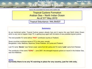
- 1. Issued 31st May 2010 Points2Deliver UAE Weather Update Source: Info. accumulated from several online weather sites www.dubai-travel-uae-guide.com Tropical Cyclone Formation Arabian Sea – North Indian Ocean As of 31st May 2010 Tropical Disturbance: 94A.INVEST Summary: As we mentioned earlier, Tropical Cyclone season already here and it seems this year North Indian Ocean which is very rare to happen major TC, is getting busy again with formation of new possible tropical cyclone. The next possible TC name will be “PHET” contributor country is Thailand. Seven countries contribute names of TC in this area, namely: Bangladesh, India, Maldives, Myanmar, Oman Pakistan, Sri Lanka and Thailand. Last TC name “Bandu” near Yemen coast came from Sri Lanka and TC name “Laila” came from Pakistan. The contributor of the name “GONU” – June 2007, the strongest tropical cyclone on record in the Arabian Sea, was from Maldives. NOTE: Currently there is no any TC warning in place for any country, just for info only.
- 2. Points2Deliver Current Tropical Cyclones - Indian Ocean www.dubai-travel-uae-guide.com Somali Image Source: Hurricanzone.net
- 3. Points2Deliver Current Tropical Cyclones – Norhth Indian Ocean www.dubai-travel-uae-guide.com Tropical Disturbance: 94A.INVEST 31st May 2010: REMARKS: THE AREA OF CONVECTION PREVIOUSLY LOCATED NEAR 14.4N 64.2E, IS NOW LOCATED NEAR 14.9N 64.1E, APPROXIMATELY 545 NM WEST- SOUTHWEST OF MUMBAI, INDIA. ANIMATED MULTISPECTRAL AND INFRARED SATELLITE IMAGERY SHOW CONTINUED CONSOLIDATION OF THE LOW LEVEL CIRCULATION CENTER (LLCC) WITH INCREASED DEEP CONVECTION BUILDING IN THE VICINITY OF THE LLCC. UPPER LEVEL ANALYSIS INDICATES AN ANTI- CYCLONE LOCATED OVER THE NORTHERN ARABIAN SEA IS PROVIDING FAVORABLE EQUATORWARD OUTFLOW AND CREATING A MODERATE VERTICAL WIND SHEAR ENVI- RONMENT FOR THE LLCC. SURFACE CONDITIONS ARE FAVORABLE WITH SEA SUR- FACE TEMPERATURES AROUND 31 CELSIUS BASED ON RECENT BUOY AND SHIP OBSERVATIONS. MAXIMUM SUSTAINED SURFACE WINDS ARE ESTIMATED AT 25 TO 30 KNOTS. THIS IS SUPPORTED BY A 310507Z ASCAT SCATTEROMETRY IMAGE AND A SHIP OBSERVATION JUST TO THE WEST OF THE LLCC. MINIMUM SEA LEVEL PRESSURE IS ESTIMATED TO BE NEAR 1005 MB. BASED ON BUILDING DEEP CONVECTION AND FAVORABLE SURFACE CONDITIONS, THE POTENTIAL FOR THE DEVELOPMENT OF A SIGNIFICANT TROPICAL CYCLONE WITHIN THE NEXT 24 HOURS IS UPGRADED TO GOOD. . 3 Image Source: Tropicalstormrisk
- 4. Points2Deliver Current Tropical Cyclones – Norhth Indian Ocean PAKISTAN UAE SAUDI ARABIA OMAN INDIA 4
- 5. Points2Deliver Path of Tropical Cyclone “GONU” - 2007 END 7th June 2007 START 30th May,2007 Saffir-Simpson Hurricane Scale Photo: Hassan Al Jabri THANK YOU Hassan Al Jabry Excellence in Motion points2deliver at hotmail.com Note: Weather predictions are made possible using the best technology available today, but still un-expected “freak weather” sometimes may occur which happen very rare. So be ready and do not blame the weather man. www.dubai-travel-uae-guide.com