Maui - Beach Erosion - Politics and Conflicts of Interest
•
1 gefällt mir•122 views

“As such people achieve influence within the organization, whenever there is a conflict between their own interest and the interest of the organization, their interests will win out.” ~ Robert Shea
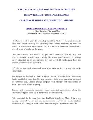
![BEACH MANAGEMENT PLAN FOR MAUI
_______________________
December 1997, accessed December 21, 2017
<https://dlnr.hawaii.gov/occl/fles/2013/08/BeachManagementPlanMaui.pdf>
EROSION HOTSPOTS
East End of Paia Bay
EROSION WATCH SPOTS
MATOKUJI BAY
LOST BEACHES
Portions of Kuau Bay
Portions of Tavares Bay
_______________________
2017
UNIVERSITY OF HAWAII AT MĀNOA
SCHOOL OF OCEAN AND EARTH SCIENCE AND TECHNOLOGY (SOEST)
PAIA MANTOKUJI
Mantokuji Bay, (transects 120 – 131), has experienced moderate to high
erosion over time with an average AEHR of -1.7 ft/yr.
Mantokuji Bay with limited sediment supply has experienced the largest
decrease in average beach width between 1960 and 2002 of 28%.
Source: The Hawaii Shoreline Study – Maui / Baldwin Park. Hawaii Coastal Erosion
Website. Accessed December 21, 2017 http://www.soest.hawaii.edu/coasts/erosion/maui/
[CLICK ON IMAGE TO ENLARGE]
_______________________](data:image/gif;base64,R0lGODlhAQABAIAAAAAAAP///yH5BAEAAAAALAAAAAABAAEAAAIBRAA7)
Empfohlen
Weitere ähnliche Inhalte
Was ist angesagt?
Was ist angesagt? (20)
Ähnlich wie Maui - Beach Erosion - Politics and Conflicts of Interest
Ähnlich wie Maui - Beach Erosion - Politics and Conflicts of Interest (20)
Mehr von Clifton M. Hasegawa & Associates, LLC
Mehr von Clifton M. Hasegawa & Associates, LLC (20)
Kürzlich hochgeladen
Kürzlich hochgeladen (20)
Maui - Beach Erosion - Politics and Conflicts of Interest
- 1. MAUI COUNTY – COASTAL ZONE MANAGEMENT PROGRAM THE ENVIRONMENT - POLITICAL CHALLENGES COMPETING PRIORITIES AND CONFLICTING INTERESTS EROSION DEVOURING MISSION PROPERTY By Chris Sugidono. The Maui News December 20, 2017, accessed December 21, 2017 Members of the 111-year-old Mantokuji Soto Zen Mission of Paia are hoping to save their temple building and cemetery from rapidly increasing erosion that has swept out into the shore break close to a hundred gravestones and claimed several acres of land over the years. “The shoreline has been a threat, but just in the last three years the ocean has been really bad,” temple member Cathy Murayama said Tuesday. “It’s always slowly creeping up on us, but now we can see it 20 yards away from the kitchen, and maybe not even that. “It’s like at our back door, and more than ever we feel the urgency to do something.” The temple established in 1906 is located across from the Paia Community Center and holds more than 600 grave markers in its cemetery along the coast of Mantokuji Bay. Climate change coupled with stronger surf has claimed at least 3 to 4 acres of the property. Temple and community members have recovered gravestones along the shoreline and piled them up in the middle of the cemetery. Paia Mantokuji is the only Soto Zen Buddhist temple on Maui. Soto is the leading school of the sect and emphasizes meditation with no objects, anchors or content, according to “Soto Zen in Medieval Japan” by William Bodiford.
- 2. BEACH MANAGEMENT PLAN FOR MAUI _______________________ December 1997, accessed December 21, 2017 <https://dlnr.hawaii.gov/occl/fles/2013/08/BeachManagementPlanMaui.pdf> EROSION HOTSPOTS East End of Paia Bay EROSION WATCH SPOTS MATOKUJI BAY LOST BEACHES Portions of Kuau Bay Portions of Tavares Bay _______________________ 2017 UNIVERSITY OF HAWAII AT MĀNOA SCHOOL OF OCEAN AND EARTH SCIENCE AND TECHNOLOGY (SOEST) PAIA MANTOKUJI Mantokuji Bay, (transects 120 – 131), has experienced moderate to high erosion over time with an average AEHR of -1.7 ft/yr. Mantokuji Bay with limited sediment supply has experienced the largest decrease in average beach width between 1960 and 2002 of 28%. Source: The Hawaii Shoreline Study – Maui / Baldwin Park. Hawaii Coastal Erosion Website. Accessed December 21, 2017 http://www.soest.hawaii.edu/coasts/erosion/maui/ [CLICK ON IMAGE TO ENLARGE] _______________________
- 3. COMPARE WITH BEACH MANAGEMENT PLAN FOR MAUI Second Edition, June 2008, accessed December 21, 2017 MAUI COUNTY, DEPARTMENT OF PLANNING COASTAL ZONE MANAGEMENT PROGRAM https://www.mauicounty.gov/DocumentCenter/View/10172 FOCUS AREAS – NORTH KAANAPALI – KAANAPALI _______________________ 2017 UNIVERSITY OF HAWAII AT MĀNOA SCHOOL OF OCEAN AND EARTH SCIENCE AND TECHNOLOGY (SOEST) NORTH KAANAPALI Overall, the area has experienced light erosion since 1912 with an average AEHR of -0.3 ft/yr. KAANAPALI As a whole, the study area has experienced moderate erosion since 1912 with an AEHR of -0.6 ft/yr. Source: The Hawaii Shoreline Study – Maui. Hawaii Coastal Erosion Website. Accessed December 21, 2017 http://www.soest.hawaii.edu/coasts/erosion/maui/ [CLICK ON NORTH KAANAPALI AND KAANAPALI and CLICK ON IMAGE TO ENLARGE] _______________________ COMPETING PRIORITIES – CONFLICTING INTERESTS - MIKE WHITE ➢ Chairman of the Maui County Council ➢ Elected to serve the Makawao-Haiku-Paia residency area ➢ General manager, Kaanapali Beach Hotel 1985 to Present