Couper Land: A Photo Essay July 2015
•Als PPTX, PDF herunterladen•
3 gefällt mir•2,998 views

This is a photo journal from a walk we took on the Couper Property in Littleton, MA on July 18 2015. Updated August 17 with developer's current proposal.

Empfohlen
Empfohlen
Weitere ähnliche Inhalte
Andere mochten auch
Ähnlich wie Couper Land: A Photo Essay July 2015
Ähnlich wie Couper Land: A Photo Essay July 2015 (20)
Mehr von Cammy Bean
Mehr von Cammy Bean (20)
Kürzlich hochgeladen
Kürzlich hochgeladen (20)
Couper Land: A Photo Essay July 2015
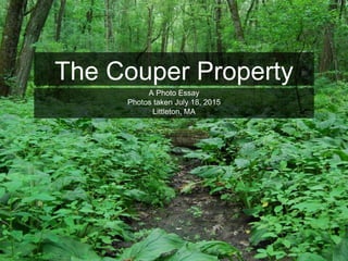
- 1. The Couper Property A Photo Essay Photos taken July 18, 2015 Littleton, MA
- 2. * This map shows the Couper Property outlined in bold yellow. Our photo walk is numbered. 1 2 3 4 5 6 7 8 9 10 11 12 13 14 15 1617 18 19 Image retrieved from http://www.littletonma.org/couperfarm, July 18, 2015. Field names added by author. D. Great Road Field B. Lower Field C. Central Field F. The Wooded Island E. Hilltop Field A. Lower Woods A B C D EF
- 3. Image retrieved from http://www.littletonma.org/couperfarm, July 18, 2015 This map shows the developer’s proposed plan for the Couper Property.
- 4. This stream parallels the SW edge of the Couper property, flowing into the Nashoba Brook via Nonset Brook and Butter Brook. These are the headwaters of the Sudbury-Assabet- Concord (SUASCO) watershed.
- 5. The southernmost corner of the Couper Property, looking north toward the Great Road. 1
- 6. Hidden vistas show a lush and varied forest landscape. 2
- 7. Old stone walls in the forest, heading from Oak Road toward the lower field. 2
- 8. Wet paths along the edge of the Couper Property. 2
- 9. Walking toward the lower field, along the southern edge of the Couper boundary. Much of the year, this muddy area is full of water. 2
- 10. The scarce Indian Pipe grows in the dark understory of dense forests. 2
- 11. Emerging from the forest at the edge of the lower field. A vista is defined as a “pleasing view, especially through a long, narrow opening.” 2
- 12. Verdant grasses and rich soil mark the fields of the Couper Land. 3
- 13. A hidden treasure, you cannot see this field from the Great Road. Nor can you see any signs of manmade structure from within this space and from most of the property. 3
- 14. Were houses to be built on this land, every one of these vistas would disappear. 3
- 15. Swallows swooping over the lower field. A multitude of birds sing from the trees along the edges of the fields. 3
- 16. In the wintertime these fields are criss-crossed with cross country ski, snow shoe, and snowmobile tracks. A lot of recreation happens away from our town’s playing fields. 3
- 17. The unspoiled vista looking back across the lower field from the northeastern corner. 4
- 18. A delightful vista from the lower field into the central field. You can see telephone lines on the Great Road from here, but no cars. 4
- 19. Vista back toward the Great Road. We can hear cars but not see them. 5
- 20. Tractor tracks across the middle of the central field, looking in the direction of Donelan’s. 5
- 21. Wildflowers and lush grass - this is rich soil. 5
- 22. A honeybee enjoying the clover. 5
- 23. The little vistas matter as much as the big ones. 5
- 24. The Great Road is on the other side of this strip of deciduous trees. 5
- 25. Looking back across the central field you see the promise of the lower field peeking through. 6
- 26. Looking toward the Great Road. 6
- 27. New grass growing in the mud of recent tractor treads. 6
- 28. This is rich and fertile soil, bursting with life. 6
- 29. Narrowing our focus, we take time to enjoy the micro vistas. 6
- 30. dRed Sumac growing in the wooded edges. 6
- 31. Looking into the northernmost field on the edge of the Great Road. From here you can see cars passing by every few seconds. 7
- 32. Nearing the Great Road. 7
- 33. And now looking down to the southern edge of the same field. 7
- 34. 77During our entire walk, these were the only vehicles we saw. 7
- 35. 87 At the southern edge of the Great Road field, where the land is fairly high, we saw evidence of perc testing sites. 8
- 36. A perc test hole is dug to test site drainage. 8
- 37. Perc tests assess the rate at which water soaks into the soil. Littleton has recently lowered its perc test standards. 8
- 38. Another perc testing site along the lower edge of the Great Road field. 8
- 39. Food already grows in the rich and fertile landscape. 8
- 40. We cut back across the central field and look to the west. The iconic Long Lake water tower is visible, rooting us to our time and place. 6
- 41. Although overgrown and in need of pruning, we see a number of mature apple and peach trees along the northern edge of the central field. 9
- 42. Boughs laden with fruit. 9
- 43. Looking into the orchard, with apple trees in the foreground and a peach tree in the back. 9
- 44. The vista as we cross from the central field to the hilltop field. 9
- 45. The view down the hill towards the wooded island that stands between the central field and the lower field. 9
- 46. Looking back into the central field with the apple trees along the right side of the image. 9
- 47. In the field on the northern edge of the Couper property, the pumpkins are working hard to be ready for October. In the background you see the white roof of 171 Great Road. 10
- 48. Grasses blowing in the gentle summer breeze. 10
- 49. The site of what may be another perc test. 10
- 50. These holes were dug at the top of the hilltop field. Here you can see the decrease in elevation toward the wooded island. 10
- 51. The hilltop field curves down to the wooded island. Essentially, this land is a sloping valley draining to the stream. 10
- 52. A dense, mixed forest. There is a fairly steep drop from the hilltop field down into these woods. 10
- 53. Healthy grasses and wildflowers. 10
- 54. The micro vistas are worth saving, too. 10
- 55. A butternut tree grows along the edge of the wooded island. Butternut was used by the Native Americans for oils, and it is a prized cabinet wood. 11
- 56. The hilltop field takes a steep drop down into the woods. 11
- 57. We walk along the lower edge of the hilltop field, looking up toward the Great Road, seeing nothing but sky and green. 11
- 58. These are the types of places where my family recreates. Not on town playing fields, but in the woods and the open spaces of Littleton. 11
- 59. The vistas of the Couper Land are hidden from the Great Road. Preserving these vistas and this open space is about more than preserving a 300 foot strip of land along the road. 12
- 60. We walk up the hilltop field along the southern edge of the Couper Property. On the other side of the trees is the Pickard Farm. Only as we crest the hill do we see telephone wires on the Great Road. 12
- 61. From the break at the top edge of the hilltop field, we see the pumpkins growing on the Pickard farm and a house in the distance. 13
- 62. A lovely birch tree in the break between the Couper Property and Pickard farm. 13
- 63. The view looking back down to the wooded island. 13
- 64. The pumpkins growing in the fields at the upper edge of the Couper Property.These are the pumpkins my family and my neighbors will pick in October. 13
- 65. Again, the small vistas matter as much as the big ones. 13
- 66. 13 Whether retained as farmland or open fields, this property is a hidden treasure worthy of preserving. 13
- 69. Peaceful and serene vistas that feel like a world away from the bustle of the Great Road. 14
- 70. We make our way back along the bottom edge of the lower field. If this field is developed for housing, we will be left with a series of yards and no open space. 15
- 71. From the edge of the lower field, peering into the woods that will take us back to the Long Lake neighborhood. 16
- 72. A deer path leaves from the edge of the lower field, diving back into the lower woods. 16
- 73. Peeking from the lower woods back up to the lower field. 16
- 74. This is a wet forest floor, alive with growth. 16
- 75. Muddy land as we make our way back towards Oak Road. 16
- 76. From the edge of the Couper Property, looking across the wetlands, alive with Cat-O-Nine Tails. The house in view is at the end of Laurel Street. 17
- 77. Stone walls in the lower woods. 18
- 78. And back to where we started, the headwaters of the Concord River. 19
- 79. For more information on the Couper Property: http://www.littletonma.org/couperfarm To learn more about the the Sudbury-Assabet- Concord River Watershed: http://suasco.org To make sure your voice is heard: Send a letter or an email to the Littleton Town Adminstrator, Keith Bergman: kbergman@littletonma.org Attend the next public hearing: Monday, August 10, 6:30 pm Town Offices, Shattuck Street, Littleton, MA.
- 80. Please share this presentation with our community! Together, we the people, can make a difference. All photos copyright C. Bean, 2015.