Recomendados

Recomendados
Más contenido relacionado
Último
Último (20)
Destacado
Destacado (20)
LAMBAYEQUE_PUERTO_ETEN.pdf
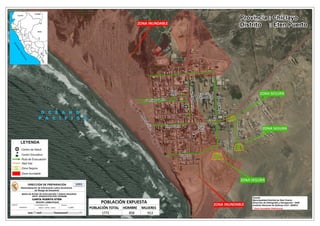
- 1. Source: Esri, DigitalGlobe, GeoEye, Earthstar Geographics, CNES/Airbus DS, USDA, USGS, AeroGRID, IGN, and the GIS User Community O C É A N O O C É A N O P A C Í F I C O P A C Í F I C O S S S ZONA INUNDABLE Provincia : Chiclayo Distrito : Eten Puerto ZONA INUNDABLE ZONA SEGURA ZONA SEGURA ZONA SEGURA LAMBAYEQUE BRASIL COLOMBIA ECUADOR B O L I V I A C H I L E O C É A N O P A C Í F I C O FUENTE: ESCALA : DIRECCIÓN DE PREPARACIÓN INDECI - DIPRE - SIERD ELABORADO POR: 1:2,900 DHN/INDECI Sistematización de Información sobre Escenarios de Riesgo de Desastres MAPA DE RUTAS DE EVACUACIÓN Y ZONAS SEGURAS ANTE INUNDACIÓN POR TSUNAMI 0 0.1 0.2 0.3 0.4 0.05 Km CARTA PUERTO ETEN REGIÓN LAMBAYEQUE n C Ruta de Evacuación Zona Segura Zona Inundable S Red Vial LEYENDA n C Centro de Salud Centro Educativo Fuente: Municipalidad Distrital de Eten Puerto Dirección de Hidrografía y Navegación - DHN Instituto Nacional de Defensa Civil - INDECI * Zona Inundable Referencial Estación Ferroviaria Garcia y Garcia Plaza Grau Diego Ferre Parque Juan Mejia S á n c h e z P e ñ a Huascar Do s de M ay o M a l e c ó n E t e n POBLACIÓN TOTAL HOMBRE MUJERES 1771 858 913 POBLACIÓN EXPUESTA