Australia and New Zealand
•Als DOCX, PDF herunterladen•
0 gefällt mir•37 views

A brief interesting information about the continent of Australia and New Zealand.

Empfohlen
Weitere ähnliche Inhalte
Was ist angesagt?
Was ist angesagt? (18)
Ähnlich wie Australia and New Zealand
Ähnlich wie Australia and New Zealand (20)
Kürzlich hochgeladen
Kürzlich hochgeladen (20)
Australia and New Zealand
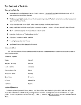
- 1. The Continent of Australia Discovering Australia Dutch explorersfirstsightedAustraliainearly17th century. Capt.JamesCook exploredthe eastcoastin1770 and claimedthe landforGreat Britain. The Discoveryof Gold and othermineralsattracted immigrants,ButAustraliaremainedprimarilyanagricultural countryuntil WorldWar II. Today Australiaranksasone of the world’smosteconomicallydevelopedcountries. One of the sevencontinentsof the world,consideredthe world’ssmallestcontinent andsixthlargestcountry. “Terra AustralisIncognita”meansUnknownSouthernLand. Australia,alsoknownas“The Land DownUnder” Kangaroois endemicintheirContinent. It has highproportionof drylands. Unique Varietiesof Vegetationandanimal life. Early Australians The Aborigines people of Australia,descendedfromgroupsthatexistedinAustraliaandsurroundingislandsprior to British Colonisation. 7 States of Australia States Capitals NorthernTerritory Darwin SouthAustralia Adelaide WesternAustralia Perth NewSouthWales Sydney Queensland Brisbane Victoria Melbourne Tasmania Hobart Land and Resources Australiaisprimarilyaflatlow-flyingplateau,withabout95% of the landstandinglessthan1, 970 feetabove sea level.The Continentwasnotaffectedbyrecentgeological mountain-buildingforces,andall itslandformsare highly eroded.Australia’sHighestmountainsreachonly2,228 m. (7, 310 feet) in MountKosciusko inSoutheasternNewSouth Wales.
- 2. Onlythe reddesertloamshave farmingpotentials.Australiacanbe dividedphysicallyintothreemainparts,the high groundand plateauin the west,the interiorlowlandsinthe middle,andthe mountainrangesinthe east.Much of the countryis very dry,and inthe central andwesternregions,there are large areasof deserts.Onlyinthe eastisthe climate suitable forgrowingwheat,oats,fruitsandhuge sheepfarmsthatmake Australiathe world’slargestwool producer. The Uluru or Ayers Rock Uluru, or Ayers Rock, is a massive sandstone monolith in the heart of the Northern Territory’s arid "Red Centre". The nearest large town is Alice Springs, 450km away. Uluru is sacred to indigenous Australians and is thought to have started forming around 550 million years ago. It’s within Uluru-Kata Tjuta National Park, which also includes the 36 red-rock domes of the Kata Tjuta (colloquially “The Olgas”) formation. Climate in Australia Australiais a continent that experiencesavariety of climates due to itssize.The temperature can range from belowzero inthe Snowy Mountains in southernAustraliato extreme heatin the Kimberleyregioninthe north-west of the continent.There is a Summer/ Autumn/ Winter / Spring pattern in the Temperate zone,also affectingthe Desert and the Grassland climatic zonesand, a Wet / Dry pattern in the tropical north whichincludesthe Equatorial, Tropical and sub-tropical zones. Summer: Decemberto February Autumn: March to May Winter: June to August Spring: Septemberto November Water Forms The territory is a possession of Australia, administered from Canberra by theAustralian Department of the Environment. The Tasman Sea is the large body of water between Australia and New Zealand and is a south- western segment of the South Pacific Ocean. LongestRiver- The MurrayRiver is Australia's longest river, at 2,508 kilometres (1,558 mi) in length. Deepest Lake - Lake St Clair with a maximum depth of 200 m is Australia's deepest lake. Top 5 Tourist Attractions 1. SydneyOpera House - Mention"Sydney,Australia"andmostpeoplethinkof the OperaHouse andone of the world'sgreatarchitectural icons. 2. Great Barrier Reef - WorldHeritage-listedGreatBarrierReef isone of the largestlivingstructureson the planet. 3. Uluru-Kata Tjuta National Park - Deepinthe heart of the Australia'sRedCentre, Uluru(formerly AyersRock),is one of the mostphotographednatural wondersinthe country. 4. SydneyHarbour Bridge - Alongwiththe OperaHouse,the SydneyHarbourBridge isone of Australia'smost famousicons.Affectionatelycalled"the Coathanger",thisimpressive featof constructionisthe largeststeel arch bridge inthe world. 5. Blue Mountains National Park - A UNESCOWorld Heritage Site,beautifulBlue MountainsNational Parklies81 km westof Sydneyandisa populardaytripfrom the city.
- 3. New Zealand It is a country in the southwestern Pacific Ocean consisting of 2 main islands, both marked by volcanoes and glaciation. Capital Wellington, on the North Island, is home to Te Papa Tongarewa, the expansive national museum. NewZealandissituatedsome 1,500kilometres(900mi) eastof Australia across the Tasman Seaand roughly1,000 kilometres(600 mi) southof the Pacificislandareasof New Caledonia,Fiji,andTonga.Because of itsremoteness,itwas one of the lastlandsto be settledbyhumans. The Maori People Māori are the tangata whenua,the indigenouspeople,of New Zealand.Theycame here more than1000 yearsago fromtheirmythical Polynesianhomelandof Hawaiki.TodayMāori make up 14% of our populationandtheir history, Language andTraditionsare central to New Zealand’sidentity. Climate of NewZealand New Zealand has a largely temperate climate. While the far north has subtropical weather during summer, and inland alpine areas of the South Island can be as cold as -10 C in winter, most of the country lies close to the coast, which means mild temperatures, moderate rainfall, and abundant sunshine. Spring (September–November) Autumn / Fall (March – May) Summer (December–February) Winter(June – August) Economy The agricultural,horticultural, forestry,miningandfishingindustriesplayafundamentallyimportantrole inNew Zealand's economy,particularlyinthe exportsectorandinemployment.Overall,the primarysectoraccountsfor7.6% of GDP andcontributesover50% of NewZealand'stotal exportearnings. Throughthe rest of NewZealand, sheepfarmingisthe majorrural activity,withbeefcattle farminginthe hillsand highcountry,and dairyingincreasinginCanterbury,OtagoandSouthland.New Zealandisthe world'seighthlargestmilkproducer,withabout2.2% of worldproduction. Landforms Mountainsdominate large areasof the NewZealandlandscape.About60% of the SouthIslandiscoveredbyranges withpeaksover1,500 metreshigh.Some peaksinthe Aoraki/Mt Cook regionof the central Southern Alpsare more than twice thisheight. Aoraki / Mount Cook isthe highestmountaininNew Zealand.Itsheightsince 2014 is listedas 3,724 metres(12,218 feet),downfrom3,764 m (12,349 ft) before December1991, due to a rockslide andsubsequent erosion.Itliesinthe SouthernAlps,the mountainrange whichrunsthe lengthof the SouthIsland.
- 4. Water Forms Waters in New Zealand. In New Zealand, there are more than 425,000 km of rivers and streams, about 4,000 lakes and over 200 underground aquifers. Annual water flow is 145 million litres per person. Longest rivers - The longest river in New Zealand is the Waikato River with a length of 425 kilometres (264 mi). Deepest Lake - Hauroko Lake. Hauroko Lake is the deepest lake in New Zealand and 23rd deepest in the World, Largest Lake - Lake Taupo. Lake Taupo is the largest lake in New Zealand, so large, in fact, that it is the size of Singapore. Tourist Attractions 1. Fiordland National Park and Milford Sound, South Island - A WorldHeritage Site, FiordlandNational Park protectssome of the most spectacularsceneryinthe country.Glacierssculptedthisdramaticlandscape carvingthe famousfjordsof Milford,Dusky,andDoubtful Sounds. 2. Bay of Islands, North Island - A three-hourdrive northof Auckland,the beautifulBayof Islandsisone of the most popularvacationdestinationsinthe country.More than144 islandsdotthe glitteringbaymaking it a havenfor sailingandyachting. 3. Queenstown, South Island - Snuggledbetweenthe shoresof shimmeringLake Wakatipuandthe snowy peaksof the Remarkables, Queenstown isNew Zealand'sadventurecapital andone of the country'stop destinationsforinternational visitors. 4. Lake Taupo and TongariroNational Park, North Island - Inthe centerof the NorthIsland,afew kilometersfromglitteringLake Taupo,New Zealand'slargestlake,TongariroNational Parkisadual World Heritage Site due toitsspectacularvolcanicfeaturesanditsimportance tothe Maori culture. 5. Rotorua, North Island - Onthe tumultuousPacificRingof Fire, Rotoruaisone of the mostactive geothermal regionsinthe world.Thisisalandwhere the earthspeaks.Boilingmudpools,hissinggeysers, volcaniccraters,and steamingthermal springsbetraythe forcesthat birthedmuchof New Zealand's dramatictopography. 6. Fox and Franz JosefGlaciers,South Island - Amongthe most accessible glaciersinthe world,FranzJosef and Fox glaciersare the maintouristattractionsinspectacularWestlandTai Poutini National Park. 7. Abel Tasman National Park and the Abel Tasman Coast Track, South Island - The Abel TasmanCoast Track in Abel TasmanNational Parkisone of New Zealand's GreatWalks.Windingalongsparkling Tasman Bay, fromMarahau to SeparationPoint,thisscenic51-kilometerhike liesinone of the sunniestregionsof the SouthIsland. 8. Aoraki / Mount Cook National Park, South Island -Inthe heartof the SouthernAlps,NewZealand's highestpeaksrise above the alpinelandscapesof Aoraki NationalPark,alsocalledMountCookNational Park. More than 40 percent of the parkis coveredinglaciers,andthe country'stallestmountain Aoraki/Mount Cookand longestglacier,the TasmanGlacier,lie withinitsbordersmakingthisatopdestinationfor mountaineering. 9. Napier, Hawke's Bay, North Island - Inthe sunnyregionof Hawke'sBay, Napierisfamousforits gourmet foodand Art Decoarchitecture.After apowerful earthquake destroyedthe townin1931, it wasrebuiltinthe SpanishMissionstyle andArtDecodesignforwhich Miami Beach isalsofamous. 10. Coromandel Peninsula, North Island - Justacrossthe Hauraki Gulf fromAuckland,the rugged Coromandel Peninsulaseemsaworldawayfromthe city'shustle andbustle.