Jaipur ,urban planning
•Download as PPTX, PDF•
8 likes•7,156 views

urban planning, demographic profile,architectural plan,master plan, land-use development

Recommended
Recommended
More Related Content
What's hot
What's hot (20)
Similar to Jaipur ,urban planning
Similar to Jaipur ,urban planning (20)
More from SuchetanaChakravarty
Recently uploaded
Recently uploaded (20)
Jaipur ,urban planning
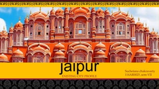
- 1. jaipurEXISTING CITY PROFILE Suchetana chakravarty 114AR0025 ,sem-VII
- 2. introduction • Jaipur (जयपुर), is the capital and largest city of the Indian state of Rajasthan. • It was founded on 18 November 1727 by Maharaja Sawai Jai Singh II, the city has been named after him. • The city today has a population of 3.1 million. • Jaipur is also known as Pink City and Paris of India
- 3. Location: 26.92°N 75.82°E Altitude: 431 m (1417 ft.) Above MSL. Area: 484.64 km2 Population : 3,046,189 Density: 6,300/km2 Jaipur city is Rajasthan’s capital and largest city. Jaipur is situated in the eastern border of Thar Desert. It is 258 kms from Delhi and 232 kms from Agra,it forms a Golden Triangle to attract tourists. Languages : Official: Hindi Regional: Rajasthani Climate: Jaipur has hot dry summer and cold winter with mean maximum temperature of 45 C and the mean minimum temperature of 5 C. The average annual rainfall is 595.3 mm.
- 4. History • The city of Jaipur was founded in 1726 by Jai Singh II, the Raja of Amer who ruled from 1699 to 1743. • He planned to shift his capital from Amer, 11 kilometres (7 mi) from Jaipur to accommodate the growing population and increasing scarcity of water • Under the architectural guidance of Vidyadhar Bhattacharya, • Jaipur was planned based on the principles of Vastu shastra and Shilpa Shastra • The city was divided into nine blocks, two of which contained the state buildings and palaces, with the remaining seven allotted to the public. • Huge ramparts were built, pierced by seven fortified gates
- 5. Conceptual prastara plan • it is a model of town planning- the first planned city in india. it is based on hindu systems of town planning and followed the principles prescribed in the shilpa-shastra. according to this shastra the site should be divided into grids or mandalas ranging from 2x 2 to 10 x 10. planned according to the prastara type of layout, which gives prominence to the cardinal directions. thus plan of jaipur is a grid of 3x3 with gridlines being the city’s main streets.
- 6. • The city’s division into nine wards was also in conformity with the Hindu caste system, which necessitated the segregation of people belonging to different communities and ranks. Following the directions of the Hindu Shilpa shastra, width of the main streets & other lanes were fixed. Thus the main streets of the city were 111ft. wide, secondary streets 55 ft. wide & the smaller ones 27ft. wide.
- 7. Growth of jaipur :-
- 8. Demographic profile Population: • Jaipur city population (as per 2001 census): 23.23 lakh • Population(as per 2011 census): 36.02 lakh • Projected population(2025): 64.95 lakhs Natural growth and In-migration
- 9. Sex ratio: The sex ratio is very low, per 1000 male only 876 female Elderly and children population
- 10. Literacy rate : the city does not give a healthy picture when it comes to literacy rate though at present there is increment in literacy rate
- 11. Employment : Jaipur has 30% (3079) population engaged in either main or marginal works. 46% male and 13% female population are working population. 39% of total male population are main (full time) workers and 7% are marginal (part time) workers. For women 7% of total female population are main and 6% are marginal workers. Economy
- 12. Housing Households & housing units : 4.2 % of housing are semi-permanent and .94% are temporary Housing supply in jaipur: Housing shortage : The housing shortage for 2001 is 1,44,042
- 13. Industry • Organized Industrial areas- V.K.I.A., Jhotwara, Kanakpura, Bindayaka Sitapura and Sanganer. • Unorganized Industrial areas- mainly concentrated in the Sanganer town • Household Industry- mostly in walled city. • Master Plan 1991 proposed 1805 Ha, however development could be taken place in 1007 Ha. • Master Plan 2011 proposed 1862 Ha. however 1600 Ha. Developed.
- 14. Main industrial products: ball bearing, ceramics ,dyeing ,pottery, engraving on brass ,printing, ferrous, nonferrous material casting, marble statues, slabs, tiles, food products , gems and jewellery ,electrical appliances, PVC units Industry Export items: Brass ,lacquer work , enamel work ,handloom, gems& jewellery ,marble tiles
- 15. Administrative profile • Jaipur Municipal Corporation is responsible for maintaining the city's civic infrastructure and carrying out associated administrative duties. • The Municipal Corporation is headed by a mayor. • There are 91 wards and each ward is represented by an elected member. • Jaipur Development Authority (JDA) is the nodal government agency responsible for the planning and development of Jaipur. • Jaipur consists of two parliamentary constituencies Jaipur and Jaipur Rural. Rajasthan Vidhan Sabha
- 17. Transportation road network :- • the transport system of Jaipur city is mainly road based. • The road network inside the walled city is different from outside areas. • The walled city has a grid pattern of roads • Road follows a hierarchy • Major roads are east-west(surajpol-Chandrapol),they are 33 m wide • Following the major roads,16.5 m wide roads runs through north to south ,linking internal areas • jaipur city has around 10 major arterial spines that criss-cross the entire city. tonk road is a major arterial road that connects some of the major employment centers like sanganer, durgapura and lal kothi.
- 18. CHAUPAR – It’s a square that occurs at the intersection of east west roads with three north south roads. Each chaupar is around 100m x 100m. Were used for public gathering on festive occasions. The distance between two chaupars is about 700m which is ideal for pedestrian movement.
- 19. Transportation Vehicle Growth :- Modal split of the Jaipur city :-
- 20. Transportation TRANSPORT DATA ANALYSIS • Public transport buses are operated by Rajasthan State Road Transport Corporation(RSRTC) • RSRTC operates all rajasthan more than 5000 buses and over 13,000 buses to al important places in rajasthan adjoin states Gujrat, Haryana, Punjab, Delhi, Uttar Pradesh. • 4 gov. bus depos namely vaishali, sanganer,jhalana, vidhyadhar nagar • At present 185 bus routes operating in the city. PUBLIC TRANSPORTATION SYSTEM AND OPERATION • A road network of 600 km lenghth including arterial, sub-arterial and other important roads. • 18% ROW less than 30 m • 32% have 30m ROW • 50% have ROW in acess of 30 m. • Footpath has been found missing in majority of the roads
- 21. Transportation METRO NETWORK • Jaipur Metro is a rapid transit system in the city of Jaipur, • comprising 9.63 kilometres (5.98 mi) of route from Mansarovar to Chandpole Bazaar • Construction started on 13 November 2010 and was completed in 2014
- 22. Transportation AIR NETWORK • Existing railway station handling about 80,000 passengers per day. • Railway station is the most congested part of the city , limited scope of improving. • Present land available 716 acres. • Passenger traffic increases by 77% in 2005-2006 • Conncted via air to : new delhi, Mumbai, agra, Kolkata, Chennai, alhabad, cochin,jaisalmeer, Bengaluru, goa ,dubai, muscat RAIL NETWORK
- 24. Socio cultural infrastructure Nahargad Jantar mantar Raj mandir –cinema hallJwarlal kala kendra
- 25. Physical infrastructure WATER SUPPLY • The city is covered with municipal water supply. • City has adequate water supply with an availability126.5 lpcd covering more than 86.5% population. • The main source of water is ground water, which is fast depleting at the rate of 3m/annum. • Walled city: there are 5 no. of clear water reservoir & 5 no. of ESR • Northern part: 31 no. of service reservoirs • Southern part: 64 no. of service reservoirs Bisalpur Dam Bisalpur water channel
- 26. Physical infrastructure DRAINAGE • The drainage network of Jaipur includes 9 nallah/river • Municipal area divided into 19 drainage zones • All the nala drain into amanishah nalla .it discharges into dhund river which joins Bans river.
- 27. Physical infrastructure SEWERAGE :- • The existing sewerage system covers about 65 % of total area of Jaipur. In the areas uncovered by sewerage system septic tanks • Municipal area divided into 8 zones. • The city generates 200 MLD sewage. • Septic tanks cater to 25% of population in Jaipur • Roughly 1,20,600 septic tanks are in Jaipur. • Two sewage treatment plants constructed by Jaipur municipal corporation. Bhrampuri (north)- 27MLD capacity dehlawas(south)- 62.5 MLD capacity Dehlawas
- 28. Solid waste management Type of waste generated can be classifies : 1. Msw 2. Biomedical waste 3. Industrial waste 4. Construction & demolition Genrates 1040 metric tones per day • Collected in traditional tricycles,they deposited into open sites,round cement concrete bins • Transportation of waste done through dumper placer, tractor ,trucks, hand carts. Processing : • RDF plant installed of capacity 15000tonns/month , where input is 12000 tons/month • No energy project/vermi composting
- 31. THANK YOU