SlideShare a Scribd company logo
1 of 94
Download to read offline
Fermanagh & Omagh
Walking
Guide
Your essential guide to walking in
the Fermanagh and Omagh District
Disclaimer
Every care has been taken to ensure accuracy in the
compilation of this guide. The information provided is, to
the best of the promoter’s knowledge correct at the time of
going to print. The promoters cannot accept responsibility
for any errors or omissions but if they are brought to their
notice, future publications will be amended accordingly.
All maps are Crown Copyright and are reproduced with the
permission of Land & Property Services under delegated
authority from the Controller of Her Majesty's Stationery Office,
© Crown Copyright and database right 2016 CS&LA156.
More detailed maps can be sourced from www.walkni.com
For specific queries regarding this publication or more
general enquiries about access to the countryside
and walking in the Fermanagh and Omagh District
contact Fermanagh and Omagh District Council:
Enniskillen: +0044 (0) 300 303 1777
Email: countryside@fermanaghomagh.com
Plan ahead and prepare
Maps in this guide are for illustrative purposes only. For
those moderate and difficult walks it is advised that you
obtain detailed maps before walking. Please ensure you are
correctly equipped with suitable clothing and foot wear.
Some of these walks are in truly natural surroundings,
including steep ground, rocky scree, uneven surfaces and
boggy sections – you are responsible for your own safety.
www.fermanaghomagh.com
Leave No Trace
In order to minimise your social and environmental
impacts on the outdoors, please follow the
Seven Principles of Leave No Trace:
1. 	 Plan Ahead and Prepare
2. 	 Be Considerate of Others
3. 	 Respect Farm Animals and Wildlife
4. 	 Travel and Camp on Durable Ground
5. 	 Leave What You Find
6. 	 Dispose of Waste Properly
7. 	 Minimise the Effects of Fire
The walks have been graded into three categories:
	Easy 	 Short walks generally fairly level going on 	
		 well surfaced routes
	Moderate 	Longer walks with some gradients and 		
		 generally on well surfaced routes
	 Difficult 	 Longer walks only suitable for more 	
		 experienced walkers correctly equipped
	 	 with waterproof clothing and strong
		 walking boots
Additional Information
An Creagán Trails
©FODC
❚ Nearest Town
Carrickmore / Omagh
❚ Points of Interest
Rich diversity of species,
particularly on the
raised bog
❚ Location
An Creagán Centre is
located on the main road
between Omagh and
Cookstown.
❚ Distance
0.25 miles / 3.4 miles
❚ Route Shape
Circular
❚ Route Type
Forest, riverside
❚ Facilities
Café, shop, visitors centre
and toilets are on site.
Overview
There are a number of trails on site taking in a variety of
the habitats that makes An Creagán a haven for wildlife.
You can choose from the Biodiversity trial, 0.25 miles, or
if you want something a bit more challenging opt for the
Forest and River Trail, 3.4 miles.
Take a journey in the company of some of the most
fascinating wildlife and stunning scenery.
Trails are suitable for buggies and bikes.
❚ Contact: www.an-cregan.com
An
Creagán
Trails
Easy to Moderate
Grade of Walk
©AnCreagán
Ballintempo Forest:
Aghanaglack Walk
©MACGG
❚ Nearest Town
Enniskillen
❚ Points of Interest
The dual court tomb at
Aghanaglack - this ritual
burial site dates from the
Neolithic period between
4,000 and 2,000 years B.C.
❚ Location
Access to the small car-
park at Aghanaglack from
Belcoo is five miles via
the Aughrim Road and
Gaedrum Road following
signage to the chambered
cairn
❚ Distance
7 miles
❚ Route Shape
Circular
❚ Route Type
Forest, woodland
❚ Facilities
Car parking available,
nearest amenities Belcoo
Overview
Aghanaglack Walk takes you through one of the largest
continuous forestry tracts in Northern Ireland, mostly
along forest tracks and with few gradients. This lengthy,
yet comfortable walk offers impressive views across
Lough MacNean to Cuilcagh Mountain. The most
significant feature of this walk is the Aghanaglack Dual
Court Tomb.
(Part of the Marble Arch Caves Global Geopark)
❚ Contact: www.marblearchcavesgeopark.com
Ballintempo
Forest:
Aghanaglack
Walk
Moderate
Grade of Walk
©MACGG
Bellanaleck
Loughshore Walk
©FODC
❚ Nearest Town
Bellanaleck
❚ Points of Interest
Bellanaleck ASSI, range of
Biodiversity
❚ Location
The entrance to Waterhen
Lane will be on your left
handside, just after the
30 mph speed zone upon
entering Bellanaleck from
Enniskillen
❚ Distance
1.6 miles
❚ Route Shape
Circular
❚ Route Type
Lakeland, urban
❚ Facilities
Public toilets are on
the route. Play park for
children. Bellanaleck
village is a few 100meters
away. Shop and tea rooms
are available in town
Overview
The natural habitats of Bellanaleck are home to a rich
array of native biodiversity which can be viewed along
this walk; majestic oak trees, species rich grassland and
open water to name a few.
During the summer an impressive explosion of common-
spotted orchids can be viewed along the road verge.
This walk is also close to Bellanaleck ASSI, noted for its
geological importance.
❚ Contact: www.fermanaghomagh.com
Bellanaleck
Loughshore
Walk
Easy
Grade of Walk
©FODC
Belmore Forest:
Pollnagollum Cave Walk
©MACGG
Belmore
Forest:
Pollnagollum
Cave
Walk
❚ Nearest Town
Enniskillen
❚ Points of Interest
Pollnagollum Cave,
waterfall
❚ Location
Belmore Forest Car Park
❚ Distance
4.3 miles
❚ Route Shape
Circular
❚ Route Type
Forest, woodland
❚ Facilities
Information panel and car
parking available, nearest
amenities Boho
Overview
The Pollnagollum/Coolarkan Cave Walk through Belmore
Forest is at the heart of Fermanagh’s Boho cave country.
The walking route is mostly along forest tracks and offers
stunning landscapes and views of Belmore Mountain.
The highlight of the walk is Pollnagollum Cave - meaning
‘hole of the doves’, which was recently used in filming the
popular television series 'Game of Thrones'.
A viewing platform at the caves provides a great vantage
point to see the impressive cave entrance which is fed
by a cascading waterfall toppling down a 12 metre
limestone cliff to disappear into the depths of darkness.
(Part of Marble Arch Caves Global Geopark)
❚ Contact: www.marblearchcavesgeopark.com
Easy
Grade of Walk
©MACGG
Bessy Bell
©IMC
Bessy
Bell
❚ Nearest Town
Omagh / Newtownstewart
❚ Points of Interest
Holy well, wind farm
❚ Location
Car park is situated at
the Mellon Country Inn
(A5 between Omagh and
Newtownstewart)
❚ Distance
2.8 miles (one way)
❚ Route Shape
Linear
❚ Route Type
Road, gravel track and
open grassland
❚ Facilities
Facilities are available at
the Mellon Country Inn or
nearest towns in Omagh
or Newtownstewart
Overview
Bessy Bell is a pleasant and interesting walk showcasing
the beautiful and unique terrain of the Sperrins
landscape. Starting at the Mellon Country Inn the track
travels along the main road before turning uphill
on a country lane. The linear track ascends the summit
through a variety of tarmac, rough grassland and heather,
where walkers will be rewarded with panoramic views
of the surrounding area.
❚ Contact: www.fermanaghomagh.com
Difficult
Grade of Walk
©IMC
Big Dog Forest:
Big Dog Walk
©MACGG
❚ Nearest Town
Derrygonnelly
❚ Points of Interest
Possibly the most
intriguing features along
the walk are the two hills
Big Dog and Little Dog
❚ Location
The car park is adjacent
to the Knockmore Road
approximately eight miles
from Derrygonnelly village,
at the south side of the
Doagh Road between
Derrygonnelly and
Garrison
❚ Distance
2.5 miles
❚ Route Shape
Circular
❚ Route Type
Forest, lakeland,
woodland
❚ Facilities
Car parking and picnic
area available, nearest
amenities Derrygonnelly
Overview
Big Dog Forest gets its name from the larger of the two
small hills that dominate the skyline, known as Big Dog
and Little Dog. Their names originate from Irish folklore
as they are named after Bran and Skeola (Sceolan), two
favourite Irish wolfhounds belonging to the legendary
giant Finn McCool. One day while out hunting, the dogs
picked up the scent of a witch and gave chase. To aid her
escape the witch changed herself into a deer but the two
dogs still gained ground on her, so in desperation she
cast a spell turning them both into solid rock.
(Part of the Marble Arch Caves Global Geopark).
❚ Contact: www.marblearchcavesgeopark.com
Big
Dog
Forest:
Big
Dog
Walk
Easy
Grade of Walk
©MACGG
Carrigan Forest:
Lough Formal Walk
©MACGG
Carrigan
Forest:
Lough
Formal
Walk
❚ Nearest Town
Derrygonnelly
❚ Points of Interest
Lough Formal
❚ Location
Coming from Enniskillen,
approximately 10km from
Derrygonnelly, take the
lane on the right signed for
Big Dog car park
❚ Distance
7 miles
❚ Route Shape
Circular
❚ Route Type
Forest, lakeland,
woodland
❚ Facilities
Information panel. Car
parking available in
car park for Big Dog
Forest, nearest amenities
Derrygonnelly
Overview
Carrigan Forest is situated approximately 12km outside
the village of Derrygonnelly. It is the gateway between
two significant expanses of upland forest, tucked
between Big Dog Forest and Ballintempo Forest.
Carrigan Forest showcases a landscape rich in limestone
features.
The Lough Formal walk is almost all on forestry tracks
and features a short path through the heather to the
summit of Formal More.
(Part of the Marble Arch Caves Global Geopark).
❚ Contact: www.marblearchcavesgeopark.com
Moderate
Grade of Walk
©MACGG
Castle Archdale Forest:
Woodland Riverside Walk
©MACGG
❚ Nearest Town
Kesh/Irvinestown
❚ Points of Interest
The forest is a richly varied
one in terms of views
and features and includes
ruined castles and ancient
woodland
❚ Location
Take the B82 from
Enniskillen to Kesh,
follow signposts to Castle
Archdale Country Park
❚ Distance
0.5 miles
❚ Route Shape
Circular
❚ Route Type
Forest, riverside,
woodland
❚ Facilities
Picnic facilities and
information panel.
Additional facilities
are located at the
Countryside Centre within
Castle Archdale Forest
which include parking,
information centre, toilets
and restaurant
Overview
Castle Archdale Forest is a 520 hectare mixed
broadleaved and coniferous lowland forest located on
the eastern shores of Lower Lough Erne. The forest is
a richly varied one in terms of views and features and
includes ruined castles, WWII docks & buildings, ancient
woodland and views over Lower Lough Erne to White
Island, Davy's Island and further afield.
(Part of the Marble Arch Caves Global Geopark).
❚ Contact: www.marblearchcavesgeopark.com
Castle
Archdale
Forest:
Woodland
Riverside
Walk
Easy
Grade of Walk
©MACGG
Castle Archdale Forest:
Tom’s Island Walk
©MACGG
Castle
Archdale
Forest:
Tom’s
Island
Walk
❚ Nearest Town
Kesh/Irvinestown
❚ Points of Interest
Lough Erne
❚ Location
Take the B82 from
Enniskillen to Kesh,
follow signposts to Castle
Archdale Country Park
❚ Distance
1.8 miles
❚ Route Shape
Circular
❚ Route Type
Forest, loughshore
❚ Facilities
Picnic facilities and
information panel.
Additional facilities
are located at the
Countryside Centre within
Castle Archdale Forest
which include parking,
information centre, toilets
and restaurant
Overview
Tom’s Island trail in Castle Archdale is one of the finest
spots to appreciate the stunning beauty of Lower Lough
Erne. Start off by exploring the ruins of Old Castle
Archdale, an impressive fortification built in 1612 when
the Archdale family arrived in Ireland from Suffolk,
England. The path then leads you along the river before
the wide expanse of Lower Lough Erne opens up in front
of you. You’ll then skirt the lough shore through dense
woodland with incredible views of White Island and Davy’s
Island. You will notice Tom’s Island is not actually an island
however, before the lough was lowered many years ago it
was cut off from the mainland by a shallow strip of water.
(Part of the Marble Arch Caves Global Geopark).
❚ Contact: www.marblearchcavesgeopark.com
Easy
Grade of Walk
©MACGG
Castle Caldwell Forest:
Beechwood Walk
©MACGG
❚ Nearest Town
Belleek
❚ Points of Interest
Castle Caldwell ruins
❚ Location
Turn off Kesh – Belleek
A47 road about 8km
from Belleek into Castle
Caldwell Forest
❚ Distance
1.2 miles
❚ Route Shape
Circular
❚ Route Type
Forest
❚ Facilities
Car parking and picnic
facilities. Amenities
available in Belleek
village, approximately
5mile away.
Overview
The Beechwood Walk is part of the Marble Arch Caves
Global Geopark and encompasses both lough shore
and woodland paths. The walk takes in man-made and
natural wonders, including a lime-kiln which hints at
the association of the Caldwell estate with the nearby
Belleek Pottery, a half-moon limestone bench along the
shoreline and the eerie ruins of Castle Caldwell.
(Part of the Marble Arch Caves Global Geopark).
❚ Contact: www.marblearchcavesgeopark.com
Castle
Caldwell
Forest:
Beechwood
Walk
Easy
Grade of Walk
©IMC
Castle Caldwell Forest:
Castle Scenic Walk
©MACGG
Castle
Caldwell
Forest:
Castle
Scenic
Walk
❚ Nearest Town
Belleek
❚ Points of Interest
Castle Caldwell ruins
❚ Location
Turn off Kesh – Belleek
A47 road about 8km
from Belleek into Castle
Caldwell Forest
❚ Distance
0.3 miles
❚ Route Shape
Circular
❚ Route Type
Forest
❚ Facilities
Car parking and picnic
facilities. Amenities
available in Belleek
village, approximately
5mile away
Overview
The Castle Scenic Walk offers a gentle and appealing
introduction to the Castle Caldwell estate. A series of
forest tracks zig-zag through this ancient woodland
area where views are dominated by the castle ruins.
After passing through a section of walled garden, you
will reach a gravel track leading to the foot of the ivy
clad ruins of the old castle. Although the castle was
eventually abandoned in the 1900’s, if local ghost stories
are to be believed, the ruins are still haunted by Dennis
McCabe, a fiddler who drowned after falling off the
Caldwell family barge. A copy of the fiddler’s grave stone
with its amusing inscription can be seen at the main
entrance to the forest park.
(Part of the Marble Arch Caves Global Geopark).
❚ Contact: www.marblearchcavesgeopark.com
Easy
Grade of Walk
©IMC
Castle Caldwell Forest:
Rossergole Point Walk
©MACGG
Castle
Caldwell
Forest:
Rossergole
Point
Walk
❚ Nearest Town
Belleek
❚ Points of Interest
Castle Caldwell ruins,
Lime Kiln
❚ Location
Turn off Kesh – Belleek
A47 road about 8km
from Belleek into Castle
Caldwell Forest
❚ Distance
2.5 miles
❚ Route Shape
Circular
❚ Route Type
Forest, lakeland
❚ Facilities
Car parking and picnic
facilities. Amenities
available in Belleek village,
approximately 5mile away
Overview
This popular path takes in the remnants of the estate’s
castle, forts, defence walls, jetties and lime kiln. Walkers
who take time to explore the area will find the industrial-
scale lime kiln highlighting the importance of the local
limestone, once frequently fired in the kiln to produce
quicklime, and taken by barge to the nearby town of
Belleek. Another interesting feature which may be found
at the eastern tip of the peninsula, are the walls of the
old strategic defence fort of Rossergole Point. This
fortification no doubt played a vital role in protecting
and controlling trade along this route. Today the old ruins
offer walkers a vantage point for breathtaking views over
Lower Lough Erne.
(Part of the Marble Arch Caves Global Geopark).
❚ Contact: www.marblearchcavesgeopark.com
Easy
Grade of Walk
©MACGG
Castle Coole: Beech Walk
©CarolineJohnston
Castle
Coole:
Beech
Walk
❚ Nearest Town
Enniskillen
❚ Points of Interest
Ice House, Castle Coole
House
❚ Location
Castle Coole is located
off the A4 road to
Belfast 1.5 miles South
East of Enniskillen.
Parking is located beside
the reception and tea
room area
❚ Distance
0.5 miles
❚ Route Shape
Circular
❚ Route Type
Woodland
❚ Facilities
Car park, picnic area,
Tallow House Tea-room,
shop and toilets
(disabled access) and
children’s play area
Overview
The Beech wood forms a backdrop to the Neoclassical
mansion and contains a tranquil walk through unspoilt
nature. The wood was planted around 1709 with a mixed
group of beech, oak and scots pine. The wood still has
oak trees dating back to the early 18th century and
contains the oldest trees in the park. Visit in spring to see
a carpet of bluebells amongst the trees, and make sure to
visit the 18th century Ice House. For a longer walk, take
the adjoining Gortgonnell path.
*National Trust entrance pricing applies for this walk*
❚ Contact: www.nationaltrust.org.uk/castle-coole
Easy
Grade of Walk
©CarolineJohnston
Castle Coole: Lake Walk
©NationalTrust
❚ Nearest Town
Enniskillen
❚ Points of Interest
Castle Coole House,
Boathouse
❚ Location
Castle Coole is located
off the A4 road to
Belfast 1.5 miles South
East of Enniskillen.
Parking is located beside
the reception and tea
room area
❚ Distance
Just over 1 mile long
❚ Route Shape
Circular
❚ Route Type
Woodland, lakeland
❚ Facilities
Car park, picnic area,
Tallow House Tea-room,
shop and toilets (disabled
access) and children’s play
area
Overview
The Lake Walk forms part of the original historic track
around the lake, which was created by the 1st Earl of
Belmore in the late 18th century. It provides a number
of beautiful vistas across the lake - keep an eye out for
the resident swans! This part of the estate is a protected
conservation site, so please keep dogs on leads where
signage suggests. Make a detour to the lake edge to take
in views of the house and surrounding countryside.
*National Trust entrance pricing applies for this walk*
❚ Contact: www.nationaltrust.org.uk/castle-coole
Castle
Coole:
Lake
Walk
Easy
Grade of Walk
©CarolineJohnston
Correl Glen
©HannahNorthridge
Correl
Glen
❚ Nearest Town
Derrygonnelly
❚ Points of Interest
Large silverwashed
fritillary, Lough views
❚ Location
Follow signs for Lough
Navar Forest Drive
signposted from A46 and
B82
❚ Distance
1 mile
❚ Route Shape
Circular
❚ Route Type
Woodland
❚ Facilities
Car park, interpretation.
Nearest amenities in
Derrygonnelly
Overview
The Correl Glen is a designated nature reserve containing
a delightful nature trail just across the road from the
entrance to Lough Navar Forest. The glen is dominated
by native woodland where a combination of birch,
oak, ash and holly trees cloak a ravine that has been
carved by the fast flowing Sillees River, which is home
to freshwater crayfish. A variety of species of butterfly
and damselfly, most notably the silver-washed fritillary,
the largest butterfly on the island of Ireland, can be seen
here during the spring and summer months.
❚ Contact: www.daera-ni.gov.uk/northern-ireland-
environment-agency
Easy
Grade of Walk
©TimFlaherty
Crocknagrally Forest
©IMC
Crocknagrally
Forest
❚ Nearest Town
Fivemiletown
❚ Points of Interest
Colebrooke River
❚ Location
The start of the walk
is at the entrance to
Crocknagrally Forest -
located on the Mullaghfad
Road approximately one
mile from the Mullaghfad/
Alderwood Road junction
❚ Distance
4.2 miles
❚ Route Shape
Circular
❚ Route Type
Forest
❚ Facilities
Carparking on site.
Nearest amenities
in Fivemiletown
(approximately 5 mile)
Overview
This circular walk is all on hard surface forest tracks
through Crocknagrally Forest. Crocknagrally is an upland
predominantly coniferous forest that lies between
Brookeborough and Fivemiletown. This 630 hectare
forest forms part of a larger connected mass of forests
that includes Doon, Jenkin, Knocks, Tully, Mullaghfad,
Carnmore, Grogey and Fardross Forests which cover 8,000
hectares spilling down from the Slieve Beagh plateau.
This walk was developed as part of the Clones Erne East
Blackwater (CEEB) Rural Regeneration project.
❚ Contact: www.fermanaghomagh.com
Moderate
Grade of Walk
©IMC
Crom
©CarolineJohnston
Crom
❚ Nearest Town
Newtownbutler
❚ Points of Interest
Crom Old Castle, boat
house, summer house,
ancient Crom yew trees
❚ Location
On Newtownbutler to
Crom road, or follow
signs from Lisnaskea (7
miles). Crom is next to the
Shannon to Erne waterway
❚ Distance
4.2 miles
❚ Route Shape
Circular
❚ Route Type
Woodland, parkland,
lakeside
❚ Facilities
Picnic area, car park,
toilets, family activity
packs and childrens
play area
Overview
Crom is one of Ireland’s most important conservation
sites and possesses the largest area of oak woodland
in Northern Ireland. Try spotting a range of wildlife
including deer, bats, wading birds, pine martens, red
squirrels and a thriving otter population. A figure-of-
eight takes you from the shores of Upper Lough Erne
past the Old Castle Ruins and on a loop around Inisherk
Island. Return via the deer park along the edge of Lough
Nalughoge. Appropriate footwear is necessary as parts of
the route can be on soft ground.
*National Trust entrance pricing applies for this walk*
❚ Contact: www.nationaltrust.org.uk/crom
Easy
Grade of Walk
©CarolineJohnston
Cuilcagh Way: Walk 1
Cladagh Glen Walk
©MACGG
❚ Nearest Town
Enniskillen / Belcoo
❚ Points of Interest
Caves, the Folly, the
Cascade
❚ Location
The Cladagh Glen car
park is signposted on
the Blacklion to
Florencecourt Road
❚ Distance
1.5 miles
❚ Route Shape
Linear
❚ Route Type
Riverside, woodland
❚ Facilities
Car park. The Visitor
Centre at the Marble Arch
is open from late March
to September, from 10.00
am-4.30/5.00 pm, with
toilets, café, shop
Overview
The Cladagh Glen Walk is a way marked linear route
through the striking landscape of the Cladagh River
gorge. Following the course of the river, this walking
route takes you through a steep limestone gorge that is
thickly covered by an ancient ash woodland. Though it
was once widespread, this sort of damp ash woodland is
now rare in Ireland and the entire gorge is protected as
part of the Marble Arch National Nature Reserve. There
are many features of interest along the route - steep
limestone cliffs, cascading waterfalls, cave springs, a
turbulent river and a rich treasury of wild flowers. The
most important feature to visit is the Marble Arch, an
impressive natural archway that spans over the river, it is
here that the Marble Arch Caves take its name.
(Part of the Marble Arch Caves Global Geopark).
❚ Contact: www.marblearchcavesgeopark.com
Cuilcagh
Way:
Walk
1
Cladagh
Glen
Walk
Moderate
Grade of Walk
©MACGG
Cuilcagh Way: Walk 2
Cuilcagh Legnabrocky Trail
©CarolineJohnston
Cuilcagh
Way:
Walk
2
Cuilcagh
Legnabrocky
Trail
❚ Nearest Town
Belcoo
❚ Points of Interest
Cuilcagh Mountain,
Cuilcagh Boardwalk
❚ Location
Follow the signs for the
Marble Arch Caves Visitor
Centre from Enniskillen.
After the Marble Arch
Caves there will be a
sign on your left handside
for the Cuilcagh
Mountain Park
❚ Distance
4.5 miles
❚ Route Shape
Linear
❚ Route Type
Mountain
❚ Facilities
Car park. The Visitor
Centre at the Marble Arch
is open from late March
to September, from 10.00
am-4.30/5.00 pm, with
toilets, café, shop
Overview
The Cuilcagh Legnabrocky Trail is a linear route which
will appeal to walkers with some experience walking
in the hills. The route is quite isolated and showcases
the scenic wilderness of Cuilcagh Mountain. The trail
meanders along a quiet farmland track before traversing
a wooden boardwalk that consists of a steady climb to
the mountain face. Here a stepped boardwalk climbs
through steep terrain and boulders fields before reaching
the summit plateau. A rough mountain path negotiates
the wild summit plateau for a few kilometres before
reaching an ancient cairn (the remains of a burial mound
dating from the Bronze Age 2,500 – 500 BC) that stands
at 666 metres above sea level.
(Part of the Marble Arch Caves Global Geopark).
❚ Contact: www.marblearchcavesgeopark.com
Difficult
Grade of Walk
©GarethMcFarland
Cuilcagh Way: Walk 3
Cuilcagh Hiker’s Trail
©MACGG
Cuilcagh
Way:
Walk
3
Cuilcagh
Hiker’s
Trail
❚ Nearest Town
Swanlinbar
❚ Points of Interest
Summit of Cuilcagh
Mountain
❚ Location
Follow the A32 out of
Enniskillen; Start point
at Gortalaughney
Viewpoint is signposted
from the road
❚ Distance
5.5 miles
❚ Route Shape
Linear
❚ Route Type
Mountain
❚ Facilities
Facilities are available at
the nearby Marble Arch
Caves Visitor Centre and
Florencecourt House
Overview
The Cuilcagh Hiker’s Trail is a way marked linear route
that will appeal to experienced walkers who enjoy
spectacular views and are interested in undertaking a
vigorous, challenging walk in the wilderness. The terrain
consists of a mountain path so some parts of the route
can be very wet and boggy, particularly after a rainy
period. Due to the often challenging weather conditions
on Cuilcagh Mountain, careful planning, constant
vigilance and good navigation are required all year round.
The trail is a richly varied one in terms of topography and
features, and includes walking over a glacial landscape
in a mountainous environment passing by dry valleys,
limestone pavement, mountain rivers and sandstone
outcrops. This area is also managed by the Royal Society
for the Protection of Birds so keep alert for signs of the
rare golden plover nesting in the area.
(Part of the Marble Arch Caves Global Geopark).
❚ Contact: www.marblearchcavesgeopark.com
Difficult
Grade of Walk
©CarolineJohnston
Cuilcagh Way: Walk 4
Legacurragh Valley Trail
©MACGG
Cuilcagh
Way:
Walk
4
Legacurragh
Valley
Trail
❚ Nearest Town
Enniskillen
❚ Points of Interest
Legacurragh Dry Valley,
Florence Court House,
Benaughlin Mountain
❚ Location
Follow the A32 out of
Enniskillen; Start point
at Gortalaughney View
point is signposted
from the road
❚ Distance
4.2 miles
❚ Route Shape
Linear
❚ Route Type
Forest, mountain
❚ Facilities
Tea rooms, shop,
picnic area, playground,
and toilets all available
in nearby Florence
Court House
Overview
The Legacurragh Valley Trail is a way marked linear route
through some of Fermanagh’s finest scenery, showcasing
its wilderness, mountains, valleys, forests and rivers. The
terrain consists of a blanket bog path, forestry tracks and
tarmac lane, very much away from the hustle and bustle
of roads. The route has a wealth of interest in terms of
landscapes and heritage, and involves walking through
open moorland which is buzzing with nature as well as
long stretches along shady woodland paths to discover
tranquil rivers, a diversity of flowers and rustic farm ruins.
(Part of the Marble Arch Caves Global Geopark).
❚ Contact: www.marblearchcavesgeopark.com
Difficult
Grade of Walk
©CharlesJohnston
Cuilcagh Way: Walk 5
Florence Court Forest Trail
©CarolineJohnston
❚ Nearest Town
Enniskillen
❚ Points of Interest
Florence Court House,
Gortmaconnell Rock
❚ Location
Follow the A32 from
Enniskillen. Florence
Court is fully signposted
from the road
❚ Distance
4.5 miles
❚ Route Shape
Linear
❚ Route Type
Forest, woodland
❚ Facilities
Tea rooms, shop,
picnic area, playground,
and toilets all available
in nearby Florence
Court House
Overview
When starting your walk from the carpark follow the
Florence Court waymarked red trail, for the next few
kilometres it takes you along narrow tracks which twist
and turn an undulating course past mixed deciduous
woodland crossing the Larganess River in several places.
As you reach the edge of the forest you will pick up the
trail sign for the Cuilcagh Way (Florence Court Forest
Trail). It weaves its way through forests alive with a wide
variety of wildlife, birds and plants before sauntering
around the foothills of the Marlbank karst region.
Added to these surroundings are corridors of lofty trees,
dynamic rivers, rambling stone field walls, a rich treasury
of wild flowers and a unique density of rustic farmsteads.
(Part of the Marble Arch Caves Global Geopark).
*Note: Start is within the National Trust car park,
entrance pricing applies*
❚ Contact: www.marblearchcavesgeopark.com
Cuilcagh
Way:
Walk
5
Florence
Court
Forest
Trail
Moderate
Grade of Walk
©CarolineJohnston
Ely Lodge Forest:
Carrickreagh Jetty Walk
©MACGG
Ely
Lodge
Forest:
Carrickreagh
Jetty
Walk
❚ Nearest Town
Enniskillen
❚ Points of Interest
Lower Lough Erne
❚ Location
From Enniskillen, travel
north along the A46 Shore
road towards Belleek.
Approximately 10km from
Enniskillen, Ely Lodge
Forest car park is signed
and located on the right
❚ Distance
1.3 miles
❚ Route Shape
Linear
❚ Route Type
Lakeland, woodland
❚ Facilities
Car park and picnic tables.
Nearest amenities in
Enniskillen
Overview
The Carrickreagh Jetty Walk is a blue waymarked
linear route through a woodland landscape skirting the
shoreline of Lower Lough Erne. The path meanders
through the forest which is alive with green foliage and
the undergrowth glows a vibrant green with moss, wood
sorrel and ferns carpeting the ground beneath the trees.
Added to these surroundings are areas where the forest
opens to provide glimpses of Lower Lough Erne and its
surroundings. Take a moment to look at the Crannog,
Inish Lougher and Inish Fovar Islands, which are directly
opposite the shoreline. These islands and the surrounding
shore, are an important area for a variety of wild fowl and
water birds. You can proceed to the jetty and take the
opportunity to enjoy the panoramic views from the lake.
(Part of the Marble Arch Caves Global Geopark).
❚ Contact: www.marblearchcavesgeopark.com
Easy
Grade of Walk
©CarolineJohnston
Ely Lodge Forest:
Carrickreagh Viewpoint Walk
©FODC
Ely
Lodge
Forest:
Carrickreagh
Viewpoint
Walk
❚ Nearest Town
Enniskillen
❚ Points of Interest
Outlook from
Carrickreagh Jetty
❚ Location
From Enniskillen, travel
north along the A46 Shore
road towards Belleek.
Approximately 10km from
Enniskillen, Ely Lodge
Forest car park is signed
and located on the right
❚ Distance
1.5 miles
❚ Route Shape
Circular
❚ Route Type
Forest, woodland
❚ Facilities
Car park and picnic tables.
Nearest amenities in
Enniskillen
Overview
Ely Lodge Forest was once part of the demesne of the
Marquis of Ely, Nicholas Loftus. The lodge was one of
two gatehouses to the Ely Estate, which was the largest
in County Fermanagh during Victorian times. This
walking route is mostly along forest tracks and offers
stunning landscapes and views of Lower Lough Erne.
The outlook from the viewpoint within Ely Lodge Forest
is spectacular with views over the Bluestack Mountains
of County Donegal to the North and Sligo Bay and the
Atlantic Ocean to the West.
(Part of the Marble Arch Caves Global Geopark).
❚ Contact: www.marblearchcavesgeopark.com
Easy
Grade of Walk
©CarolineJohnston
Ely Lodge Forest:
Loughshore Walk
©CarolineJohnston
Ely
Lodge
Forest:
Loughshore
Walk
❚ Nearest Town
Enniskillen
❚ Points of Interest
Red squirrels
❚ Location
From Enniskillen, travel
north along the A46 Shore
road towards Belleek.
Approximately 10km from
Enniskillen, Ely Lodge
Forest car park is signed
and located on the right
❚ Distance
1.3 miles
❚ Route Shape
Circular
❚ Route Type
Forest
❚ Facilities
Car park and picnic tables.
Nearest amenities in
Enniskillen
Overview
The Loughshore Walk takes you through 250 hectares of
woodland containing a delightful mixture of coniferous
and broadleaved trees. The conifers are mainly European
larch, which is uncommon as they lose their needles in
autumn. The broadleaves are dominated by ash and
beech and the understory of the forest includes natives
such as hazel, holly, spindle and guilder rose.
(Part of the Marble Arch Caves Global Geopark).
❚ Contact: www.marblearchcavesgeopark.com
Easy
Grade of Walk
©MACGG
Florence Court Forest Park:
Blue Trail
©CarolineJohnston
❚ Nearest Town
Enniskillen
❚ Points of Interest
Florence Court Yew,
House, Walled Garden,
Sawmill, Ice House
❚ Location
Signposted from the A4 -
Enniskillen to Sligo Road
❚ Distance
2.2 miles
❚ Route Shape
Circular
❚ Route Type
Woodland
❚ Facilities
Car park, picnic areas,
toilets (disabled access),
Stables Tea-room, Visitor
Centre, Coach House
shop, baby changing
facilities, children's play
area, guided tours of the
house available
Overview
There is something for all the family at this warm and
welcoming 18th century estate, the former home of the
Earls of Enniskillen. Florence Court enjoys a peaceful
setting in west Fermanagh against a dramatic backdrop
of mountains and forests. The Blue Trail offers an even
gradient walk through the Pleasure Grounds and native
Irish woodland with historical estate features along the
way, including the Florence Court yew tree and water-
powered sawmill.
*National Trust entrance pricing applies for this walk*
❚ Contact: www.nationaltrust.org.uk/florence-court
Florence
Court
Forest
Park:
Blue
Trail
Easy
Grade of Walk
©CarolineJohnston
Florence Court Forest Park:
Red Trail
©MACGG
Florence
Court
Forest
Park:
Red
Trail
❚ Nearest Town
Enniskillen
❚ Points of Interest
Formal walled gardens,
Lady's well, Florence
Court House, Mother Yew,
views across Fermanagh,
historic Deer Park
❚ Location
Signposted from the A4 -
Enniskillen to Sligo Road
❚ Distance
5.6 miles
❚ Route Shape
Circular
❚ Route Type
Parkland & grassland,
riverside, woodland
❚ Facilities
Car park, picnic areas,
toilets (disabled access),
Stables Tea-room, Visitor
Centre, Coach House
shop, baby changing
facilities, children's play
area, guided tours of the
house available
Overview
The Florence Court Red Trail follows the Claddagh River
upstream into the forest park, winding through the forest
park with occasional steep climbs and rewarding walkers
with views across Fermanagh at its peak. On a clear day
you should be able to see across much of Fermanagh,
including Upper Lough MacNean, Belmore Mountain,
Enniskillen, Brougher Mountain, parts of Upper Lough
Erne and Knockninny, amongst others. There is the
option to continue your walk onto the Cuilcagh Way and
Ulster Way should you so wish.
*National Trust entrance pricing applies for this walk*
❚ Contact: www.nationaltrust.org.uk/florence-court
Moderate
Grade of Walk
©MACGG
Gortin Forest:
Ladies View Trail
©IMC
Gortin
Forest:
Ladies
View
Trail
❚ Nearest Town
Gortin / Omagh
❚ Points of Interest
Outstanding views,
waterfall
❚ Location
Entrance located and
signposted from the Gortin
Road, approximately 6
miles from Omagh.
❚ Distance
2.25 miles
❚ Route Shape
Circular
❚ Route Type
Forest, hill
❚ Facilities
Parking, picnic tables and
toilets onsite. Nearest
amenities Omagh or
Gortin
Overview
This a strenuous walk following the red trail from the
Gortin Glens car park up to the summit of Mullaghcarn.
Walkers will be rewarded with magnificent views
over the surrounding countryside at the top. A quaint
waterfall and the accompanying soundtrack of the quick
flowing Pollan Burn running alongside the trail, make this
an enjoyable walk that is worth the effort.
*Forest Service NI charge may apply.*
❚ Contact: www.daera-ni.gov.uk/topics/forestry
Difficult
Grade of Walk
©IMC
Gortin Forest: Nature Trail
©IMC
Gortin
Forest:
Nature
Trail
❚ Nearest Town
Gortin / Omagh
❚ Points of Interest
Red squirrels, countryside
views
❚ Location
Entrance located and
signposted from the Gortin
Road, approximately 6
miles from Omagh
❚ Distance
1.25 miles
❚ Route Shape
Circular
❚ Route Type
Forest, hill
❚ Facilities
Parking, picnic tables and
toilets onsite. Nearest
amenities Omagh or
Gortin
Overview
This short trail offers walkers the chance to sample the
vast array of habitats that the Gortin Glens Forest has
to offer. A short stroll past the stream, linking through
a small section of forest leads out to a wide expanse
of open bog with excellent sweeping views of the
surrounding landscape. On the way back down through
the forest, quiet and observant visitors may be lucky
enough to catch sight of the elusive red squirrels that are
resident within the trees.
*Forest Service NI charge may apply.*
❚ Contact: www.daera-ni.gov.uk/topics/forestry
Easy
Grade of Walk
©IMC
Gortin Forest: Pollan Walk
©IMC
❚ Nearest Town
Gortin / Omagh
❚ Points of Interest
Rich diversity of flora and
fauna, waterfall
❚ Location
Entrance located and
signposted from the Gortin
Road, approximately 6
miles from Omagh
❚ Distance
1.25 miles
❚ Route Shape
Circular
❚ Route Type
Forest, riverside
❚ Facilities
Parking, picnic tables
and toilets onsite.
Nearest amenities
Omagh or Gortin
Overview
This walk follows the same start as the Ladies View Trail
but it offers a shorter alternative. There is a steep incline
that follows the Pollan Burn as it weaves and cuts its
way though the hillside. A charming waterfall offers
walkers a welcome rest to appreciate the natural
beauty of the glens.
*Forest Service NI charge may apply.*
❚ Contact: www.daera-ni.gov.uk/topics/forestry
Gortin
Forest:
Pollan
Walk
to Moderate
Grade of Walk
Easy
©IMC
Gortin Lakes
©David Foster
Gortin
Lakes
❚ Nearest Town
Gortin
❚ Points of Interest
Lakes, panoramic views
❚ Location
The car park is signposted
and located 0.5 miles off
the main A48 Omagh to
Gortin Road.
❚ Distance
0.6 miles
❚ Route Shape
Circular
❚ Route Type
Lakeside
❚ Facilities
Toilets, parking, picnic
tables. Nearest amenities
Omagh or Gortin
Overview
The Gortin Lakes walk is a hidden gem; the lakes, known
as kettle-holes, were formed from melted blocks of ice
abandoned by the retreating ice sheet from the last ice
age. The varied array of birdlife makes for wonderful
company walking around the short, figure-of-eight path.
The lakes are located within Murrin Nature Reserve that
is managed by NIEA.
❚ Contact: www.fermanaghomagh.com
Easy
Grade of Walk
©FODC
Gortmaconnell
Viewpoint Walk
©MACGG
Gortmaconnell
Viewpoint
Walk
❚ Nearest Town
Blacklion
❚ Points of Interest
Gortmaconnell Rock,
stunning views of
Cuilcagh Mountain and
the Marlbank area
❚ Location
The start of the walk
is located on the
Florencecourt to
Blacklion Road, 750m
before the entrance to
the Marble Arch Caves
❚ Distance
1.2 miles
❚ Route Shape
Linear
❚ Route Type
Mountain
❚ Facilities
Car park - Please keep
one gate free of cars as
this is a working farm
Overview
The summit of Gortmaconnell Rock can be reached by
a short but rewarding climb contouring around the hill.
Walkers will be rewarded with wonderful 360 degree
panoramic views of Cuilcagh Mountain, MacNean Valley
and the Erne Lowlands. The Owenbrean River can be
seen here also, flowing down from Cuilcagh Mountain
before sinking underground, eventually reaching the
Marble Arch Caves system.
(Part of the Marble Arch Caves Global Geopark).
❚ Contact: www.marblearchcavesgeopark.com
Moderate
Grade of Walk
©SimonGray
Jenkin Forest and Lakes
©FODC
Jenkin
Forest
and
Lakes
❚ Nearest Town
Fivemiletown
❚ Points of Interest
Breeding Hen Harriers,
Lough Jenkin
❚ Location
The start of the walk
is at the entrance to
Crocknagrally Forest
- located on the
Mullaghfad Road. When in
Fivemiletown take the left
turn sign posted Cooneen.
Continue out this road until
you cross a stone bridge,
there will be a sign to the
left saying Mullaghfad and
Jenkin Lakes. After about
3km there is a forest road
entrance on the left - this
car park is for Crocknagrally
Forest, but the Jenkin Lough
Forest walk can be accessed
from here.
❚ Distance
7.4 miles
❚ Route Shape
Circular
❚ Route Type
Forest, lakeside
❚ Facilities
Small car park at
entrance to the walk on
the Jenkin Road, off the
Mullaghfad Road and
approximately one mile
from Cooneen Church
Overview
This walk is mostly on forest roads giving walkers the
opportunity to enjoy the peace and tranquillity of east
Fermanagh. There is a small section of board walk which
transverses a section of blanket bog, leading down in
to glorious views of Jenkin Lough. It is worth going the
extra distance to encompass Lough Nadarra and Lough
Cushkerry, hidden among the plantation forests.
This walk was developed as part of the Clones Erne East
Blackwater (CEEB) Rural Regeneration Project.
❚ Contact: www.fermanaghomagh.com
Moderate
Grade of Walk
©FODC
Killyfole Lough
©ClarissaBeacom
❚ Nearest Town
Rosslea
❚ Points of Interest
The Lough and countryside
surroundings
❚ Location
The main entrance is off
the B36 road between
Lisnaskea and Rosslea
❚ Distance
1.5 miles
❚ Route Shape
Circular
❚ Route Type
Lakeside
❚ Facilities
Car parking - There are
two places to park - one
at the old waterworks site
where there is more space
here or on the Lisnaskea-
Rosslea road. There are
also fishing stands suitable
for wheelchair users.
There is a picnic table at
the road side car park.
Overview
Where the townlands of Aghadrumsee, Killylackey,
Killyfole and Loughgare meet there is a body of water
known as a Lough. It is called 'Killyfole Lough', but is
often called the 'Mill Lough' by locals, due to there
being an old corn mill nearby. This 1.5 mile walkway
around Killyfole Lough has been developed by Killyfole
Development Association to an excellent standard.
Almost 1km of the path is suitable for wheelchairs.
❚ Contact: www.fermanaghomagh.com
Killyfole
Lough
Grade of Walk
Easy
©CarolineJohnston
Lough Navar Forest:
Blackslee Waterfall Walk
©MACGG
❚ Nearest Town
Derrygonnelly / Enniskillen
❚ Points of Interest
Viewpoint, waterfall,
willow sculptures
❚ Location
From Enniskillen take the
A46 to Derrygonnelly and
then follow the signs for
the 'Forest Drive'
❚ Distance
4 miles
❚ Route Shape
Circular
❚ Route Type
Forest
❚ Facilities
Car parking & picnic tables
throughout the forest.
Nearest amenities in
Derrygonnelly.
Overview
Aghameelan Viewpoint car park is the starting point for
the waymarked Blackslee Trail.
This 4 mile walk along forest roads makes its way
through the oldest part of the forest and leads to a
waterfall at its furthest point.
(Part of the Marble Arch Caves Global Geopark).
❚ Contact: www.marblearchcavesgeopark.com
Moderate
Grade of Walk
Lough
Navar
Forest:
Blackslee
Waterfall
Walk
©IMC
Lough Navar Forest:
Lough Navar Achork Walk
©MACGG
❚ Nearest Town
Derrygonnelly / Enniskillen
❚ Points of Interest
Lough Achork
❚ Location
From Enniskillen take the
A46 to Derrygonnelly and
then follow the signs for
the 'Forest Drive'
❚ Distance
1.8 miles
❚ Route Shape
Circular
❚ Route Type
Forest, lakeland
❚ Facilities
Car parking & picnic tables
throughout the forest.
Nearest amenities in
Derrygonnelly.
Overview
A path has been provided which circles this pleasant
lake and offers views across the lake and its surrounding
rugged hills.
The sheltered location of the lake and fringing woodland
with its abundance of food make the area a popular
haven for birds, otters, ducks, swans, foxes, deer, hares
which can often be spotted feeding, nesting or rearing
their young in the area all year round.
(Part of the Marble Arch Caves Global Geopark).
❚ Contact: www.marblearchcavesgeopark.com
Moderate
Grade of Walk
Lough
Navar
Forest:
Lough
Navar
Achork
Walk
©IMC
Lough Navar Forest:
Lough Navar Lakes Walk
©IMC
❚ Nearest Town
Derrygonnelly / Enniskillen
❚ Points of Interest
Views, lakes and stunning
landscape
❚ Location
From Enniskillen take the
A46 to Derrygonnelly and
then follow the signs for
the 'Forest Drive'.
❚ Distance
7 miles
❚ Route Shape
Circular
❚ Route Type
Forest, woodland
❚ Facilities
Car parking & picnic tables
throughout the forest.
Nearest amenities in
Derrygonnelly.
Overview
The Lough Navar Lakes walk, which encapsulates all
four lakes, starts from Meenameen Lough. This walk
skirts the western shore line of Lough Meenameen
before disappearing deep into the heart of the forest
and passing by Lough Navar and Lough Naman before
branching off to loop the shore line of Lough Achork.
(Part of the Marble Arch Caves Global Geopark).
❚ Contact: www.marblearchcavesgeopark.com
Moderate
Grade of Walk
Lough
Navar
Forest:
Lough
Navar
Lakes
Walk
©HannahNorthridge
Lough Navar Forest:
Magho Cliffs Walk
©MACGG
❚ Nearest Town
Derrygonnelly / Enniskillen
❚ Points of Interest
The 300 metre high
Magho cliffs
❚ Location
From Enniskillen take the
A46 to Derrygonnelly and
then follow the signs for
the 'Forest Drive'
❚ Distance
1.3 miles
❚ Route Shape
Linear
❚ Route Type
Forest, lakeland
❚ Facilities
Car parking & picnic tables
throughout the forest.
Nearest amenities in
Derrygonnelly.
Overview
The initial part of the walk takes you across the top of
the Magho Cliffs offering great panoramic views of the
surrounding area. At the end of this path take a moment
to rest on the bench provided and soak in the tranquil
atmosphere. The cliffs are an Area of Special Scientific
Interest as they support an exceptional range of habitats.
The abundance of wildlife is very evident, keep an eye
out for the array of butterflies and birds feeding in the
area. To continue the walk return back along the cliff
top path and follow the black route way markers which
will bring you down the cliff twisting and winding its
way through the woodland with patches of open area
providing great glimpses of the cliff escarpment.
(Part of the Marble Arch Caves Global Geopark).
❚ Contact: www.marblearchcavesgeopark.com
Lough
Navar
Forest:
Magho
Cliffs
Walk
Grade of Walk
Difficult
©IMC
Loughmacrory
©IMC
Loughmacrory
❚ Nearest Town
Loughmacrory village /
Omagh
❚ Points of Interest
Natural freshwater lough
❚ Location
From Loughmacrory
village, take the
Ballybrack Road.
Two large stone pillars
signal the entrance
to the walk
❚ Distance
1.3 miles
❚ Route Shape
Circular
❚ Route Type
Lakeside, forest
❚ Facilities
Picnic benches. Toilets
at the community centre.
Closest amenities in
Loughmacrory village
or Omagh.
Overview
Loughmacrory is based in beautiful rural surroundings,
providing locals and visitors alike with a loughshore path
to enjoy the unspoilt environment around this freshwater
lake. Visitors may be lucky enough to catch sight of the
electric blue kingfishers, or some of the wild duck that
have chosen the lough as their nesting grounds.
❚ Contact: www.loughmacrory.com
Easy
Grade of Walk
©IMC
Marlbank (Killykeegan)
©CarolineJohnston
Marlbank
(Killykeegan)
❚ Nearest Town Belcoo
❚ Points of Interest
Limestone landscapes,
hazel glades
❚ Location Follow signs
for Marlbank Scenic
loop and Marble Arch
Caves/Cuilcagh Geopark.
The carpark is situated
approximately 1 mile from
the Marble Arch Caves
entrance.
❚ Distance 0.5 miles
❚ Route Shape Circular
❚ Route Type Parkland,
grassland, woodland
❚ Facilities
Car park and toilets are
open 11.00am-6.00
pm between Easter
and September (closed
September-Easter).
McGrath's cottage holds
a small interpretive
display on local history
(open daily July & August
and weekends in May,
June & Sept).
Overview
This nature reserve's limestone grassland is managed
through conservation grazing and is characterized by
low growing plants such as thyme and bird's foot trefoil.
Bird's foot trefoil is the food plant of the caterpillars of
the rare dingy skipper butterfly, which can be found here
in early summer together with the common blue and
another rarity, the marsh fritillary butterfly.
In places the limestone is overlain by patches of more
acidic soils which, in early June are swathed with pink
heath-spotted orchids. Scattered lesser butterfly orchids
also occur here, their flowers mimicking white moths
which are thus lured to pollinate them. Rarities found
here include field gentian and the small white mountain
orchid. Hazel scrub has found a niche within the nature
reserve as well. Here you might be lucky enough to catch
a glimpse of a red squirrel, pine martens or Irish stoat.
Cuckoos can be heard calling as they seek out meadow
pipits' nests in which to lay their egg.
❚ Contact: www.daera-ni.gov.uk
Easy
Grade of Walk
©CarolineJohnston
Robbers Table
©FODC
Robbers
Table
❚ Nearest Town
Omagh / Gortin
❚ Points of Interest
Panoramic views,
distinctive rural landscape
❚ Location
Park at the Gortin Glens
forest (signposted off
the main road between
Omagh and Gortin).
Start the walk on the
Lisnaharney Road
❚ Distance
8.1 miles
❚ Route Shape
Circular
❚ Route Type
Hill, open farmland
❚ Facilities
Car parking, picnic
tables and toilets on
site at Gortin Glens.
Nearest amenities in
Omagh or Gortin
Overview
This off road hill walk is set among a rural landscape,
marked with bellowing hedges and stone walls, dividing
the surrounding fields. The ruins of Castleroddy National
School and the derelict farm sheds, with their distinctive
orange tin roofs are marks on the landscape of times
gone-by.
On clear days, the Donegal and high Sperrin Mountains
can be seen in all their glory. This is an enjoyable and
satisfying walk for those who are keen for a longer, off
road route.
❚ Contact: www.fermanaghomagh.com
Moderate
Grade of Walk
©IMC
Seskinore Forest
©IMC
❚ Nearest Town
Seskinore
❚ Points of Interest
Copper beech, historic
buildings, biodiversity
❚ Location
Car park is located on
the main Omagh to
Seskinore Road.
❚ Distance
No specified routes within
forest but all paths are
suitable for walking
❚ Route Shape
Circular
❚ Route Type
Gravel paths, woodland
❚ Facilities
Car park
Overview
Seskinore Forest is 135 hectares of a mixed coniferous
and broadleaved woodland. There are no way marked
routes through the forest but there are looped paths
throughout. The forest once belonged to the McClintock
Estate and remnants of the old farm buildings are still
onsite. The area is rich in biodiversity, with each season
bringing change within the forest. Look out for the
magnificent copper beach located in the open area of the
old courtyard.
❚ Contact: www.nidirect.gov.uk/articles/seskinore-forest
Seskinore
Forest
Grade of Walk
Easy
©IMC
Sloughan Glen
©IMC
Sloughan
Glen
❚ Nearest Town
Drumquin
❚ Points of Interest
Waterfall
❚ Location
Sloughan Glen is sign
posted from B50 (Omagh
to Castlederg Road) or
B84 (Drumquin to
Dromore Road)
❚ Distance
0.3 miles
❚ Route Shape
Linear
❚ Route Type
Gravel path
❚ Facilities
Car park and picnic
facilities on site
Overview
Sloughan Glen is a short walk set within the glen that
leads to a splendid waterfall. From the car park, follow
the path up to the waterfall. Steep steps ascend to a path
that walks on the high side overlooking the waterfall.
This walk is a peaceful retreat away from the hustle and
bustle of the urban life.
❚ Contact: www.fermanaghomagh.com
Easy
Grade of Walk
©IMC
Topped Mountain
©IMC
Topped
Mountain
❚ Nearest Town
Lisbellaw
❚ Points of Interest
‘Trig’ Point, cairn,
panoramic views
❚ Location
Topped Mountain is
signposted from main
Enniskillen to Tempo Road.
Gravel Car Park is on sharp
bend beside small lough.
❚ Distance
0.6 mile return
❚ Route Shape
Linear
❚ Route Type
Gravel track and open
grassland
❚ Facilities
Car Park. Nearest facilities
in nearby Lisbellaw.
Overview
Topped Mountain, standing at only 277metres is
technically a hill, however, a short, sharp climb from the
car park leads to the summit which provides extensive
360 degree vistas over Upper and Lower Lough Erne and
the west of the province. On a clear day the Sperrins can
be seen to the north, Clogher Valley to the east and all of
Fermanagh lies before you to the west.
On the summit you will find a 'trig' point and an ancient
cairn. The ancient cairn is a protected monument while
the trig point was originally erected by Ordnance Survey
to assist with the remapping of Britain.
❚ Contact: www.fermanaghomagh.com
Moderate
Grade of Walk
©IMC
Tully Castle
©MACGG
Tully
Castle
❚ Nearest Town
Derrygonnelly
❚ Points of Interest
Plantation castle Tully
Castle built in 1613
❚ Location
From Enniskillen, travel
north along the A46
Shore road towards
Belleek. Approximately
15km from Enniskillen,
Tully Castle is signed and
located on the right
❚ Distance
1.2 miles
❚ Route Shape
Circular
❚ Route Type
Lakeland, parkland &
grassland, riverside
❚ Facilities
Toilets and picnic benches
are available on site
Overview
This charming walk takes in the castle grounds
with commanding views of the castle ruins and the
surrounding countryside. The walk continues into a
mixed woodland area before breaking out into views
across Lough Erne; Heron Island, Gay Island and
Inishmakill Island can all be seen directly opposite the
shoreline. These islands and surrounding shore are
important for a variety of wild birds.
(Part of the Marble Arch Caves Global Geopark).
❚ Contact: www.marblearchcavesgeopark.com
Easy
Grade of Walk
©IMC
Vinegar Hill Loop
©FODC
❚ Nearest Town
Gortin
❚ Points of Interest
Panoramic views on a
clear day, history and
heritage of rural area
❚ Location
Barnes Gap car park is
located at the junction
of Landahussy Road and
Mullaghbane Roads. These
roads are accessible from
the B47 Glenelly Road that
links Plumbridge, Cranagh
and Sperrin.
❚ Distance
7 miles
❚ Route Shape
Circular
❚ Route Type
Hill, open countryside
❚ Facilities
Car park
Overview
This walk is based in the dynamic and beautiful
landscape of Gorticashel Glen. The start of the walk
passes through Barnes Gap – a remarkable landscape
formed by the shifting and scraping of the glaciers during
the melting of the last Ice Age. Abandoned farmsteads
and fields encased by unkempt hedges, the Gorticashel
Glen has a certain charm; telling a story of the life and
work of family farms, both present and past.
❚ Contact: www.fermanaghomagh.com
Vinegar
Hill
Loop
Grade of Walk
Moderate
©FODC

More Related Content

What's hot

Trip Planner Great Smoky Mountains National Park
Trip Planner Great Smoky Mountains National ParkTrip Planner Great Smoky Mountains National Park
Trip Planner Great Smoky Mountains National ParkNostalgicOutdoors™
 
IOI 2015 Field Trip Itinerary
IOI 2015 Field Trip Itinerary IOI 2015 Field Trip Itinerary
IOI 2015 Field Trip Itinerary Paul R. Boudreau
 
Yosemite National Park
Yosemite National ParkYosemite National Park
Yosemite National ParkStacy Cary
 
Cycling Classic TOURS: Transpyrenees by UTOPIC Bike Travel
Cycling Classic TOURS: Transpyrenees by UTOPIC Bike TravelCycling Classic TOURS: Transpyrenees by UTOPIC Bike Travel
Cycling Classic TOURS: Transpyrenees by UTOPIC Bike TravelIban Mallorquí
 
NostalgicOutdoors™-Self guiding trails, CAPE COD NATIONAL SEASHORE
NostalgicOutdoors™-Self guiding trails, CAPE COD  NATIONAL SEASHORENostalgicOutdoors™-Self guiding trails, CAPE COD  NATIONAL SEASHORE
NostalgicOutdoors™-Self guiding trails, CAPE COD NATIONAL SEASHORENostalgicOutdoors™
 
Visit Scotlandv2
Visit Scotlandv2Visit Scotlandv2
Visit Scotlandv2tayldn
 
Visit Scotlandv1
Visit Scotlandv1Visit Scotlandv1
Visit Scotlandv1tayldn
 
US-28 (US-126) - A Scenic Road Trip through the Cascade Range
US-28 (US-126) - A Scenic Road Trip through the Cascade RangeUS-28 (US-126) - A Scenic Road Trip through the Cascade Range
US-28 (US-126) - A Scenic Road Trip through the Cascade RangeDonald Dale Milne
 
Baha Mar – CNL A&D_Site Photos
Baha Mar – CNL A&D_Site PhotosBaha Mar – CNL A&D_Site Photos
Baha Mar – CNL A&D_Site PhotosSteve Gazmin
 
Roadtrip Highlights along US-26
Roadtrip Highlights along US-26Roadtrip Highlights along US-26
Roadtrip Highlights along US-26Donald Dale Milne
 

What's hot (18)

Free time
Free timeFree time
Free time
 
Trip Planner Great Smoky Mountains National Park
Trip Planner Great Smoky Mountains National ParkTrip Planner Great Smoky Mountains National Park
Trip Planner Great Smoky Mountains National Park
 
Guest Home Lodging
Guest Home Lodging
Guest Home Lodging
Guest Home Lodging
 
IOI 2015 Field Trip Itinerary
IOI 2015 Field Trip Itinerary IOI 2015 Field Trip Itinerary
IOI 2015 Field Trip Itinerary
 
Yosemite National Park
Yosemite National ParkYosemite National Park
Yosemite National Park
 
Cycling Classic TOURS: Transpyrenees by UTOPIC Bike Travel
Cycling Classic TOURS: Transpyrenees by UTOPIC Bike TravelCycling Classic TOURS: Transpyrenees by UTOPIC Bike Travel
Cycling Classic TOURS: Transpyrenees by UTOPIC Bike Travel
 
Banff
BanffBanff
Banff
 
NostalgicOutdoors™-Self guiding trails, CAPE COD NATIONAL SEASHORE
NostalgicOutdoors™-Self guiding trails, CAPE COD  NATIONAL SEASHORENostalgicOutdoors™-Self guiding trails, CAPE COD  NATIONAL SEASHORE
NostalgicOutdoors™-Self guiding trails, CAPE COD NATIONAL SEASHORE
 
Postcard
PostcardPostcard
Postcard
 
Visit Scotlandv2
Visit Scotlandv2Visit Scotlandv2
Visit Scotlandv2
 
Run the volcanoes
Run the volcanoesRun the volcanoes
Run the volcanoes
 
Visit Scotlandv1
Visit Scotlandv1Visit Scotlandv1
Visit Scotlandv1
 
US-28 (US-126) - A Scenic Road Trip through the Cascade Range
US-28 (US-126) - A Scenic Road Trip through the Cascade RangeUS-28 (US-126) - A Scenic Road Trip through the Cascade Range
US-28 (US-126) - A Scenic Road Trip through the Cascade Range
 
Alabama camping-23
Alabama camping-23Alabama camping-23
Alabama camping-23
 
Baha Mar – CNL A&D_Site Photos
Baha Mar – CNL A&D_Site PhotosBaha Mar – CNL A&D_Site Photos
Baha Mar – CNL A&D_Site Photos
 
Roadtrip Highlights along US-26
Roadtrip Highlights along US-26Roadtrip Highlights along US-26
Roadtrip Highlights along US-26
 
aeon management inc velachery
aeon management inc velacheryaeon management inc velachery
aeon management inc velachery
 
Homer
HomerHomer
Homer
 

Similar to Fermanagh & Omagh Walking Guide: Your Essential Trails

Walkwaterfordautumnseries15
Walkwaterfordautumnseries15Walkwaterfordautumnseries15
Walkwaterfordautumnseries15waterfordTIO
 
Super Easy and Fun Ways to Be an Ecotourist in Slane Ireland
Super Easy and Fun Ways to Be an Ecotourist in Slane IrelandSuper Easy and Fun Ways to Be an Ecotourist in Slane Ireland
Super Easy and Fun Ways to Be an Ecotourist in Slane IrelandLaurel Robbins
 
SUMMER HEALTH ONE-SHOT WALKING
SUMMER HEALTH ONE-SHOT WALKINGSUMMER HEALTH ONE-SHOT WALKING
SUMMER HEALTH ONE-SHOT WALKINGMike Dolan
 
2016TDU_Program_210x210
2016TDU_Program_210x2102016TDU_Program_210x210
2016TDU_Program_210x210Jodie Louise
 
Rock farm bikes (web only)
Rock farm bikes (web only)Rock farm bikes (web only)
Rock farm bikes (web only)Brian Clarke
 
Womans Own Diet Special 7 April 2016 Walking
Womans Own Diet Special 7 April 2016 WalkingWomans Own Diet Special 7 April 2016 Walking
Womans Own Diet Special 7 April 2016 WalkingFaye M Smith
 
NostalgicOutdoors™- Rocky Mountain National Park- Bicycling 2014
NostalgicOutdoors™- Rocky Mountain National Park- Bicycling 2014NostalgicOutdoors™- Rocky Mountain National Park- Bicycling 2014
NostalgicOutdoors™- Rocky Mountain National Park- Bicycling 2014NostalgicOutdoors™
 
Much fun at the run a muck challenge
Much fun at the run a muck challengeMuch fun at the run a muck challenge
Much fun at the run a muck challengePaul Downey
 
THE BEST DRIVES IN THE UK
THE BEST DRIVES IN THE UKTHE BEST DRIVES IN THE UK
THE BEST DRIVES IN THE UKKent Charlie
 
Bicycling in the Great Smoky Mountains
Bicycling in the Great Smoky MountainsBicycling in the Great Smoky Mountains
Bicycling in the Great Smoky MountainsDr. Allen Cherer
 
Best Hiking in British Columbia
Best Hiking in British ColumbiaBest Hiking in British Columbia
Best Hiking in British ColumbiaDr. Allen Cherer
 
10 Best Hikes in Olympic National Park.pdf
10 Best Hikes in Olympic National Park.pdf10 Best Hikes in Olympic National Park.pdf
10 Best Hikes in Olympic National Park.pdfkumarvijayiti
 
Youcan climb the clouds!
Youcan climb the clouds!Youcan climb the clouds!
Youcan climb the clouds!Alex Casiple
 
NostalgicOutdoors™- Olympic National Park Guide- Deer Park Area Hiking Trails
NostalgicOutdoors™- Olympic National Park Guide- Deer Park Area Hiking TrailsNostalgicOutdoors™- Olympic National Park Guide- Deer Park Area Hiking Trails
NostalgicOutdoors™- Olympic National Park Guide- Deer Park Area Hiking TrailsNostalgicOutdoors™
 
Guide-to-the-best-road-trips-in-Australia1.pdf
Guide-to-the-best-road-trips-in-Australia1.pdfGuide-to-the-best-road-trips-in-Australia1.pdf
Guide-to-the-best-road-trips-in-Australia1.pdfHasseyWijetunge
 
County donegal
County donegalCounty donegal
County donegalsita15
 

Similar to Fermanagh & Omagh Walking Guide: Your Essential Trails (20)

Walkwaterfordautumnseries15
Walkwaterfordautumnseries15Walkwaterfordautumnseries15
Walkwaterfordautumnseries15
 
Super Easy and Fun Ways to Be an Ecotourist in Slane Ireland
Super Easy and Fun Ways to Be an Ecotourist in Slane IrelandSuper Easy and Fun Ways to Be an Ecotourist in Slane Ireland
Super Easy and Fun Ways to Be an Ecotourist in Slane Ireland
 
The 10 best treks in the world
The 10 best treks in the worldThe 10 best treks in the world
The 10 best treks in the world
 
SUMMER HEALTH ONE-SHOT WALKING
SUMMER HEALTH ONE-SHOT WALKINGSUMMER HEALTH ONE-SHOT WALKING
SUMMER HEALTH ONE-SHOT WALKING
 
Mapqefp.pdf
Mapqefp.pdfMapqefp.pdf
Mapqefp.pdf
 
2016TDU_Program_210x210
2016TDU_Program_210x2102016TDU_Program_210x210
2016TDU_Program_210x210
 
Rock farm bikes (web only)
Rock farm bikes (web only)Rock farm bikes (web only)
Rock farm bikes (web only)
 
Womans Own Diet Special 7 April 2016 Walking
Womans Own Diet Special 7 April 2016 WalkingWomans Own Diet Special 7 April 2016 Walking
Womans Own Diet Special 7 April 2016 Walking
 
NostalgicOutdoors™- Rocky Mountain National Park- Bicycling 2014
NostalgicOutdoors™- Rocky Mountain National Park- Bicycling 2014NostalgicOutdoors™- Rocky Mountain National Park- Bicycling 2014
NostalgicOutdoors™- Rocky Mountain National Park- Bicycling 2014
 
Rock farm bikes
Rock farm bikesRock farm bikes
Rock farm bikes
 
Much fun at the run a muck challenge
Much fun at the run a muck challengeMuch fun at the run a muck challenge
Much fun at the run a muck challenge
 
THE BEST DRIVES IN THE UK
THE BEST DRIVES IN THE UKTHE BEST DRIVES IN THE UK
THE BEST DRIVES IN THE UK
 
Bicycling in the Great Smoky Mountains
Bicycling in the Great Smoky MountainsBicycling in the Great Smoky Mountains
Bicycling in the Great Smoky Mountains
 
Best Hiking in British Columbia
Best Hiking in British ColumbiaBest Hiking in British Columbia
Best Hiking in British Columbia
 
10 Best Hikes in Olympic National Park.pdf
10 Best Hikes in Olympic National Park.pdf10 Best Hikes in Olympic National Park.pdf
10 Best Hikes in Olympic National Park.pdf
 
Youcan climb the clouds!
Youcan climb the clouds!Youcan climb the clouds!
Youcan climb the clouds!
 
NostalgicOutdoors™- Olympic National Park Guide- Deer Park Area Hiking Trails
NostalgicOutdoors™- Olympic National Park Guide- Deer Park Area Hiking TrailsNostalgicOutdoors™- Olympic National Park Guide- Deer Park Area Hiking Trails
NostalgicOutdoors™- Olympic National Park Guide- Deer Park Area Hiking Trails
 
039_WW33
039_WW33039_WW33
039_WW33
 
Guide-to-the-best-road-trips-in-Australia1.pdf
Guide-to-the-best-road-trips-in-Australia1.pdfGuide-to-the-best-road-trips-in-Australia1.pdf
Guide-to-the-best-road-trips-in-Australia1.pdf
 
County donegal
County donegalCounty donegal
County donegal
 

Recently uploaded

UEFA Euro 2024 Squad Check-in Who is Most Favorite.docx
UEFA Euro 2024 Squad Check-in Who is Most Favorite.docxUEFA Euro 2024 Squad Check-in Who is Most Favorite.docx
UEFA Euro 2024 Squad Check-in Who is Most Favorite.docxEuro Cup 2024 Tickets
 
TAM Sports_IPL 17 Till Match 37_Celebrity Endorsement _Report.pdf
TAM Sports_IPL 17 Till Match 37_Celebrity Endorsement _Report.pdfTAM Sports_IPL 17 Till Match 37_Celebrity Endorsement _Report.pdf
TAM Sports_IPL 17 Till Match 37_Celebrity Endorsement _Report.pdfSocial Samosa
 
Hire 💕 8617697112 Kasauli Call Girls Service Call Girls Agency
Hire 💕 8617697112 Kasauli Call Girls Service Call Girls AgencyHire 💕 8617697112 Kasauli Call Girls Service Call Girls Agency
Hire 💕 8617697112 Kasauli Call Girls Service Call Girls AgencyNitya salvi
 
08448380779 Call Girls In IIT Women Seeking Men
08448380779 Call Girls In IIT Women Seeking Men08448380779 Call Girls In IIT Women Seeking Men
08448380779 Call Girls In IIT Women Seeking MenDelhi Call girls
 
Spain Vs Italy 20 players confirmed for Spain's Euro 2024 squad, and three po...
Spain Vs Italy 20 players confirmed for Spain's Euro 2024 squad, and three po...Spain Vs Italy 20 players confirmed for Spain's Euro 2024 squad, and three po...
Spain Vs Italy 20 players confirmed for Spain's Euro 2024 squad, and three po...World Wide Tickets And Hospitality
 
+971565801893>>SAFE AND ORIGINAL ABORTION PILLS FOR SALE IN DUBAI AND ABUDHAB...
+971565801893>>SAFE AND ORIGINAL ABORTION PILLS FOR SALE IN DUBAI AND ABUDHAB...+971565801893>>SAFE AND ORIGINAL ABORTION PILLS FOR SALE IN DUBAI AND ABUDHAB...
+971565801893>>SAFE AND ORIGINAL ABORTION PILLS FOR SALE IN DUBAI AND ABUDHAB...Health
 
Top Call Girls In Jankipuram ( Lucknow ) 🔝 8923113531 🔝 Cash Payment
Top Call Girls In Jankipuram ( Lucknow  ) 🔝 8923113531 🔝  Cash PaymentTop Call Girls In Jankipuram ( Lucknow  ) 🔝 8923113531 🔝  Cash Payment
Top Call Girls In Jankipuram ( Lucknow ) 🔝 8923113531 🔝 Cash Paymentanilsa9823
 
( Sports training) All topic (MCQs).pptx
( Sports training) All topic (MCQs).pptx( Sports training) All topic (MCQs).pptx
( Sports training) All topic (MCQs).pptxParshotamGupta1
 
JORNADA 5 LIGA MURO 2024INSUGURACION.pdf
JORNADA 5 LIGA MURO 2024INSUGURACION.pdfJORNADA 5 LIGA MURO 2024INSUGURACION.pdf
JORNADA 5 LIGA MURO 2024INSUGURACION.pdfArturo Pacheco Alvarez
 
CALL ON ➥8923113531 🔝Call Girls Saharaganj Lucknow best Female service 🦺
CALL ON ➥8923113531 🔝Call Girls Saharaganj Lucknow best Female service  🦺CALL ON ➥8923113531 🔝Call Girls Saharaganj Lucknow best Female service  🦺
CALL ON ➥8923113531 🔝Call Girls Saharaganj Lucknow best Female service 🦺anilsa9823
 
CALL ON ➥8923113531 🔝Call Girls Chinhat Lucknow best sexual service
CALL ON ➥8923113531 🔝Call Girls Chinhat Lucknow best sexual serviceCALL ON ➥8923113531 🔝Call Girls Chinhat Lucknow best sexual service
CALL ON ➥8923113531 🔝Call Girls Chinhat Lucknow best sexual serviceanilsa9823
 
Croatia vs Italy Euro Cup 2024 Three pitfalls for Spalletti’s Italy in Group ...
Croatia vs Italy Euro Cup 2024 Three pitfalls for Spalletti’s Italy in Group ...Croatia vs Italy Euro Cup 2024 Three pitfalls for Spalletti’s Italy in Group ...
Croatia vs Italy Euro Cup 2024 Three pitfalls for Spalletti’s Italy in Group ...Eticketing.co
 
Albania Vs Spain Albania is Loaded with Defensive Talent on their Roster.docx
Albania Vs Spain Albania is Loaded with Defensive Talent on their Roster.docxAlbania Vs Spain Albania is Loaded with Defensive Talent on their Roster.docx
Albania Vs Spain Albania is Loaded with Defensive Talent on their Roster.docxWorld Wide Tickets And Hospitality
 
Technical Data | Sig Sauer Easy6 BDX 1-6x24 | Optics Trade
Technical Data | Sig Sauer Easy6 BDX 1-6x24 | Optics TradeTechnical Data | Sig Sauer Easy6 BDX 1-6x24 | Optics Trade
Technical Data | Sig Sauer Easy6 BDX 1-6x24 | Optics TradeOptics-Trade
 
9990611130 Find & Book Russian Call Girls In Ghazipur
9990611130 Find & Book Russian Call Girls In Ghazipur9990611130 Find & Book Russian Call Girls In Ghazipur
9990611130 Find & Book Russian Call Girls In GhazipurGenuineGirls
 
Asli Kala jadu, Black magic specialist in Pakistan Or Kala jadu expert in Egy...
Asli Kala jadu, Black magic specialist in Pakistan Or Kala jadu expert in Egy...Asli Kala jadu, Black magic specialist in Pakistan Or Kala jadu expert in Egy...
Asli Kala jadu, Black magic specialist in Pakistan Or Kala jadu expert in Egy...baharayali
 
08448380779 Call Girls In International Airport Women Seeking Men
08448380779 Call Girls In International Airport Women Seeking Men08448380779 Call Girls In International Airport Women Seeking Men
08448380779 Call Girls In International Airport Women Seeking MenDelhi Call girls
 
08448380779 Call Girls In Lajpat Nagar Women Seeking Men
08448380779 Call Girls In Lajpat Nagar Women Seeking Men08448380779 Call Girls In Lajpat Nagar Women Seeking Men
08448380779 Call Girls In Lajpat Nagar Women Seeking MenDelhi Call girls
 
Spain Vs Albania- Spain at risk of being thrown out of Euro 2024 with Tournam...
Spain Vs Albania- Spain at risk of being thrown out of Euro 2024 with Tournam...Spain Vs Albania- Spain at risk of being thrown out of Euro 2024 with Tournam...
Spain Vs Albania- Spain at risk of being thrown out of Euro 2024 with Tournam...World Wide Tickets And Hospitality
 
ALL NFL NETWORK CONTACTS- April 29, 2024
ALL NFL NETWORK CONTACTS- April 29, 2024ALL NFL NETWORK CONTACTS- April 29, 2024
ALL NFL NETWORK CONTACTS- April 29, 2024Brian Slack
 

Recently uploaded (20)

UEFA Euro 2024 Squad Check-in Who is Most Favorite.docx
UEFA Euro 2024 Squad Check-in Who is Most Favorite.docxUEFA Euro 2024 Squad Check-in Who is Most Favorite.docx
UEFA Euro 2024 Squad Check-in Who is Most Favorite.docx
 
TAM Sports_IPL 17 Till Match 37_Celebrity Endorsement _Report.pdf
TAM Sports_IPL 17 Till Match 37_Celebrity Endorsement _Report.pdfTAM Sports_IPL 17 Till Match 37_Celebrity Endorsement _Report.pdf
TAM Sports_IPL 17 Till Match 37_Celebrity Endorsement _Report.pdf
 
Hire 💕 8617697112 Kasauli Call Girls Service Call Girls Agency
Hire 💕 8617697112 Kasauli Call Girls Service Call Girls AgencyHire 💕 8617697112 Kasauli Call Girls Service Call Girls Agency
Hire 💕 8617697112 Kasauli Call Girls Service Call Girls Agency
 
08448380779 Call Girls In IIT Women Seeking Men
08448380779 Call Girls In IIT Women Seeking Men08448380779 Call Girls In IIT Women Seeking Men
08448380779 Call Girls In IIT Women Seeking Men
 
Spain Vs Italy 20 players confirmed for Spain's Euro 2024 squad, and three po...
Spain Vs Italy 20 players confirmed for Spain's Euro 2024 squad, and three po...Spain Vs Italy 20 players confirmed for Spain's Euro 2024 squad, and three po...
Spain Vs Italy 20 players confirmed for Spain's Euro 2024 squad, and three po...
 
+971565801893>>SAFE AND ORIGINAL ABORTION PILLS FOR SALE IN DUBAI AND ABUDHAB...
+971565801893>>SAFE AND ORIGINAL ABORTION PILLS FOR SALE IN DUBAI AND ABUDHAB...+971565801893>>SAFE AND ORIGINAL ABORTION PILLS FOR SALE IN DUBAI AND ABUDHAB...
+971565801893>>SAFE AND ORIGINAL ABORTION PILLS FOR SALE IN DUBAI AND ABUDHAB...
 
Top Call Girls In Jankipuram ( Lucknow ) 🔝 8923113531 🔝 Cash Payment
Top Call Girls In Jankipuram ( Lucknow  ) 🔝 8923113531 🔝  Cash PaymentTop Call Girls In Jankipuram ( Lucknow  ) 🔝 8923113531 🔝  Cash Payment
Top Call Girls In Jankipuram ( Lucknow ) 🔝 8923113531 🔝 Cash Payment
 
( Sports training) All topic (MCQs).pptx
( Sports training) All topic (MCQs).pptx( Sports training) All topic (MCQs).pptx
( Sports training) All topic (MCQs).pptx
 
JORNADA 5 LIGA MURO 2024INSUGURACION.pdf
JORNADA 5 LIGA MURO 2024INSUGURACION.pdfJORNADA 5 LIGA MURO 2024INSUGURACION.pdf
JORNADA 5 LIGA MURO 2024INSUGURACION.pdf
 
CALL ON ➥8923113531 🔝Call Girls Saharaganj Lucknow best Female service 🦺
CALL ON ➥8923113531 🔝Call Girls Saharaganj Lucknow best Female service  🦺CALL ON ➥8923113531 🔝Call Girls Saharaganj Lucknow best Female service  🦺
CALL ON ➥8923113531 🔝Call Girls Saharaganj Lucknow best Female service 🦺
 
CALL ON ➥8923113531 🔝Call Girls Chinhat Lucknow best sexual service
CALL ON ➥8923113531 🔝Call Girls Chinhat Lucknow best sexual serviceCALL ON ➥8923113531 🔝Call Girls Chinhat Lucknow best sexual service
CALL ON ➥8923113531 🔝Call Girls Chinhat Lucknow best sexual service
 
Croatia vs Italy Euro Cup 2024 Three pitfalls for Spalletti’s Italy in Group ...
Croatia vs Italy Euro Cup 2024 Three pitfalls for Spalletti’s Italy in Group ...Croatia vs Italy Euro Cup 2024 Three pitfalls for Spalletti’s Italy in Group ...
Croatia vs Italy Euro Cup 2024 Three pitfalls for Spalletti’s Italy in Group ...
 
Albania Vs Spain Albania is Loaded with Defensive Talent on their Roster.docx
Albania Vs Spain Albania is Loaded with Defensive Talent on their Roster.docxAlbania Vs Spain Albania is Loaded with Defensive Talent on their Roster.docx
Albania Vs Spain Albania is Loaded with Defensive Talent on their Roster.docx
 
Technical Data | Sig Sauer Easy6 BDX 1-6x24 | Optics Trade
Technical Data | Sig Sauer Easy6 BDX 1-6x24 | Optics TradeTechnical Data | Sig Sauer Easy6 BDX 1-6x24 | Optics Trade
Technical Data | Sig Sauer Easy6 BDX 1-6x24 | Optics Trade
 
9990611130 Find & Book Russian Call Girls In Ghazipur
9990611130 Find & Book Russian Call Girls In Ghazipur9990611130 Find & Book Russian Call Girls In Ghazipur
9990611130 Find & Book Russian Call Girls In Ghazipur
 
Asli Kala jadu, Black magic specialist in Pakistan Or Kala jadu expert in Egy...
Asli Kala jadu, Black magic specialist in Pakistan Or Kala jadu expert in Egy...Asli Kala jadu, Black magic specialist in Pakistan Or Kala jadu expert in Egy...
Asli Kala jadu, Black magic specialist in Pakistan Or Kala jadu expert in Egy...
 
08448380779 Call Girls In International Airport Women Seeking Men
08448380779 Call Girls In International Airport Women Seeking Men08448380779 Call Girls In International Airport Women Seeking Men
08448380779 Call Girls In International Airport Women Seeking Men
 
08448380779 Call Girls In Lajpat Nagar Women Seeking Men
08448380779 Call Girls In Lajpat Nagar Women Seeking Men08448380779 Call Girls In Lajpat Nagar Women Seeking Men
08448380779 Call Girls In Lajpat Nagar Women Seeking Men
 
Spain Vs Albania- Spain at risk of being thrown out of Euro 2024 with Tournam...
Spain Vs Albania- Spain at risk of being thrown out of Euro 2024 with Tournam...Spain Vs Albania- Spain at risk of being thrown out of Euro 2024 with Tournam...
Spain Vs Albania- Spain at risk of being thrown out of Euro 2024 with Tournam...
 
ALL NFL NETWORK CONTACTS- April 29, 2024
ALL NFL NETWORK CONTACTS- April 29, 2024ALL NFL NETWORK CONTACTS- April 29, 2024
ALL NFL NETWORK CONTACTS- April 29, 2024
 

Fermanagh & Omagh Walking Guide: Your Essential Trails

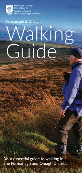
  • 1. Fermanagh & Omagh Walking Guide Your essential guide to walking in the Fermanagh and Omagh District
  • 2. Disclaimer Every care has been taken to ensure accuracy in the compilation of this guide. The information provided is, to the best of the promoter’s knowledge correct at the time of going to print. The promoters cannot accept responsibility for any errors or omissions but if they are brought to their notice, future publications will be amended accordingly. All maps are Crown Copyright and are reproduced with the permission of Land & Property Services under delegated authority from the Controller of Her Majesty's Stationery Office, © Crown Copyright and database right 2016 CS&LA156. More detailed maps can be sourced from www.walkni.com For specific queries regarding this publication or more general enquiries about access to the countryside and walking in the Fermanagh and Omagh District contact Fermanagh and Omagh District Council: Enniskillen: +0044 (0) 300 303 1777 Email: countryside@fermanaghomagh.com Plan ahead and prepare Maps in this guide are for illustrative purposes only. For those moderate and difficult walks it is advised that you obtain detailed maps before walking. Please ensure you are correctly equipped with suitable clothing and foot wear. Some of these walks are in truly natural surroundings, including steep ground, rocky scree, uneven surfaces and boggy sections – you are responsible for your own safety. www.fermanaghomagh.com Leave No Trace In order to minimise your social and environmental impacts on the outdoors, please follow the Seven Principles of Leave No Trace: 1. Plan Ahead and Prepare 2. Be Considerate of Others 3. Respect Farm Animals and Wildlife 4. Travel and Camp on Durable Ground 5. Leave What You Find 6. Dispose of Waste Properly 7. Minimise the Effects of Fire The walks have been graded into three categories: Easy Short walks generally fairly level going on well surfaced routes Moderate Longer walks with some gradients and generally on well surfaced routes Difficult Longer walks only suitable for more experienced walkers correctly equipped with waterproof clothing and strong walking boots Additional Information
  • 4. ❚ Nearest Town Carrickmore / Omagh ❚ Points of Interest Rich diversity of species, particularly on the raised bog ❚ Location An Creagán Centre is located on the main road between Omagh and Cookstown. ❚ Distance 0.25 miles / 3.4 miles ❚ Route Shape Circular ❚ Route Type Forest, riverside ❚ Facilities Café, shop, visitors centre and toilets are on site. Overview There are a number of trails on site taking in a variety of the habitats that makes An Creagán a haven for wildlife. You can choose from the Biodiversity trial, 0.25 miles, or if you want something a bit more challenging opt for the Forest and River Trail, 3.4 miles. Take a journey in the company of some of the most fascinating wildlife and stunning scenery. Trails are suitable for buggies and bikes. ❚ Contact: www.an-cregan.com An Creagán Trails Easy to Moderate Grade of Walk ©AnCreagán
  • 6. ❚ Nearest Town Enniskillen ❚ Points of Interest The dual court tomb at Aghanaglack - this ritual burial site dates from the Neolithic period between 4,000 and 2,000 years B.C. ❚ Location Access to the small car- park at Aghanaglack from Belcoo is five miles via the Aughrim Road and Gaedrum Road following signage to the chambered cairn ❚ Distance 7 miles ❚ Route Shape Circular ❚ Route Type Forest, woodland ❚ Facilities Car parking available, nearest amenities Belcoo Overview Aghanaglack Walk takes you through one of the largest continuous forestry tracts in Northern Ireland, mostly along forest tracks and with few gradients. This lengthy, yet comfortable walk offers impressive views across Lough MacNean to Cuilcagh Mountain. The most significant feature of this walk is the Aghanaglack Dual Court Tomb. (Part of the Marble Arch Caves Global Geopark) ❚ Contact: www.marblearchcavesgeopark.com Ballintempo Forest: Aghanaglack Walk Moderate Grade of Walk ©MACGG
  • 8. ❚ Nearest Town Bellanaleck ❚ Points of Interest Bellanaleck ASSI, range of Biodiversity ❚ Location The entrance to Waterhen Lane will be on your left handside, just after the 30 mph speed zone upon entering Bellanaleck from Enniskillen ❚ Distance 1.6 miles ❚ Route Shape Circular ❚ Route Type Lakeland, urban ❚ Facilities Public toilets are on the route. Play park for children. Bellanaleck village is a few 100meters away. Shop and tea rooms are available in town Overview The natural habitats of Bellanaleck are home to a rich array of native biodiversity which can be viewed along this walk; majestic oak trees, species rich grassland and open water to name a few. During the summer an impressive explosion of common- spotted orchids can be viewed along the road verge. This walk is also close to Bellanaleck ASSI, noted for its geological importance. ❚ Contact: www.fermanaghomagh.com Bellanaleck Loughshore Walk Easy Grade of Walk ©FODC
  • 10. Belmore Forest: Pollnagollum Cave Walk ❚ Nearest Town Enniskillen ❚ Points of Interest Pollnagollum Cave, waterfall ❚ Location Belmore Forest Car Park ❚ Distance 4.3 miles ❚ Route Shape Circular ❚ Route Type Forest, woodland ❚ Facilities Information panel and car parking available, nearest amenities Boho Overview The Pollnagollum/Coolarkan Cave Walk through Belmore Forest is at the heart of Fermanagh’s Boho cave country. The walking route is mostly along forest tracks and offers stunning landscapes and views of Belmore Mountain. The highlight of the walk is Pollnagollum Cave - meaning ‘hole of the doves’, which was recently used in filming the popular television series 'Game of Thrones'. A viewing platform at the caves provides a great vantage point to see the impressive cave entrance which is fed by a cascading waterfall toppling down a 12 metre limestone cliff to disappear into the depths of darkness. (Part of Marble Arch Caves Global Geopark) ❚ Contact: www.marblearchcavesgeopark.com Easy Grade of Walk ©MACGG
  • 12. Bessy Bell ❚ Nearest Town Omagh / Newtownstewart ❚ Points of Interest Holy well, wind farm ❚ Location Car park is situated at the Mellon Country Inn (A5 between Omagh and Newtownstewart) ❚ Distance 2.8 miles (one way) ❚ Route Shape Linear ❚ Route Type Road, gravel track and open grassland ❚ Facilities Facilities are available at the Mellon Country Inn or nearest towns in Omagh or Newtownstewart Overview Bessy Bell is a pleasant and interesting walk showcasing the beautiful and unique terrain of the Sperrins landscape. Starting at the Mellon Country Inn the track travels along the main road before turning uphill on a country lane. The linear track ascends the summit through a variety of tarmac, rough grassland and heather, where walkers will be rewarded with panoramic views of the surrounding area. ❚ Contact: www.fermanaghomagh.com Difficult Grade of Walk ©IMC
  • 13. Big Dog Forest: Big Dog Walk ©MACGG
  • 14. ❚ Nearest Town Derrygonnelly ❚ Points of Interest Possibly the most intriguing features along the walk are the two hills Big Dog and Little Dog ❚ Location The car park is adjacent to the Knockmore Road approximately eight miles from Derrygonnelly village, at the south side of the Doagh Road between Derrygonnelly and Garrison ❚ Distance 2.5 miles ❚ Route Shape Circular ❚ Route Type Forest, lakeland, woodland ❚ Facilities Car parking and picnic area available, nearest amenities Derrygonnelly Overview Big Dog Forest gets its name from the larger of the two small hills that dominate the skyline, known as Big Dog and Little Dog. Their names originate from Irish folklore as they are named after Bran and Skeola (Sceolan), two favourite Irish wolfhounds belonging to the legendary giant Finn McCool. One day while out hunting, the dogs picked up the scent of a witch and gave chase. To aid her escape the witch changed herself into a deer but the two dogs still gained ground on her, so in desperation she cast a spell turning them both into solid rock. (Part of the Marble Arch Caves Global Geopark). ❚ Contact: www.marblearchcavesgeopark.com Big Dog Forest: Big Dog Walk Easy Grade of Walk ©MACGG
  • 16. Carrigan Forest: Lough Formal Walk ❚ Nearest Town Derrygonnelly ❚ Points of Interest Lough Formal ❚ Location Coming from Enniskillen, approximately 10km from Derrygonnelly, take the lane on the right signed for Big Dog car park ❚ Distance 7 miles ❚ Route Shape Circular ❚ Route Type Forest, lakeland, woodland ❚ Facilities Information panel. Car parking available in car park for Big Dog Forest, nearest amenities Derrygonnelly Overview Carrigan Forest is situated approximately 12km outside the village of Derrygonnelly. It is the gateway between two significant expanses of upland forest, tucked between Big Dog Forest and Ballintempo Forest. Carrigan Forest showcases a landscape rich in limestone features. The Lough Formal walk is almost all on forestry tracks and features a short path through the heather to the summit of Formal More. (Part of the Marble Arch Caves Global Geopark). ❚ Contact: www.marblearchcavesgeopark.com Moderate Grade of Walk ©MACGG
  • 17. Castle Archdale Forest: Woodland Riverside Walk ©MACGG
  • 18. ❚ Nearest Town Kesh/Irvinestown ❚ Points of Interest The forest is a richly varied one in terms of views and features and includes ruined castles and ancient woodland ❚ Location Take the B82 from Enniskillen to Kesh, follow signposts to Castle Archdale Country Park ❚ Distance 0.5 miles ❚ Route Shape Circular ❚ Route Type Forest, riverside, woodland ❚ Facilities Picnic facilities and information panel. Additional facilities are located at the Countryside Centre within Castle Archdale Forest which include parking, information centre, toilets and restaurant Overview Castle Archdale Forest is a 520 hectare mixed broadleaved and coniferous lowland forest located on the eastern shores of Lower Lough Erne. The forest is a richly varied one in terms of views and features and includes ruined castles, WWII docks & buildings, ancient woodland and views over Lower Lough Erne to White Island, Davy's Island and further afield. (Part of the Marble Arch Caves Global Geopark). ❚ Contact: www.marblearchcavesgeopark.com Castle Archdale Forest: Woodland Riverside Walk Easy Grade of Walk ©MACGG
  • 19. Castle Archdale Forest: Tom’s Island Walk ©MACGG
  • 20. Castle Archdale Forest: Tom’s Island Walk ❚ Nearest Town Kesh/Irvinestown ❚ Points of Interest Lough Erne ❚ Location Take the B82 from Enniskillen to Kesh, follow signposts to Castle Archdale Country Park ❚ Distance 1.8 miles ❚ Route Shape Circular ❚ Route Type Forest, loughshore ❚ Facilities Picnic facilities and information panel. Additional facilities are located at the Countryside Centre within Castle Archdale Forest which include parking, information centre, toilets and restaurant Overview Tom’s Island trail in Castle Archdale is one of the finest spots to appreciate the stunning beauty of Lower Lough Erne. Start off by exploring the ruins of Old Castle Archdale, an impressive fortification built in 1612 when the Archdale family arrived in Ireland from Suffolk, England. The path then leads you along the river before the wide expanse of Lower Lough Erne opens up in front of you. You’ll then skirt the lough shore through dense woodland with incredible views of White Island and Davy’s Island. You will notice Tom’s Island is not actually an island however, before the lough was lowered many years ago it was cut off from the mainland by a shallow strip of water. (Part of the Marble Arch Caves Global Geopark). ❚ Contact: www.marblearchcavesgeopark.com Easy Grade of Walk ©MACGG
  • 22. ❚ Nearest Town Belleek ❚ Points of Interest Castle Caldwell ruins ❚ Location Turn off Kesh – Belleek A47 road about 8km from Belleek into Castle Caldwell Forest ❚ Distance 1.2 miles ❚ Route Shape Circular ❚ Route Type Forest ❚ Facilities Car parking and picnic facilities. Amenities available in Belleek village, approximately 5mile away. Overview The Beechwood Walk is part of the Marble Arch Caves Global Geopark and encompasses both lough shore and woodland paths. The walk takes in man-made and natural wonders, including a lime-kiln which hints at the association of the Caldwell estate with the nearby Belleek Pottery, a half-moon limestone bench along the shoreline and the eerie ruins of Castle Caldwell. (Part of the Marble Arch Caves Global Geopark). ❚ Contact: www.marblearchcavesgeopark.com Castle Caldwell Forest: Beechwood Walk Easy Grade of Walk ©IMC
  • 23. Castle Caldwell Forest: Castle Scenic Walk ©MACGG
  • 24. Castle Caldwell Forest: Castle Scenic Walk ❚ Nearest Town Belleek ❚ Points of Interest Castle Caldwell ruins ❚ Location Turn off Kesh – Belleek A47 road about 8km from Belleek into Castle Caldwell Forest ❚ Distance 0.3 miles ❚ Route Shape Circular ❚ Route Type Forest ❚ Facilities Car parking and picnic facilities. Amenities available in Belleek village, approximately 5mile away Overview The Castle Scenic Walk offers a gentle and appealing introduction to the Castle Caldwell estate. A series of forest tracks zig-zag through this ancient woodland area where views are dominated by the castle ruins. After passing through a section of walled garden, you will reach a gravel track leading to the foot of the ivy clad ruins of the old castle. Although the castle was eventually abandoned in the 1900’s, if local ghost stories are to be believed, the ruins are still haunted by Dennis McCabe, a fiddler who drowned after falling off the Caldwell family barge. A copy of the fiddler’s grave stone with its amusing inscription can be seen at the main entrance to the forest park. (Part of the Marble Arch Caves Global Geopark). ❚ Contact: www.marblearchcavesgeopark.com Easy Grade of Walk ©IMC
  • 26. Castle Caldwell Forest: Rossergole Point Walk ❚ Nearest Town Belleek ❚ Points of Interest Castle Caldwell ruins, Lime Kiln ❚ Location Turn off Kesh – Belleek A47 road about 8km from Belleek into Castle Caldwell Forest ❚ Distance 2.5 miles ❚ Route Shape Circular ❚ Route Type Forest, lakeland ❚ Facilities Car parking and picnic facilities. Amenities available in Belleek village, approximately 5mile away Overview This popular path takes in the remnants of the estate’s castle, forts, defence walls, jetties and lime kiln. Walkers who take time to explore the area will find the industrial- scale lime kiln highlighting the importance of the local limestone, once frequently fired in the kiln to produce quicklime, and taken by barge to the nearby town of Belleek. Another interesting feature which may be found at the eastern tip of the peninsula, are the walls of the old strategic defence fort of Rossergole Point. This fortification no doubt played a vital role in protecting and controlling trade along this route. Today the old ruins offer walkers a vantage point for breathtaking views over Lower Lough Erne. (Part of the Marble Arch Caves Global Geopark). ❚ Contact: www.marblearchcavesgeopark.com Easy Grade of Walk ©MACGG
  • 27. Castle Coole: Beech Walk ©CarolineJohnston
  • 28. Castle Coole: Beech Walk ❚ Nearest Town Enniskillen ❚ Points of Interest Ice House, Castle Coole House ❚ Location Castle Coole is located off the A4 road to Belfast 1.5 miles South East of Enniskillen. Parking is located beside the reception and tea room area ❚ Distance 0.5 miles ❚ Route Shape Circular ❚ Route Type Woodland ❚ Facilities Car park, picnic area, Tallow House Tea-room, shop and toilets (disabled access) and children’s play area Overview The Beech wood forms a backdrop to the Neoclassical mansion and contains a tranquil walk through unspoilt nature. The wood was planted around 1709 with a mixed group of beech, oak and scots pine. The wood still has oak trees dating back to the early 18th century and contains the oldest trees in the park. Visit in spring to see a carpet of bluebells amongst the trees, and make sure to visit the 18th century Ice House. For a longer walk, take the adjoining Gortgonnell path. *National Trust entrance pricing applies for this walk* ❚ Contact: www.nationaltrust.org.uk/castle-coole Easy Grade of Walk ©CarolineJohnston
  • 29. Castle Coole: Lake Walk ©NationalTrust
  • 30. ❚ Nearest Town Enniskillen ❚ Points of Interest Castle Coole House, Boathouse ❚ Location Castle Coole is located off the A4 road to Belfast 1.5 miles South East of Enniskillen. Parking is located beside the reception and tea room area ❚ Distance Just over 1 mile long ❚ Route Shape Circular ❚ Route Type Woodland, lakeland ❚ Facilities Car park, picnic area, Tallow House Tea-room, shop and toilets (disabled access) and children’s play area Overview The Lake Walk forms part of the original historic track around the lake, which was created by the 1st Earl of Belmore in the late 18th century. It provides a number of beautiful vistas across the lake - keep an eye out for the resident swans! This part of the estate is a protected conservation site, so please keep dogs on leads where signage suggests. Make a detour to the lake edge to take in views of the house and surrounding countryside. *National Trust entrance pricing applies for this walk* ❚ Contact: www.nationaltrust.org.uk/castle-coole Castle Coole: Lake Walk Easy Grade of Walk ©CarolineJohnston
  • 32. Correl Glen ❚ Nearest Town Derrygonnelly ❚ Points of Interest Large silverwashed fritillary, Lough views ❚ Location Follow signs for Lough Navar Forest Drive signposted from A46 and B82 ❚ Distance 1 mile ❚ Route Shape Circular ❚ Route Type Woodland ❚ Facilities Car park, interpretation. Nearest amenities in Derrygonnelly Overview The Correl Glen is a designated nature reserve containing a delightful nature trail just across the road from the entrance to Lough Navar Forest. The glen is dominated by native woodland where a combination of birch, oak, ash and holly trees cloak a ravine that has been carved by the fast flowing Sillees River, which is home to freshwater crayfish. A variety of species of butterfly and damselfly, most notably the silver-washed fritillary, the largest butterfly on the island of Ireland, can be seen here during the spring and summer months. ❚ Contact: www.daera-ni.gov.uk/northern-ireland- environment-agency Easy Grade of Walk ©TimFlaherty
  • 34. Crocknagrally Forest ❚ Nearest Town Fivemiletown ❚ Points of Interest Colebrooke River ❚ Location The start of the walk is at the entrance to Crocknagrally Forest - located on the Mullaghfad Road approximately one mile from the Mullaghfad/ Alderwood Road junction ❚ Distance 4.2 miles ❚ Route Shape Circular ❚ Route Type Forest ❚ Facilities Carparking on site. Nearest amenities in Fivemiletown (approximately 5 mile) Overview This circular walk is all on hard surface forest tracks through Crocknagrally Forest. Crocknagrally is an upland predominantly coniferous forest that lies between Brookeborough and Fivemiletown. This 630 hectare forest forms part of a larger connected mass of forests that includes Doon, Jenkin, Knocks, Tully, Mullaghfad, Carnmore, Grogey and Fardross Forests which cover 8,000 hectares spilling down from the Slieve Beagh plateau. This walk was developed as part of the Clones Erne East Blackwater (CEEB) Rural Regeneration project. ❚ Contact: www.fermanaghomagh.com Moderate Grade of Walk ©IMC
  • 36. Crom ❚ Nearest Town Newtownbutler ❚ Points of Interest Crom Old Castle, boat house, summer house, ancient Crom yew trees ❚ Location On Newtownbutler to Crom road, or follow signs from Lisnaskea (7 miles). Crom is next to the Shannon to Erne waterway ❚ Distance 4.2 miles ❚ Route Shape Circular ❚ Route Type Woodland, parkland, lakeside ❚ Facilities Picnic area, car park, toilets, family activity packs and childrens play area Overview Crom is one of Ireland’s most important conservation sites and possesses the largest area of oak woodland in Northern Ireland. Try spotting a range of wildlife including deer, bats, wading birds, pine martens, red squirrels and a thriving otter population. A figure-of- eight takes you from the shores of Upper Lough Erne past the Old Castle Ruins and on a loop around Inisherk Island. Return via the deer park along the edge of Lough Nalughoge. Appropriate footwear is necessary as parts of the route can be on soft ground. *National Trust entrance pricing applies for this walk* ❚ Contact: www.nationaltrust.org.uk/crom Easy Grade of Walk ©CarolineJohnston
  • 37. Cuilcagh Way: Walk 1 Cladagh Glen Walk ©MACGG
  • 38. ❚ Nearest Town Enniskillen / Belcoo ❚ Points of Interest Caves, the Folly, the Cascade ❚ Location The Cladagh Glen car park is signposted on the Blacklion to Florencecourt Road ❚ Distance 1.5 miles ❚ Route Shape Linear ❚ Route Type Riverside, woodland ❚ Facilities Car park. The Visitor Centre at the Marble Arch is open from late March to September, from 10.00 am-4.30/5.00 pm, with toilets, café, shop Overview The Cladagh Glen Walk is a way marked linear route through the striking landscape of the Cladagh River gorge. Following the course of the river, this walking route takes you through a steep limestone gorge that is thickly covered by an ancient ash woodland. Though it was once widespread, this sort of damp ash woodland is now rare in Ireland and the entire gorge is protected as part of the Marble Arch National Nature Reserve. There are many features of interest along the route - steep limestone cliffs, cascading waterfalls, cave springs, a turbulent river and a rich treasury of wild flowers. The most important feature to visit is the Marble Arch, an impressive natural archway that spans over the river, it is here that the Marble Arch Caves take its name. (Part of the Marble Arch Caves Global Geopark). ❚ Contact: www.marblearchcavesgeopark.com Cuilcagh Way: Walk 1 Cladagh Glen Walk Moderate Grade of Walk ©MACGG
  • 39. Cuilcagh Way: Walk 2 Cuilcagh Legnabrocky Trail ©CarolineJohnston
  • 40. Cuilcagh Way: Walk 2 Cuilcagh Legnabrocky Trail ❚ Nearest Town Belcoo ❚ Points of Interest Cuilcagh Mountain, Cuilcagh Boardwalk ❚ Location Follow the signs for the Marble Arch Caves Visitor Centre from Enniskillen. After the Marble Arch Caves there will be a sign on your left handside for the Cuilcagh Mountain Park ❚ Distance 4.5 miles ❚ Route Shape Linear ❚ Route Type Mountain ❚ Facilities Car park. The Visitor Centre at the Marble Arch is open from late March to September, from 10.00 am-4.30/5.00 pm, with toilets, café, shop Overview The Cuilcagh Legnabrocky Trail is a linear route which will appeal to walkers with some experience walking in the hills. The route is quite isolated and showcases the scenic wilderness of Cuilcagh Mountain. The trail meanders along a quiet farmland track before traversing a wooden boardwalk that consists of a steady climb to the mountain face. Here a stepped boardwalk climbs through steep terrain and boulders fields before reaching the summit plateau. A rough mountain path negotiates the wild summit plateau for a few kilometres before reaching an ancient cairn (the remains of a burial mound dating from the Bronze Age 2,500 – 500 BC) that stands at 666 metres above sea level. (Part of the Marble Arch Caves Global Geopark). ❚ Contact: www.marblearchcavesgeopark.com Difficult Grade of Walk ©GarethMcFarland
  • 41. Cuilcagh Way: Walk 3 Cuilcagh Hiker’s Trail ©MACGG
  • 42. Cuilcagh Way: Walk 3 Cuilcagh Hiker’s Trail ❚ Nearest Town Swanlinbar ❚ Points of Interest Summit of Cuilcagh Mountain ❚ Location Follow the A32 out of Enniskillen; Start point at Gortalaughney Viewpoint is signposted from the road ❚ Distance 5.5 miles ❚ Route Shape Linear ❚ Route Type Mountain ❚ Facilities Facilities are available at the nearby Marble Arch Caves Visitor Centre and Florencecourt House Overview The Cuilcagh Hiker’s Trail is a way marked linear route that will appeal to experienced walkers who enjoy spectacular views and are interested in undertaking a vigorous, challenging walk in the wilderness. The terrain consists of a mountain path so some parts of the route can be very wet and boggy, particularly after a rainy period. Due to the often challenging weather conditions on Cuilcagh Mountain, careful planning, constant vigilance and good navigation are required all year round. The trail is a richly varied one in terms of topography and features, and includes walking over a glacial landscape in a mountainous environment passing by dry valleys, limestone pavement, mountain rivers and sandstone outcrops. This area is also managed by the Royal Society for the Protection of Birds so keep alert for signs of the rare golden plover nesting in the area. (Part of the Marble Arch Caves Global Geopark). ❚ Contact: www.marblearchcavesgeopark.com Difficult Grade of Walk ©CarolineJohnston
  • 43. Cuilcagh Way: Walk 4 Legacurragh Valley Trail ©MACGG
  • 44. Cuilcagh Way: Walk 4 Legacurragh Valley Trail ❚ Nearest Town Enniskillen ❚ Points of Interest Legacurragh Dry Valley, Florence Court House, Benaughlin Mountain ❚ Location Follow the A32 out of Enniskillen; Start point at Gortalaughney View point is signposted from the road ❚ Distance 4.2 miles ❚ Route Shape Linear ❚ Route Type Forest, mountain ❚ Facilities Tea rooms, shop, picnic area, playground, and toilets all available in nearby Florence Court House Overview The Legacurragh Valley Trail is a way marked linear route through some of Fermanagh’s finest scenery, showcasing its wilderness, mountains, valleys, forests and rivers. The terrain consists of a blanket bog path, forestry tracks and tarmac lane, very much away from the hustle and bustle of roads. The route has a wealth of interest in terms of landscapes and heritage, and involves walking through open moorland which is buzzing with nature as well as long stretches along shady woodland paths to discover tranquil rivers, a diversity of flowers and rustic farm ruins. (Part of the Marble Arch Caves Global Geopark). ❚ Contact: www.marblearchcavesgeopark.com Difficult Grade of Walk ©CharlesJohnston
  • 45. Cuilcagh Way: Walk 5 Florence Court Forest Trail ©CarolineJohnston
  • 46. ❚ Nearest Town Enniskillen ❚ Points of Interest Florence Court House, Gortmaconnell Rock ❚ Location Follow the A32 from Enniskillen. Florence Court is fully signposted from the road ❚ Distance 4.5 miles ❚ Route Shape Linear ❚ Route Type Forest, woodland ❚ Facilities Tea rooms, shop, picnic area, playground, and toilets all available in nearby Florence Court House Overview When starting your walk from the carpark follow the Florence Court waymarked red trail, for the next few kilometres it takes you along narrow tracks which twist and turn an undulating course past mixed deciduous woodland crossing the Larganess River in several places. As you reach the edge of the forest you will pick up the trail sign for the Cuilcagh Way (Florence Court Forest Trail). It weaves its way through forests alive with a wide variety of wildlife, birds and plants before sauntering around the foothills of the Marlbank karst region. Added to these surroundings are corridors of lofty trees, dynamic rivers, rambling stone field walls, a rich treasury of wild flowers and a unique density of rustic farmsteads. (Part of the Marble Arch Caves Global Geopark). *Note: Start is within the National Trust car park, entrance pricing applies* ❚ Contact: www.marblearchcavesgeopark.com Cuilcagh Way: Walk 5 Florence Court Forest Trail Moderate Grade of Walk ©CarolineJohnston
  • 47. Ely Lodge Forest: Carrickreagh Jetty Walk ©MACGG
  • 48. Ely Lodge Forest: Carrickreagh Jetty Walk ❚ Nearest Town Enniskillen ❚ Points of Interest Lower Lough Erne ❚ Location From Enniskillen, travel north along the A46 Shore road towards Belleek. Approximately 10km from Enniskillen, Ely Lodge Forest car park is signed and located on the right ❚ Distance 1.3 miles ❚ Route Shape Linear ❚ Route Type Lakeland, woodland ❚ Facilities Car park and picnic tables. Nearest amenities in Enniskillen Overview The Carrickreagh Jetty Walk is a blue waymarked linear route through a woodland landscape skirting the shoreline of Lower Lough Erne. The path meanders through the forest which is alive with green foliage and the undergrowth glows a vibrant green with moss, wood sorrel and ferns carpeting the ground beneath the trees. Added to these surroundings are areas where the forest opens to provide glimpses of Lower Lough Erne and its surroundings. Take a moment to look at the Crannog, Inish Lougher and Inish Fovar Islands, which are directly opposite the shoreline. These islands and the surrounding shore, are an important area for a variety of wild fowl and water birds. You can proceed to the jetty and take the opportunity to enjoy the panoramic views from the lake. (Part of the Marble Arch Caves Global Geopark). ❚ Contact: www.marblearchcavesgeopark.com Easy Grade of Walk ©CarolineJohnston
  • 49. Ely Lodge Forest: Carrickreagh Viewpoint Walk ©FODC
  • 50. Ely Lodge Forest: Carrickreagh Viewpoint Walk ❚ Nearest Town Enniskillen ❚ Points of Interest Outlook from Carrickreagh Jetty ❚ Location From Enniskillen, travel north along the A46 Shore road towards Belleek. Approximately 10km from Enniskillen, Ely Lodge Forest car park is signed and located on the right ❚ Distance 1.5 miles ❚ Route Shape Circular ❚ Route Type Forest, woodland ❚ Facilities Car park and picnic tables. Nearest amenities in Enniskillen Overview Ely Lodge Forest was once part of the demesne of the Marquis of Ely, Nicholas Loftus. The lodge was one of two gatehouses to the Ely Estate, which was the largest in County Fermanagh during Victorian times. This walking route is mostly along forest tracks and offers stunning landscapes and views of Lower Lough Erne. The outlook from the viewpoint within Ely Lodge Forest is spectacular with views over the Bluestack Mountains of County Donegal to the North and Sligo Bay and the Atlantic Ocean to the West. (Part of the Marble Arch Caves Global Geopark). ❚ Contact: www.marblearchcavesgeopark.com Easy Grade of Walk ©CarolineJohnston
  • 51. Ely Lodge Forest: Loughshore Walk ©CarolineJohnston
  • 52. Ely Lodge Forest: Loughshore Walk ❚ Nearest Town Enniskillen ❚ Points of Interest Red squirrels ❚ Location From Enniskillen, travel north along the A46 Shore road towards Belleek. Approximately 10km from Enniskillen, Ely Lodge Forest car park is signed and located on the right ❚ Distance 1.3 miles ❚ Route Shape Circular ❚ Route Type Forest ❚ Facilities Car park and picnic tables. Nearest amenities in Enniskillen Overview The Loughshore Walk takes you through 250 hectares of woodland containing a delightful mixture of coniferous and broadleaved trees. The conifers are mainly European larch, which is uncommon as they lose their needles in autumn. The broadleaves are dominated by ash and beech and the understory of the forest includes natives such as hazel, holly, spindle and guilder rose. (Part of the Marble Arch Caves Global Geopark). ❚ Contact: www.marblearchcavesgeopark.com Easy Grade of Walk ©MACGG
  • 53. Florence Court Forest Park: Blue Trail ©CarolineJohnston
  • 54. ❚ Nearest Town Enniskillen ❚ Points of Interest Florence Court Yew, House, Walled Garden, Sawmill, Ice House ❚ Location Signposted from the A4 - Enniskillen to Sligo Road ❚ Distance 2.2 miles ❚ Route Shape Circular ❚ Route Type Woodland ❚ Facilities Car park, picnic areas, toilets (disabled access), Stables Tea-room, Visitor Centre, Coach House shop, baby changing facilities, children's play area, guided tours of the house available Overview There is something for all the family at this warm and welcoming 18th century estate, the former home of the Earls of Enniskillen. Florence Court enjoys a peaceful setting in west Fermanagh against a dramatic backdrop of mountains and forests. The Blue Trail offers an even gradient walk through the Pleasure Grounds and native Irish woodland with historical estate features along the way, including the Florence Court yew tree and water- powered sawmill. *National Trust entrance pricing applies for this walk* ❚ Contact: www.nationaltrust.org.uk/florence-court Florence Court Forest Park: Blue Trail Easy Grade of Walk ©CarolineJohnston
  • 55. Florence Court Forest Park: Red Trail ©MACGG
  • 56. Florence Court Forest Park: Red Trail ❚ Nearest Town Enniskillen ❚ Points of Interest Formal walled gardens, Lady's well, Florence Court House, Mother Yew, views across Fermanagh, historic Deer Park ❚ Location Signposted from the A4 - Enniskillen to Sligo Road ❚ Distance 5.6 miles ❚ Route Shape Circular ❚ Route Type Parkland & grassland, riverside, woodland ❚ Facilities Car park, picnic areas, toilets (disabled access), Stables Tea-room, Visitor Centre, Coach House shop, baby changing facilities, children's play area, guided tours of the house available Overview The Florence Court Red Trail follows the Claddagh River upstream into the forest park, winding through the forest park with occasional steep climbs and rewarding walkers with views across Fermanagh at its peak. On a clear day you should be able to see across much of Fermanagh, including Upper Lough MacNean, Belmore Mountain, Enniskillen, Brougher Mountain, parts of Upper Lough Erne and Knockninny, amongst others. There is the option to continue your walk onto the Cuilcagh Way and Ulster Way should you so wish. *National Trust entrance pricing applies for this walk* ❚ Contact: www.nationaltrust.org.uk/florence-court Moderate Grade of Walk ©MACGG
  • 58. Gortin Forest: Ladies View Trail ❚ Nearest Town Gortin / Omagh ❚ Points of Interest Outstanding views, waterfall ❚ Location Entrance located and signposted from the Gortin Road, approximately 6 miles from Omagh. ❚ Distance 2.25 miles ❚ Route Shape Circular ❚ Route Type Forest, hill ❚ Facilities Parking, picnic tables and toilets onsite. Nearest amenities Omagh or Gortin Overview This a strenuous walk following the red trail from the Gortin Glens car park up to the summit of Mullaghcarn. Walkers will be rewarded with magnificent views over the surrounding countryside at the top. A quaint waterfall and the accompanying soundtrack of the quick flowing Pollan Burn running alongside the trail, make this an enjoyable walk that is worth the effort. *Forest Service NI charge may apply.* ❚ Contact: www.daera-ni.gov.uk/topics/forestry Difficult Grade of Walk ©IMC
  • 59. Gortin Forest: Nature Trail ©IMC
  • 60. Gortin Forest: Nature Trail ❚ Nearest Town Gortin / Omagh ❚ Points of Interest Red squirrels, countryside views ❚ Location Entrance located and signposted from the Gortin Road, approximately 6 miles from Omagh ❚ Distance 1.25 miles ❚ Route Shape Circular ❚ Route Type Forest, hill ❚ Facilities Parking, picnic tables and toilets onsite. Nearest amenities Omagh or Gortin Overview This short trail offers walkers the chance to sample the vast array of habitats that the Gortin Glens Forest has to offer. A short stroll past the stream, linking through a small section of forest leads out to a wide expanse of open bog with excellent sweeping views of the surrounding landscape. On the way back down through the forest, quiet and observant visitors may be lucky enough to catch sight of the elusive red squirrels that are resident within the trees. *Forest Service NI charge may apply.* ❚ Contact: www.daera-ni.gov.uk/topics/forestry Easy Grade of Walk ©IMC
  • 61. Gortin Forest: Pollan Walk ©IMC
  • 62. ❚ Nearest Town Gortin / Omagh ❚ Points of Interest Rich diversity of flora and fauna, waterfall ❚ Location Entrance located and signposted from the Gortin Road, approximately 6 miles from Omagh ❚ Distance 1.25 miles ❚ Route Shape Circular ❚ Route Type Forest, riverside ❚ Facilities Parking, picnic tables and toilets onsite. Nearest amenities Omagh or Gortin Overview This walk follows the same start as the Ladies View Trail but it offers a shorter alternative. There is a steep incline that follows the Pollan Burn as it weaves and cuts its way though the hillside. A charming waterfall offers walkers a welcome rest to appreciate the natural beauty of the glens. *Forest Service NI charge may apply.* ❚ Contact: www.daera-ni.gov.uk/topics/forestry Gortin Forest: Pollan Walk to Moderate Grade of Walk Easy ©IMC
  • 64. Gortin Lakes ❚ Nearest Town Gortin ❚ Points of Interest Lakes, panoramic views ❚ Location The car park is signposted and located 0.5 miles off the main A48 Omagh to Gortin Road. ❚ Distance 0.6 miles ❚ Route Shape Circular ❚ Route Type Lakeside ❚ Facilities Toilets, parking, picnic tables. Nearest amenities Omagh or Gortin Overview The Gortin Lakes walk is a hidden gem; the lakes, known as kettle-holes, were formed from melted blocks of ice abandoned by the retreating ice sheet from the last ice age. The varied array of birdlife makes for wonderful company walking around the short, figure-of-eight path. The lakes are located within Murrin Nature Reserve that is managed by NIEA. ❚ Contact: www.fermanaghomagh.com Easy Grade of Walk ©FODC
  • 66. Gortmaconnell Viewpoint Walk ❚ Nearest Town Blacklion ❚ Points of Interest Gortmaconnell Rock, stunning views of Cuilcagh Mountain and the Marlbank area ❚ Location The start of the walk is located on the Florencecourt to Blacklion Road, 750m before the entrance to the Marble Arch Caves ❚ Distance 1.2 miles ❚ Route Shape Linear ❚ Route Type Mountain ❚ Facilities Car park - Please keep one gate free of cars as this is a working farm Overview The summit of Gortmaconnell Rock can be reached by a short but rewarding climb contouring around the hill. Walkers will be rewarded with wonderful 360 degree panoramic views of Cuilcagh Mountain, MacNean Valley and the Erne Lowlands. The Owenbrean River can be seen here also, flowing down from Cuilcagh Mountain before sinking underground, eventually reaching the Marble Arch Caves system. (Part of the Marble Arch Caves Global Geopark). ❚ Contact: www.marblearchcavesgeopark.com Moderate Grade of Walk ©SimonGray
  • 67. Jenkin Forest and Lakes ©FODC
  • 68. Jenkin Forest and Lakes ❚ Nearest Town Fivemiletown ❚ Points of Interest Breeding Hen Harriers, Lough Jenkin ❚ Location The start of the walk is at the entrance to Crocknagrally Forest - located on the Mullaghfad Road. When in Fivemiletown take the left turn sign posted Cooneen. Continue out this road until you cross a stone bridge, there will be a sign to the left saying Mullaghfad and Jenkin Lakes. After about 3km there is a forest road entrance on the left - this car park is for Crocknagrally Forest, but the Jenkin Lough Forest walk can be accessed from here. ❚ Distance 7.4 miles ❚ Route Shape Circular ❚ Route Type Forest, lakeside ❚ Facilities Small car park at entrance to the walk on the Jenkin Road, off the Mullaghfad Road and approximately one mile from Cooneen Church Overview This walk is mostly on forest roads giving walkers the opportunity to enjoy the peace and tranquillity of east Fermanagh. There is a small section of board walk which transverses a section of blanket bog, leading down in to glorious views of Jenkin Lough. It is worth going the extra distance to encompass Lough Nadarra and Lough Cushkerry, hidden among the plantation forests. This walk was developed as part of the Clones Erne East Blackwater (CEEB) Rural Regeneration Project. ❚ Contact: www.fermanaghomagh.com Moderate Grade of Walk ©FODC
  • 70. ❚ Nearest Town Rosslea ❚ Points of Interest The Lough and countryside surroundings ❚ Location The main entrance is off the B36 road between Lisnaskea and Rosslea ❚ Distance 1.5 miles ❚ Route Shape Circular ❚ Route Type Lakeside ❚ Facilities Car parking - There are two places to park - one at the old waterworks site where there is more space here or on the Lisnaskea- Rosslea road. There are also fishing stands suitable for wheelchair users. There is a picnic table at the road side car park. Overview Where the townlands of Aghadrumsee, Killylackey, Killyfole and Loughgare meet there is a body of water known as a Lough. It is called 'Killyfole Lough', but is often called the 'Mill Lough' by locals, due to there being an old corn mill nearby. This 1.5 mile walkway around Killyfole Lough has been developed by Killyfole Development Association to an excellent standard. Almost 1km of the path is suitable for wheelchairs. ❚ Contact: www.fermanaghomagh.com Killyfole Lough Grade of Walk Easy ©CarolineJohnston
  • 71. Lough Navar Forest: Blackslee Waterfall Walk ©MACGG
  • 72. ❚ Nearest Town Derrygonnelly / Enniskillen ❚ Points of Interest Viewpoint, waterfall, willow sculptures ❚ Location From Enniskillen take the A46 to Derrygonnelly and then follow the signs for the 'Forest Drive' ❚ Distance 4 miles ❚ Route Shape Circular ❚ Route Type Forest ❚ Facilities Car parking & picnic tables throughout the forest. Nearest amenities in Derrygonnelly. Overview Aghameelan Viewpoint car park is the starting point for the waymarked Blackslee Trail. This 4 mile walk along forest roads makes its way through the oldest part of the forest and leads to a waterfall at its furthest point. (Part of the Marble Arch Caves Global Geopark). ❚ Contact: www.marblearchcavesgeopark.com Moderate Grade of Walk Lough Navar Forest: Blackslee Waterfall Walk ©IMC
  • 73. Lough Navar Forest: Lough Navar Achork Walk ©MACGG
  • 74. ❚ Nearest Town Derrygonnelly / Enniskillen ❚ Points of Interest Lough Achork ❚ Location From Enniskillen take the A46 to Derrygonnelly and then follow the signs for the 'Forest Drive' ❚ Distance 1.8 miles ❚ Route Shape Circular ❚ Route Type Forest, lakeland ❚ Facilities Car parking & picnic tables throughout the forest. Nearest amenities in Derrygonnelly. Overview A path has been provided which circles this pleasant lake and offers views across the lake and its surrounding rugged hills. The sheltered location of the lake and fringing woodland with its abundance of food make the area a popular haven for birds, otters, ducks, swans, foxes, deer, hares which can often be spotted feeding, nesting or rearing their young in the area all year round. (Part of the Marble Arch Caves Global Geopark). ❚ Contact: www.marblearchcavesgeopark.com Moderate Grade of Walk Lough Navar Forest: Lough Navar Achork Walk ©IMC
  • 75. Lough Navar Forest: Lough Navar Lakes Walk ©IMC
  • 76. ❚ Nearest Town Derrygonnelly / Enniskillen ❚ Points of Interest Views, lakes and stunning landscape ❚ Location From Enniskillen take the A46 to Derrygonnelly and then follow the signs for the 'Forest Drive'. ❚ Distance 7 miles ❚ Route Shape Circular ❚ Route Type Forest, woodland ❚ Facilities Car parking & picnic tables throughout the forest. Nearest amenities in Derrygonnelly. Overview The Lough Navar Lakes walk, which encapsulates all four lakes, starts from Meenameen Lough. This walk skirts the western shore line of Lough Meenameen before disappearing deep into the heart of the forest and passing by Lough Navar and Lough Naman before branching off to loop the shore line of Lough Achork. (Part of the Marble Arch Caves Global Geopark). ❚ Contact: www.marblearchcavesgeopark.com Moderate Grade of Walk Lough Navar Forest: Lough Navar Lakes Walk ©HannahNorthridge
  • 77. Lough Navar Forest: Magho Cliffs Walk ©MACGG
  • 78. ❚ Nearest Town Derrygonnelly / Enniskillen ❚ Points of Interest The 300 metre high Magho cliffs ❚ Location From Enniskillen take the A46 to Derrygonnelly and then follow the signs for the 'Forest Drive' ❚ Distance 1.3 miles ❚ Route Shape Linear ❚ Route Type Forest, lakeland ❚ Facilities Car parking & picnic tables throughout the forest. Nearest amenities in Derrygonnelly. Overview The initial part of the walk takes you across the top of the Magho Cliffs offering great panoramic views of the surrounding area. At the end of this path take a moment to rest on the bench provided and soak in the tranquil atmosphere. The cliffs are an Area of Special Scientific Interest as they support an exceptional range of habitats. The abundance of wildlife is very evident, keep an eye out for the array of butterflies and birds feeding in the area. To continue the walk return back along the cliff top path and follow the black route way markers which will bring you down the cliff twisting and winding its way through the woodland with patches of open area providing great glimpses of the cliff escarpment. (Part of the Marble Arch Caves Global Geopark). ❚ Contact: www.marblearchcavesgeopark.com Lough Navar Forest: Magho Cliffs Walk Grade of Walk Difficult ©IMC
  • 80. Loughmacrory ❚ Nearest Town Loughmacrory village / Omagh ❚ Points of Interest Natural freshwater lough ❚ Location From Loughmacrory village, take the Ballybrack Road. Two large stone pillars signal the entrance to the walk ❚ Distance 1.3 miles ❚ Route Shape Circular ❚ Route Type Lakeside, forest ❚ Facilities Picnic benches. Toilets at the community centre. Closest amenities in Loughmacrory village or Omagh. Overview Loughmacrory is based in beautiful rural surroundings, providing locals and visitors alike with a loughshore path to enjoy the unspoilt environment around this freshwater lake. Visitors may be lucky enough to catch sight of the electric blue kingfishers, or some of the wild duck that have chosen the lough as their nesting grounds. ❚ Contact: www.loughmacrory.com Easy Grade of Walk ©IMC
  • 82. Marlbank (Killykeegan) ❚ Nearest Town Belcoo ❚ Points of Interest Limestone landscapes, hazel glades ❚ Location Follow signs for Marlbank Scenic loop and Marble Arch Caves/Cuilcagh Geopark. The carpark is situated approximately 1 mile from the Marble Arch Caves entrance. ❚ Distance 0.5 miles ❚ Route Shape Circular ❚ Route Type Parkland, grassland, woodland ❚ Facilities Car park and toilets are open 11.00am-6.00 pm between Easter and September (closed September-Easter). McGrath's cottage holds a small interpretive display on local history (open daily July & August and weekends in May, June & Sept). Overview This nature reserve's limestone grassland is managed through conservation grazing and is characterized by low growing plants such as thyme and bird's foot trefoil. Bird's foot trefoil is the food plant of the caterpillars of the rare dingy skipper butterfly, which can be found here in early summer together with the common blue and another rarity, the marsh fritillary butterfly. In places the limestone is overlain by patches of more acidic soils which, in early June are swathed with pink heath-spotted orchids. Scattered lesser butterfly orchids also occur here, their flowers mimicking white moths which are thus lured to pollinate them. Rarities found here include field gentian and the small white mountain orchid. Hazel scrub has found a niche within the nature reserve as well. Here you might be lucky enough to catch a glimpse of a red squirrel, pine martens or Irish stoat. Cuckoos can be heard calling as they seek out meadow pipits' nests in which to lay their egg. ❚ Contact: www.daera-ni.gov.uk Easy Grade of Walk ©CarolineJohnston
  • 84. Robbers Table ❚ Nearest Town Omagh / Gortin ❚ Points of Interest Panoramic views, distinctive rural landscape ❚ Location Park at the Gortin Glens forest (signposted off the main road between Omagh and Gortin). Start the walk on the Lisnaharney Road ❚ Distance 8.1 miles ❚ Route Shape Circular ❚ Route Type Hill, open farmland ❚ Facilities Car parking, picnic tables and toilets on site at Gortin Glens. Nearest amenities in Omagh or Gortin Overview This off road hill walk is set among a rural landscape, marked with bellowing hedges and stone walls, dividing the surrounding fields. The ruins of Castleroddy National School and the derelict farm sheds, with their distinctive orange tin roofs are marks on the landscape of times gone-by. On clear days, the Donegal and high Sperrin Mountains can be seen in all their glory. This is an enjoyable and satisfying walk for those who are keen for a longer, off road route. ❚ Contact: www.fermanaghomagh.com Moderate Grade of Walk ©IMC
  • 86. ❚ Nearest Town Seskinore ❚ Points of Interest Copper beech, historic buildings, biodiversity ❚ Location Car park is located on the main Omagh to Seskinore Road. ❚ Distance No specified routes within forest but all paths are suitable for walking ❚ Route Shape Circular ❚ Route Type Gravel paths, woodland ❚ Facilities Car park Overview Seskinore Forest is 135 hectares of a mixed coniferous and broadleaved woodland. There are no way marked routes through the forest but there are looped paths throughout. The forest once belonged to the McClintock Estate and remnants of the old farm buildings are still onsite. The area is rich in biodiversity, with each season bringing change within the forest. Look out for the magnificent copper beach located in the open area of the old courtyard. ❚ Contact: www.nidirect.gov.uk/articles/seskinore-forest Seskinore Forest Grade of Walk Easy ©IMC
  • 88. Sloughan Glen ❚ Nearest Town Drumquin ❚ Points of Interest Waterfall ❚ Location Sloughan Glen is sign posted from B50 (Omagh to Castlederg Road) or B84 (Drumquin to Dromore Road) ❚ Distance 0.3 miles ❚ Route Shape Linear ❚ Route Type Gravel path ❚ Facilities Car park and picnic facilities on site Overview Sloughan Glen is a short walk set within the glen that leads to a splendid waterfall. From the car park, follow the path up to the waterfall. Steep steps ascend to a path that walks on the high side overlooking the waterfall. This walk is a peaceful retreat away from the hustle and bustle of the urban life. ❚ Contact: www.fermanaghomagh.com Easy Grade of Walk ©IMC
  • 90. Topped Mountain ❚ Nearest Town Lisbellaw ❚ Points of Interest ‘Trig’ Point, cairn, panoramic views ❚ Location Topped Mountain is signposted from main Enniskillen to Tempo Road. Gravel Car Park is on sharp bend beside small lough. ❚ Distance 0.6 mile return ❚ Route Shape Linear ❚ Route Type Gravel track and open grassland ❚ Facilities Car Park. Nearest facilities in nearby Lisbellaw. Overview Topped Mountain, standing at only 277metres is technically a hill, however, a short, sharp climb from the car park leads to the summit which provides extensive 360 degree vistas over Upper and Lower Lough Erne and the west of the province. On a clear day the Sperrins can be seen to the north, Clogher Valley to the east and all of Fermanagh lies before you to the west. On the summit you will find a 'trig' point and an ancient cairn. The ancient cairn is a protected monument while the trig point was originally erected by Ordnance Survey to assist with the remapping of Britain. ❚ Contact: www.fermanaghomagh.com Moderate Grade of Walk ©IMC
  • 92. Tully Castle ❚ Nearest Town Derrygonnelly ❚ Points of Interest Plantation castle Tully Castle built in 1613 ❚ Location From Enniskillen, travel north along the A46 Shore road towards Belleek. Approximately 15km from Enniskillen, Tully Castle is signed and located on the right ❚ Distance 1.2 miles ❚ Route Shape Circular ❚ Route Type Lakeland, parkland & grassland, riverside ❚ Facilities Toilets and picnic benches are available on site Overview This charming walk takes in the castle grounds with commanding views of the castle ruins and the surrounding countryside. The walk continues into a mixed woodland area before breaking out into views across Lough Erne; Heron Island, Gay Island and Inishmakill Island can all be seen directly opposite the shoreline. These islands and surrounding shore are important for a variety of wild birds. (Part of the Marble Arch Caves Global Geopark). ❚ Contact: www.marblearchcavesgeopark.com Easy Grade of Walk ©IMC
  • 94. ❚ Nearest Town Gortin ❚ Points of Interest Panoramic views on a clear day, history and heritage of rural area ❚ Location Barnes Gap car park is located at the junction of Landahussy Road and Mullaghbane Roads. These roads are accessible from the B47 Glenelly Road that links Plumbridge, Cranagh and Sperrin. ❚ Distance 7 miles ❚ Route Shape Circular ❚ Route Type Hill, open countryside ❚ Facilities Car park Overview This walk is based in the dynamic and beautiful landscape of Gorticashel Glen. The start of the walk passes through Barnes Gap – a remarkable landscape formed by the shifting and scraping of the glaciers during the melting of the last Ice Age. Abandoned farmsteads and fields encased by unkempt hedges, the Gorticashel Glen has a certain charm; telling a story of the life and work of family farms, both present and past. ❚ Contact: www.fermanaghomagh.com Vinegar Hill Loop Grade of Walk Moderate ©FODC