PYM Puzzler -- SUBMERSIBLE
•
1 like•148 views

Indispensable development of ASTORIA into a 21st C deep-water port facility capable of handling the latest TRIPLE E-class container carriers (45 ft draft) doesn't mean lack of attention to the history of heritage of the Columbia River waterfront!! No-one knows this more than SYM-Zonia. In his rare back-issue, we explore some of the pre-historic and forgotten maritime heritage, that MUST be preserved along the South Channel ....

Recommended
More Related Content
Viewers also liked
Similar to PYM Puzzler -- SUBMERSIBLE
Similar to PYM Puzzler -- SUBMERSIBLE (20)
More from Roch Steinbach
More from Roch Steinbach (20)
Recently uploaded
Recently uploaded (20)
PYM Puzzler -- SUBMERSIBLE
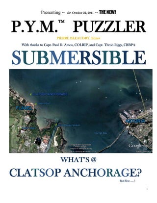
- 1. 1 Presenting -- for October 22, 2011 -- THE NEW! P.Y.M.™ PUZZLERPIERRE BLEAUDRY, Editor With thanks to Capt. Paul D. Amos, COLRIP, and Capt. Thron Riggs, CRBPA SUBMERSIBLE WHAT’S @ CLATSOP ANCHORAGE?But First ….. !
- 2. 2 WHICH DOyo UBe Li EVISION? Last week’s Puzzler asked the question of what happened to the DOUBLEVISION of the incorporators of the Oregon Central Railroad (OCR) (above – on the left) and/or the incorporators of the Willamette Valley Railroad (WVR) (above) (not above here, but off to the right) for construction of a MAGLEV rail line from Astoria to Portland, via the Klatskanine River to Saddle Mountain, and thence down the Nehalem River grade into the Tualatin Valley, turning east to Portland? The imperative of such an “inland” rail link between Portland and Astoria, looks back all the way to the Puzzler of October 9, 2011, and the vision of Sidney Dell for the development of Flavel …. or Astoria… one of which could soon see its growth leap-frogging ahead of that of Portland, or even Seattle, as the global economy shifts from a trans-Atlantic driver, to a trans-Pacific driver, in consequence of recent developments in Russia, and economic development alliance pledged between Putin and Wen Jiabao, on behalf of their two countries. Q.v. But what of the answer to the Puzzler? What happened to the DOUBLEVISION? The answer lies in the map on the following page, which was included in the published opinion of the United States Supreme Court, in, e.g., United States vs. Oregon Central Railroad, 176 U.S. 541, 544 (1896). This map shows rather dramatically that the vision of Joseph Gaston and the founders of the OCR was … detoured … or derailed by Congress, which was afflicted by its own kind of doublevision -- the disabling kind. For Congress, in its illustrious efficiency, set aside for the OCR two 20-mile swaths of public land – these have been marked in green on the map. One of these, makes a lefthand arc from about St. Helens on the Oregon side of the Columbia River, 15 miles north of Portland, through largely impassable mountains, ending in yet more mountains of the Coast range about 20 miles west of McMinnville. A railroad to nowhere. The other -- for a telegraph line -- runs from about the same, point, probably Kalama, or Woodland Washington, on the NORTH bank of the Columbia River to approximately Skamokawa, on Baker’s Bay, Washington -- some ten miles across the river, from Astoria (or twelve from Flavel). Leaving ten or twelve miles of open water over which to string the telegraph lines. Marked in red, is the actual Astoria to Portland route which the OCR had surveyed –a s shown in the Doublevision of John A Hurlburt.
- 3. 3 The result is that the Congressional setaside for the OCR was a far-fetched, incredible bungle, and hence completely useless, and so the vision for the development of this rail link was again lost. Congressional Doublevision for Development of this Critical Corridor Development of the Port of Flavel, however, or expansion of the Port of Astoria to include portions of Young’s Bay over to Flavel and Warrenton, require this rail line – or one based on the field surveys of John A. Hurlburt and the vision of the OCR and the WVR – to be developed, linking Astoria and Portland in a more direct MAGLEV line through the mountains, that also serves the growing communities of the Tualatin valley. The original OCR vision of a hub at Forest Grove (see map) is viable, but relocating a proposed hub seven miles north to the City of Banks, Oregon suits the more recent patterns of development along Hwy 26, as opposed to the original growth pattern along Baseline Road. Such development at Flavel however (or Astoria) must reckon with the archaeological heritage of the Clatsop Plain – both historic and prehistoric, and both Indian and white. Indeed, one of the unparalleled undiscovered archeological treasures of the Pacific coast of North America is in the Columbia River Estuary, and lies just off Tansy Point, underwater. But what is it? To find out, we must first see if the Puzzler you are reading is SUBMERSIBLE ………
- 4. 4 WHAT’S @ CLATSOP ANCHORAGE? MacArthur 1851 USCS Chart, Mouth of the Columbia Greg Walter Collection
- 5. 5 As all regular Players know, Lt. William P. McArthur, U.S.N. was in command of the U.S.C.S. hydrographic party, under the direction of Superintendent A.D. Bache, surveying the Pacific Coast of North America during the years 1849- 1851, with Lt. W.A. Bartlett, U.S.N. assisting. (See, e.g., Dromgoole, Who’s that Hydrographic Surveyor?” Puzzler Recapitulation, June 21, 2011; Elmendorf, If This is Sketch K, Where’s Sketches A-J? (October 7, 2010); The Bache is Back? (June 23, 2006) etc.. The Clatsop Anchorage is labeled on the completed USCS chart: note the feature marked as Clatsop Anchorage on that map, above ( preceding page)- and circled in yellow, which correlates to the satellite snapshot taken from Google Earth. As can be seen from these images, the Clatsop Anchorage lies off Tansy Point – not marked on the USCS map - - and beyond the shoals along the south bank of the Columbia, just downriver from the mouth of Young’s Bay ( at the large “Y”) -- in about 5 ½ fathoms, marked on the map. A copy of the map is available online, at the NOAA Historical Charts website http://historicalcharts.noaa.gov/historicals -- and of course the Google Earth imagery is accessible. As pointed out in a recent Puzzler, Astoria or Flavel, Which of these Two Budding Seaports …. (October 9, 2011) Tansy Point—a low-lying some might say inconspicuous, even unimpressive , promontory of the south bank of the Columbia River, near the edge of Young’s Bay which separates it from Astoria to the east, is also the land where Capt. George Flavel founded the townsite for Flavel, Oregon …. Following his shipwrecking on the beach in 1863, and trekking over Clatsop Spit “to where we had a boat,” Capt. Flavel had an insight, or stumbled upon something: and over the next year he returned there 5 or 6 times, although he did not land at Tansy Point, but “… generally landed down at Kindred’s place”. Abstract of Record, Deposition of George Flavel, pp. 306-307. The record of the case of Flavel Land and Development Commission vs. Leinenweber, and depositions indicates that Flavel took a particular interest in something that was offshore, in the estuary …
- 6. 6 The Amazing Capt. White & Clatsop Anchorage: Capt. George Flavel does not appear to have mentioned Tansy Point in connection with the Clatsop Anchorage, or discussed it in explaining his suddenly arising interest in Tansy Point, following his shipwreck. However, we can catch a glimpse of the early navigational significance of Tansy Point in the Oregon Spectator’s coverage of the arc of the amazing career of Capt. Charles White; and likewise therein, a reference to the Clatsop Anchorage. This image of a column from page 4, col. 4, of the Spectator for March 21, 1850, which prints an extract from Capt. Crosby, writing aboard his vessel, the Louisiana, very shortly after crossing the bar: Oregon Spectator, Mar 21, 1850 4:4. And note again here, Crosby’s final paragraph: “We lay three days at Anchor at Tanzy Point, Clatsop, with a heavy gale from S. W. to W. by N. and find it an excellent harbor, good holding ground and true tides – far superior to Bakers [bay]. The Clatsop anchorage off Tansy Point, is “an excellent harbor” – although in fact there is no evident harbor there, but, on the contrary, as Crosby noted, “this channel is straight,” and the anchorage is right alongside the channel. Even in the channel. See the image of the USCS chart, above. In addition, there is extreme exposure to winds – especially heavy gales “from S.W. to W,” that sweep unobstructed over the Clatsop plain. March is a good month in which to encounter these gale force winds: this Chinook Wind that also buffets Astoria in the winter, would more frequently blow as a gale over Clatsop plain onto Tansy Point, and tend to act on a vessel anchored at Tansy Point -- as Captain White had directed that the Louisiana be anchored – by pushing it away from the Tansy Point shore, directly out into the South Channel, thus placing the ship completely at the mercy of the “true tides” at this point, and the powerful river currents that scour the South Channel and keep it navigable.
- 7. 7 This is no harbor – but it must be a mighty good anchorage. Of course, this looks like devil-may-care seamanship: so positioned, if the Louisiana’s anchor does not hold, the ship will be immediately torn from “harbor” at Tansy Point, and – under a strong SW gale, probably irrecoverably captured by the river current, harried by the winds, and carried onto the shoals of Desdemona Sands, Sand Island, Clatsop Spit, or any of the many other unnamed shoals that threaten navigation. It is a recipe for shipwreck; and yet …. Capt. Crosby gives this strategy his enthusiastic endorsement! “What a ride!!!” Three days in a gale, in mortal danger!! Capt. Crosby’s Louisiana, was under the pilotage of Captain Charles White – and so, it was Capt. White who anchored for three days at Tansy Point, in heavy gales from the S.W. Therefore, it was Capt. White whose peerless expertise on the river, included knowledge of the Clatsop Anchorage as good enough “holding ground” to ride out a strong SSW gale. See Elmendorf, Who Discovered the South Channel of the Columbia River?” (February 10, 2001) Not incidentally, Capt. White must have provided to Lt. McArthur and the officers of the United States Coast Survey, the knowledge of Tansy Point as a superior anchorage. Here’s another reference to the Oregon City meeting of late April, 1850, in which Lt. McArthur’s showed his close acquaintanceship, and working relationship, with Capt. White. Oregon Spectator, May 2, 1850 Hence, Clatsop Anchorage is prominently marked on Lt. MacArthur’s USCS 1851 chart of the Mouth of the Columbia River. See p. 3. Clatsop Anchorage in the 1840’s. It appears that the initial location or identification of the Clatsop Anchorage, as a primary moorage for vessels seeking to trade at the Clatsop Plain -- either with whites or Indians – was yet earlier. This was evidently an item of seafaring lore, known – from direct observation – by sailing captains who traded up the Columbia River: a ship riding stationery at anchor, near a powerful river channel. Sailors from Boston and Newburyport, to name two eastern seaports that traded heavily on the Columbia, duly obliged one another by passing such lore from ship to ship.
- 8. 8 Clatsop Anchorage was used to trade with the Methodist Mission located on Clatsop Plain, in the early 1840’s, and officers of the U.S.S. Peacock stopped here in 1841, following the wreck of their vessel on the now-known-as- Peacock Spit. The Wilkes’ Expedition materials thus speak of Methodist mission on Clatsop Spit, in 1841, and Comm. Wilkes himself mentions a visit by Messrs. Richmond and Wilson, who had “recently arrived’ and settled within the few months prior to the wreck of the Peacock, and arrival of the U.S.S. Vincennes. Wilkes later returned the favor. See, Findlay, p. 361, in Directory of Navigation of the Pacific Ocean (1851) [Google book] Wilkes, after landing, had only to walk a mile to reach the Methodist Mission. He obviously anchored nearby – – took a boat ashore, and thereby reached the Mission. He must have dropped anchor at the Clatsop Anchorage. Wilkes U.S. Exploring Expedition, Map of the Oregon Territory (1841) Image courtesy www.davidrumsey.org The Wilkes Expedition Map of the Oregon Territory (1841) shows the “Meth. Mission” situated on the Clatsop Plain proximate to the shore along the Clatsop Channel. The only way to “walk a mile” to reach it, would be to anchor near the south channel, and boat ashore. The Clatsop Anchorage of the Methodist Mission Settlement While there is not much recent historiography on the Methodist Mission at Clatsop Plain in 1843, there is some very good first person history. In David Lee and H. Frost, Ten Years in Oregon, (1844) [Google Book] we can catch a glimpse of the Clatsop Anchorage serving this mission settlement p. 316 On the 2nd of April, [1842] I received a letter from the superintendent, which brought the sad intelligence of the death of his excellent wife, the particulars of which have already been given . I received a letter also from Mr. Kone by an American vessel, by which I learned that he expected to sail for the United States the 1st of this month. This [unnamed] vessel came for the purposes of trade. I boarded her in Baker’s bay, where I met with Mr. Birnie, who had reached the vessel before me ; and as part of the cargo was ardent spirits, we obtained a pledge from the captain and his first mate, to the effect that no liquor should be sold or given to the natives, in view of the fact that if they should become intoxicated, bloodshed and murder would ensue; and in view of [317] this pledge he was furnished with a house I my immediate neighborhood, in which to trade with the Indians for salmon. During the day the vessel came to anchor in the river opposite to my house. Some barrels and goods were landed , and a man left to trade. My sailor boy entered on board of this vessel, and left his Indian wife with us, who by this time had become quite a help to Mrs Frost …
- 9. 9 What’s at Clatsop Anchorage? There is no reason observable – so it seems – for this position on the south bank of the river, immediately along the South Channel, to have been deemed an “excellent harbor” – by Capt. Charles White, or any other captain. A visual inspection of Tansy Point – even a half dozen of them -- disclosed nothing geological to distinguish the … “Point” from any other “points” along this very muddy, sandy, low-lying land of the south bank of the Columbia. Any geological map of the area would confirm this impression. From, USC&GS, Navigational Chart for the Columbia River from Entrance to Upper Astoria (1905) image available at NOAA Historcial Charts website, http://historicalcharts.noaa.gov/historicals USGS Warrenton Quad Topogrpahical Available from http://www.usgs.gov However, the USGS Warrenton topographical chart shows an extensive field of “Ruins” immediately off Tansy Point at Flavel, precisely at Clatsop Anchorage, alongside the South Channel. There are other instances of ruins marked along this south shore, at Hammond, etc. – but they are less extensive. In addition there is no historical record of anything but one pier – Flavel’s – having been constructed at Tansy Point. So this week’s Puzzler is … WHAT’S @ CLATSOP ANCHORAGE? NEXT WEEK: There has been some talk, including with counsel, over whether to bring back our regular editor. Following the intimations of E.G.S. LaRue Al-Raouche, of the O.M.I.G.O.d., a conference panel has been convened within the Simultaneity of Eternity Astral Network to review this prospect, and to consider possible Puzzler topics, vis-à- vis ongoing Player Class Action litigation, Suzy Cue, et al, vs. the P.Y.M. Puzzler, et al., which we had hoped to settle by providing extra hints (AHaH!s) to members of the class-- and we even offered to convert these Players’ subscriptions over to a proposed new “sister” publication geared more towards beginners. This has not been approved by the class. Etc. More later. P.