A Landscape of Citizen Observatories in Europe - EuroGEOSS Poster
•
1 like•121 views

This document summarizes work to define citizen observatories and map existing initiatives across Europe. It reviewed literature for a consolidated definition of citizen observatories and frameworks for classifying initiatives based on characteristics like geographic scope, participants, data accessibility, and more. Existing citizen observatory projects from the EU's Horizon 2020 and FP7 programs are mapped according to these classifications to benchmark features and functions. Practitioners are invited to share additional project details to compile a more comprehensive landscape of citizen observatory initiatives in Europe.
Recommended

Recommended
More Related Content
What's hot
What's hot (20)
Similar to A Landscape of Citizen Observatories in Europe - EuroGEOSS Poster
Similar to A Landscape of Citizen Observatories in Europe - EuroGEOSS Poster (20)
More from Margaret Gold
More from Margaret Gold (20)
Recently uploaded
Recently uploaded (20)
A Landscape of Citizen Observatories in Europe - EuroGEOSS Poster
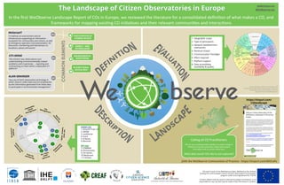
- 1. In the first WeObserve Landscape Report of COs in Europe, we reviewed the literature for a consolidated defini=on of what makes a CO, and frameworks for mapping exis=ng CO ini=a=ves and their relevant communi=es and interac=ons WeSenseIT “a method, an environment and an infrastructure supporting an information ecosystem for communities and citizens, as well as emergency operators and policymakers, for discussion, monitoring and intervention on situations, places and events” 2013 PARTICIPATION OF CITIZENS ‘IN-SITU’ https://tinyurl.com/ COlandscape COMMONELEMENTS 1. Geographic scope 2. Type of participants 3. Network establishment mechanism 4. Revenue stream 5. Communication Paradigm 6. Effort required 7. Platform support 8. Data accessibility, availability & quality 1 Geographic scope & no. of member stations 2 Type of Participants 3 Network establishment mechanism 4 Revenue stream to sustain the network 5 Communication paradigm 6 Effort required by data sharers 7 Support offered by platform providers 8 Data accessibility, availability & quality Dimensions ↔ (Scien=fic) experts Private sector NGOs Emergency services Local authori=es Na=onal organiza=ons Regional organiza=ons Interna=onal organiza=ons BoKom Up Adver=sing Licencing Dona=on Uni-‐direc=onal Knowledge requirements Diversiy of supported sensor types Suppor=ng material Usability of the web-‐plaRorm Usability of the app ← Classifications → Citizen Observatories Source: Gharesifard, Wehn, & van der Zaag, 2017 Towards benchmarking Ci=zen Observatories: Features and func=oning of online amateur weather networks. Journal of Environmental Management. CityManagement Water,streams, snow,sea Air, noise, smell spectrum Tools formonitoring Disaster monitoring Commodity- based Management 1 2 3 Secondary 4 5 7 6 7 9 9 8 9 8 10 11 H2020 COs 1. Ground Truth 2.0 2. GROW 3. LandSense 4. Scent 5. D-Noses 6. Monocle FP7 COs 7. COBWEB 8. Ominscientis 9. Citi-Sense 10. WeSenseIt 11. Citiclops ENVIRONMENTAL MONITORING BI-DIRECTIONAL DATA & INFO MOBILE + WEB TECHNOLOGIES ALAN GRAINGER “any use of Earth observation technology in which citizens collect data and are empowered by the information generated from these data to participate in environmental management.” 2017 CITI-SENSE “the citizens’ own observations and understanding of environmentally related problems and in particular ... reporting and commenting on them within a dedicated ICT platform” 2014 Calling all CO Prac==oners We are now compiling project details on as wide a range of ini=a=ves in Europe as possible. Please share project informa=on with us via this online form. What data would YOU like to see captured? JOIN the WeObserve Communities of Practice - https://tinyurl.com/WOCoPs This work is part of the WeObserve project. WeObserve has received funding from the European Union’s Horizon 2020 research & innovation program under Grant Agreement No 776740. Content reflects only the author’s view and European Commission is not responsible for any use that may be made of the information it contains. @WeObserve WeObserve.eu