SlideShare ist ein Scribd-Unternehmen logo
1 von 2
Physical methods of subsurface mapping
The following five types are mentioned below,
1. Seismic surveys:
Seismic survey arethe most common ones and the most usefultechnique for this
purpose. The Earth comprises of many different layers with various thicknesses
and densities.
In this method, a sourceof energy fromthe surfaceoccurs, waves of energy are
reflected and refracted back towards the surfaceat different velocities and times.
Geophones are placed all over the earth and record these seismic waves. These
waves are then sent to a seismogramthat generates a seismic station or basically
a 2D slice of the Earth below the surface.
Itis then further divided into Seismic Refraction, Seismic Reflection and Surface
wavesurvey.
SeismicReflection SurveyinSea
Benefits: This station tells us, types of rock, their depth, and the presenceof
unconformities. The reason that this is the mostcommon survey method is
because wecan create our own shock waves fromthe surfaceand get readings of
the Earth wherever we need them.
2. Gravity Surveys:
Such survey is generally done using gravimeters (an instrumentfor measuring the
difference in the forceof gravity fromone place to another), which measure
variations in the gravitational field on Earth. Denser rocks emit a greater
gravitational field allowing geophysicists to get a good idea of how deep these
certain rock layers are.
3. Magnetometer Surveys:
These surveys arecompleted by dragging or pulling a
magnetometer behind a ship or airplane. This magnetometer
detects slight shifts in Earth’s magnetic fields indicating how
deep certain magnetized rocks areburied.
4. Magneto-telluric or (MT) Surveys:
Itoperates on the principle that different rocks have different
electrical properties. Geophysicists measurethe naturally occurring flow of
electricity at different depths and usethat info to create electromagnetic images
of subsurfaceformations.
5. Magnetic and Electromagnetic Surveys:
These surveys allow geophysicists to get a better understanding and picture of
the configuration of subsurfacerock formations becauseof magnetic fields
emitted by minerals in different types of rocks. This typeof survey is very useful
to find faults.
MagnetometerSurvey

Weitere ähnliche Inhalte

Was ist angesagt?

Was ist angesagt? (20)

Shear zones.
Shear zones.Shear zones.
Shear zones.
 
Geophysical prospecting
Geophysical prospecting Geophysical prospecting
Geophysical prospecting
 
Geophysical exploration
Geophysical exploration Geophysical exploration
Geophysical exploration
 
Geophysical studies
Geophysical studiesGeophysical studies
Geophysical studies
 
Migmatite and metamorphism
Migmatite and metamorphismMigmatite and metamorphism
Migmatite and metamorphism
 
Gravity Method
Gravity MethodGravity Method
Gravity Method
 
Geological mapping
Geological mappingGeological mapping
Geological mapping
 
Cuddapah supergroup
Cuddapah supergroupCuddapah supergroup
Cuddapah supergroup
 
GROUNDWATER LEVEL FLUCTUATION
GROUNDWATER LEVEL FLUCTUATIONGROUNDWATER LEVEL FLUCTUATION
GROUNDWATER LEVEL FLUCTUATION
 
Introduction to Seismic Method
Introduction to Seismic Method Introduction to Seismic Method
Introduction to Seismic Method
 
Groundwater Investigation Techniques-Geophysical Methods
Groundwater Investigation Techniques-Geophysical MethodsGroundwater Investigation Techniques-Geophysical Methods
Groundwater Investigation Techniques-Geophysical Methods
 
Stress and strain ellipsoid
Stress and strain ellipsoidStress and strain ellipsoid
Stress and strain ellipsoid
 
Presentation on geophysical methods
Presentation on geophysical methodsPresentation on geophysical methods
Presentation on geophysical methods
 
Facies Concept
Facies ConceptFacies Concept
Facies Concept
 
Gravity Method | Geophysics | Geology
Gravity Method | Geophysics | GeologyGravity Method | Geophysics | Geology
Gravity Method | Geophysics | Geology
 
Seismic stratigraphy
Seismic stratigraphySeismic stratigraphy
Seismic stratigraphy
 
Resistivity method
Resistivity method Resistivity method
Resistivity method
 
Geophysical methods
Geophysical methodsGeophysical methods
Geophysical methods
 
joints and its classification and its recognition
joints and its classification and its recognitionjoints and its classification and its recognition
joints and its classification and its recognition
 
Dharwar super group
Dharwar super groupDharwar super group
Dharwar super group
 

Ähnlich wie Seismic surveys: The most common physical method for subsurface mapping

lect 4- petroleum exploration- part1.pdf
lect 4- petroleum exploration- part1.pdflect 4- petroleum exploration- part1.pdf
lect 4- petroleum exploration- part1.pdftahahaider8
 
Similarities between gravity and magnetics and application of different geoph...
Similarities between gravity and magnetics and application of different geoph...Similarities between gravity and magnetics and application of different geoph...
Similarities between gravity and magnetics and application of different geoph...Jyoti Khatiwada
 
reflectingmethodofseismicprospecting-170911184242.pdf
reflectingmethodofseismicprospecting-170911184242.pdfreflectingmethodofseismicprospecting-170911184242.pdf
reflectingmethodofseismicprospecting-170911184242.pdf3flatun1111
 
Reflecting method of seismic prospecting
Reflecting method of seismic  prospectingReflecting method of seismic  prospecting
Reflecting method of seismic prospectingPramoda Raj
 
geotechnical investigation in civil engineering
geotechnical investigation in civil engineeringgeotechnical investigation in civil engineering
geotechnical investigation in civil engineeringJayakrishnan Jk
 
Geophysical Exploration
Geophysical ExplorationGeophysical Exploration
Geophysical ExplorationSohail Nawab
 
Geophysical Methods and interpretation of its data
Geophysical Methods and interpretation of its dataGeophysical Methods and interpretation of its data
Geophysical Methods and interpretation of its dataNaserDZulfiqar
 
EARTHQUAKE ENGINEERING 1
EARTHQUAKE ENGINEERING 1EARTHQUAKE ENGINEERING 1
EARTHQUAKE ENGINEERING 1Edz Gapuz
 
Exploration and Exploitation Groundwater From Journal and Materials
Exploration and Exploitation Groundwater From Journal and MaterialsExploration and Exploitation Groundwater From Journal and Materials
Exploration and Exploitation Groundwater From Journal and MaterialsMartheana Kencanawati
 
EARTH QUACK AND ITS TYPES BRIEFLY EXPLAIN
EARTH QUACK AND ITS TYPES BRIEFLY EXPLAINEARTH QUACK AND ITS TYPES BRIEFLY EXPLAIN
EARTH QUACK AND ITS TYPES BRIEFLY EXPLAINHafiz JUNAID
 
Marine Geophysics
Marine GeophysicsMarine Geophysics
Marine GeophysicsHafez Ahmad
 
Applications Gravity survey Magnetic survey Electrical resistivity survey Sei...
Applications Gravity survey Magnetic survey Electrical resistivity survey Sei...Applications Gravity survey Magnetic survey Electrical resistivity survey Sei...
Applications Gravity survey Magnetic survey Electrical resistivity survey Sei...University of Azad Jammu & Kashmir
 
SEISMIC SIGNALS.pdf
SEISMIC SIGNALS.pdfSEISMIC SIGNALS.pdf
SEISMIC SIGNALS.pdfSejalWasule
 
Similarities and differences between gravity and magnetic
Similarities and differences between gravity and magneticSimilarities and differences between gravity and magnetic
Similarities and differences between gravity and magneticAkhtar Hussain
 
Eq power point presentation
Eq  power point presentationEq  power point presentation
Eq power point presentationnelluru
 
Earthquake engineering
Earthquake engineeringEarthquake engineering
Earthquake engineeringParth Desani
 

Ähnlich wie Seismic surveys: The most common physical method for subsurface mapping (20)

lect 4- petroleum exploration- part1.pdf
lect 4- petroleum exploration- part1.pdflect 4- petroleum exploration- part1.pdf
lect 4- petroleum exploration- part1.pdf
 
Similarities between gravity and magnetics and application of different geoph...
Similarities between gravity and magnetics and application of different geoph...Similarities between gravity and magnetics and application of different geoph...
Similarities between gravity and magnetics and application of different geoph...
 
Unit 5
Unit 5Unit 5
Unit 5
 
reflectingmethodofseismicprospecting-170911184242.pdf
reflectingmethodofseismicprospecting-170911184242.pdfreflectingmethodofseismicprospecting-170911184242.pdf
reflectingmethodofseismicprospecting-170911184242.pdf
 
Reflecting method of seismic prospecting
Reflecting method of seismic  prospectingReflecting method of seismic  prospecting
Reflecting method of seismic prospecting
 
geotechnical investigation in civil engineering
geotechnical investigation in civil engineeringgeotechnical investigation in civil engineering
geotechnical investigation in civil engineering
 
Lecture-10.pptx
Lecture-10.pptxLecture-10.pptx
Lecture-10.pptx
 
Geophysical Exploration
Geophysical ExplorationGeophysical Exploration
Geophysical Exploration
 
Geophysical Methods and interpretation of its data
Geophysical Methods and interpretation of its dataGeophysical Methods and interpretation of its data
Geophysical Methods and interpretation of its data
 
EARTHQUAKE ENGINEERING 1
EARTHQUAKE ENGINEERING 1EARTHQUAKE ENGINEERING 1
EARTHQUAKE ENGINEERING 1
 
Exploration and Exploitation Groundwater From Journal and Materials
Exploration and Exploitation Groundwater From Journal and MaterialsExploration and Exploitation Groundwater From Journal and Materials
Exploration and Exploitation Groundwater From Journal and Materials
 
EARTH QUACK AND ITS TYPES BRIEFLY EXPLAIN
EARTH QUACK AND ITS TYPES BRIEFLY EXPLAINEARTH QUACK AND ITS TYPES BRIEFLY EXPLAIN
EARTH QUACK AND ITS TYPES BRIEFLY EXPLAIN
 
Geophysical methods
Geophysical methodsGeophysical methods
Geophysical methods
 
Marine Geophysics
Marine GeophysicsMarine Geophysics
Marine Geophysics
 
Applications Gravity survey Magnetic survey Electrical resistivity survey Sei...
Applications Gravity survey Magnetic survey Electrical resistivity survey Sei...Applications Gravity survey Magnetic survey Electrical resistivity survey Sei...
Applications Gravity survey Magnetic survey Electrical resistivity survey Sei...
 
Earthquake seismology
Earthquake seismologyEarthquake seismology
Earthquake seismology
 
SEISMIC SIGNALS.pdf
SEISMIC SIGNALS.pdfSEISMIC SIGNALS.pdf
SEISMIC SIGNALS.pdf
 
Similarities and differences between gravity and magnetic
Similarities and differences between gravity and magneticSimilarities and differences between gravity and magnetic
Similarities and differences between gravity and magnetic
 
Eq power point presentation
Eq  power point presentationEq  power point presentation
Eq power point presentation
 
Earthquake engineering
Earthquake engineeringEarthquake engineering
Earthquake engineering
 

Mehr von Maliha Mehr

Types of bonds in brick masonry
Types of bonds in brick masonryTypes of bonds in brick masonry
Types of bonds in brick masonryMaliha Mehr
 
Interlocking Bricks
Interlocking BricksInterlocking Bricks
Interlocking BricksMaliha Mehr
 
Types of Concrete
Types of ConcreteTypes of Concrete
Types of ConcreteMaliha Mehr
 
Types of Paint with Application
Types of Paint with ApplicationTypes of Paint with Application
Types of Paint with ApplicationMaliha Mehr
 
Types of deep foundation
Types of deep foundationTypes of deep foundation
Types of deep foundationMaliha Mehr
 
Recursion in C++
Recursion in C++Recursion in C++
Recursion in C++Maliha Mehr
 
Labor Problems, Their Prevention and Settlement
Labor Problems, Their Prevention and Settlement Labor Problems, Their Prevention and Settlement
Labor Problems, Their Prevention and Settlement Maliha Mehr
 
Buoyancy and Flotation
Buoyancy and FlotationBuoyancy and Flotation
Buoyancy and FlotationMaliha Mehr
 
Rectangular and Circular underground water tank
Rectangular and Circular underground water tank Rectangular and Circular underground water tank
Rectangular and Circular underground water tank Maliha Mehr
 
Concrete blocks and their types
Concrete blocks and their typesConcrete blocks and their types
Concrete blocks and their typesMaliha Mehr
 
Geological Subsurface Maps
Geological Subsurface MapsGeological Subsurface Maps
Geological Subsurface MapsMaliha Mehr
 
Topography and Topographical Maps
Topography and Topographical Maps Topography and Topographical Maps
Topography and Topographical Maps Maliha Mehr
 
Metamorphic rocks
Metamorphic rocks Metamorphic rocks
Metamorphic rocks Maliha Mehr
 
HVAC System (Heating, Ventilation and Air Conditioning)
HVAC System (Heating, Ventilation and Air Conditioning)HVAC System (Heating, Ventilation and Air Conditioning)
HVAC System (Heating, Ventilation and Air Conditioning)Maliha Mehr
 
Issues arising due to lack of project management
Issues arising due to lack of project managementIssues arising due to lack of project management
Issues arising due to lack of project managementMaliha Mehr
 
Project Management Training
Project Management TrainingProject Management Training
Project Management TrainingMaliha Mehr
 
Wood and its types
Wood and its typesWood and its types
Wood and its typesMaliha Mehr
 

Mehr von Maliha Mehr (20)

Types of bonds in brick masonry
Types of bonds in brick masonryTypes of bonds in brick masonry
Types of bonds in brick masonry
 
Interlocking Bricks
Interlocking BricksInterlocking Bricks
Interlocking Bricks
 
Types of Concrete
Types of ConcreteTypes of Concrete
Types of Concrete
 
Types of Paint with Application
Types of Paint with ApplicationTypes of Paint with Application
Types of Paint with Application
 
Types of deep foundation
Types of deep foundationTypes of deep foundation
Types of deep foundation
 
Arrays in C++
Arrays in C++Arrays in C++
Arrays in C++
 
Recursion in C++
Recursion in C++Recursion in C++
Recursion in C++
 
Labor Problems, Their Prevention and Settlement
Labor Problems, Their Prevention and Settlement Labor Problems, Their Prevention and Settlement
Labor Problems, Their Prevention and Settlement
 
Buoyancy and Flotation
Buoyancy and FlotationBuoyancy and Flotation
Buoyancy and Flotation
 
Rotameter
Rotameter Rotameter
Rotameter
 
Rectangular and Circular underground water tank
Rectangular and Circular underground water tank Rectangular and Circular underground water tank
Rectangular and Circular underground water tank
 
Concrete blocks and their types
Concrete blocks and their typesConcrete blocks and their types
Concrete blocks and their types
 
Types of Stairs
Types of StairsTypes of Stairs
Types of Stairs
 
Geological Subsurface Maps
Geological Subsurface MapsGeological Subsurface Maps
Geological Subsurface Maps
 
Topography and Topographical Maps
Topography and Topographical Maps Topography and Topographical Maps
Topography and Topographical Maps
 
Metamorphic rocks
Metamorphic rocks Metamorphic rocks
Metamorphic rocks
 
HVAC System (Heating, Ventilation and Air Conditioning)
HVAC System (Heating, Ventilation and Air Conditioning)HVAC System (Heating, Ventilation and Air Conditioning)
HVAC System (Heating, Ventilation and Air Conditioning)
 
Issues arising due to lack of project management
Issues arising due to lack of project managementIssues arising due to lack of project management
Issues arising due to lack of project management
 
Project Management Training
Project Management TrainingProject Management Training
Project Management Training
 
Wood and its types
Wood and its typesWood and its types
Wood and its types
 

Kürzlich hochgeladen

complete construction, environmental and economics information of biomass com...
complete construction, environmental and economics information of biomass com...complete construction, environmental and economics information of biomass com...
complete construction, environmental and economics information of biomass com...asadnawaz62
 
Industrial Safety Unit-IV workplace health and safety.ppt
Industrial Safety Unit-IV workplace health and safety.pptIndustrial Safety Unit-IV workplace health and safety.ppt
Industrial Safety Unit-IV workplace health and safety.pptNarmatha D
 
Internet of things -Arshdeep Bahga .pptx
Internet of things -Arshdeep Bahga .pptxInternet of things -Arshdeep Bahga .pptx
Internet of things -Arshdeep Bahga .pptxVelmuruganTECE
 
List of Accredited Concrete Batching Plant.pdf
List of Accredited Concrete Batching Plant.pdfList of Accredited Concrete Batching Plant.pdf
List of Accredited Concrete Batching Plant.pdfisabel213075
 
THE SENDAI FRAMEWORK FOR DISASTER RISK REDUCTION
THE SENDAI FRAMEWORK FOR DISASTER RISK REDUCTIONTHE SENDAI FRAMEWORK FOR DISASTER RISK REDUCTION
THE SENDAI FRAMEWORK FOR DISASTER RISK REDUCTIONjhunlian
 
Input Output Management in Operating System
Input Output Management in Operating SystemInput Output Management in Operating System
Input Output Management in Operating SystemRashmi Bhat
 
Engineering Drawing section of solid
Engineering Drawing     section of solidEngineering Drawing     section of solid
Engineering Drawing section of solidnamansinghjarodiya
 
Research Methodology for Engineering pdf
Research Methodology for Engineering pdfResearch Methodology for Engineering pdf
Research Methodology for Engineering pdfCaalaaAbdulkerim
 
Earthing details of Electrical Substation
Earthing details of Electrical SubstationEarthing details of Electrical Substation
Earthing details of Electrical Substationstephanwindworld
 
Mine Environment II Lab_MI10448MI__________.pptx
Mine Environment II Lab_MI10448MI__________.pptxMine Environment II Lab_MI10448MI__________.pptx
Mine Environment II Lab_MI10448MI__________.pptxRomil Mishra
 
Cooling Tower SERD pH drop issue (11 April 2024) .pptx
Cooling Tower SERD pH drop issue (11 April 2024) .pptxCooling Tower SERD pH drop issue (11 April 2024) .pptx
Cooling Tower SERD pH drop issue (11 April 2024) .pptxmamansuratman0253
 
"Exploring the Essential Functions and Design Considerations of Spillways in ...
"Exploring the Essential Functions and Design Considerations of Spillways in ..."Exploring the Essential Functions and Design Considerations of Spillways in ...
"Exploring the Essential Functions and Design Considerations of Spillways in ...Erbil Polytechnic University
 
DM Pillar Training Manual.ppt will be useful in deploying TPM in project
DM Pillar Training Manual.ppt will be useful in deploying TPM in projectDM Pillar Training Manual.ppt will be useful in deploying TPM in project
DM Pillar Training Manual.ppt will be useful in deploying TPM in projectssuserb6619e
 
11. Properties of Liquid Fuels in Energy Engineering.pdf
11. Properties of Liquid Fuels in Energy Engineering.pdf11. Properties of Liquid Fuels in Energy Engineering.pdf
11. Properties of Liquid Fuels in Energy Engineering.pdfHafizMudaserAhmad
 
Risk Management in Engineering Construction Project
Risk Management in Engineering Construction ProjectRisk Management in Engineering Construction Project
Risk Management in Engineering Construction ProjectErbil Polytechnic University
 
Gravity concentration_MI20612MI_________
Gravity concentration_MI20612MI_________Gravity concentration_MI20612MI_________
Gravity concentration_MI20612MI_________Romil Mishra
 
Virtual memory management in Operating System
Virtual memory management in Operating SystemVirtual memory management in Operating System
Virtual memory management in Operating SystemRashmi Bhat
 
National Level Hackathon Participation Certificate.pdf
National Level Hackathon Participation Certificate.pdfNational Level Hackathon Participation Certificate.pdf
National Level Hackathon Participation Certificate.pdfRajuKanojiya4
 

Kürzlich hochgeladen (20)

complete construction, environmental and economics information of biomass com...
complete construction, environmental and economics information of biomass com...complete construction, environmental and economics information of biomass com...
complete construction, environmental and economics information of biomass com...
 
Industrial Safety Unit-IV workplace health and safety.ppt
Industrial Safety Unit-IV workplace health and safety.pptIndustrial Safety Unit-IV workplace health and safety.ppt
Industrial Safety Unit-IV workplace health and safety.ppt
 
Internet of things -Arshdeep Bahga .pptx
Internet of things -Arshdeep Bahga .pptxInternet of things -Arshdeep Bahga .pptx
Internet of things -Arshdeep Bahga .pptx
 
List of Accredited Concrete Batching Plant.pdf
List of Accredited Concrete Batching Plant.pdfList of Accredited Concrete Batching Plant.pdf
List of Accredited Concrete Batching Plant.pdf
 
THE SENDAI FRAMEWORK FOR DISASTER RISK REDUCTION
THE SENDAI FRAMEWORK FOR DISASTER RISK REDUCTIONTHE SENDAI FRAMEWORK FOR DISASTER RISK REDUCTION
THE SENDAI FRAMEWORK FOR DISASTER RISK REDUCTION
 
Input Output Management in Operating System
Input Output Management in Operating SystemInput Output Management in Operating System
Input Output Management in Operating System
 
Engineering Drawing section of solid
Engineering Drawing     section of solidEngineering Drawing     section of solid
Engineering Drawing section of solid
 
Design and analysis of solar grass cutter.pdf
Design and analysis of solar grass cutter.pdfDesign and analysis of solar grass cutter.pdf
Design and analysis of solar grass cutter.pdf
 
Research Methodology for Engineering pdf
Research Methodology for Engineering pdfResearch Methodology for Engineering pdf
Research Methodology for Engineering pdf
 
Earthing details of Electrical Substation
Earthing details of Electrical SubstationEarthing details of Electrical Substation
Earthing details of Electrical Substation
 
Mine Environment II Lab_MI10448MI__________.pptx
Mine Environment II Lab_MI10448MI__________.pptxMine Environment II Lab_MI10448MI__________.pptx
Mine Environment II Lab_MI10448MI__________.pptx
 
Cooling Tower SERD pH drop issue (11 April 2024) .pptx
Cooling Tower SERD pH drop issue (11 April 2024) .pptxCooling Tower SERD pH drop issue (11 April 2024) .pptx
Cooling Tower SERD pH drop issue (11 April 2024) .pptx
 
"Exploring the Essential Functions and Design Considerations of Spillways in ...
"Exploring the Essential Functions and Design Considerations of Spillways in ..."Exploring the Essential Functions and Design Considerations of Spillways in ...
"Exploring the Essential Functions and Design Considerations of Spillways in ...
 
DM Pillar Training Manual.ppt will be useful in deploying TPM in project
DM Pillar Training Manual.ppt will be useful in deploying TPM in projectDM Pillar Training Manual.ppt will be useful in deploying TPM in project
DM Pillar Training Manual.ppt will be useful in deploying TPM in project
 
11. Properties of Liquid Fuels in Energy Engineering.pdf
11. Properties of Liquid Fuels in Energy Engineering.pdf11. Properties of Liquid Fuels in Energy Engineering.pdf
11. Properties of Liquid Fuels in Energy Engineering.pdf
 
Risk Management in Engineering Construction Project
Risk Management in Engineering Construction ProjectRisk Management in Engineering Construction Project
Risk Management in Engineering Construction Project
 
Designing pile caps according to ACI 318-19.pptx
Designing pile caps according to ACI 318-19.pptxDesigning pile caps according to ACI 318-19.pptx
Designing pile caps according to ACI 318-19.pptx
 
Gravity concentration_MI20612MI_________
Gravity concentration_MI20612MI_________Gravity concentration_MI20612MI_________
Gravity concentration_MI20612MI_________
 
Virtual memory management in Operating System
Virtual memory management in Operating SystemVirtual memory management in Operating System
Virtual memory management in Operating System
 
National Level Hackathon Participation Certificate.pdf
National Level Hackathon Participation Certificate.pdfNational Level Hackathon Participation Certificate.pdf
National Level Hackathon Participation Certificate.pdf
 

Seismic surveys: The most common physical method for subsurface mapping

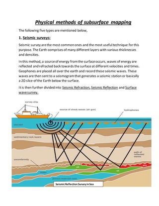
  • 1. Physical methods of subsurface mapping The following five types are mentioned below, 1. Seismic surveys: Seismic survey arethe most common ones and the most usefultechnique for this purpose. The Earth comprises of many different layers with various thicknesses and densities. In this method, a sourceof energy fromthe surfaceoccurs, waves of energy are reflected and refracted back towards the surfaceat different velocities and times. Geophones are placed all over the earth and record these seismic waves. These waves are then sent to a seismogramthat generates a seismic station or basically a 2D slice of the Earth below the surface. Itis then further divided into Seismic Refraction, Seismic Reflection and Surface wavesurvey. SeismicReflection SurveyinSea
  • 2. Benefits: This station tells us, types of rock, their depth, and the presenceof unconformities. The reason that this is the mostcommon survey method is because wecan create our own shock waves fromthe surfaceand get readings of the Earth wherever we need them. 2. Gravity Surveys: Such survey is generally done using gravimeters (an instrumentfor measuring the difference in the forceof gravity fromone place to another), which measure variations in the gravitational field on Earth. Denser rocks emit a greater gravitational field allowing geophysicists to get a good idea of how deep these certain rock layers are. 3. Magnetometer Surveys: These surveys arecompleted by dragging or pulling a magnetometer behind a ship or airplane. This magnetometer detects slight shifts in Earth’s magnetic fields indicating how deep certain magnetized rocks areburied. 4. Magneto-telluric or (MT) Surveys: Itoperates on the principle that different rocks have different electrical properties. Geophysicists measurethe naturally occurring flow of electricity at different depths and usethat info to create electromagnetic images of subsurfaceformations. 5. Magnetic and Electromagnetic Surveys: These surveys allow geophysicists to get a better understanding and picture of the configuration of subsurfacerock formations becauseof magnetic fields emitted by minerals in different types of rocks. This typeof survey is very useful to find faults. MagnetometerSurvey