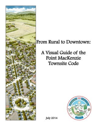
1. From Rural to Downtown:
A Visual Guide of the
Point MacKenzie
Townsite Code
July 2014
2. 2
This Visual Guide is for reference only.
It is intended to be used with the Point MacKenzie Townsite Development Code.
The draft Point MacKenzie Townsite Code standards found in this brochure, if accepted by the Assembly,
will assist with the development of the town site. As the Knik Arm Bridge becomes more of a potential
reality, a plan needs to be in place to make the best use of available lands, and to create a traditional town
in which people will enjoy residing in, recreating, and visiting.
Imagine many years from now, when then the area is developed into a town.
Then into a full-fledged gateway city to the bountiful opportunities available in the Alaskan Interior.
A city with attractive neighborhoods where people can live locally and feel part of a vibrant community.
A city that attracts and supports a variety of residents, activities, and economic opportunities.
If properly implemented, the Code, will fulfill that vision.
For further information please contact:
Matanuska-Susitna Planning Department
Planning & Land Use Division
350 E. Dahlia Avenue
Palmer, Alaska 99645
(907)861-7833
www.matsugov.us
3. 3
Point
MacKenzie
Townsite
Point MacKenzie
Townsite Facts
Matanuska-Susitna
Borough owned land
Approximately 2,100
acres (3.25 mi/sq)
Surrounded by private,
State, and CIRI lands.
PointMacKenzieRoad
Goose Creek
Correctional
Center
Where is the Point MacKenzie Townsite located?
Knik Arm
Bridge Site
Anchorage
Port
MacKenzie
4. 4
What is the Townsite Code?
The code would create the guidelines for a town developed in a series of transitional districts similar to
Palmer or an older city in the mid-west. There would be a transition from sparsely populated rural areas
into a defined town edge that leads into a densely inhabited town core. An emphasis is placed upon the
placement of buildings, streets, and civic spaces rather than land use to create a vibrant walkable mixed use
community with a high quality of life. The image below provides an example of this transition:
How is the Townsite Code different than Conventional Zoning?
Conventional Zoning
Single use zoning
Regulates zones for each land use type
Rigid use of lot sizes & building placement
Segregation of land uses
Auto dominated streets with large parking islands
Uniformity in neighborhoods (i.e. buildings, unit
size, zoning, income, & landscape)
Limited ability to affect change to the landscape
Rigid setbacks far from the street
Focus on site and little on right-of-way or landscape
Town Site Code
Mixed uses with a de-emphasis of land use zoning
Regulates building site form
Emphasis on building relationships, fitting building
to its use & surroundings
Pedestrian friendly network of multimodal streets
Diversity in neighborhoods (i.e. buildings, unit size,
zoning, income, & landscape)
Ability to transform or preserve the neighborhood
Build to lines allow custom building to the site
Buildings allowed closer to streets
Attention to street right-of-way & landscape
Rural Urban
5. 5
What would the Townsite Code look like at street level?
District 1: Natural (D1)
Lands in a natural state. Generally unsuitable for
development. Used for regional parks,
recreation, trails, wildlife habitat, and open
space. §17.24.050(C)
District 2: Rural (D2)
Low density, large rural residential lots, in open
or cultivated states. Agriculture, livestock, and
commercial lots may be present. Playgrounds,
parks, and trails provide recreation
opportunities. §17.24.050(D)
District 3: Residential (D3)
Primarily low to medium density detached
residential development. Houses can be up to
two stories tall. Walkable neighborhoods with
slow traffic safe for children who can play
neighborhood parks. §17.24.050(E)
District 4: Mixed Use (D4)
Neighborhoods of medium to high density. Mix
of two to three story buildings with shallow
front setbacks for mixed use such as detached
and attached residential houses, small apartment
buildings, and small commercial or mixed use
buildings. Walkable neighborhood blocks with
connected streets and interesting development
contribute to a sense of place. Public frontages
encourage pedestrian use which encourages
interactions of neighbors as they go about their
daily business. Public spaces include
playgrounds, neighborhood parks, and squares.
§17.24.050(F)
District 5: Town Core (D5)
High density town core with a mix of two to four
story buildings with shallow or no front
setbacks. Mixed use of buildings occupied by
attached residential houses, apartments, and
commercial or mixed use buildings. Walkable
neighborhood blocks with connected streets and
interesting development contribute to a sense of
place. Public frontages encourage pedestrian use
which encourages interactions of neighbors as
they go about their daily business. Playgrounds,
squares, and plazas provide public spaces for
recreation. §17.24.050(G)
6. 6
District 1: Natural (D1)
The Great Land Trust of
Southcentral Alaska has
identified Community
Assets. To the extent
possible, these areas and
their links will be
incorporated as D1 Natural
Areas, if located within the
Point MacKenzie Townsite.
Other natural areas will be
set aside as parks and civic
spaces as development
occurs.
7. 7
Lot Standards
1 unit per 5 acres
200’ minimum & no maximum
width for lot
No more than 10% impervious
surface
Lot Setbacks
Front: 40’ minimum
Street side: 40’ minimum
Internal side: 40’ minimum
Rear: 100’ minimum
Build-to-Zone: not required
Primary Building Design
1 to 2 floors + optional basement
Ground floor maximum 5’
elevation
35’ maximum height
Entrance on front of building
Minimum 15% windows
Outbuilding Design
1 to 2 floors
24’ maximum height elevation
Parking & Outbuilding Setbacks
Same as Lot Setbacks
Road Types & Standards (minimum dimensions shown)
Two Lane Two Lane with Center Turn Lane Four Lane
35’max.
5’
max. Optional Basement
2 Floor max.
2 Floor max.
Building Standards
24’max.
Lot LineRoad
Road
Shoulder
Shoulder
Buildable Area
(Primary, Outbuildings, & Parking)
Buildable
Area
Buildable
Area
200’ Minimum
Lot Width
40’ min. 40’ min. 40’ min.
40’min.
40’min.
40’min.
40’ min.
40’min.
100’ min.
100’ min.
Primary
Building
Garage
Outbuilding
100’min.
100’ min.
District 2: Rural (D2)
(refer to Table 17.24.150)
8. 8
Lot Standards
3 to 8 units per acre
70’ minimum to 120’ maximum width lot
No more than 50% impervious surface
Lot Setbacks
Front: 20’ minimum
Street side: 10’ minimum
Internal side: 10’ minimum
Rear: 20’ minimum
Build-to-Zone (BTZ): 20’ to 30’ in front
BTZ Build-Out: At least 50% of width
facing street
Primary Building Design
1 to 2 floors + optional basement
Ground floor maximum 5’ elevation
35’ maximum height
Entrance on front of building
Minimum 15% windows
Outbuilding Design
1 to 2 floors
24’ maximum height elevation
Parking & Outbuilding Setbacks
Front: 40’ minimum or at least 50% of the lot depth
Street side: 10’ minimum
Internal side: 5’ minimum
Rear setback: 5’ minimum if adjacent to property or 0’ if
Two Lane Two Lane with Parallel Parking Two Lane with Center Turn Lane
(Parking on one or both sides)
35’max.
5’
max.
Optional Basement
2 Floor max.
2 Floor max.
24’max.
Building Standards
Legend
Primary Building Area Build-to-Zone
Parking & Lot Line
Outbuilding Area
Parking Buildings
District 3: Residential
(refer to Table 17.24.150)
Road Types & Standards: Path or Sidewalk Options for Public Frontage (minimum dimensions shown) Road
Sidewalk
70’min.
Side: 10’ min.
Primary
Building
Area
120’max.
20’
30’
Side: 10’ min.
Rear:
20’min.
10’ min.
5’ min.40’ or 50% depth
Road
Sidewalk
Parking &Parking &Parking &
OutbuildingOutbuildingOutbuilding
AreaAreaArea
Front of building
built to at
least 50% of
BTZ’s width
5’min.
Road
Sidewalk
9. 9
Lot Standards
8 to 36 units per acre
25’ minimum to 120’ maximum width lot
Lot width greater than 50’ requires two side
yards
No more than 80% impervious surface
Lot Setbacks
Front: 10’ minimum
Street side: 10’ minimum
Internal side: 5’ w/two side yards, 0’ & 10’
w/one side yard, & 0’ with no side yard
Rear: 10’ minimum
Build-to-Zone (BTZ): 10’ to 15’ in front
BTZ Build-Out: At least 60% of width
facing street
Primary Building Design
1 to 3 floors + optional basement
Residential ground floor maximum 5’ elevation
Nonresidential ground floor height at sidewalk
grade
45’ maximum height
Entrance on front of building
Storefronts minimum 50% windows at front
ground level and 20% windows all other sides
Non-storefronts 20% windows all sides
Outbuilding Design
1 to 2 floors
24’ maximum height elevation
Parking & Outbuilding Setbacks
Front: 40’ minimum or at least 50% of the lot depth
Street side: 10’ minimum
Internal side: None
Rear setback: None
Legend
Primary Building Area Build-to-Zone
Parking & Lot Line
Outbuilding Area
Parking Buildings
District 4: Mixed Use
(refer to Table 17.24.150)
Alley
Side: 5’ min.
Parking &Parking &Parking &
OutbuildingOutbuildingOutbuilding
AreaAreaArea
120’ max.
10’
15’
Street
Sidewalk
Primary Building
Area
Street
Sidewalk
Street
Sidewalk
Alley
AlleyPodium
Parking
Front of building built to at least
60% of Build-to-Zone’s width
25’
min.
Podium
Parking
Side: 5’ min.
Front:10’min.
Rear:10’min.
28’min.
40’ or 50% depth40’ or 50% depth40’ or 50% depth
RainGarden
BuildBuildBuild---tototo---ZoneZoneZone
Rain GardenRain GardenRain Garden
10. 10
District 4: Mixed Use (cont.)
Alley
Two Lane
Parallel Parking on One Side
Two Lane with Parallel Parking Two Lane with Angled Parking
Street Types & Standards (minimum dimensions shown)
District 4 will have a variety of street types which will be determined by adjacent uses.
Post
Lamp
Column
Lamp
Decorative and/or ornamental
street light design
45’max.
5’
max. Optional Basement
1 Floor min.
3 Floors max.
1 Floor min.
2 Floor max.
24’max.
Lot
Line
Lot
Line
Lot
Line
Sidewalk
Street
Building Standards
Alley
28’ min.
11. 11
Four Lane with Parallel Parking
and Center Turn Lane/Median
District 4: Mixed Use (cont.)
Four Lane with Parallel Parking
Two Lane with Angled Parking
and Center Turn Lane
Two Lane with Parallel Parking
and Center Turn Lane
Four Lane with Angled Parking
12. 12
Lot Standards
16 to 54 units per acre
15’ minimum to 150’ maximum width lot
No more than 90% impervious surface
Lot Setbacks
Front: None
Street side: None
Internal side: None
Rear: Not required
Build-to-Zone: 10’ in front and 10’ on street
side
BTZ Build-Out: At least 80% of width in front
facing street and 60% of length on external
street side
Primary Building Design
2 to 4 floors + optional basement
Residential ground floor maximum 5’ elevation
Nonresidential ground floor height at sidewalk
grade & 15’ minimum 1st floor
75’ maximum height
Entrance on front of building
Storefronts minimum 50% windows at front
ground level and 20% windows all other sides
Non-storefronts 20% windows all sides
Outbuilding Design
1 to 2 floors
24’ maximum height elevation
Parking & Outbuilding Setbacks
Front: 40’ minimum or at
least 50% of the lot depth
Street side: 10’ minimum
Internal side: None
Rear setback: None
Legend
Primary Building Area Build-to-Zone
Parking & Lot Line
Outbuilding Area
Parking Buildings
District 5: Town Core
(refer to Table 17.24.150)
Street
Street
Sidewalk
Alley
28’min.
Parking &Parking &Parking &
OutbuildingOutbuildingOutbuilding
AreaAreaArea
BuildBuildBuild---tototo---ZoneZoneZone
40’ or40’ or40’ or
50% depth50% depth50% depth
RainGarden
RainGarden
Front facade built to at
least 80% of BTZ’s width
Externalstreetsideofbuilding
builttoatleast60%ofBTZ’swidth
Sidewalk
Street
Sidewalk
Street
Sidewalk
Street
Sidewalk
Alley
10’10’10’ Podium
Parking
PrimaryPrimaryPrimary
Building AreaBuilding AreaBuilding Area
RainGarden
RainGarden
13. 13
District 5: Town Core (cont.)
Street Types & Standards: Parkway or Tree Well Options for Public Frontage (minimum dimensions shown)
District 5 will have a variety of street types which will be determined by adjacent uses.
Post
Lamp
Column
Lamp
Two Lane
Parallel Parking on One Side
Two Lane with Angled ParkingTwo Lane with Parallel Parking
Alley Parkway w/sidewalk Sidewalk
Public Frontage OptionsDouble
Column
Decorative and/or ornamental
street light design
75’max.
Optional Basement
1st floor minimum height
for nonresidential building
4 Floors max.
1 Floor min.
2 Floor max.
24’max.
Alley
28’ min.
Lot
Line
Lot
Line
Lot
Line
Sidewalk
Street
Building Standards
15’
min.
2 Floors min.
14. 14
Four Lane with Parallel Parking
Four Lane with Parallel Parking and Center Turn Lane/Median
Two Lane with Parallel Parking
and Center Turn Lane
Four Lane with Angled Parking
Two Lane with Angled Parking
And Center Turn Lane
District 5: Town Core (cont.)
15. 15
How are neighborhoods designed?
(District 3: Residential shown as an example)
Step 1: A Neighborhood Block is Created (refer to Table 17.24.150)
Step 2: Primary Building Area
Setbacks
Front: 20’ min.
Side: 10’ min.
Rear: 20’ min.
Step 3: Build-to-Zone (BTZ) Area
A Build-to-Zone is the area
where the front of the building
is constructed. The front of the
building has an adjustable
setback within this area. The
front of the building is built out
to a minimum width established
by District.
Adjustable setback: Within 20’
to 30’ of the front lot line.
The front of the building will
take up 50% or more of the
Build-to-Zone width.
Step 4: Parking & Outbuilding Area
Setbacks
Front: 40’ min. or at least 50% of lot depth (whichever is less)
Side: 5’ min.
Rear: 5’ min. is adjacent to a property or 0’ if adjacent to an alley
Residential
Block
Street
Intersection
20’
30’
At least 50%
of Build-to-
Zone width
Sidewalk
Street
Parking &Parking &Parking &
OutbuildingOutbuildingOutbuilding
AreaAreaArea
40’
5’5’5’
5’5’5’
5’5’5’
Sidewalk
Street
Sidewalk
Primary
Building Area
20’
20’
10’
10’
Street
105’
160’
16. 16
Step 5: Place Buildings Within Proper Areas
Legend
Primary Building Area Build-to-Zone
Parking & Lot Line
Outbuilding Area
Parking Buildings
Examples of Possible Building Options & Placement Using the Code
Street
Alley
Sidewalk
Street
District2
Residential
District3
MixedUse
Sidewalk
Sidewalk
Street
17. 17
Great Streets, Great Neighborhoods, and Great Pubic Places
Characteristics of a Great Street include:
Provides orientation to its users and connects well to a multimodal transportation network.
Balances the competing needs of the street — driving, transit, walking, cycling, servicing, parking,
drop-offs, etc.
Fits the topography and capitalizes on natural features.
Is lined with a variety of interesting activities and uses that create a varied streetscape.
Has urban design or architectural features that are exemplary in design.
Relates well to its bordering uses — allows for continuous activity, doesn't displace pedestrians to
provide access to bordering uses.
Encourages human contact and social activities.
Employs sidewalks, streets, buildings, and landscape to great effect.
Promotes safety of pedestrians and vehicles and promotes use over the 24-hour day.
Promotes sustainability through minimizing runoff, reusing water, ensuring groundwater quality, and
responding to climatic demands.
Is well maintained, and capable of being maintained without excessive costs.
Has a memorable character.
(Source: American Planning Association)
Juneau, Alaska
18. 18
Characteristics of a Great Neighborhood include:
Has a variety of functional attributes that contribute to a resident's day-to-day living (i.e. residential,
commercial, or mixed-uses).
Accommodates multi-modal transportation (i.e. pedestrians, bicyclists, drivers).
Has design and architectural features that are visually interesting.
Encourages human contact and social activities.
Promotes community involvement and maintains a secure environment.
Promotes sustainability and responds to climatic demands.
Has a memorable character.
(Source: American Planning Association)
Characteristics of a Great Public Space include:
Promotes human contact and social activities.
Is safe, welcoming, and accommodating for all
users.
Has design and architectural features that are
visually interesting.
Promotes community involvement.
Reflects the local culture or history.
Relates well to bordering uses.
Is well maintained.
Has a unique or special character.
(Source: American Planning Association)
Tony Knowles Coastal Trail - Anchorage, Alaska
2013 American Planning Association Great Public Space
Ketchikan, Alaska
19. 19
Glossary
Auto Dominated Streets: characterized by wide right-of-way, buildings that are set back far from the street,
numerous driveways, visible off-street parking lots, and automobile traffic. Commercial
development along such streets is geared almost exclusively toward attracting auto traffic. This
emphasis can come at the expense of a commercial street’s appearance and the safety of the
pedestrians that walk along the street, particularly near bus/light-rail stops, schools, shops, and
other pedestrian-oriented attractions.
Build-to-Zone (BTZ): the range of allowable distances from a lot line in which a building may be built. Most
lots have a single Build-to-Zone in the front; with the exception of corner lots, which also have an
street side Build-to-Zone.
Conventional Zoning: also referred to as “Single-Use Zoning” or “Euclidean Zoning” is a the common term
that represents the most common zoning laws across the United States. The basic component of this
type of zoning is the classification, or segregation, of land use types; i.e. residential, commercial,
institutional, and industrial. Outcomes of this form of zoning include loss of downtowns, suburban
sprawl, bedroom communities, automobile dependence, unsustainable development (economic &
environmental), and excessive parking.
Density: the number of dwelling units within a standard measure of land area. Density is usually
represented in dwelling units per acre.
High Density: neighborhood development of 15 units or more per acre.
Low Density: neighborhood development of 4 units or less per acre.
Medium Density: neighborhood development of 5 to 15 units per acre.
Mixed Use: development that combines two or more different types of land uses, such as residential,
commercial, employment, and entertainment uses, in close proximity. As an example, a building
may include retail uses on the ground floor and residential or office uses on the upper floors.
Defined more broadly, mixed use development may encompass two or more uses on the same lot,
whether housed in a single building or in separate buildings.
Multimodal transportation: provide users with a variety of transportation options, which is particularly
relevant for those who are unable to drive, would prefer not to drive, or cannot afford the costs
associated with automobile ownership. In urban locations, multimodal transportation systems help
to reduce the stress often caused on roadways by over-reliance on private vehicular access.
Non-vehicular transportation is also increasingly promoted as a means for engaging in physical
activity, in response to the rising rate of obesity and obesity-related diseases such as diabetes.
Continuous networks of streets, sidewalks, bicycle facilities, and trails are essential components of a
multimodal transportation system.
Parkway: the portion of the public frontage that is adjacent to the sidewalks and is landscaped with turf,
street trees, sidewalk amenities (such as benches), and other landscaping.
Pedestrian Friendly Streets: characterized by narrow rights-of-way, wide sidewalks, numerous small store-
fronts, and lots of pedestrians. Buildings are built up to the sidewalk. There are few, if any, places
where this “streetwall” is broken by parking lots, vacant parcels, or buildings set back far from the
street. Large window areas line the sidewalk, providing views into stores or to display areas inside
the windows. Shop entrances are right next to the sidewalk, and the sidewalks themselves are fairly
wide. Pedestrians are protected from cars and have easy access between building.
20. 20
Podium Parking: parking that is fully enclosed at grade or partially depressed that has dwellings overhead.
Rain Garden: landscaping features adapted to provide on-site treatment of stormwater runoff. They are
commonly located in parking lot islands or within small pockets of residential land uses. Surface
runoff is directed into shallow, landscaped depressions. These depressions are designed to
incorporate many of the pollutant removal mechanisms that operate in forested ecosystems. During
storms, runoff ponds above and filters through the garden.
Sense of Place: refers to the feeling people have for particular locations and the meaning they gain from a
relationship with these places. It is one of the fundamental ‘felt’ senses a person develops along with
the sense of self and sense of community. Commonly associated with local areas: the places where
people live and work.
Single Use Zoning: also known as Euclidean zoning, is the most common type of zoning in the U.S., and it
segregates land use types into different categories: industrial, commercial, multi-family residential,
single-family residential, and others. With this type of urban planning everyday uses are separated
from each other and land uses of the same type are grouped together. Shops are concentrated in one
area, housing in another area, industry in another. Areas of everyday uses are so segregated that car
travel is necessary with this form of urban planning.
Sprawl: usually defined as scattered, poorly planned development, such as large-lot subdivisions spreading
across rural areas and commercial strips along roadways. It provides little open space and poor
accessibility between residences and other destinations. When development is spread out at low
densities, the cost of public services to accommodate it increases - with more roads, sewers, garbage
trucks and water lines needed to serve a spread-out population. This in turn creates longer and
more frequent commutes leading to more air pollution. Sprawl also negatively affects wildlife by
tearing down, clearing, or building over habitat which potentially threatens survival. Often sprawl
is a result of Euclidian zoning.
Walkable Community: is one where it is easy and safe to walk to goods and services (i.e., grocery stores, post
offices, health clinics, etc.). Walkable communities encourage pedestrian activity, expand
transportation options, and have safe and inviting streets that serve people with different ranges of
mobility.