Bridge Scour
•Download as PPT, PDF•
5 likes•1,379 views

Arc Surveying & Mapping, Inc.

Recommended
More Related Content
What's hot
What's hot (20)
Viewers also liked
Viewers also liked (20)
Similar to Bridge Scour
Similar to Bridge Scour (20)
More from Arc Surveying & Mapping, Inc.
More from Arc Surveying & Mapping, Inc. (20)
Recently uploaded
Recently uploaded (20)
Bridge Scour
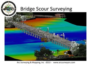
- 1. Bridge Scour Surveying Arc Surveying & Mapping, Inc -2013 - www.arcsurveyors.com
- 2. DOT Scour Evaluation Philosophy & Concepts for Existing Bridges “2.5.1 Overview FHWA-HIF-12-003” 4/2012 “There are many bridges in the United States that were not designed to withstand the effects of scour at foundations. These bridges may or may not be in jeopardy of failing if they experience a flood. In addition, there are significant numbers of bridges that are located on a reach of stream where the channel geometry has changed or the channel has migrated away from the location where it was designed and constructed. There are also significant numbers of bridges in existence whose foundation types are unknown, which makes it nearly impossible to assess their vulnerability to scour unless further actions are taken.”
- 3. Bathymetric & Structure Surveys Arc has developed surveying and mapping techniques that describe underwater surfaces at bridge foundations utilizing: 1. Multibeam Bathymetry (Below water Survey) 2. Terrestrial Laser Scanning (Above water survey) 3. DOT Construction or As-Built Plans (Incorporate Design data) 4. 3D models (Combine Bathymetry, topography , DOT drawings 5. Large scale interactive 3D models 6. Subterranean Foundations and pile data (Add to models and maps) 7. Side-scan, magnetometer and sonar scanning technology (Locating cables, pipelines, debris, etc on the seafloor) 8.Baseline, Condition and Isopachs that determine seafloor changes 9.Specialized equipment 10. Data access (From Arc Server, view on computers and Mobile devices)
- 4. Example Bridge Survey Sisters Creek Bridge, Jacksonville, Florida Arc Surveying & Mapping, Inc has surveyed hundreds of bridges throughout the State of Florida. All surveys are performed under the direct supervision of a Registered Professional Land Surveyor and Certified Hydrographer. Surveys conform to Federal, State and local regulations.
- 5. 1. Multibeam Swath Bathymetry Bridge surveys are performed utilizing a new generation of high definition multibeam swath sounders providing unparalleled accuracy and detail of the interface of the seafloor with underwater structures . Bridge scour detection and monitoring has never been better. Multibeam bathymetric elevations in NAVD88 are color coded - red designating the shallowest elevation and dark blue designating the deepest.
- 6. 2. Terrestrial Laser Scan Survey The above water bridge structure is surveyed utilizing a broad terrestrial laser scanner sweep. The scanner sweep is obtained for bridge structure location and is merged with bathymetry.
- 7. 3. DOT Construction Drawings DOT construction or as-built drawing information is incorporated into the survey computer model to verify the structure dimensions and foundation data , such as pile size and depth.
- 8. 4. 3D Bridge Models 3D Bridge models are comprised of topographic laser scan survey data obtained at low tide and multibeam swath hydrographic survey data obtained at high tide for survey overlap registration. Bridge structure data from DOT plans are merged to the laser scan and hydrographic model. Topographic Laser scan data (grey image) Multibeam Hydrographic Data Pile Data from DOT Drawings (green image)
- 9. 5. Large Scale Interactive Models This bridge survey model combining laser scanning, multibeam swath bathymetry and design data from DOT construction plans is interactive. Moving a cursor over the model provides coordinates, elevations, depths , heights, etc. Cross-sections and profiles may be imported into MicroStation or AutoCAD formats.
- 10. 6. Subterranean Pile Tip & Foundation Elevations Subterranean pile tip elevation and foundation data (unknown Structures) obtained from DOT Construction or As-built plans are incorporated into models and maps and are very helpful in bridge safety planning or during a scour event. Tip Elevations obtained from DOT drawings
- 11. 7. Side-Scan Sonar & Magnetometer Surveys Side-Scan Sonar Imagery identifying objects lying on the seafloor and magnetometer surveys identifying ferrous metals on and below the seafloor combined with bathymetry and topographic laser scanning provides the ultimate pre and post demolition survey assuring contractor compliance in leaving a navigation-hazard -free site.
- 12. Side-Scan Survey Close-up Side-scan sonar imagery which identifies objects lying on the seafloor are georeferenced to multibeam swath bathymetry . Coordinates and descriptions of objects are tabulated. Sonar images are captured and saved to maps.
- 13. 8. Baseline, Condition Surveys , Isopachs and Scour Monitoring 1. Perform a Baseline bathymetric survey 2. Perform a Condition bathymetric survey 3. Generate an Isopach measure sediment and movement.
- 14. Bathymetric Survey Isopach 2.1 ft Erosion 850 cys 1.0 ft Incretion Minimal Incretion Quantities of incretion and erosion are calculated using mass volume methods (digital terrain models - surface to surface) Baseline and Condition survey are overlayed – Elevation differences in surveys are illustrated on the isopach in feet of change eliminating comparison of maps.
- 15. Scour Profile Bridge Centerline Bridge Centerline Scour
- 16. Reson SeaBat 7125 Dual Frequency Multibeam Swath Sounder 100% seafloor coverage, 512 sonar beams, 150 degree swath , swath coverage 7 x depth, Dual Frequency 200 kHz and 400 kHz. POS/MV Wavemaster RTK/GPS - provides accurate corrections of position, attitude, heading, heave, pitch and roll motion compensation and is the latest state-of-the-art inertial GPS technology. Digibar Sound Velocity Profiler – measures water column speed of sound for depth calibration of sonar sounding devices. Blueview 3D Sonar Scanner – Surveys areas not accessible by boat. 360 degree swath from water surface to Seafloor. Ideal for bridge foundation and countermeasure protection surveys. Arc Surveying & Mapping, Inc owns and operates IHO Compliant equipment 9. Specialized Hydrographic Surveying Equipment Knudsen 320M Dual Frequency Singlebeam Depth Sounder operates from 24 kHz to 210 kHz – identifies firm bottom and fine sediments in suspension
- 17. Simultaneous Hydrographic and Topographic Surveys Arc Surveying & Mapping, Inc collects hydrographic and topographic data simultaneously utilizing a Reson 7125 multibeam swath sounder and a Riegl VZ 1000 terrestrial laser scanner. The resultant 3D interactive computer model provides 100% coverage of the survey area and allows the user the measure anywhere within the model.
- 18. Blueview Sonar Scan Surveys Through the use of new sonar technology, precise detail of underwater bridge structures is attainable, even in shallow water and limited access conditions. The Blueview sonar scanner can be lowered to the seafloor on tripod or moved from location to location by a diver.
- 19. Arc/BlueView 3D Under Bridge Surveys Arc understands the necessity for structure detail and debris location under bridges and has the surveying and computer processing expertise to merge detailed bridge foundation survey data with multibeam bathymetric and laser scanning data to provide a complete Survey model
- 20. BlueView Sonar Scans Arc/Blueview sonar scans under bridges and around structures are in sufficient detail to measure stone countermeasure quantities and are useful in viewing close-up detail of underwater structures. Sonar images are attached to maps for visual reference.
- 21. Bridge Survey Data Access https://maps.google.com/maps?hl=en&mid=1373380841 Access Bridge Survey Data on these devices (click on My Places) Arc Surveying & Mapping, Inc has developed a communication system by which authorized users may access bridge survey data from a variety of devices. It is anticipated access to this data will be beneficial in the event of emergencies.
- 22. All Bridge Surveys Performed are Available View Surveyed Bridges Select Bridge from Menu Select Required Data
- 23. Select Required Data Bathymetric Coverage Zoom To Current Depths Maps – PDFs - DGNs
- 24. Thank You for Viewing this presentation Combining experience, technology, innovation and quality with a goal of exceed Ing client expectations. Contact - John F. Sawyer jsawyer@arcsurveyors.com Arc Surveying & Mapping, Inc 904 384 8377 Visit our website www.arcsurveyors.com For More Information please contact