1. Why So Blue,
Crater Lake?
Here’s the story of an enormous volcano that blew its top, leaving behind one of the most beautiful,
other-worldly places on earth: Crater Lake National Park—home of the planet’s bluest water.
What Goes Up…
Rising roughly 12,000 feet above sea level,
Mount Mazama wasn’t the highest of the
Cascades volcanoes. Its peak fell slightly short of
Mount Shasta (to the south in California) and
Mount Ranier (to the north in Washington). But
in terms of pure mountainous girth, Mazama was
the undisputed heavyweight champion of the
Pacific Northwest. For more than 400,000 years,
the composite volcano grew layer by layer in spits
and spurts over the top of a giant subterranean
magma chamber in what is today southern Ore-
gon. Mild eruptions, lava flows, gassy vents, and
glaciation created a rugged landscape marked by
frequent change. The biggest change occurred just
7,700 years ago (a mere blip on the geologic time
scale). Mount Mazama erupted in spectacular
fashion. Ten cubic miles of ash and lava shot 30
miles into the sky.
Pyroclastic flows laid waste to entire pine
forests. One lava flow carved out 40 miles of what
later became the Rogue River. Ash covered the
ground as far away as Nebraska. The eruption
ranks as a VEI 7, or “super-colossal,” on the
USGS’s Volcanic Explosivity Index. (The scale
only goes up to 8.) Put into perspective, Mazama’s
eruption was 42 times stronger than Mount St.
Helens’ blowup in 1980. Geologists believe it to
be the most violent Cascades eruption of the past
million years.
…Must Come Down
Because Mount Mazama was so wide, after all the
lava emptied from the chamber, there was nothing
left to hold up the mountain. Result: Several
million tons of earth, rock, and ash collapsed into
the chamber. When the dust cleared, what had
been a mountain was now a mountain-sized hole.
The volcanic caldera formed a nearly perfect circle
six miles wide and 4,000 feet deep. Over the next
few centuries, the volcanic activity slowly subsid-
ed while the caldera steadily filled up with snow
and rain. Crater Lake was born.
246
2. Clash of the Titans
Because the eruption occurred so recently (in terms
of the earth’s history), there were witnesses. The
Klamath and Modoc Indians both lived nearby, and
the mountain blast shook them to the core. The
Klamaths’ name for Mazama was Moy-Yaina (“Big
Mountain”). The Indians, believing the lake to be
sacred ground, also kept its existence a secret from
white settlers. A group of gold prospectors finally
discovered the lake by accident in 1853. Struck by
its beauty, they spread the word to others. Before
long, curious adventurers made the harsh journey
through thick forests, across hardened lava fields,
and up the steep terrain to see it for themselves.
The Father of Crater Lake
One such adventurer was William Gladstone Steel,
who made it to the southwestern part of the rim
(called Discovery Point) in 1885. He was amazed:
All the ingenuity of nature seems to have
been exerted to the fullest capacity to build
one grand awe-inspiring temple the likes of
which the world has never seen before.
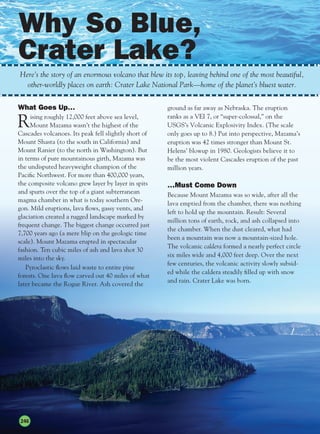
Rising from 1,000 to 2,000 feet above the
shore, the rim of Crater Lake offers incredible
views. The first sight to strike Steel (and most
visitors) was the crystal-clear blue water. It was
bluer than the sky. Across the lake, the vertical
cliffs of the rim were also colorful, marked by
towering castles of orange lava deposits, bright
yellow lichen, white speckles of snow, and forests
of evergreen trees. On a calm day glassy reflections
on the water create abstract patterns of the shore
six miles away.
Steel was also taken by Crater Lake’s other
prominent feature, a conical island that rises more
than 700 feet out of the southwestern portion of
the lake. It’s also covered with volcanic rock and
forests of pines, fir, and hemlock. Reminding Steel
of a sorcerer’s cap, he named it Wizard Island.
Over time, Steel named several more of Crater
Lake’s features, including Llao Rock and Skell
Head. And he was the one who called the
ex-mountain “Mazama,” the name of his
mountaineering club.
Garfield Peak
Wizard Island
Llao Rock
Caldera collapse Steam explosions Crater Lake todayEruption of
Mount Mazama
Crater Lake panorama,
with a view of Wizard Island
247
3. A Park is Born
Steel became Crater Lake’s biggest advocate. He
brought in tourists, scientists, surveyors, and devel-
opers. In 1886 he hired Clarence Dutton of the
United States Geological Survey to measure the
lake’s depth, who wrote:
As the visitor reaches the brink of the cliff,
he suddenly sees below him an expanse of
ultramarine blue of a richness and intensity
which he has probably never seen before, and
will not be likely to see again.
Steel and Dutton knew the lake was deep, but it
wasn’t until they lowered a piano wire at various
points along the surface that they grasped just how
deep: nearly 2,000 feet.
Steel was instrumental in convincing President
Theodore Roosevelt to designate the area as the
sixth U.S. national park in 1902. However, if Steel
had gotten his way, there would have been a lot of
development there: He wanted to build an elevator
to take visitors from the top of the rim to the
shore, and a bridge to Wizard Island. His colleagues
at the National Park Service wanted to keep the
area pristine, though, and Steel lasted only three
years as Crater Lake’s superintendent before he was
ousted. Today, there is minimal evidence of man’s
impact at the park.
A Lake Like No Other
Crater Lake wears its geologic past on its sleeves.
You can actually look at the inside of a sleeping
volcano. Here’s some of the science and superlatives
of the “Gem of the Cascades.”
• That’s deep. Modern sonar readings show that
Dutton was pretty close to the mark. The lowest
part of the lake bed is 1,949 feet beneath the
surface. That ranks Crater Lake as the deepest
lake in the United States, and the ninth deepest
on earth. If the Empire State Building were
lowered into the lake (not counting for water
displacement), by the time the ground floor
reached the bottom, the top of the spire would be
500 feet below the surface.
• A perfect balance. Most of the world’s lakes are
fed by streams and rivers, and drain into streams
and rivers. Crater Lake does neither. It is filled
solely by precipitation. (Average rainfall per year:
66 inches. Average snowfall: 44 feet.) The lake
loses its water through evaporation (and to a
lesser extent, by seepage into the porous rock).
These processes—precipitation and evaporation—
balance each other out so well at Crater Lake that
the surface rises and falls only by a few feet every
century. Plus, because of Crater Lake’s great depth,
the surface rarely freezes.
• I can see clearly now. Crater Lake contains
what may be the clearest, purest water known to
exist. In most lakes that boast clear water, you
can see about 16 feet below the surface in broad
daylight. But in Crater Lake, it’s possible to see
to depths of more than 100 feet. The deepest
scientific measurement has been 142 feet, a world
record. Several factors contribute to the lake’s
clarity: Because no rivers run into it, no silt gets
deposited. There’s little pollution because of
Crater Lake’s remoteness (the nearest big cities—
Portland, San Francisco, and Reno—are each
hundreds of miles away). There are also very few
organic materials or dissolved minerals in the
water, and the human impact around and on the
lake is minimal.
It costs the U.S. Treasury 1.73¢ to make and distribute a penny.
One of Uncle John’s writers frolicking on Wizard Island
248
4. • The blues. How can the water be so clear—
and so blue—at the same time? Actually, it’s so
blue because it’s so clear…and so deep. Here’s
how it works: As sunlight penetrates the lake,
it absorbs all the colors of visible light except
for blue, which it reflects back. The deeper and
clearer the water, the more blue gets reflected.
• New growth. Wizard Island is one of two new
volcanoes that have risen out of Mazama’s
caldera (the other is still underwater). At barely
6,000 years old, the island is very young, yet
many of the trees that grow on it are very old,
some more than 800 years.
• Phantom ship. Mazama’s demise unearthed
some very old rock formations, including Crater
Lake’s other island, Phantom Ship. This spire of
400,000-year-old andesite lava was left behind
by an ancient eruption. When viewed from the
rim, the island looks like an old sailing ship,
hence the name. The rocky spires rise 163 feet
above the surface; the island itself is about
300 feet long. Clinging to the rocks are an
astounding seven species of trees.
• Going down. There have been a few scientific
expeditions—manned and unmanned—to
see what lies at the bottom of Crater Lake.
Scientists have learned that the area is still
active—steam vents enter the water at great
depths. That allows primitive life-forms to exist
more than 1,000 feet below the surface, which
actually receives faint bits of sunlight on clear
days. But perhaps the biggest surprise came at
depths of 100 to 460 feet along the lake walls—
forests of moss several stories thick.
The Future of Crater Lake
Will the volcano erupt again? Most likely. The
constant change that shaped the region is still in
flux. What scientists don’t know is how much
magma—if any—still remains in the chamber, and
just how much pressure is building up. Future
activity is likely to happen just east of the lake,
where the geologic “hot spot” now lies. What’s
more worrisome is the chance of a large earthquake
causing landslides and huge waves on the surface.
A cataclysmic seismic event could rupture the rim
wall and cause the lake to drain, creating a flood of
4.6 trillion gallons of water. But for now, Mazama
remains at rest.
The average Canadian family size is 3.1 people...including 1.2 children.
Phantom Ship at Crater Lake
249