SlideShare ist ein Scribd-Unternehmen logo
1 von 8
Downloaden Sie, um offline zu lesen
A new strategy of
sustainable neighbourhood
planning: Five Principles
The Five Principles are:
1. 	 Adequate space for streets and an
efficient street network. The street
network should occupy at least 30 per cent of
the land and at least 18 km of street length
per km².
2. 	 High density. At least 15,000 people per
km², that is 150 people/ha or 61 people/acre.
3. 	 Mixed land-use. At least 40 per cent of floor
space should be allocated for economic use in
any neighbourhood.
4. 	 Social mix. The availability of houses in
different price ranges and tenures in any given
neighbourhood to accommodate different
incomes; 20 to 50 per cent of the residential
floor area should be for low cost housing; and
each tenure type should be not more than 50
per cent of the total.
5. 	 Limited land-use specialization. This is to
limit single function blocks or neighbourhoods;
single function blocks should cover less than
10 per cent of any neighbourhood.
In recent decades, the landscape of
cities has changed significantly because
of rapid urban population growth. A
major feature of fast growing cities
is urban sprawl, which drives the
occupation of large areas of land and is
usually accompanied by many serious
problems including inefficient land use,
high car dependency, low density and
high segregation of uses. Coupled with
land use speculation, current models of
city growth result in fragmented and
inefficient urban space where urban
advantage and city concept are lost.
Cities of the future should build a
different type of urban structure and
space, where city life thrives and the
most common problems of current
urbanization are addressed. UN-Habitat
proposes an approach that summarizes
and refines existing sustainable urban
planning theories to help build a new
and sustainable relationship between
urban dwellers and urban space, and to
increase the value of urban land. This
approach is based on 5 principles that
support the 3 key features of sustainable
neighbourhoods and cities: compact,
integrated, connected.
UN-Habitat supports countries to develop urban
planning methods and systems to address current
urbanization challenges such as population growth,
urban sprawl, poverty, inequality, pollution,
congestion, as well as urban biodiversity, urban
mobility and energy.
High density urban growth vs. urban sprawl
DISCUSSION NOTE 3
A compact city. Paris, France
© UN-Habitat/Laura Petrella
Urban sprawl. Uberlandia, Brazil
© UN-Habitat/Alessandro Scotti
URBAN PLANNING
URBAN PLANNING DISCUSSION NOTE 3
2
Objectives of the Five Principles
In supporting sustainable neighbourhoods, the Five Principles seek
to:
1.	 Promote high density urban growth, alleviate urban sprawl
and maximize land efficiency.
2.	 Promote sustainable, diversified, socially equal and thriving
communities in economically viable ways.
3.	 Encourage walkable neighbourhoods and reduce car
dependency.
4.	 Optimise use of land and provide an interconnected network
of streets which facilitate safe, efficient and pleasant walking,
cycling and driving.(1)
5.	 Foster local employment, local production and local
consumption.
6.	 Provide a variety of lot sizes and housing types to cater for the
diverse housing needs of the community, at densities which
can ultimately support the provision of local services.(2)
Key features of sustainable
neighbourhoods
The Five Principles promoted by UN-Habitat are meant to foster
sustainable urban development by creating livable and efficient
neighbourhoods. Sustainable cities are prosperous, convenient,
livable, and safe. A sustainable city would possess the following
key features, which the Five Principles contribute to:
1.	 A vibrant street life: Supporting and promoting street
life by enabling a variety of activities, conducive frontage
and street width, and reducing the presence and role of
private transport. The Five Principles encourage high density
and mixed land use which boost a lively street life. A high
population density generates sufficient industrial and
commercial service demand while mixed land use provides
adequate manufacturing and service space. Cities consistent
with the Five Principles are able to link demand with supply
and thus stimulate a prosperous city street life which satisfies
people’s material and spiritual needs and creates a safe and
vibrant city life. This is a key feature of sustainable cities.
2.	 Walkability: Promoting walkability as a key measure to
bring people into the public space, reduce congestion and
boost local economy and interactions. A vibrant street life
encourages people to walk or cycle around, while a rational
street network enables necessary city administrative services
to be offered within walking or cycling distance and ensures
security. High density, mixed land use and a social mix make
proximity to work, home and services possible. Walkability
helps to reduce automobile reliance and thus alleviate relevant
congestion, air pollution and resource depletion issues. It is
healthier to “walk more and drive less”! Pedestrians add an
incredible amount of vibrancy to city life.
3.	 Affordability: Supporting affordability of transactions and
economic activities, as well as of services and housing, by
promoting proximity and reducing costs and building services
for a diverse group of users. Proximity, brought about by
applying the Five Principles, helps to reduce wastage of
time and resources and thus brings down general service
costs. Furthermore, the social mix principle tries to promote
a rational distribution of urban public resources and provides
adequate housing for different revenue groups through city
planning regulations - ensuring social equity and promoting
economic efficiency. An affordable and accommodating city is
a core feature of a sustainable city.
Malian street, Beijing, China
© UN-Habitat/Jimin Zheng
Bute Street, Vancouver, Canada
© UN-Habitat/Shan Zheng
Five Principles of Sustainable Neighbourhood Planning
3
Principle 1
Adequate space for streets and an efficient street network
The street network should encompass at least 30 per cent of the land with at least 18 km of
street length per square kilometer.
Principle 1 aims to develop an adequate level of street network
that not only works for vehicles and public transport but also
specifically aims to attract pedestrians and cyclists.(3)
It will include
a street hierarchy with arterial routes and local streets based on
traffic speed differences. The street network will also shape the
urban structure which, in turn, sets the pattern of development
blocks, streets, buildings, open spaces and landscape.(4)
Principle 1
provides the material basis for sustainable urban development.
To design the street network in a high density city, the amount
of land needed for roads and parking needs to be determined.
According to research on urban impervious surface coverage
(Figure 1), complex functions and high population density require
high street coverage. The research indicates that 20-30 per cent
of urban land and 40-60 per cent of commercial centre land is
used for roads and parking. In high density mixed-use urban
areas, it is recommended that at least 30 per cent of land is
allocated for roads and parking, and at least 15-20 per cent is
allocated for open public space.
Figure 1: Surface coverage (Arnold and Gibbons 1996) (5)
transport catchment is another important factor in designing a
street hierarchy. (See Figure 2).
Figure 2: Catchment areas for several transport forms
Stop interval Corridor width
area served
Catchment per
stop
Minibus 200M 800M 320-640
Bus 200M 800M 480-1,760
Guided Bus 300M 800M 1,680-3,120
Light Rail 600M 1,000M 4,800-9,000
Rail 1,000M+ 2,000M+ 24,000+
Source: Urban Design Compendium (ww2.newham.gov.uk/Documents/UDC.pdf)
Combining walkability and public transport catchment, the
suggested distance between two arterial routes is between 800 to
1,000 m. This distance is the constraint for the street grid design,
urban structure design and neighbourhood size.
To help explain the reason for the 18 km street length per square
kilometre, Figure 3 shows a simple street network model. In an
area of one square kilometre, nine vertical and nine horizontal
streets are designed to form a street network. The distance
between two adjacent streets is 111 m, and the total street length
is 18 km. In this street network model, both street hierarchy and
block size are considered. This simple model demonstrates the
balance between street and other land uses. City management
and urban planners could “adjust” the design pattern of the
street network, but a street density level similar to the one
recommended in the model should be maintained.
Figure 3: Street network model design
To develop sustainable mobility, the design of the street network
should differ from the modernist practice in the following aspects:
•	 Streets are walkable and cyclist friendly
•	 Public transport is encouraged
•	 Road hierarchy is highly interconnected
•	 Sufficient parking space is provided
These characteristics should be reflected in the street design and
construction.
Walkability in a neighbourhood can be measured by the walking
distance to key services; this is usually from 400 to 450 m. Public
Principle 1
encourages
efficient traffic,
sustainable
accessibility,
social
interaction,
public safety
and access to
amenities.
60%
50%
40%
30%
20%
10%
0
Effective
Coverage
High
Density
Residential
Multifamily
Commercial
Low
Density
Residential
Streets
Sidewalks
Parking/Driveways
Roofs
Lawns/Landscaping
URBAN PLANNING DISCUSSION NOTE 3
4
Principle 2
High density
At least 15,000 people per km²; that is, 150 people/ha or 61 people/acre.
Principle 2 addresses population growth and is a direct response
to the global population explosion and rapid urbanization. To
prevent urban sprawl and promote sustainable urban extension,
it is necessary to achieve high density, which is the foundation of
a sustainable neighbourhood. High density essentially means a
concentration of people and their activities. Figure 4 below shows
the density of the built-up area of some select cities.
Figure 4: 16 cities listed by population density
Rank City / urban
area
Country Population Built up
area (in
km²)
Built
up area
density
(people
per km²)
1 Dhaka Bangladesh 9,196,964 165.63 55,530
2 Hong Kong China 5,179,089 97.63 53,050
3 Mumbai India 16,161,758 370.90 43,570
4 Rajshahi Bangladesh 599,525 20.26 29,590
5 Milano Italy 3,708,980 635.17 27,380
6 Casablanca Morocco 3,004,505 114.31 26,280
7 Cairo Egypt 13,083,621 569.17 22,990
8 Seoul Korea,
Republic of
14,546,082 706.14 20,600
9 Ho Chi Minh City Vietnam 4,309,449 210.33 20,490
10 Singapore Singapore 4,309,797 245.24 17,570
11 Mexico City Mexico 17,224,096 1,058.53 16,270
12 Santiago Chile 5,337,512 438.51 12,170
13 Bangkok Thailand 9,761,697 1,025.93 9,510
14 Beijing China 11,866,211 1,576.38 7,530
15 Paris France 9,519,527 1,482.08 6,420
16 Castellon Spain 268,712 82.03 3,280
Source: A Global Sample of 120 Cities, 1990-2000 (http://www.lincolninst.edu/
subcenters/atlas-urban-expansion/global-sample-cities.aspx)
Figure 4 shows that high density is a feature of cities at different
development levels and contexts. According to the same source, in
2000, cities in developing countries had an average built-up area
density of 129 p/ha.(6)
To promote a high population density and
stop the downward trend worldwide, Principle 2 defines a minimum
of 150 p/ha for a sustainable neighbourhood – which is feasible,
though slightly above the average density mentioned above. Cities
in land rich or developed countries, however, may set a lower target
and work progressively towards increased density.
Compared with low density, high density has economic, social and
environmental benefits as follows:
•	 Efficient land use slows down urban sprawl because high density
neighbourhoods can accommodate more people per area.
•	 Reduced public service costs. High density neighbourhoods
tend to decrease the costs of public services such as police
and emergency response, school transport, roads, water and
sewage, etc.(7)
•	 Support for better community service.
•	 Reduced car dependency and parking demand, and increased
support for public transport.
•	 Provision of social equity.
•	 Support for better public open space.
•	 Increased energy efficiency and decreased pollution.
People may worry about the perceived connection between
density and social problems, such as crime, poverty and
depression, but studies show no such correlation when
factors such as income are accounted for.(8)
A well-designed
and organized high density neighbourhood can be safe and
comfortable, but a good quality design is essential to achieve
viable high density areas.
In the context of fast urbanization, high density is a smart choice
and is at the core of sustainable urban planning.
Site area (hectares) 12.48
Parking (space per unit) 0.5
Tenure Private 843
Social rented 940
Density (Dph) 142
Density (Hrh) 557
High density neighbourhood - Churchill Gardens, London, England.(9)
© Greater London Authority. Used with Permission.
Note: 	 Dph-Dwellings per hectare
	 Hrh- Habitable rooms per hectare
Location: Churchill Garden, London
Density, parking and site area:
Five Principles of Sustainable Neighbourhood Planning
5
Principle 3
Mixed land-use
At least 40 per cent of the floor space is allocated for economic use in any neighbourhood.
Principle 3 is aimed at developing a range of compatible activities
and land uses close together in appropriate locations and flexible
enough to adapt over time to the changing market. The purpose
of mixed land-use is to create local jobs, promote the local
economy, reduce car dependency, encourage pedestrian and
cyclist traffic, reduce landscape fragmentation, provide closer
public services and support mixed communities. Mixed land-use
can be applied at different spatial levels: city, neighbourhoods,
blocks and buildings. Principle 3 focuses on the neighbourhood
and block level.
At the end of the nineteenth century, with the introduction of
modern urban planning concepts, the land-use zoning approach
was applied and single function areas came into existence in
cities all over the world. The adoption of single-use zoning
strategies has resulted in serious problems for cities. Urban sprawl
has increased, the quality and vitality of many urban centres
has declined, and car dependence and traffic congestion affect
everyone. To solve these problems, new urbanism promoted
the core concept of mixed land-use. Mixed land-use requires
some combination of residential, commercial, industrial, office,
or other land-use. When different functions are mixed in one
neighbourhood, economic and residential activities should
be made compatible and well balanced by careful design and
management.
The compatibility of different land uses depends mainly on
the noise and pollution levels. A careful study on land use
compatibility should be carried out to protect the community
wellbeing and area livability.
According to research done in the 1950s on land use in Central
Business Districts (CBD), 68 per cent is the optimum floor area
allocation for economic uses, 22 per cent for residential use and
10 per cent for public service use.(10)
Figure 5 gives a summary of
floor area allocation in several CBDs.
Figure 5: Allocation of floor area in five CBDs.
Beijing
Chao
yang
CBD
Shang
hai
Lujiazui
CBD
Shen
zhen
CBD
Paris la
Defense
CBD
Tokyo’s
Water-
front
Subcen-
tre
Area (km2
) 4.02 1.7 4.13 1.6 4.48
Total floor
areas
Mm² 10.72 4 7.8 3.5 7
% 100 100 100 100 100
Economic
uses floor
areas
Mm² 7.19 3.27 4.8 2.9 3.8
% 67 81 62 82 55
Public ser-
vice floor
areas
Mm² 0.55 0.43 100 6 1.15
% 5 11 13 2 16
Residential
floor areas
Mm² 2.97 0.3 200 54 2.05
% 28 8 25 16 29
Source: CBD规划策划重点分析研究
http://wenku.baidu.com view/1c07d5630b1c59eef8c7b42f.html
Note : Mm²- Million square metres
However, if too little area is for residential use, the CBD or
neighbourhood will decline. For example, in the 1990s, the inner
city of Los Angeles was on the wane. By applying a mixed-use
concept to reform the city, people were drawn back to the city
centre. In 1998, downtown Los Angeles was home to around
18,000 people, now, it houses nearly 50,000 residents. (11)
Downtown Los Angeles has shifted from a 9 to 5 CBD to a 24-7
prosperous neighbourhood.
Based on the above research and analysis on CBDs, the suggested
floor area distribution for a sustainable neighbourhood is: 40 to 60
per cent for economic use, 30 to 50 per cent for residential use and
10 per cent for public services. The set of recommended standards is
a range to allow for flexibility so that different cities can adapt them
to their own situations. Mixed land-use is an inherent part of the
nature of cities and is a pillar of sustainable urban development.
High density mixed-use neighbourhood - Addison Circle, Addison, Texas, United States.(12)
© Town of Addison. Used with permission
Land size 501,800 m²
Residential floor area 436,600 m²
Dwelling 4,800 Units
Density 95 Du/Ha
Economic use floor area 557,400 m²
URBAN PLANNING DISCUSSION NOTE 3
6
Principle 4
Social mix
The availability of houses in different price ranges and tenure types in any given neighbourhood to
accommodate different incomes; 20 to 50 per cent of the residential floor area is distributed to low cost
housing, and each tenure type should be no more than 50 per cent of the total.
Principle 4 aims to promote the cohesion of and interaction
between different social classes in the same community and to
ensure accessibility to equitable urban opportunities by providing
different types of housing. Social mix provides the basis for healthy
social networks, which, in turn are the driving force of city life.
Social mix and mixed land-use are interdependent and promote
each other. Mixed land-use and appropriate policy guidance
lead to social mixing. In a mixed land-use neighbourhood,
job opportunities are generated for residents from different
backgrounds and with different income levels. People live and
work in the same neighbourhood and form a diverse social
network. Social mix is a socio-spatial concept, with the following
objectives:
•	 to promote more social interaction and social cohesion across
groups;
•	 to generate job opportunities;
•	 to overcome place-based stigma;
•	 to attract additional services to the neighbourhood;
•	 to sustain renewal/regeneration initiatives; (13)
Although social mix is a socio-spatial concept that is difficult to
analyse quantitatively, it is still possible to set a numerical standard
from the empirical evidence based on good practice in Europe.
In Holland, areas regulated by the VINEX policy are earmarked
for new housing, 30 per cent of which must be affordable. In
Ireland, new “set aside” policies stipulate that 20 per cent of
all new development must be set aside for affordable housing
(inclusionary zoning). In the United Kingdom, the system is known
as planning gain and the thresholds for affordable housing are
normally set at around 25 per cent of new development, with
the exception of London where the percentage is being raised
to between 30 and 50 per cent.(14)
After analyzing the above
information, it is recommended that between 20 and 50 per cent
of the residential floor area is allocated to affordable housing,
and one single tenure type should not exceed 50 per cent of the
residential floor area. The recommendation has a wide range
to enable urban planners and city management to follow the
national or regional owned-to-rented ratio. When implementing
this recommendation, market factors should not be overlooked.
To ensure the smooth implementation of the above criteria
and achieve social mix there are many possible policy options.
Depending on their social and economic development stage, cities
should select proper policies to create a package that promotes a
balanced, developed local community. Possible policies include:
•	 promoting social mix by mixing tenures and developing sales
programmes within public estates;
•	 achieving social mix through allocation policies and the spatial
distribution of poor households.;
•	 investing in and improving public housing;
•	 achieving social mix by urban and housing design;
•	 promoting multi-level employment within the community;
•	 working with private developers to increase public housing
supply;(15)
•	 providing plots in different sizes and with different
regulations, to increase the diversity of housing options.
Social mix is not an urban planning panacea for social problems
such as poverty and social segregation, but it can contribute
significantly to their solution. Combined urban planning
approaches are needed to tackle these urban challenges. This
social mix principle is not a short-term concept, but should be
applied with caution and over time.
Social mix neighbourhood
- Greenwich Millennium
Village, London, England.(16)
© Source: Google Maps
Note:	 Dph-Dwellings per hectare, Hrh- Habitable rooms per hectare
Location: Greenwich Peninsula, London.
Density, parking and site area:
Phase 1 2 3 4 Total
Site area (hectares) 2.44 4.72 3.17 4.86 15.19
Parking (space per unit) 0.93 1.10 0.83 1.24 1.03
Tenure Private 444 354 424 335 1557
Affordable 43 85 81 276 485
Density (Dph) 199 93 159 126 134
Density (Hrh) 579 276 454 371 371
Five Principles of Sustainable Neighbourhood Planning
7
Principle 5
Limited land-use specialization
To limit single function blocks or neighbourhoods; single function blocks
should cover less than 10 per cent of any neighbourhood.
Principle 5 aims at adjusting/limiting the use of functional zoning
to implement mixed land-use policies. Zoning is a land use
planning device used by local governments and urban planners
in many countries. Zoning may be use-based (regulating the uses
to which land may be put), or it may regulate building height, lot
coverage and similar characteristics or a combination of these.(16)
This principle focuses on the land-use aspect.
At the city level, the unilateral application of land-use
specialization creates many single-function neighbourhoods,
which is the source of contemporary urban challenges including
city congestion, segregation, car dependency, etc. Limiting land-
use specialization is important to create mixed land-use. There are
two ways to adjust zoning policies and apply Principle 5:
•	 to combine compatible land-uses into one block and
neighbourhood;
•	 to introduce mixed land-use zoning while respecting market
demand and cities’ urban by-laws and regulations.
In the process of implementing Principle 5, adjusting the zoning
policy according to the needs is important. To further illustrate
how to implement limited land-use specialization, the example
of the Canadian city of Vancouver’s Burrard Slopes IC Districts is
shown below.
Burrard Slopes IC Districts, an area of 0.55 km², was created
in the 1990s as an industrial-only area. The zoning policies of
Burrard Slopes have been adjusted several times since 1993 and
the area is now an industrial, commercial, residential and mixed-
use zone. In this district, economic and residential land-use is well
balanced by careful design and management. Service and light
industrial jobs have increased; residential development projects
have been introduced and population density and activities are
growing. A single function neighbourhood has been converted
into a vibrant multi-functional community.
Burrard Slopes IC Districts’ successful experience illustrates the
implementation of Principle 5 by adjusting the zoning code.
Reforming a single-function zoned neighbourhood is not only a
challenge but is also an opportunity for local governments and
urban planners.
Principle 5 is an urban planning tool to ensure the implementation
of mixed land-use and to increase economic diversity.
Industrial, Commercial, Residential and Mixed Use Zones, Burrard Slopes, City of Vancouver, British Columbia, Canada
Source: Google Maps Source: Burrard Slopes IC Districts Interim
Policies 1996
Source: City of Vancouver Zoning map,
2006
Industrial Commercial Mixed Use Zones, Burrard Slopes, City of Vancouver, British Columbia, Canada:
Key milestones: Burrard Slopes IC Districts Interim Policies; Adopted by City Council 24 June, 1993; Amended 21 April, 1994, 23 July, 1996 and 10
September, 1996; Burrard Slopes IC Districts Interim Rezoning Policies and Guidelines; Adopted by City Council on 29 November, 2007; Amended
19 January, 2010
URBAN PLANNING DISCUSSION NOTE 3
8
Application of the Five Principles
The Five Principles can be applied in the following contexts:
1.	 Fast growing cities - the Five Principles can be applied to help
cities that have to provide land, infrastructure and public
services for a fast-growing population resulting from: natural
growth; rural immigrants seeking employment; or even
internally displaced people fleeing conflict or disaster.
2.	 New urban settlements and urban extensions - the Five
Principles can be applied in new urban areas to avoid
repeating past mistakes.
3.	 Urban renewal and renaissance - declining cities can apply
the Five Principles for revitalization and urban transformation
initiatives.
4.	 Urban densification - growing cities that have no land for
further extension can use the Five Principles to achieve a
smoother densification process.
Status analysis: Neighbourhood
profiling	
The Five Principles provide a set of quantitative measurements
that can be used to analyze a neighbourhood. Figure 6 gives the
recommended ranges of quantitative measurements (in green).
City or neighbourhood statistical data can be plotted on this
chart, and the development status of that area can be visualized.
The chart, combined with more traditional criteria of sustainability,
may allow stakeholders to assess a neighbourhood and may point
to possible actions to improve the neighbourhood profile or to
support public discussion on the same.
Figure 6: Sustainability analysis of a neighbourhood
To help to apply these principles and help the public to
understand them, the Five Principles are explained in clear
language with a series of numerical standards proposed as a
reference point. The principles do not represent a comprehensive
theory and only cover some basic characteristics of sustainable
urban planning. The public can use them to make a quick and
intuitive judgment on whether a community possesses the
capacity for sustainable development. The Five Principles can also
help to draft future urban scenarios and urban plans.
Final Considerations
The Five Principles are highly interrelated and support each
other. High density provides the population and activity basis
for a sustainable neighbourhood; adequate street density is the
material basis; mixed land-use and social mix shape the land-
use and social life in the neighbourhood; and limited land use
specialization is the first step towards mixed neighbourhoods.
The Five Principles balance population growth, economic growth,
rapid urbanization, sustainable urban development and other
factors, and try to establish a new urban system. In this system,
population and urban infrastructure accomplish economies of
scale; diversified social networks and the diversity of land-uses
support each other and develop together; and urban space and
urban dwellers live and develop in harmony.
Besides good planning and design decisions, the application
of these principles also require supporting legal frameworks,
an analysis of the local society and economy, appropriate
infrastructure technology and capacity, and the institutional
capacity to enforce decisions.
Percentage
Formula Unit Principle
Street land-use
Total floor area
(30-45%) Principle 1
Population density (15-60 k people/km2
) Principle 2
Economic floor area
Total floor area
(40-60%)
Principle 3
Residential floor area
Total floor area
(30-50%)
Single tenure
Residential floor area
(0-50%)
Principle 4
Affordable housing
Residential floor area
(20-50%)
Single function block area
Neighbourhood area
(0-10%) Principle 5
0 10 20 30 40 50 60 70 80 90 100
UN-Habitat (United Nations Human Settlements Programme)
Urban Planning and Design Branch
P.O.BOX30030 Nairobi 00100 Kenya
Tel: +254 20 7623706
updb@unhabitat.org
www.unhabitat.org
Jan
2015
Footnotes: Details of the references in this Discussion Note can be found
on the electronic version at http://www.unhabitat.org/pmss/listItemDetails.
aspx?publicationID=3518

Weitere ähnliche Inhalte

Ähnlich wie sustainable neighbourhood.pdf

Reclaiming city streets for people.pdf
Reclaiming city streets for people.pdfReclaiming city streets for people.pdf
Reclaiming city streets for people.pdfLobna2010
 
Compact city
Compact cityCompact city
Compact cityCoEP
 
compact cities vs. urban sprawl
compact cities vs. urban sprawlcompact cities vs. urban sprawl
compact cities vs. urban sprawlGCUF
 
IRJET- A Review Study on Compact City
IRJET-  	  A Review Study on Compact CityIRJET-  	  A Review Study on Compact City
IRJET- A Review Study on Compact CityIRJET Journal
 
Report on sustainable urban travel bw
Report on sustainable urban travel bwReport on sustainable urban travel bw
Report on sustainable urban travel bwGargee Ghosh
 
The Streets in a Livable City
The Streets in a Livable CityThe Streets in a Livable City
The Streets in a Livable Citydrboon
 
Transport Policies for Van Couver, Canada
Transport Policies for Van Couver, CanadaTransport Policies for Van Couver, Canada
Transport Policies for Van Couver, CanadaSaumya Gupta
 
Walking ...
Walking ...Walking ...
Walking ...vlastos
 
Lesson 2 Why Sprawl Matters.pptx
Lesson 2 Why Sprawl Matters.pptxLesson 2 Why Sprawl Matters.pptx
Lesson 2 Why Sprawl Matters.pptxssuserc1ed5e
 
helixator- economic and social effects
helixator- economic and social effectshelixator- economic and social effects
helixator- economic and social effectsGuy Ronen
 
UNLOCKING POTENTIAL OF URBAN LAND SPACE: BUILDING OVER RIGHT OF WAYS
UNLOCKING POTENTIAL OF URBAN LAND SPACE: BUILDING OVER RIGHT OF WAYSUNLOCKING POTENTIAL OF URBAN LAND SPACE: BUILDING OVER RIGHT OF WAYS
UNLOCKING POTENTIAL OF URBAN LAND SPACE: BUILDING OVER RIGHT OF WAYSanuarhab
 
Designing Harmonious and Smart Cities
Designing Harmonious  and Smart CitiesDesigning Harmonious  and Smart Cities
Designing Harmonious and Smart CitiesJIT KUMAR GUPTA
 
2 urban and spatial plannning and design
2 urban and spatial plannning and design2 urban and spatial plannning and design
2 urban and spatial plannning and designTatang Kurniawan
 
Designing Harmonious and Smart Cities
Designing Harmonious and Smart Cities  Designing Harmonious and Smart Cities
Designing Harmonious and Smart Cities JIT KUMAR GUPTA
 

Ähnlich wie sustainable neighbourhood.pdf (20)

Reclaiming city streets for people.pdf
Reclaiming city streets for people.pdfReclaiming city streets for people.pdf
Reclaiming city streets for people.pdf
 
Compact city
Compact cityCompact city
Compact city
 
Amalan terbaik di Eropah
Amalan terbaik di EropahAmalan terbaik di Eropah
Amalan terbaik di Eropah
 
compact cities vs. urban sprawl
compact cities vs. urban sprawlcompact cities vs. urban sprawl
compact cities vs. urban sprawl
 
IRJET- A Review Study on Compact City
IRJET-  	  A Review Study on Compact CityIRJET-  	  A Review Study on Compact City
IRJET- A Review Study on Compact City
 
Report on sustainable urban travel bw
Report on sustainable urban travel bwReport on sustainable urban travel bw
Report on sustainable urban travel bw
 
The Streets in a Livable City
The Streets in a Livable CityThe Streets in a Livable City
The Streets in a Livable City
 
Brun Reaaa Paper
Brun Reaaa PaperBrun Reaaa Paper
Brun Reaaa Paper
 
Transport Policies for Van Couver, Canada
Transport Policies for Van Couver, CanadaTransport Policies for Van Couver, Canada
Transport Policies for Van Couver, Canada
 
Walking ...
Walking ...Walking ...
Walking ...
 
ChettaAlwaysWins
ChettaAlwaysWinsChettaAlwaysWins
ChettaAlwaysWins
 
Lesson 2 Why Sprawl Matters.pptx
Lesson 2 Why Sprawl Matters.pptxLesson 2 Why Sprawl Matters.pptx
Lesson 2 Why Sprawl Matters.pptx
 
helixator- economic and social effects
helixator- economic and social effectshelixator- economic and social effects
helixator- economic and social effects
 
UNLOCKING POTENTIAL OF URBAN LAND SPACE: BUILDING OVER RIGHT OF WAYS
UNLOCKING POTENTIAL OF URBAN LAND SPACE: BUILDING OVER RIGHT OF WAYSUNLOCKING POTENTIAL OF URBAN LAND SPACE: BUILDING OVER RIGHT OF WAYS
UNLOCKING POTENTIAL OF URBAN LAND SPACE: BUILDING OVER RIGHT OF WAYS
 
New Urbanism 1.pdf
New Urbanism 1.pdfNew Urbanism 1.pdf
New Urbanism 1.pdf
 
Designing Harmonious and Smart Cities
Designing Harmonious  and Smart CitiesDesigning Harmonious  and Smart Cities
Designing Harmonious and Smart Cities
 
Street appeal
Street appealStreet appeal
Street appeal
 
2 urban and spatial plannning and design
2 urban and spatial plannning and design2 urban and spatial plannning and design
2 urban and spatial plannning and design
 
Erreichbarkeit in Städten
Erreichbarkeit in Städten Erreichbarkeit in Städten
Erreichbarkeit in Städten
 
Designing Harmonious and Smart Cities
Designing Harmonious and Smart Cities  Designing Harmonious and Smart Cities
Designing Harmonious and Smart Cities
 

Mehr von Hamza Deeb

2-Manual Design .pdf
2-Manual Design .pdf2-Manual Design .pdf
2-Manual Design .pdfHamza Deeb
 
Projected_impacts_of_land_use_and_road_n.pdf
Projected_impacts_of_land_use_and_road_n.pdfProjected_impacts_of_land_use_and_road_n.pdf
Projected_impacts_of_land_use_and_road_n.pdfHamza Deeb
 
حقيبة الشركات المساهمة.pdf
حقيبة الشركات المساهمة.pdfحقيبة الشركات المساهمة.pdf
حقيبة الشركات المساهمة.pdfHamza Deeb
 
دليل الادوية في شهر رمضان.pdf
دليل الادوية في شهر رمضان.pdfدليل الادوية في شهر رمضان.pdf
دليل الادوية في شهر رمضان.pdfHamza Deeb
 
خطة التدريب.pdf
خطة التدريب.pdfخطة التدريب.pdf
خطة التدريب.pdfHamza Deeb
 
النشرة.pdf
النشرة.pdfالنشرة.pdf
النشرة.pdfHamza Deeb
 
نتائج تقييم منصات ريادة الأعمال.pdf
نتائج تقييم منصات ريادة الأعمال.pdfنتائج تقييم منصات ريادة الأعمال.pdf
نتائج تقييم منصات ريادة الأعمال.pdfHamza Deeb
 
cc-profile.en.pdf
cc-profile.en.pdfcc-profile.en.pdf
cc-profile.en.pdfHamza Deeb
 
Program Overview.pdf
Program Overview.pdfProgram Overview.pdf
Program Overview.pdfHamza Deeb
 
lmsh_ltswyry_0.pdf
lmsh_ltswyry_0.pdflmsh_ltswyry_0.pdf
lmsh_ltswyry_0.pdfHamza Deeb
 
دليلك للمقابلات الشخصية.pdf
دليلك للمقابلات الشخصية.pdfدليلك للمقابلات الشخصية.pdf
دليلك للمقابلات الشخصية.pdfHamza Deeb
 
1. Soil Classification.pdf
1. Soil Classification.pdf1. Soil Classification.pdf
1. Soil Classification.pdfHamza Deeb
 
#خليك_في_البيت واستثمر وقتك.pdf
#خليك_في_البيت واستثمر وقتك.pdf#خليك_في_البيت واستثمر وقتك.pdf
#خليك_في_البيت واستثمر وقتك.pdfHamza Deeb
 
idoc.pub_cswip-exam-questionpdf.pdf
idoc.pub_cswip-exam-questionpdf.pdfidoc.pub_cswip-exam-questionpdf.pdf
idoc.pub_cswip-exam-questionpdf.pdfHamza Deeb
 
range-hbeams.pdf
range-hbeams.pdfrange-hbeams.pdf
range-hbeams.pdfHamza Deeb
 
Y20_Communique.pdf
Y20_Communique.pdfY20_Communique.pdf
Y20_Communique.pdfHamza Deeb
 
Springer Ebooks.pdf
Springer Ebooks.pdfSpringer Ebooks.pdf
Springer Ebooks.pdfHamza Deeb
 
Spending_Habits_June_2020.pdf
Spending_Habits_June_2020.pdfSpending_Habits_June_2020.pdf
Spending_Habits_June_2020.pdfHamza Deeb
 

Mehr von Hamza Deeb (20)

2-Manual Design .pdf
2-Manual Design .pdf2-Manual Design .pdf
2-Manual Design .pdf
 
Projected_impacts_of_land_use_and_road_n.pdf
Projected_impacts_of_land_use_and_road_n.pdfProjected_impacts_of_land_use_and_road_n.pdf
Projected_impacts_of_land_use_and_road_n.pdf
 
حقيبة الشركات المساهمة.pdf
حقيبة الشركات المساهمة.pdfحقيبة الشركات المساهمة.pdf
حقيبة الشركات المساهمة.pdf
 
دليل الادوية في شهر رمضان.pdf
دليل الادوية في شهر رمضان.pdfدليل الادوية في شهر رمضان.pdf
دليل الادوية في شهر رمضان.pdf
 
35277801.ppt
35277801.ppt35277801.ppt
35277801.ppt
 
7.pdf
7.pdf7.pdf
7.pdf
 
خطة التدريب.pdf
خطة التدريب.pdfخطة التدريب.pdf
خطة التدريب.pdf
 
النشرة.pdf
النشرة.pdfالنشرة.pdf
النشرة.pdf
 
نتائج تقييم منصات ريادة الأعمال.pdf
نتائج تقييم منصات ريادة الأعمال.pdfنتائج تقييم منصات ريادة الأعمال.pdf
نتائج تقييم منصات ريادة الأعمال.pdf
 
cc-profile.en.pdf
cc-profile.en.pdfcc-profile.en.pdf
cc-profile.en.pdf
 
Program Overview.pdf
Program Overview.pdfProgram Overview.pdf
Program Overview.pdf
 
lmsh_ltswyry_0.pdf
lmsh_ltswyry_0.pdflmsh_ltswyry_0.pdf
lmsh_ltswyry_0.pdf
 
دليلك للمقابلات الشخصية.pdf
دليلك للمقابلات الشخصية.pdfدليلك للمقابلات الشخصية.pdf
دليلك للمقابلات الشخصية.pdf
 
1. Soil Classification.pdf
1. Soil Classification.pdf1. Soil Classification.pdf
1. Soil Classification.pdf
 
#خليك_في_البيت واستثمر وقتك.pdf
#خليك_في_البيت واستثمر وقتك.pdf#خليك_في_البيت واستثمر وقتك.pdf
#خليك_في_البيت واستثمر وقتك.pdf
 
idoc.pub_cswip-exam-questionpdf.pdf
idoc.pub_cswip-exam-questionpdf.pdfidoc.pub_cswip-exam-questionpdf.pdf
idoc.pub_cswip-exam-questionpdf.pdf
 
range-hbeams.pdf
range-hbeams.pdfrange-hbeams.pdf
range-hbeams.pdf
 
Y20_Communique.pdf
Y20_Communique.pdfY20_Communique.pdf
Y20_Communique.pdf
 
Springer Ebooks.pdf
Springer Ebooks.pdfSpringer Ebooks.pdf
Springer Ebooks.pdf
 
Spending_Habits_June_2020.pdf
Spending_Habits_June_2020.pdfSpending_Habits_June_2020.pdf
Spending_Habits_June_2020.pdf
 

Kürzlich hochgeladen

PAG-UNLAD NG EKONOMIYA na dapat isaalang alang sa pag-aaral.
PAG-UNLAD NG EKONOMIYA na dapat isaalang alang sa pag-aaral.PAG-UNLAD NG EKONOMIYA na dapat isaalang alang sa pag-aaral.
PAG-UNLAD NG EKONOMIYA na dapat isaalang alang sa pag-aaral.KathleenAnnCordero2
 
Call Girls In Aerocity 🤳 Call Us +919599264170
Call Girls In Aerocity 🤳 Call Us +919599264170Call Girls In Aerocity 🤳 Call Us +919599264170
Call Girls In Aerocity 🤳 Call Us +919599264170Escort Service
 
Dutch Power - 26 maart 2024 - Henk Kras - Circular Plastics
Dutch Power - 26 maart 2024 - Henk Kras - Circular PlasticsDutch Power - 26 maart 2024 - Henk Kras - Circular Plastics
Dutch Power - 26 maart 2024 - Henk Kras - Circular PlasticsDutch Power
 
THE COUNTRY WHO SOLVED THE WORLD_HOW CHINA LAUNCHED THE CIVILIZATION REVOLUTI...
THE COUNTRY WHO SOLVED THE WORLD_HOW CHINA LAUNCHED THE CIVILIZATION REVOLUTI...THE COUNTRY WHO SOLVED THE WORLD_HOW CHINA LAUNCHED THE CIVILIZATION REVOLUTI...
THE COUNTRY WHO SOLVED THE WORLD_HOW CHINA LAUNCHED THE CIVILIZATION REVOLUTI...漢銘 謝
 
SBFT Tool Competition 2024 -- Python Test Case Generation Track
SBFT Tool Competition 2024 -- Python Test Case Generation TrackSBFT Tool Competition 2024 -- Python Test Case Generation Track
SBFT Tool Competition 2024 -- Python Test Case Generation TrackSebastiano Panichella
 
Engaging Eid Ul Fitr Presentation for Kindergartners.pptx
Engaging Eid Ul Fitr Presentation for Kindergartners.pptxEngaging Eid Ul Fitr Presentation for Kindergartners.pptx
Engaging Eid Ul Fitr Presentation for Kindergartners.pptxAsifArshad8
 
RACHEL-ANN M. TENIBRO PRODUCT RESEARCH PRESENTATION
RACHEL-ANN M. TENIBRO PRODUCT RESEARCH PRESENTATIONRACHEL-ANN M. TENIBRO PRODUCT RESEARCH PRESENTATION
RACHEL-ANN M. TENIBRO PRODUCT RESEARCH PRESENTATIONRachelAnnTenibroAmaz
 
Work Remotely with Confluence ACE 2.pptx
Work Remotely with Confluence ACE 2.pptxWork Remotely with Confluence ACE 2.pptx
Work Remotely with Confluence ACE 2.pptxmavinoikein
 
Genshin Impact PPT Template by EaTemp.pptx
Genshin Impact PPT Template by EaTemp.pptxGenshin Impact PPT Template by EaTemp.pptx
Genshin Impact PPT Template by EaTemp.pptxJohnree4
 
INDIAN GCP GUIDELINE. for Regulatory affair 1st sem CRR
INDIAN GCP GUIDELINE. for Regulatory  affair 1st sem CRRINDIAN GCP GUIDELINE. for Regulatory  affair 1st sem CRR
INDIAN GCP GUIDELINE. for Regulatory affair 1st sem CRRsarwankumar4524
 
Quality by design.. ppt for RA (1ST SEM
Quality by design.. ppt for  RA (1ST SEMQuality by design.. ppt for  RA (1ST SEM
Quality by design.. ppt for RA (1ST SEMCharmi13
 
PHYSICS PROJECT BY MSC - NANOTECHNOLOGY
PHYSICS PROJECT BY MSC  - NANOTECHNOLOGYPHYSICS PROJECT BY MSC  - NANOTECHNOLOGY
PHYSICS PROJECT BY MSC - NANOTECHNOLOGYpruthirajnayak525
 
Simulation-based Testing of Unmanned Aerial Vehicles with Aerialist
Simulation-based Testing of Unmanned Aerial Vehicles with AerialistSimulation-based Testing of Unmanned Aerial Vehicles with Aerialist
Simulation-based Testing of Unmanned Aerial Vehicles with AerialistSebastiano Panichella
 
Early Modern Spain. All about this period
Early Modern Spain. All about this periodEarly Modern Spain. All about this period
Early Modern Spain. All about this periodSaraIsabelJimenez
 
The Ten Facts About People With Autism Presentation
The Ten Facts About People With Autism PresentationThe Ten Facts About People With Autism Presentation
The Ten Facts About People With Autism PresentationNathan Young
 
The 3rd Intl. Workshop on NL-based Software Engineering
The 3rd Intl. Workshop on NL-based Software EngineeringThe 3rd Intl. Workshop on NL-based Software Engineering
The 3rd Intl. Workshop on NL-based Software EngineeringSebastiano Panichella
 
miladyskindiseases-200705210221 2.!!pptx
miladyskindiseases-200705210221 2.!!pptxmiladyskindiseases-200705210221 2.!!pptx
miladyskindiseases-200705210221 2.!!pptxCarrieButtitta
 
Chizaram's Women Tech Makers Deck. .pptx
Chizaram's Women Tech Makers Deck.  .pptxChizaram's Women Tech Makers Deck.  .pptx
Chizaram's Women Tech Makers Deck. .pptxogubuikealex
 
Event 4 Introduction to Open Source.pptx
Event 4 Introduction to Open Source.pptxEvent 4 Introduction to Open Source.pptx
Event 4 Introduction to Open Source.pptxaryanv1753
 
DGT @ CTAC 2024 Valencia: Most crucial invest to digitalisation_Sven Zoelle_v...
DGT @ CTAC 2024 Valencia: Most crucial invest to digitalisation_Sven Zoelle_v...DGT @ CTAC 2024 Valencia: Most crucial invest to digitalisation_Sven Zoelle_v...
DGT @ CTAC 2024 Valencia: Most crucial invest to digitalisation_Sven Zoelle_v...Henrik Hanke
 

Kürzlich hochgeladen (20)

PAG-UNLAD NG EKONOMIYA na dapat isaalang alang sa pag-aaral.
PAG-UNLAD NG EKONOMIYA na dapat isaalang alang sa pag-aaral.PAG-UNLAD NG EKONOMIYA na dapat isaalang alang sa pag-aaral.
PAG-UNLAD NG EKONOMIYA na dapat isaalang alang sa pag-aaral.
 
Call Girls In Aerocity 🤳 Call Us +919599264170
Call Girls In Aerocity 🤳 Call Us +919599264170Call Girls In Aerocity 🤳 Call Us +919599264170
Call Girls In Aerocity 🤳 Call Us +919599264170
 
Dutch Power - 26 maart 2024 - Henk Kras - Circular Plastics
Dutch Power - 26 maart 2024 - Henk Kras - Circular PlasticsDutch Power - 26 maart 2024 - Henk Kras - Circular Plastics
Dutch Power - 26 maart 2024 - Henk Kras - Circular Plastics
 
THE COUNTRY WHO SOLVED THE WORLD_HOW CHINA LAUNCHED THE CIVILIZATION REVOLUTI...
THE COUNTRY WHO SOLVED THE WORLD_HOW CHINA LAUNCHED THE CIVILIZATION REVOLUTI...THE COUNTRY WHO SOLVED THE WORLD_HOW CHINA LAUNCHED THE CIVILIZATION REVOLUTI...
THE COUNTRY WHO SOLVED THE WORLD_HOW CHINA LAUNCHED THE CIVILIZATION REVOLUTI...
 
SBFT Tool Competition 2024 -- Python Test Case Generation Track
SBFT Tool Competition 2024 -- Python Test Case Generation TrackSBFT Tool Competition 2024 -- Python Test Case Generation Track
SBFT Tool Competition 2024 -- Python Test Case Generation Track
 
Engaging Eid Ul Fitr Presentation for Kindergartners.pptx
Engaging Eid Ul Fitr Presentation for Kindergartners.pptxEngaging Eid Ul Fitr Presentation for Kindergartners.pptx
Engaging Eid Ul Fitr Presentation for Kindergartners.pptx
 
RACHEL-ANN M. TENIBRO PRODUCT RESEARCH PRESENTATION
RACHEL-ANN M. TENIBRO PRODUCT RESEARCH PRESENTATIONRACHEL-ANN M. TENIBRO PRODUCT RESEARCH PRESENTATION
RACHEL-ANN M. TENIBRO PRODUCT RESEARCH PRESENTATION
 
Work Remotely with Confluence ACE 2.pptx
Work Remotely with Confluence ACE 2.pptxWork Remotely with Confluence ACE 2.pptx
Work Remotely with Confluence ACE 2.pptx
 
Genshin Impact PPT Template by EaTemp.pptx
Genshin Impact PPT Template by EaTemp.pptxGenshin Impact PPT Template by EaTemp.pptx
Genshin Impact PPT Template by EaTemp.pptx
 
INDIAN GCP GUIDELINE. for Regulatory affair 1st sem CRR
INDIAN GCP GUIDELINE. for Regulatory  affair 1st sem CRRINDIAN GCP GUIDELINE. for Regulatory  affair 1st sem CRR
INDIAN GCP GUIDELINE. for Regulatory affair 1st sem CRR
 
Quality by design.. ppt for RA (1ST SEM
Quality by design.. ppt for  RA (1ST SEMQuality by design.. ppt for  RA (1ST SEM
Quality by design.. ppt for RA (1ST SEM
 
PHYSICS PROJECT BY MSC - NANOTECHNOLOGY
PHYSICS PROJECT BY MSC  - NANOTECHNOLOGYPHYSICS PROJECT BY MSC  - NANOTECHNOLOGY
PHYSICS PROJECT BY MSC - NANOTECHNOLOGY
 
Simulation-based Testing of Unmanned Aerial Vehicles with Aerialist
Simulation-based Testing of Unmanned Aerial Vehicles with AerialistSimulation-based Testing of Unmanned Aerial Vehicles with Aerialist
Simulation-based Testing of Unmanned Aerial Vehicles with Aerialist
 
Early Modern Spain. All about this period
Early Modern Spain. All about this periodEarly Modern Spain. All about this period
Early Modern Spain. All about this period
 
The Ten Facts About People With Autism Presentation
The Ten Facts About People With Autism PresentationThe Ten Facts About People With Autism Presentation
The Ten Facts About People With Autism Presentation
 
The 3rd Intl. Workshop on NL-based Software Engineering
The 3rd Intl. Workshop on NL-based Software EngineeringThe 3rd Intl. Workshop on NL-based Software Engineering
The 3rd Intl. Workshop on NL-based Software Engineering
 
miladyskindiseases-200705210221 2.!!pptx
miladyskindiseases-200705210221 2.!!pptxmiladyskindiseases-200705210221 2.!!pptx
miladyskindiseases-200705210221 2.!!pptx
 
Chizaram's Women Tech Makers Deck. .pptx
Chizaram's Women Tech Makers Deck.  .pptxChizaram's Women Tech Makers Deck.  .pptx
Chizaram's Women Tech Makers Deck. .pptx
 
Event 4 Introduction to Open Source.pptx
Event 4 Introduction to Open Source.pptxEvent 4 Introduction to Open Source.pptx
Event 4 Introduction to Open Source.pptx
 
DGT @ CTAC 2024 Valencia: Most crucial invest to digitalisation_Sven Zoelle_v...
DGT @ CTAC 2024 Valencia: Most crucial invest to digitalisation_Sven Zoelle_v...DGT @ CTAC 2024 Valencia: Most crucial invest to digitalisation_Sven Zoelle_v...
DGT @ CTAC 2024 Valencia: Most crucial invest to digitalisation_Sven Zoelle_v...
 

sustainable neighbourhood.pdf

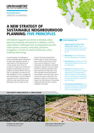
  • 1. A new strategy of sustainable neighbourhood planning: Five Principles The Five Principles are: 1. Adequate space for streets and an efficient street network. The street network should occupy at least 30 per cent of the land and at least 18 km of street length per km². 2. High density. At least 15,000 people per km², that is 150 people/ha or 61 people/acre. 3. Mixed land-use. At least 40 per cent of floor space should be allocated for economic use in any neighbourhood. 4. Social mix. The availability of houses in different price ranges and tenures in any given neighbourhood to accommodate different incomes; 20 to 50 per cent of the residential floor area should be for low cost housing; and each tenure type should be not more than 50 per cent of the total. 5. Limited land-use specialization. This is to limit single function blocks or neighbourhoods; single function blocks should cover less than 10 per cent of any neighbourhood. In recent decades, the landscape of cities has changed significantly because of rapid urban population growth. A major feature of fast growing cities is urban sprawl, which drives the occupation of large areas of land and is usually accompanied by many serious problems including inefficient land use, high car dependency, low density and high segregation of uses. Coupled with land use speculation, current models of city growth result in fragmented and inefficient urban space where urban advantage and city concept are lost. Cities of the future should build a different type of urban structure and space, where city life thrives and the most common problems of current urbanization are addressed. UN-Habitat proposes an approach that summarizes and refines existing sustainable urban planning theories to help build a new and sustainable relationship between urban dwellers and urban space, and to increase the value of urban land. This approach is based on 5 principles that support the 3 key features of sustainable neighbourhoods and cities: compact, integrated, connected. UN-Habitat supports countries to develop urban planning methods and systems to address current urbanization challenges such as population growth, urban sprawl, poverty, inequality, pollution, congestion, as well as urban biodiversity, urban mobility and energy. High density urban growth vs. urban sprawl DISCUSSION NOTE 3 A compact city. Paris, France © UN-Habitat/Laura Petrella Urban sprawl. Uberlandia, Brazil © UN-Habitat/Alessandro Scotti URBAN PLANNING
  • 2. URBAN PLANNING DISCUSSION NOTE 3 2 Objectives of the Five Principles In supporting sustainable neighbourhoods, the Five Principles seek to: 1. Promote high density urban growth, alleviate urban sprawl and maximize land efficiency. 2. Promote sustainable, diversified, socially equal and thriving communities in economically viable ways. 3. Encourage walkable neighbourhoods and reduce car dependency. 4. Optimise use of land and provide an interconnected network of streets which facilitate safe, efficient and pleasant walking, cycling and driving.(1) 5. Foster local employment, local production and local consumption. 6. Provide a variety of lot sizes and housing types to cater for the diverse housing needs of the community, at densities which can ultimately support the provision of local services.(2) Key features of sustainable neighbourhoods The Five Principles promoted by UN-Habitat are meant to foster sustainable urban development by creating livable and efficient neighbourhoods. Sustainable cities are prosperous, convenient, livable, and safe. A sustainable city would possess the following key features, which the Five Principles contribute to: 1. A vibrant street life: Supporting and promoting street life by enabling a variety of activities, conducive frontage and street width, and reducing the presence and role of private transport. The Five Principles encourage high density and mixed land use which boost a lively street life. A high population density generates sufficient industrial and commercial service demand while mixed land use provides adequate manufacturing and service space. Cities consistent with the Five Principles are able to link demand with supply and thus stimulate a prosperous city street life which satisfies people’s material and spiritual needs and creates a safe and vibrant city life. This is a key feature of sustainable cities. 2. Walkability: Promoting walkability as a key measure to bring people into the public space, reduce congestion and boost local economy and interactions. A vibrant street life encourages people to walk or cycle around, while a rational street network enables necessary city administrative services to be offered within walking or cycling distance and ensures security. High density, mixed land use and a social mix make proximity to work, home and services possible. Walkability helps to reduce automobile reliance and thus alleviate relevant congestion, air pollution and resource depletion issues. It is healthier to “walk more and drive less”! Pedestrians add an incredible amount of vibrancy to city life. 3. Affordability: Supporting affordability of transactions and economic activities, as well as of services and housing, by promoting proximity and reducing costs and building services for a diverse group of users. Proximity, brought about by applying the Five Principles, helps to reduce wastage of time and resources and thus brings down general service costs. Furthermore, the social mix principle tries to promote a rational distribution of urban public resources and provides adequate housing for different revenue groups through city planning regulations - ensuring social equity and promoting economic efficiency. An affordable and accommodating city is a core feature of a sustainable city. Malian street, Beijing, China © UN-Habitat/Jimin Zheng Bute Street, Vancouver, Canada © UN-Habitat/Shan Zheng
  • 3. Five Principles of Sustainable Neighbourhood Planning 3 Principle 1 Adequate space for streets and an efficient street network The street network should encompass at least 30 per cent of the land with at least 18 km of street length per square kilometer. Principle 1 aims to develop an adequate level of street network that not only works for vehicles and public transport but also specifically aims to attract pedestrians and cyclists.(3) It will include a street hierarchy with arterial routes and local streets based on traffic speed differences. The street network will also shape the urban structure which, in turn, sets the pattern of development blocks, streets, buildings, open spaces and landscape.(4) Principle 1 provides the material basis for sustainable urban development. To design the street network in a high density city, the amount of land needed for roads and parking needs to be determined. According to research on urban impervious surface coverage (Figure 1), complex functions and high population density require high street coverage. The research indicates that 20-30 per cent of urban land and 40-60 per cent of commercial centre land is used for roads and parking. In high density mixed-use urban areas, it is recommended that at least 30 per cent of land is allocated for roads and parking, and at least 15-20 per cent is allocated for open public space. Figure 1: Surface coverage (Arnold and Gibbons 1996) (5) transport catchment is another important factor in designing a street hierarchy. (See Figure 2). Figure 2: Catchment areas for several transport forms Stop interval Corridor width area served Catchment per stop Minibus 200M 800M 320-640 Bus 200M 800M 480-1,760 Guided Bus 300M 800M 1,680-3,120 Light Rail 600M 1,000M 4,800-9,000 Rail 1,000M+ 2,000M+ 24,000+ Source: Urban Design Compendium (ww2.newham.gov.uk/Documents/UDC.pdf) Combining walkability and public transport catchment, the suggested distance between two arterial routes is between 800 to 1,000 m. This distance is the constraint for the street grid design, urban structure design and neighbourhood size. To help explain the reason for the 18 km street length per square kilometre, Figure 3 shows a simple street network model. In an area of one square kilometre, nine vertical and nine horizontal streets are designed to form a street network. The distance between two adjacent streets is 111 m, and the total street length is 18 km. In this street network model, both street hierarchy and block size are considered. This simple model demonstrates the balance between street and other land uses. City management and urban planners could “adjust” the design pattern of the street network, but a street density level similar to the one recommended in the model should be maintained. Figure 3: Street network model design To develop sustainable mobility, the design of the street network should differ from the modernist practice in the following aspects: • Streets are walkable and cyclist friendly • Public transport is encouraged • Road hierarchy is highly interconnected • Sufficient parking space is provided These characteristics should be reflected in the street design and construction. Walkability in a neighbourhood can be measured by the walking distance to key services; this is usually from 400 to 450 m. Public Principle 1 encourages efficient traffic, sustainable accessibility, social interaction, public safety and access to amenities. 60% 50% 40% 30% 20% 10% 0 Effective Coverage High Density Residential Multifamily Commercial Low Density Residential Streets Sidewalks Parking/Driveways Roofs Lawns/Landscaping
  • 4. URBAN PLANNING DISCUSSION NOTE 3 4 Principle 2 High density At least 15,000 people per km²; that is, 150 people/ha or 61 people/acre. Principle 2 addresses population growth and is a direct response to the global population explosion and rapid urbanization. To prevent urban sprawl and promote sustainable urban extension, it is necessary to achieve high density, which is the foundation of a sustainable neighbourhood. High density essentially means a concentration of people and their activities. Figure 4 below shows the density of the built-up area of some select cities. Figure 4: 16 cities listed by population density Rank City / urban area Country Population Built up area (in km²) Built up area density (people per km²) 1 Dhaka Bangladesh 9,196,964 165.63 55,530 2 Hong Kong China 5,179,089 97.63 53,050 3 Mumbai India 16,161,758 370.90 43,570 4 Rajshahi Bangladesh 599,525 20.26 29,590 5 Milano Italy 3,708,980 635.17 27,380 6 Casablanca Morocco 3,004,505 114.31 26,280 7 Cairo Egypt 13,083,621 569.17 22,990 8 Seoul Korea, Republic of 14,546,082 706.14 20,600 9 Ho Chi Minh City Vietnam 4,309,449 210.33 20,490 10 Singapore Singapore 4,309,797 245.24 17,570 11 Mexico City Mexico 17,224,096 1,058.53 16,270 12 Santiago Chile 5,337,512 438.51 12,170 13 Bangkok Thailand 9,761,697 1,025.93 9,510 14 Beijing China 11,866,211 1,576.38 7,530 15 Paris France 9,519,527 1,482.08 6,420 16 Castellon Spain 268,712 82.03 3,280 Source: A Global Sample of 120 Cities, 1990-2000 (http://www.lincolninst.edu/ subcenters/atlas-urban-expansion/global-sample-cities.aspx) Figure 4 shows that high density is a feature of cities at different development levels and contexts. According to the same source, in 2000, cities in developing countries had an average built-up area density of 129 p/ha.(6) To promote a high population density and stop the downward trend worldwide, Principle 2 defines a minimum of 150 p/ha for a sustainable neighbourhood – which is feasible, though slightly above the average density mentioned above. Cities in land rich or developed countries, however, may set a lower target and work progressively towards increased density. Compared with low density, high density has economic, social and environmental benefits as follows: • Efficient land use slows down urban sprawl because high density neighbourhoods can accommodate more people per area. • Reduced public service costs. High density neighbourhoods tend to decrease the costs of public services such as police and emergency response, school transport, roads, water and sewage, etc.(7) • Support for better community service. • Reduced car dependency and parking demand, and increased support for public transport. • Provision of social equity. • Support for better public open space. • Increased energy efficiency and decreased pollution. People may worry about the perceived connection between density and social problems, such as crime, poverty and depression, but studies show no such correlation when factors such as income are accounted for.(8) A well-designed and organized high density neighbourhood can be safe and comfortable, but a good quality design is essential to achieve viable high density areas. In the context of fast urbanization, high density is a smart choice and is at the core of sustainable urban planning. Site area (hectares) 12.48 Parking (space per unit) 0.5 Tenure Private 843 Social rented 940 Density (Dph) 142 Density (Hrh) 557 High density neighbourhood - Churchill Gardens, London, England.(9) © Greater London Authority. Used with Permission. Note: Dph-Dwellings per hectare Hrh- Habitable rooms per hectare Location: Churchill Garden, London Density, parking and site area:
  • 5. Five Principles of Sustainable Neighbourhood Planning 5 Principle 3 Mixed land-use At least 40 per cent of the floor space is allocated for economic use in any neighbourhood. Principle 3 is aimed at developing a range of compatible activities and land uses close together in appropriate locations and flexible enough to adapt over time to the changing market. The purpose of mixed land-use is to create local jobs, promote the local economy, reduce car dependency, encourage pedestrian and cyclist traffic, reduce landscape fragmentation, provide closer public services and support mixed communities. Mixed land-use can be applied at different spatial levels: city, neighbourhoods, blocks and buildings. Principle 3 focuses on the neighbourhood and block level. At the end of the nineteenth century, with the introduction of modern urban planning concepts, the land-use zoning approach was applied and single function areas came into existence in cities all over the world. The adoption of single-use zoning strategies has resulted in serious problems for cities. Urban sprawl has increased, the quality and vitality of many urban centres has declined, and car dependence and traffic congestion affect everyone. To solve these problems, new urbanism promoted the core concept of mixed land-use. Mixed land-use requires some combination of residential, commercial, industrial, office, or other land-use. When different functions are mixed in one neighbourhood, economic and residential activities should be made compatible and well balanced by careful design and management. The compatibility of different land uses depends mainly on the noise and pollution levels. A careful study on land use compatibility should be carried out to protect the community wellbeing and area livability. According to research done in the 1950s on land use in Central Business Districts (CBD), 68 per cent is the optimum floor area allocation for economic uses, 22 per cent for residential use and 10 per cent for public service use.(10) Figure 5 gives a summary of floor area allocation in several CBDs. Figure 5: Allocation of floor area in five CBDs. Beijing Chao yang CBD Shang hai Lujiazui CBD Shen zhen CBD Paris la Defense CBD Tokyo’s Water- front Subcen- tre Area (km2 ) 4.02 1.7 4.13 1.6 4.48 Total floor areas Mm² 10.72 4 7.8 3.5 7 % 100 100 100 100 100 Economic uses floor areas Mm² 7.19 3.27 4.8 2.9 3.8 % 67 81 62 82 55 Public ser- vice floor areas Mm² 0.55 0.43 100 6 1.15 % 5 11 13 2 16 Residential floor areas Mm² 2.97 0.3 200 54 2.05 % 28 8 25 16 29 Source: CBD规划策划重点分析研究 http://wenku.baidu.com view/1c07d5630b1c59eef8c7b42f.html Note : Mm²- Million square metres However, if too little area is for residential use, the CBD or neighbourhood will decline. For example, in the 1990s, the inner city of Los Angeles was on the wane. By applying a mixed-use concept to reform the city, people were drawn back to the city centre. In 1998, downtown Los Angeles was home to around 18,000 people, now, it houses nearly 50,000 residents. (11) Downtown Los Angeles has shifted from a 9 to 5 CBD to a 24-7 prosperous neighbourhood. Based on the above research and analysis on CBDs, the suggested floor area distribution for a sustainable neighbourhood is: 40 to 60 per cent for economic use, 30 to 50 per cent for residential use and 10 per cent for public services. The set of recommended standards is a range to allow for flexibility so that different cities can adapt them to their own situations. Mixed land-use is an inherent part of the nature of cities and is a pillar of sustainable urban development. High density mixed-use neighbourhood - Addison Circle, Addison, Texas, United States.(12) © Town of Addison. Used with permission Land size 501,800 m² Residential floor area 436,600 m² Dwelling 4,800 Units Density 95 Du/Ha Economic use floor area 557,400 m²
  • 6. URBAN PLANNING DISCUSSION NOTE 3 6 Principle 4 Social mix The availability of houses in different price ranges and tenure types in any given neighbourhood to accommodate different incomes; 20 to 50 per cent of the residential floor area is distributed to low cost housing, and each tenure type should be no more than 50 per cent of the total. Principle 4 aims to promote the cohesion of and interaction between different social classes in the same community and to ensure accessibility to equitable urban opportunities by providing different types of housing. Social mix provides the basis for healthy social networks, which, in turn are the driving force of city life. Social mix and mixed land-use are interdependent and promote each other. Mixed land-use and appropriate policy guidance lead to social mixing. In a mixed land-use neighbourhood, job opportunities are generated for residents from different backgrounds and with different income levels. People live and work in the same neighbourhood and form a diverse social network. Social mix is a socio-spatial concept, with the following objectives: • to promote more social interaction and social cohesion across groups; • to generate job opportunities; • to overcome place-based stigma; • to attract additional services to the neighbourhood; • to sustain renewal/regeneration initiatives; (13) Although social mix is a socio-spatial concept that is difficult to analyse quantitatively, it is still possible to set a numerical standard from the empirical evidence based on good practice in Europe. In Holland, areas regulated by the VINEX policy are earmarked for new housing, 30 per cent of which must be affordable. In Ireland, new “set aside” policies stipulate that 20 per cent of all new development must be set aside for affordable housing (inclusionary zoning). In the United Kingdom, the system is known as planning gain and the thresholds for affordable housing are normally set at around 25 per cent of new development, with the exception of London where the percentage is being raised to between 30 and 50 per cent.(14) After analyzing the above information, it is recommended that between 20 and 50 per cent of the residential floor area is allocated to affordable housing, and one single tenure type should not exceed 50 per cent of the residential floor area. The recommendation has a wide range to enable urban planners and city management to follow the national or regional owned-to-rented ratio. When implementing this recommendation, market factors should not be overlooked. To ensure the smooth implementation of the above criteria and achieve social mix there are many possible policy options. Depending on their social and economic development stage, cities should select proper policies to create a package that promotes a balanced, developed local community. Possible policies include: • promoting social mix by mixing tenures and developing sales programmes within public estates; • achieving social mix through allocation policies and the spatial distribution of poor households.; • investing in and improving public housing; • achieving social mix by urban and housing design; • promoting multi-level employment within the community; • working with private developers to increase public housing supply;(15) • providing plots in different sizes and with different regulations, to increase the diversity of housing options. Social mix is not an urban planning panacea for social problems such as poverty and social segregation, but it can contribute significantly to their solution. Combined urban planning approaches are needed to tackle these urban challenges. This social mix principle is not a short-term concept, but should be applied with caution and over time. Social mix neighbourhood - Greenwich Millennium Village, London, England.(16) © Source: Google Maps Note: Dph-Dwellings per hectare, Hrh- Habitable rooms per hectare Location: Greenwich Peninsula, London. Density, parking and site area: Phase 1 2 3 4 Total Site area (hectares) 2.44 4.72 3.17 4.86 15.19 Parking (space per unit) 0.93 1.10 0.83 1.24 1.03 Tenure Private 444 354 424 335 1557 Affordable 43 85 81 276 485 Density (Dph) 199 93 159 126 134 Density (Hrh) 579 276 454 371 371
  • 7. Five Principles of Sustainable Neighbourhood Planning 7 Principle 5 Limited land-use specialization To limit single function blocks or neighbourhoods; single function blocks should cover less than 10 per cent of any neighbourhood. Principle 5 aims at adjusting/limiting the use of functional zoning to implement mixed land-use policies. Zoning is a land use planning device used by local governments and urban planners in many countries. Zoning may be use-based (regulating the uses to which land may be put), or it may regulate building height, lot coverage and similar characteristics or a combination of these.(16) This principle focuses on the land-use aspect. At the city level, the unilateral application of land-use specialization creates many single-function neighbourhoods, which is the source of contemporary urban challenges including city congestion, segregation, car dependency, etc. Limiting land- use specialization is important to create mixed land-use. There are two ways to adjust zoning policies and apply Principle 5: • to combine compatible land-uses into one block and neighbourhood; • to introduce mixed land-use zoning while respecting market demand and cities’ urban by-laws and regulations. In the process of implementing Principle 5, adjusting the zoning policy according to the needs is important. To further illustrate how to implement limited land-use specialization, the example of the Canadian city of Vancouver’s Burrard Slopes IC Districts is shown below. Burrard Slopes IC Districts, an area of 0.55 km², was created in the 1990s as an industrial-only area. The zoning policies of Burrard Slopes have been adjusted several times since 1993 and the area is now an industrial, commercial, residential and mixed- use zone. In this district, economic and residential land-use is well balanced by careful design and management. Service and light industrial jobs have increased; residential development projects have been introduced and population density and activities are growing. A single function neighbourhood has been converted into a vibrant multi-functional community. Burrard Slopes IC Districts’ successful experience illustrates the implementation of Principle 5 by adjusting the zoning code. Reforming a single-function zoned neighbourhood is not only a challenge but is also an opportunity for local governments and urban planners. Principle 5 is an urban planning tool to ensure the implementation of mixed land-use and to increase economic diversity. Industrial, Commercial, Residential and Mixed Use Zones, Burrard Slopes, City of Vancouver, British Columbia, Canada Source: Google Maps Source: Burrard Slopes IC Districts Interim Policies 1996 Source: City of Vancouver Zoning map, 2006 Industrial Commercial Mixed Use Zones, Burrard Slopes, City of Vancouver, British Columbia, Canada: Key milestones: Burrard Slopes IC Districts Interim Policies; Adopted by City Council 24 June, 1993; Amended 21 April, 1994, 23 July, 1996 and 10 September, 1996; Burrard Slopes IC Districts Interim Rezoning Policies and Guidelines; Adopted by City Council on 29 November, 2007; Amended 19 January, 2010
  • 8. URBAN PLANNING DISCUSSION NOTE 3 8 Application of the Five Principles The Five Principles can be applied in the following contexts: 1. Fast growing cities - the Five Principles can be applied to help cities that have to provide land, infrastructure and public services for a fast-growing population resulting from: natural growth; rural immigrants seeking employment; or even internally displaced people fleeing conflict or disaster. 2. New urban settlements and urban extensions - the Five Principles can be applied in new urban areas to avoid repeating past mistakes. 3. Urban renewal and renaissance - declining cities can apply the Five Principles for revitalization and urban transformation initiatives. 4. Urban densification - growing cities that have no land for further extension can use the Five Principles to achieve a smoother densification process. Status analysis: Neighbourhood profiling The Five Principles provide a set of quantitative measurements that can be used to analyze a neighbourhood. Figure 6 gives the recommended ranges of quantitative measurements (in green). City or neighbourhood statistical data can be plotted on this chart, and the development status of that area can be visualized. The chart, combined with more traditional criteria of sustainability, may allow stakeholders to assess a neighbourhood and may point to possible actions to improve the neighbourhood profile or to support public discussion on the same. Figure 6: Sustainability analysis of a neighbourhood To help to apply these principles and help the public to understand them, the Five Principles are explained in clear language with a series of numerical standards proposed as a reference point. The principles do not represent a comprehensive theory and only cover some basic characteristics of sustainable urban planning. The public can use them to make a quick and intuitive judgment on whether a community possesses the capacity for sustainable development. The Five Principles can also help to draft future urban scenarios and urban plans. Final Considerations The Five Principles are highly interrelated and support each other. High density provides the population and activity basis for a sustainable neighbourhood; adequate street density is the material basis; mixed land-use and social mix shape the land- use and social life in the neighbourhood; and limited land use specialization is the first step towards mixed neighbourhoods. The Five Principles balance population growth, economic growth, rapid urbanization, sustainable urban development and other factors, and try to establish a new urban system. In this system, population and urban infrastructure accomplish economies of scale; diversified social networks and the diversity of land-uses support each other and develop together; and urban space and urban dwellers live and develop in harmony. Besides good planning and design decisions, the application of these principles also require supporting legal frameworks, an analysis of the local society and economy, appropriate infrastructure technology and capacity, and the institutional capacity to enforce decisions. Percentage Formula Unit Principle Street land-use Total floor area (30-45%) Principle 1 Population density (15-60 k people/km2 ) Principle 2 Economic floor area Total floor area (40-60%) Principle 3 Residential floor area Total floor area (30-50%) Single tenure Residential floor area (0-50%) Principle 4 Affordable housing Residential floor area (20-50%) Single function block area Neighbourhood area (0-10%) Principle 5 0 10 20 30 40 50 60 70 80 90 100 UN-Habitat (United Nations Human Settlements Programme) Urban Planning and Design Branch P.O.BOX30030 Nairobi 00100 Kenya Tel: +254 20 7623706 updb@unhabitat.org www.unhabitat.org Jan 2015 Footnotes: Details of the references in this Discussion Note can be found on the electronic version at http://www.unhabitat.org/pmss/listItemDetails. aspx?publicationID=3518