Water balance assessment of the Gandaki River Basin
•
2 likes•371 views

Understanding the hydrological aspects of the Himalayan Rivers is important for water resource planning and development. The transboundary Gandaki River originates from high altitude areas of Nepal (and few tributaries from China) and flows downstream to the Indo-Gangetic Plain before meeting with the mighty Ganges.

Recommended
Recommended
More Related Content
What's hot
What's hot (20)
Similar to Water balance assessment of the Gandaki River Basin
Similar to Water balance assessment of the Gandaki River Basin (20)
More from HI-AWARE
More from HI-AWARE (14)
Recently uploaded
Recently uploaded (20)
Water balance assessment of the Gandaki River Basin
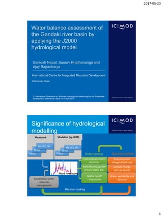
- 1. 2017-05-23 1 International Centre for Integrated Mountain Development Kathmandu, Nepal Water balance assessment of the Gandaki river basin by applying the J2000 hydrological model Santosh Nepal, Saurav Pradhananga and Ajay Bajracharya 3rd International Conference on “Mountain Hydrology and Meteorology for the Sustainable Development”, Kathmandu, Nepal, 10-11 April 2017 Significance of hydrological modelling Environmental changes (land use) Climate change (precip, temp) Water availability and demand Scenarios analysis hydrological system dynamics Role of snow, glacier ground water etc. Spatial runoff components Understanding Sustainable water resources management Decision making Precip Temp RH, WS, SH.. Measured Hydrological models Precip Temp RH, WS, SH.. Modelled (eg.WRF) Flood forecasting
- 2. 2017-05-23 2 Motivation • Importance of the Gandaki river basin – Hydropower development (about 350 MW) – Future potential for hydropower (~10% so far) – Irrigation potential (1.1M ha in India & 0.4 M ha in Nepal) • Understanding present hydrology of the Gandaki river basin – Water balance assessment – Snow and glacier melt contribution – Spatial distribution of different variables (precipitation, ET etc) • We used process based J2000 hydrological model and compared the model discharge in different percentiles Gandaki River basin
- 3. 2017-05-23 3 Gandaki River basin Main Features • High gradient and steep topography (450-8,000 m) • Sub-tropical to alpine climate • Total area: 32,000 km2 Station network • 21 meteorological and 4 climate stations • Discharge station (Devghat) Land cover • Agriculture: 40 • Forest areas : 22% • Bareland : 15 • Glacier : 7% • Rest: 15% J2000 hydrological model: Process based distributed model • Glacier melt approach – Enhanced degree day factor • Distributed output for each HRU • Open source (test data Dudh K) • Implemented in JAMS framework • Successfully implemented in Nepal Himalayan (Koshi, Gandaki, Marsyandi, Karnali) • Micro-meso to macro scales in the range of 18 km2 to 88,000 km2 Krause, 2001 Nepal et al. 2014 www.jams.uni-jena.de
- 4. 2017-05-23 4 Topography Land-use, land- cover Soil-types GIS Overlay HRU 1 HRU 4 HRU 2 HRU 3 HRU 5 HRU 6 Reach 1 Reach 3 6059 HRUs Reach 2 Distribution of modelling entities Hydrological Response Unit (HRUs) Modelling strategy • Calibration (1999-2004) and validation period (2005-2009) – 1998 as warming period • Optimization of parameter – Trail and error method based on parameter settings from previous studies • Nepal et al. 2014: Dudh Koshi (HydroProc) • Nepal et al. 2016: Parameter transferability in Dudh Koshi and Tamor • Larger Koshi (unpublished) • Comparing results with objective functions – Different percentile values (Q90, Q90-75, Q75-50, Q50) • Distributed water balance assessment
- 5. 2017-05-23 5 Percentile distribution of hydrograph Floods High flows Mid range flows Low flows Floods High flows Mid range flows Low flows 2001 Modelling results: Calibration period (1999-2004) Discharge(m3/sec) 15% increase in precipitation during the monsoon period (JASO)
- 6. 2017-05-23 6 Modelling results: Validation period (2005-2009) Efficiency criteria 1999-2004 2004-2009 Nash-Sutcliffe 0.94 0.95 R2 0.96 0.95 RMSE 434 360 Nepal et al. 2013, Hydro. Proce. Discharge(m3/sec) Comparison of hydrographs for different percentile values Floods (>Q90) High flow (Q75-Q90) Mid range flow (Q60-75) Low flows (<Q50) ObsQ (m3/sec) SimQ(m3/sec) ObsQ (m3/sec) SimQ(m3/sec) ObsQ (m3/sec) SimQ(m3/sec) ObsQ (m3/sec) SimQ(m3/sec) R2: 0.55 R2: 0.83 R2: 0.5 R2: 0.63
- 7. 2017-05-23 7 Precipitation (2126 mm) 21 33 44 81 192 330 542 501 297 75 6 6 Potential Evapotranspiration (867 mm) 41 51 92 108 109 88 80 77 70 64 48 39
- 8. 2017-05-23 8 Actual Evapotranspiration (611 mm) 20 24 40 54 82 78 77 75 66 50 27 18 Runoff (1515mm) 52% 14% 34%
- 9. 2017-05-23 9 Hydrological system analysis (1986-1997) Glacier melt contribution: 13% • Snowmelt: 5% • Glacier ice: 8% Snowmelt (outside glacier): 9% Runoff components Overland flow (RD1) : 52% Interflow (RD2+RG1) : 14% Baseflow (RG2) : 34% Overland flow dominates the hydrograph Water balance of the Gandaki river basin Icemelt 122 mm Evapotranspiration 692 mm (33%) Surface runoff 789 mm (52%) Interflow 209 mm (14%) Groundwater 518 mm (34%) Precipitation 2126 mm
- 10. 2017-05-23 10 Conclusions • High spatial variability in precipitation distribution • The J2000 hydrological model is able to represent hydrological dynamics for different percentiles values – Higher confidence in low flows than high flows • The overland flow dominates the hydrograph and singificant contribution from baseflow • Glacier contributes 13% of the total discharge, although pre- monsoon contribution is significant (7-28%) • Future plan – Climate chagne scenarios using RCP 4.5 and 8.5 and impact on hydrological regime and extreme Thank You!